Basin: Anadarko
County: Ness County
Schaben Field
You can explore the Schaben Field by clicking on the blue topic buttons to the left.Use the Schaben Site Map to learn what resources are available for the Schaben Field.
|
| ||
|
|
Play: Lower
Mississippian Basin: Anadarko County: Ness County Schaben FieldYou can explore the Schaben Field by clicking on the blue topic buttons to the left.Use the Schaben Site Map to learn what resources are available for the Schaben Field. |
|
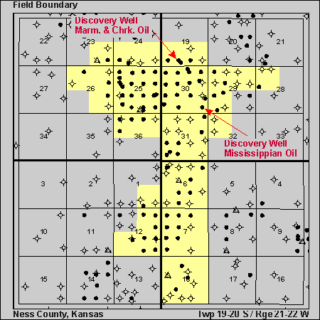 Discovery Well
Cities Service Oil Company, #1 Moore 'B'
SE SE 30-T19S-R21W
09/04/63, Mississippian Oil, 4494' RTD
American Warrior, #1 Wittman, 'OWWO'
Champlin Petroleum, #1 Wittman
SE SW, 19-T19S-R21W
06/20/91, Marmaton & Cherokee, 4407' RTD
Field Size: 8,880 acres
Total Wells: 90
Productive Wells: 65
Abandoned Wells: 25
Cumulative Oil: 10,416,796 bbls as of 7/1/96
Cumulative Gas: 112,395 mcf as of 7/1/96
Class 2 Project Page also has info on the
Schaben field.