Kansas Geological Survey, Public Information Circular (PIC) 22
Prev. Page--Recharge Research
![]()
![]()
![]()
![]()
Kansas Geological Survey, Public Information Circular (PIC) 22
Prev. Page--Recharge Research
In studying hydrologic systems, scientists generally construct a water budget. This is somewhat similar to a household budget, but instead of measuring income and expenses, a water budget measures water coming into a system and water going out of a system. In a system that is in balance, the amount of water entering the system, either through precipitation or movement underground, roughly equals the amount of water leaving the system, either for use by plants or via springs, seeps, creeks, or streams.
When recharge is low and additional uses are introduced, such as heavy pumping, water-level declines are almost certain to occur. Pumping more water than is entering the system is similar to spending more money than is in a checking account and is called an "overdraft." When water is removed from underground at the rate of feet per year, as it is in parts of western Kansas, and recharge is less than 0.3 inches per year, recharge is almost negligible in terms of overall water use.
To extend the life of aquifers in semi-arid parts of Kansas, reliance on recharge can only be a small part of the answer. Reduction of demand will play a larger role, through water-conservation measures, increasing irrigation efficiency, improving crop productivity, recycling and re-use, learning more about ground water and irrigation through research, making information available through education, and establishing water-sharing networks. Many of these actions are underway in Kansas, and information is available from local groundwater management districts, the Kansas Geological Survey, the U.S. Geological Survey, the Division of Water Resources of the Kansas Department of Agriculture, the Kansas Water Office, the Ogallala Aquifer Institute, and Kansas State University's Extension Service, among others (for information on the High Plains aquifer in Kansas, visit the website www.hiplain.org). Additional information on recharge is available in the literature (for example, see Lerner et al., 1990; Alley et al., 2002; Sophocleous, 2003; and an entire "Ground-water Recharge" recent theme issue in Hydrogeology Journal, v. 10, no. 1, February 2002).
One possible solution to declining water levels is to artificially increase the amount of water moving into an aquifer. Artificial recharge requires an additional source of water to put into the ground, which is generally a problem in areas such as western Kansas that are already short of water. That was the major reason for discontinuing several small-scale recharge projects (including the use of playas to recharge underlying aquifers) attempted in the late 1970's and early 1980's in Kansas. Moving water from areas where water is plentiful, such as eastern Kansas, to water-short areas in western Kansas has been proposed over the years, but the high cost of transferring water over great distances (several hundred miles) and increased elevations (from about 1,000 feet in eastern Kansas to nearly 4,000 feet in the west) makes it uneconomical.
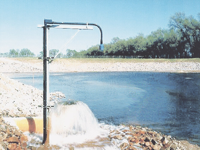
A more successful artificial-recharge project has been carried out in the Equus Beds Groundwater Management District in south-central Kansas. Water is taken from the Little Arkansas River during times of high flow and from wells in the aquifer immediately surrounding the Little Arkansas. That water is then pumped a few miles and transferred to wells, ponds, and other structures where it is put into the Equus Beds portion of the High Plains aquifer, an important source of drinking water for the city of Wichita and other cities, and a source of water for irrigation and domestic use in central Kansas (fig. 6). Filtering and other treatments are used to make sure that the water put into the aquifer is of high quality. This artificial-recharge project also keeps the water table high enough to prevent a salt plume (originating from the briny Arkansas River) from migrating into the Wichita well field. While the project is still in its initial stages, it seems to have been successful in artificially moving water from a surface source (the Little Arkansas River) into the Equus Beds portion of the High Plains aquifer. (For more information visit the website http://ks.water.usgs.gov/Kansas/equus/.) In areas where surface water is relatively plentiful and in proximity to heavily used aquifers, such recharge projects may be feasible.
Figure 6--Recharge basin where water from the Little Arkansas River is recharging the Equus Beds portion of the High Plains aquifer.
Alley, W. M., Healy, R. W., LaBaugh, J. W., and Reilly, T. E., 2002, Flow and storage in ground-water systems: Science, v. 296, p. 1,985-1,990.
Hansen, C. V., 1991, Estimates of freshwater storage and potential natural recharge for principal aquifers in Kansas: U.S. Geological Survey, Water-Resources Investigations Report 87-4230, 100 p. [available online]
Lerner, D. N., Issar, A. S., and Simmers, I., 1990, Ground-water recharge--A guide to understanding and estimating natural recharge: International Association of Hydrogeologists, International Contribution to Hydrogeology, v. 8, Verlag Heinz Heise, Hanover, 345 p.
Meyer, W. R., Gutentag, E. D., and Lobmeyer, D. H., 1970, Geohydrology of Finney County, southwestern Kansas: U.S. Geological Survey, Water-Supply Paper 1891, 117 p. [available online]
Sophocleous, M. A., 1992, Ground-water recharge estimation and regionalization--the Great Bend Prairie of central Kansas and its recharge statistics: Journal of Hydrology, v. 137, no. 1-4, p. 113-140.
Sophocleous, M. A., 2003, Ground-water recharge and the water budgets of the Kansas High Plains and related aquifers: Kansas Water Resources Research Institute, Report No. KWRI02-02, 142 p.
Sophocleous, M. A., and McAllister, J.A., 1990, Hydrologic-balance modeling of the Rattlesnake Creek watershed, Kansas: Kansas Geological Survey, Ground Water Series 11, 72 p.
Sophocleous, M. A., Kluitenberg, G. J., and Healey J. M., 2002, Southwestern Kansas High Plains deep vadose zone pilot study to estimate Darcian-based ground-water recharge at three instrumented sites: Kansas Geological Survey, Open-file Report 2001-11, 120 p.
Kansas Geological Survey, Public Outreach
Web version August 15, 2003
http://www.kgs.ku.edu/Publications/pic22/pic22_4.html