Kansas Geological Survey, Public Information Circular (PIC) 15
Prev. Page--Water || Next Page--Data Uses
![]()
![]()
![]()
![]()
Kansas Geological Survey, Public Information Circular (PIC) 15
Prev. Page--Water ||
Next Page--Data Uses
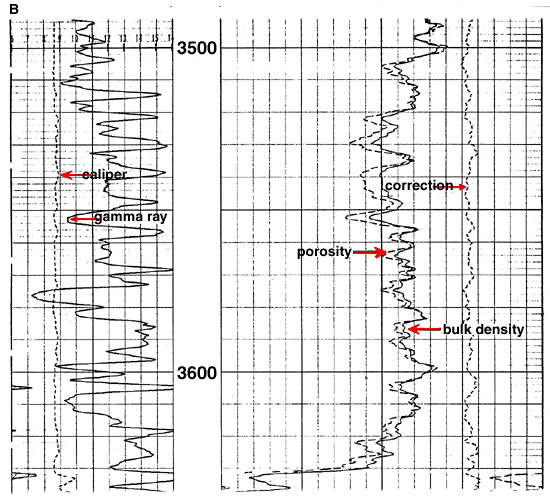
Several types of oil and gas records are available in the Data Resources Library. Over 350,000 wells have been drilled in the state of Kansas (Baars et al., 1993), and the KGS Data Resources Library has records on file for a large number of those wells. The records include Oil and Gas Well Completion Forms (ACO-1 forms) and driller's logs dating back to the 1920's. These forms generally contain information on well location, lease name, operator's name, depth, formation tops, type of completion, and dates. The Library also has geophysical logs from over half of those wells--these are graphic charts of the changes recorded in the physical properties of rocks obtained as various sensing devices (electrical, acoustic, and nuclear) were pulled up through the borehole (fig. 3).
Figure 3A and B--Sample geophysical well log based on actual data from an oil well in Logan County, Kansas. (A) The header lists the well's location and ownership and provides other information about the drilling of the well. K.B. = Kelly Bushing, D.F. = Drill Floor, and G.L. = Ground Level. (B) The curves indicate geophysical and electrical properties of the layers of rocks down the hole. Many older wells, particularly in eastern Kansas, have had no geophysical logs taken, whereas many recent wells may have sets of at least five or more different curves for each well.

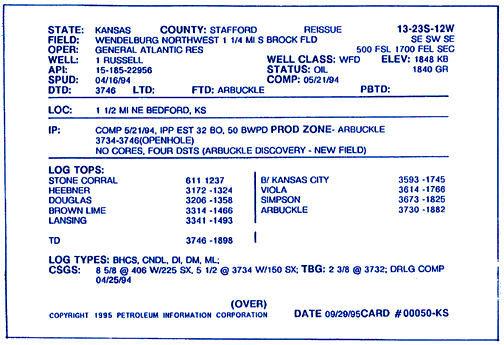
Other oil and gas records on file include scout cards (fig. 4), strip logs, and plugged well information, as well as a compilation of wells drilled into Precambrian rocks, a list of drill cores stored in the KGS Drill Core Storage Facility, and a compilation of information on oil-field brines of Kansas. The Data Resources Library also subscribes to purchased data, which are available for viewing in the library. These include new drilling locations, new completions, currently operating wells, production histories and reports, and other information pertaining to Kansas oil and gas activities.
Figure 4--Example of a scout card for an oil well in Stafford County. These cards contain information about the name, date, location, and ownership of the well, as well as producing zones and formation tops. Additional information is available on the backs of some cards (reproduced with permission from Petroleum Information/Dwights).
Oil and gas information available on the KGS website includes production data (county, field, lease, top 10 counties), digitized geophysical logs in LAS (Log ASCII Standard) format for a few wells, a listing of paper copies of electric logs available in the Data Resources Library, plugged-well information, a listing of rotary cutting samples available in the Wichita branch of the KGS, and a listing of drill cores stored in the KGS Core Library in Lawrence.
Prev. Page--Water || Next. Page--Data Uses
Kansas Geological Survey, Public Outreach
Web version October 1999
http://www.kgs.ku.edu/Publications/pic15/pic15_3.html