Kansas Geological Survey, Public Information Circular (PIC) 15
Prev. Page--Start of the Report || Next Page--Oil and Gas
![]()
![]()
![]()
![]()
Kansas Geological Survey, Public Information Circular (PIC) 15
Prev. Page--Start of the Report ||
Next Page--Oil and Gas
Water-Well Completion Forms (WWC5 forms) for water wells drilled in Kansas since 1975 are on file in the Data Resources Library (fig. 2). Some driller's records of earlier wells are also on file. They can be viewed and photocopied in the library itself, or requests for photocopies can be submitted by phone or e-mail. These forms contain information about the well's location, ownership, depth, water levels, yield (in gallons per minute), type of use, borehole diameter, and construction, as well as the name of the well driller and in some cases a driller's log, which indicates the thickness and types of rocks encountered while drilling.
Figure 2--Example of a Water-Well Completion Form (WWC5) for a well in Douglas County. Note: Although the legal description of the well location and the owner's name and address were removed from this example, this information is essential and is required on all forms.
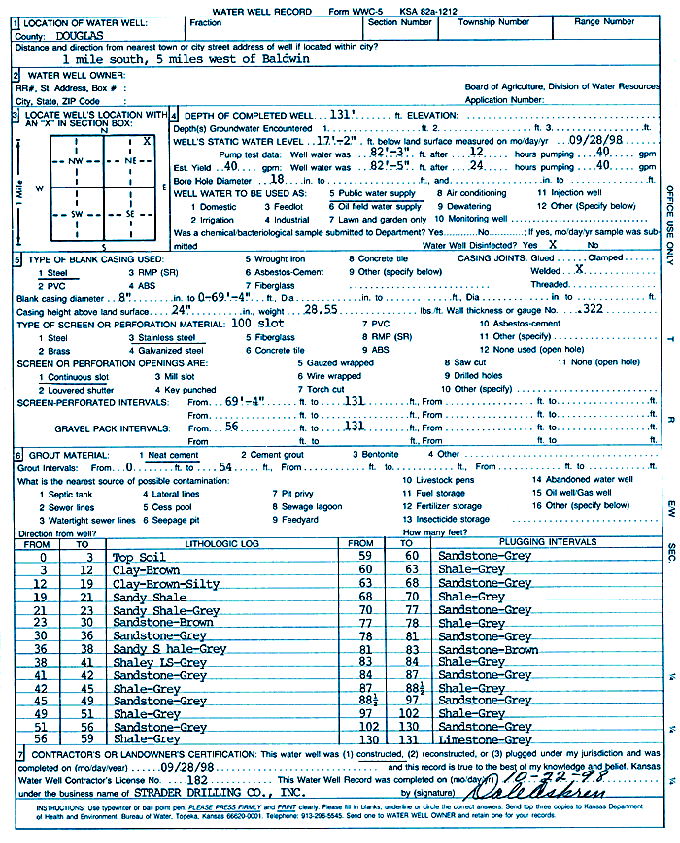
Much of the information in the KGS Data Resources Library is available on the KGS website (www.kgs.ku.edu). A nearly complete listing of water-well records on file at the KGS is available on the website. Information from a large number of these records is also available and is being continually updated; this information includes well location, ownership, depth, water levels, yield, and generalized lithologic log. Scanned images of WWC5 forms also are being added and made available online.
Prev. Page--Start of the Report || Next. Page--Oil and Gas
Kansas Geological Survey, Public Outreach
Web version October 1999
http://www.kgs.ku.edu/Publications/pic15/pic15_2.html