Kansas Geological Survey, Public Information Circular (PIC) 13
Prev. Page--Landslide Features || Next Page--Warning Signs
![]()
![]()
![]()
![]()
Kansas Geological Survey, Public Information Circular (PIC) 13
Prev. Page--Landslide Features ||
Next Page--Warning Signs
Landslides are natural phenomena that occurred in Kansas long before human occupation. The basic ingredients for landslides are gravity, susceptible soil or rock, sloping ground, and water.
The most common rocks found in Kansas are shales, limestones, and sandstones. Shales--rocks composed of clay- and silt-sized grains--are most often associated with landslides. When shale is near the ground surface where the water content fluctuates, it weathers into a clayey soil that could be landslide prone. Block slides, slumps, and earth flows commonly occur in shales and the soils developed on shales. Limestones are usually hard sedimentary rocks composed of calcium carbonate and can provide strength to slopes. Sandstones, rocks composed of sand-sized grains, can be either loosely cemented and soft or hard and resistant. Hard rock layers that resist weathering are termed competent rocks. Sandstones and limestones exposed in cliffs or roadcuts can pose a risk for rock fall, especially when they overlie shales.
Landslides require hilly terrain. In general, as the slope angle increases, the potential for landslides also increases. Anything that increases the slope angle can trigger a landslide. For example, a stream that is actively eroding a hill increases the slope angle at the base. Construction practices that increase slope angle can also cause landslides. The maximum safe slope angle for any hillside is a function of the type, thickness, and water content of soil and rock. Water acts as a lubricant in soil and rock. As water content increases, the strength of the soil and rock decreases. This can lead to landslides.
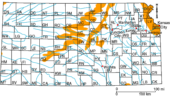
The U.S. Geological Survey (Radbruch-Hall et al., 1982) identified several regions of Kansas as landslide prone, including the Missouri River Corridor in northeastern Kansas, the Smoky Hills in northern and central Kansas, and a small area in northwestern Hamilton County (fig. 3). The Missouri River Corridor includes the Kansas City Metropolitan Area (Johnson, Leavenworth, and Wyandotte counties). Though not shown on the U.S. Geological Survey map, the region along the Kansas River and its tributaries from Kansas City to Junction City should also be considered landslide prone. This includes the cities of Lawrence, Manhattan, and Topeka. Although landslides are more likely in these regions, they can occur anywhere in the state.
Figure 3--Landslide-prone areas in Kansas as identified on the 1982 U.S. Geological Survey landslide map of the conterminous United States (Radbruch-Hall et al., 1982). Landslide risk is moderate in the shaded areas (1.5% to 15% of the area is landslide prone). Other areas in Kansas have a low landslide risk (less than 1.5% of area). Though not shown on this map, the region along the Kansas River and its tributaries from Kansas City to Junction City may also have a moderate landslide risk.
Prev. Page--Landslide Features || Next Page--Warning Signs
Glossary || Additional Reading and Internet Sites
Kansas Geological Survey, Public Outreach
Web version April 1999
http://www.kgs.ku.edu/Publications/pic13/pic13_3.html