Kansas Geological Survey, Public Information Circular (PIC) 12
Prev. Page--Measuring the Well || Next Page--Measurement Accuracy
![]()
![]()
![]()
![]()
Kansas Geological Survey, Public Information Circular (PIC) 12
Prev. Page--Measuring the Well ||
Next Page--Measurement Accuracy
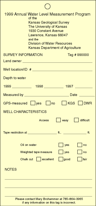
Once a well has been successfully measured, a weather-resistant tag is attached to the well so landowners can tell, from a distance, that their well has been measured. Different colored tags are used each year. The tags provide information about well location, landowner's name, measuring agency, measurement access, obstructions, the quality of the water line, oil on water, remarks, depth to water in the current year, depth to water in the two previous years, date, and measurer identification (fig. 4). Tags are for the convenience and information of owners or operators, who can remove the tags if they so choose.
Figure 4--Information on well tag.
Prev. Page--Measuring the Well || Next Page--Measurement Accuracy
Kansas Geological Survey, Public Outreach
Web version December 1998
http://www.kgs.ku.edu/Publications/pic12/pic12_3.htm