Kansas Geological Survey, Public Information Circular (PIC) 12
![]()
![]()
![]()
Kansas Geological Survey, Public Information Circular (PIC) 12
Richard D. Miller
Exploration Services, Kansas Geological Survey
Rex Buchanan and Liz Brosius
Public Outreach, Kansas Geological Survey
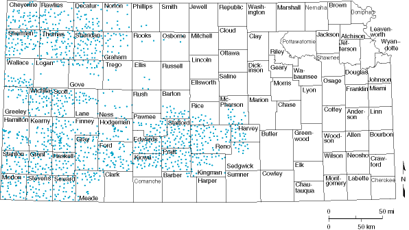
Ground water is the primary water source for much of western Kansas. In order to effectively manage ground-water use, changes in water levels and the associated saturated thickness in aquifers are regularly and accurately monitored. As part of a statewide program, about 1,380 wells in 47 central and western Kansas counties are measured annually (fig. 1).
Figure 1--Locations of wells measured by DWR and KGS in 1998 water-level measurement program.
This program, sponsored by the Division of Water Resources (DWR) of the Kansas Department of Agriculture and the Kansas Geological Survey (KGS), is designed to monitor changes and identify regional trends in the High Plains, Dakota, and alluvial aquifers.
Water levels generally are measured during January by staff from the DWR and the KGS. The measured wells are used for livestock, irrigation, households, municipalities, industries, and monitoring (abandoned agricultural or domestic wells). Approximately 90% of these wells are in the High Plains aquifer, which consists of the Ogallala Formation and hydrologically connected units that lie above the Ogallala.
The principal product of the water-level measurement program is a regional view of water levels in central and western Kansas. Regulatory agencies use this information to judiciously determine water appropriations. Ground-water management districts use the information to better understand the status of area water levels and to make management decisions. Landowners use the data to make decisions about drilling and water use. The purpose of this circular is to describe how wells are selected and measured, how the public can gain access to this information, and how this information is used.
Not all water wells in Kansas are measured as part of this program. Instead, a representative sampling of wells is made, so that the resulting measurements provide an accurate but cost-effective snapshot of water levels in the aquifer. Wells included in the annual water-level census are selected based on the following characteristics: (1) what aquifer they penetrate, (2) the presence of substantial amounts of water in the aquifer, (3) where the wells are located, (4) how they were constructed, (5) the amount of historical data available, and (6) how the wells are used. In general, one well in every 16-square-mile area is measured. Each year, for various reasons, about 5% of the previously measured wells cannot be successfully measured and must be replaced by other wells in the same area.
Of the wells measured in 1998, over half had depths to water of less than 100 feet (30 m), with slightly more than 1% with depths greater than 300 feet (91 m) (table 1). Most of the wells measured (71%) currently are used for irrigation (table 2).
| Table 1--Depth to water in wells measured in 1998 | |
|---|---|
| Depth to Water | Number of wells |
| Less than 100 ft | 651 |
| 100 to 200 ft | 509 |
| 200 to 300 ft | 130 |
| More than 300 ft | 17 |
| Table 2--Types of wells measured in 1998 | |
|---|---|
| Type of Well | Number of wells |
| Irrigation | 979 |
| Unused (monitor or abandoned) | 274 |
| Stock | 64 |
| Household | 32 |
Kansas Geological Survey, Public Outreach
Web version December 1998
http://www.kgs.ku.edu/Publications/pic12/pic12_1.htm