![]()
![]()
![]()
![]()
Kansas Geological Survey, PIC 11--Kansas Springs, Part 3 of 5
Previous Page ||
Next Page
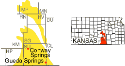
These are areas south of the city of Wichita and around the city of McPherson. The predominant bedrock is shale, which has been eroded to form a relatively flat landscape. Gueda Springs (Sumner County), on the edge of the Wellington Lowlands, was developed as a mineral water spa in 1886, with a hotel and its own lake (Bailey, 1902); the area is mostly dry today. The spring at Conway Springs (Sumner County) was once used for bottling and is today marked by a spring pavilion in a park in the center of town. Seltzer Spring (Sedgwick County) is relatively high in sulfates because of gypsum in the underlying shale.
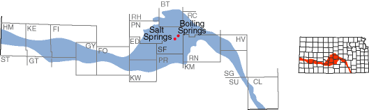
This area of sands, gravels, and other largely unconsolidated material was laid down by the Arkansas River from its entry in the western end of the state until its exit near Arkansas City. The area is largest south of the river's sweeping bend in central Kansas. Seeps and springs in Stafford County provide part of the water that supports the salt marshes at Quivira National Wildlife Refuge. Boiling Springs (Stafford County) flows at the rate of about 20 gallons per minute. Salt Springs (Stafford County) is high in chlorides and is salty to the taste.
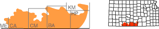
This is an area of gypsum, siltstone, and sandstone, colored brick-red by iron oxide, giving the hills their name. Like the Flint Hills, much of this area remains in native grass; also, gypsum is soft and easily dissolved by ground water, creating caverns and passages for the movement of water. However, because of the relative lack of precipitation, averaging less than 25 inches per year (Goodin et al., 1995), springs are somewhat rare and most of the them are fairly small. Springs in the pastures of Clark County, for example, provide water at a rate sufficient for pastured livestock.
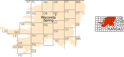
This region is marked by the sandstones, limestones, and other rocks deposited in the Cretaceous Period of geologic history, about 100 million years ago. It includes outcrops of such rock units as sandstones in the Dakota Formation and limestones and shales in the Greenhorn Limestone (one layer of which is known locally as fencepost limestone). What was perhaps the state's best known spring, Waconda Spring, once existed here in Mitchell County. This location was sacred to Native Americans (it was also known as Great Spirit Spring) and was later the site of a mineral water spa and hotel. Water from the spring deposited a large mound of the mineral travertine around it. Today it is covered by the waters of Waconda Lake. Numerous smaller springs continue to flow in pastures in the Smoky Hills; some are accompanied by petroglyphs inscribed by Native Americans on nearby outcrops of Dakota sandstone. Springs are also common in the Blue Hills area of Russell and Ellis counties.
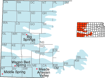
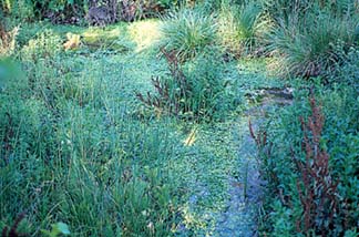
Covering the western third of Kansas, this area is largely mantled by sands, gravels, silts, and other rock debris that were washed out onto the plains from the Rocky Mountains to the west, over the past several million years. The Ogallala Formation is the most prolific aquifer in this area, and it provided the water that supported flow in many of the historic springs. With the depletion of the Ogallala because of irrigation, however, some of these springs no longer flow. Wagon Bed Spring, also known as Lower Spring (Grant County), was a stop on the Dry Route, or Cimarron cutoff, of the Santa Fe Trail; today the spring is dry. Middle Spring (Morton County), in the Cimarron National Grassland, was another camping spot on the trail; it continues to produce small amounts of water, though it is more of a seep than a spring. Springs in the Meade Artesian Valley (Meade County) have been dried up or greatly reduced as a result of lowered water levels, though a flowing artesian well continues to produce water at Lake Meade State Park. Big Springs (Scott County) at Lake Scott (fig. 5) continues to produce large amounts of water that flow into Ladder Creek.
Figure 5--Big Springs in Scott County. The spring surfaces at several points in this area and forms a spring run that can be seen in the right side of the photo.
Kansas Geological Survey, Public Outreach
Comments to webadmin@kgs.ku.edu
Web version October 1998
http://www.kgs.ku.edu/Publications/pic11/pic11_3.htm