![]()
![]()
![]()
Kansas Geological Survey, Public Information Circular (PIC) 11
Rex Buchanan,
Public Outreach, Kansas Geological Survey
Robert Sawin,
Public Outreach, Kansas Geological Survey
Wayne Lebsack,
Independent Geologist
For thousands of years, the springs of Kansas have served as important sources of water for human consumption. The activities of Native Americans--hunting expeditions, camping, and settlement sites--converged around springs. The routes of historic trails were determined by springs, such as Alcove Spring on the Oregon Trail or Diamond Spring along the old Santa Fe Trail. From Bonner Springs to Baxter Springs to Sharon Springs, towns grew up in locations where spring water was available. Even before the arrival of people on the Great Plains, springs sustained rivers and streams and provided reliable habitat for plants and animals. Springs are an important component of the Kansas landscape; they aid in understanding the connection between ground water and surface water and the impact of human activities on the environment.
Despite the historic, geologic, and environmental importance of springs, little information has been systematically collected about them in Kansas. No comprehensive inventory of their locations has been made. Few scientific publications devote more than a few paragraphs to them; references are scattered throughout the literature of various disciplines. The purpose of this circular is to describe the basic geologic conditions that create springs, discuss some of the better-known or more prolific springs in the various regions of the state, and establish their significance, both as a source of water for individuals and communities, and information about the landscape. Highlighted terms are defined in the Glossary at the end of this publication.
One of the earliest technical definitions of a spring was "a place where, without the agency of man, water flows from a rock or soil upon the land or into a body of surface water" (Meinzer, 1923). This definition contains several key components--water must flow, not simply stand, and it must flow naturally, not as a result of human activity. This definition differentiates a spring from a seep, which is defined as a discharge of water that "oozes out of the soil or rock over a certain area without distinct trickles or rivulets" (Bouwer, 1978). Another definition was developed by Walter Schoewe, who wrote extensively about the geology of Kansas; he defined springs as places where water flowed "in a distinctive current" (Schoewe, 1953). Another definition states that springs generate water in amounts sufficient to "form a channel on the earth's surface" (Webb et al., 1997). For the purposes of this circular, springs are defined as places where ground water flows naturally from the earth into a body of surface water or onto the land surface, at a rate sufficient to form a current.
Springs, then, are places where ground water moves naturally to the earth's surface. Because ground water is underground and unseen, it is not always possible to know exactly how movement takes place. In addition, each spring differs according to the geology and topography of an area. Nonetheless, it is possible to describe the general geology of springs.
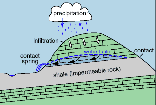
Spring water begins with precipitation that falls on the land's surface and moves down into the subsurface. That water continues to be drawn down through permeable material by gravity until it encounters a less permeable layer of rock, such as shale. While many rock layers appear to be perfectly horizontal, most have a slight incline, or dip. In Kansas, many rock units dip subtly to the west--that is, they get slightly deeper as you go from east to west across the state. Ground water moves downdip, along the contact of the permeable and less permeable rock, until it reaches a location where erosion exposes the rocks to the atmosphere, such as a stream valley or hillside, creating an outlet for the water to move onto the land. This is called a contact spring (fig. 1), the most common type of spring in Kansas.
Figure 1--Contact spring. Gravity moves infiltrating water downward and then laterally in the downdip direction on top of the less permeable rock layer.
The contact spring model works well in consolidated rocks such as limestone, sandstone, and shale that are common in Kansas. The layering that is typical of these rocks makes it easier to understand the mechanisms that create the springs. Contact springs can also occur in unconsolidated material, such as sand and gravel. Because unconsolidated materials are not uniformly layered (clay layers or lenses, for example, occur randomly and discontinuously within the sand and gravel bodies), the exact movement and mechanism of springs from unconsolidated material are more difficult to describe, especially if artesian conditions exist.
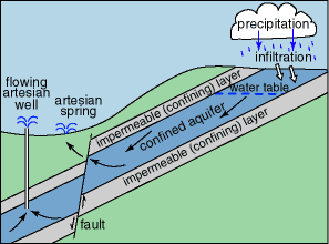
Most Kansas springs are gravity springs, where water flows to the surface by the action of gravity, as at contact springs. However, in a few of the state's springs, water is forced to the surface by artesian pressure. Under artesian conditions, the pressure in an artesian aquifer is greater than the pressure at the land surface. When the aquifer is tapped (naturally or by a well), the higher pressure in the aquifer forces the ground water to the surface, either as an artesian spring or flowing artesian well (fig. 2). Artesian springs were more common in the state before heavy pumping lowered the water table and lessened the pressure that might have created artesian conditions.Figure 2--Artesian spring. Water under artesian pressure rises to the land surface.
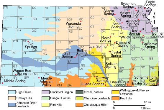
One way to group the state's springs is according to physiographic region (Schoewe, 1949), based on the physical characteristics of the land (fig. 3).
Each of those physiographic regions is distinct, and each has springs--in some regions they are relatively common; in others they are rare. The following description is meant only to be illustrative of a few of the major springs of each region. The list is not meant to be exhaustive. Most of these springs are on private property, and visitors should have landowner permission before entering.
Figure 3--Physiographic regions of Kansas and locations of springs mentioned in this circular. Some of these springs no longer exist.
Kansas Geological Survey, Public Outreach
Comments to webadmin@kgs.ku.edu
Web version October 1998
http://www.kgs.ku.edu/Publications/pic11/pic11_1.htm