Kansas Geological Survey, Public Information Circular (PIC) 10
Prev. Page--Local Ground-water Availability || Next Page--Other Sources of Information
![]()
![]()
![]()
![]()
Kansas Geological Survey, Public Information Circular (PIC) 10
Prev. Page--Local Ground-water Availability ||
Next Page--Other Sources of Information
The Kansas Geological Survey's Data Resources Library has information about the state's surface and subsurface geology and ground-water resources in the Dakota. This information can be used to locate aquifer zones, determine drilling depth, and, in some instances, to estimate water quality. The Data Resources Library contains driller's logs of water wells drilled prior to 1975; water-well completion records, required by the state since 1975; and geophysical logs of thousands of holes drilled for oil and gas in Kansas.
A driller's log is a written account, kept by the driller, of the rocks encountered during the drilling of a well. The log notes the nature of cuttings (small pieces of rock produced by the drill bit and brought up to the surface during the drilling of the well) that the well encounters. By visually examining these cuttings, the driller can piece together a picture of the rocks that make up the subsurface in the location being drilled. The log also notes the occurrence of ground water, if any. The quality of logs varies, depending on the driller's knowledge of the local subsurface geology, the quality of the cuttings, and the driller's experience in interpretation. Because these logs are often very general, they may have limited use.
Since 1975, water-well drillers have been required by law to submit driller's logs and well-construction information on WWC-5 (Water Well Record) forms. These records are submitted to the Kansas Department of Health and Environment, and copies are filed at the Survey's Data Resources Library. The upper part of the form indicates the well's location, ownership, depth, type of use, water levels, well yield, and well construction information, such as depth of the intervals at which the well is screened, and the interval at which gravel pack was placed between the borehole and the well casing (fig. 4). Although most Dakota wells are gravel packed, a few may be completed without any gravel pack (called open-hole completion), if the sandstone grains are adequately bound by natural cementing agents so as not to collapse the borehole.
The lower part of the WWC-5 form contains the driller's log of the borehole. The source of water for the well can usually be identified by comparing the well-screen and gravel-pack intervals with the driller's log. If the gravel-pack interval spans most of the depth of the well, and the well-screen interval spans only a small portion of the well depth, it may indicate that water is coming into the well from several aquifers.
Landowners who are considering drilling a well into the Dakota may want to acquire copies of the driller's logs and WWC-5 forms for nearby wells. These logs can be used to estimate drilling depths, potential yields, and the types of rocks that will be encountered during drilling. Paper copies are available from the Survey. Some WWC-5 forms are also available electronically through the Survey's home page on the World Wide Web (for access, go to the Data Base section of the Survey's home page at www.kgs.ku.edu).
Figure 4--Typical water-well construction in Kansas.

Geophysical well logs provide useful information about the subsurface. These are graphic charts of the changes in the physical properties of the rocks encountered by wells drilled for oil, gas, or water. These records are made by pulling electrical, acoustic, and nuclear sensing devices through the borehole. Most geophysical well logs are produced for the oil and gas industry; however, many of the rock properties used to locate and describe oil and gas reservoirs are also useful in the search for aquifers containing usable ground water. These logs provide quantitative information about the subsurface geology, whereas driller's logs usually consist of a generalized, somewhat subjective description of the geologic formations and the ground water encountered during drilling. Geophysical logs can be used by geohydrologists to identify and map geologic units (such as sandstone bodies) in the subsurface. They can also be used to measure the water-storage capacity of the sandstone and to estimate water quality. Some technical training is required for the interpretation of geophysical logs.
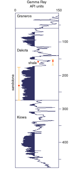
One example of a geophysical log is the gamma-ray log, a graph of the natural radioactivity emitted by the rocks encountered by the borehole. Figure 5 is a gamma-ray log of a test hole in Lincoln County that penetrates the geologic units of the Dakota aquifer. Because sandstones generally emit much lower levels of radioactivity than shales, the gamma-ray log is useful for locating sandstone aquifers. The borehole for the well shown in fig. 5 penetrates significant amounts of aquifer-quality sandstone (the shaded intervals on the log). Other geophysical logging sensors (spontaneous potential, resistivity, and porosity) that were used in this location (but not shown in fig. 5) indicate that all of the sandstones, except those near the top, contained saline water. This was later confirmed by pumping tests.
Figure 5--Gamma-ray log of a test hole in the Dakota aquifer in Lincoln County, Kansas. Shaded units are sandstones (potential water-bearing aquifers).
A type of well log that is particularly useful for determining water quality is a spontaneous potential or SP log. The sensor that produces this log measures the natural electrical currents that exist near the borehole between the sandstone and the adjacent shale units. The strength and the path taken by those currents is determined by the contrast between the salinity of the drilling mud in the borehole and the ground water adjacent to the borehole. Thus, the SP measurements on the log can be used to estimate the ground-water salinity if the salinity of the drilling mud in the borehole is known.
Copies of geophysical logs are available, for a fee, from the Kansas Geological Survey and from the Kansas Geological Society, headquartered in Wichita. Landowners who want to acquire copies of those logs will need to provide a legal description of the location where they are considering drilling. By combining the information on the driller's logs, water-well records, and interpretations of nearby geophysical logs, some idea of the depth, thickness, and water quality of subsurface aquifer zones can be obtained.
If economics permit (usually in the case of deeper, high-capacity wells), it may be helpful to run geophysical logs on test holes or new wells. In areas where limited subsurface information is available, geophysical logs may help them determine if additional drilling is warranted. Also, geophysical logs allow the driller or geohydrologist to accurately locate the top and bottom of the sandstone aquifer, and evaluate the quality of each aquifer encountered by the borehole. Without the information provided by these logs, well owners risk screening the wrong intervals in the well (they may screen shale units, which do not produce water, as opposed to the sandstone units, which do produce water), or zones containing saline water may be opened to the well bore. In addition, geophysical logs provide information that makes it possible to more accurately map the extent and thickness of the sandstone aquifers in the subsurface. The cost of a suite of geophysical logs varies according to the depth of the hole, and other factors.
Prev. Page--Local Ground-water Availability || Next Page--Other Sources of Information
Kansas Geological Survey, Public Outreach
bsawin@kgs.ku.edu
Web version May 1998
http://www.kgs.ku.edu/Publications/pic10/pic10_3.html