Kansas Geological Survey, Public Information Circular (PIC) 10
Next Page--Local Ground-water Availability
![]()
![]()
![]()
Kansas Geological Survey, Public Information Circular (PIC) 10
Next Page--Local Ground-water Availability
P. Allen Macfarlane, D. O. Whittemore, and J. H. Doveton
Because of water-level declines in the Ogallala aquifer, more and more users are looking at the Dakota aquifer, which lies beneath the Ogallala, as the next potential water source. However, the Dakota is less predictable and more sensitive to heavy development than the Ogallala and other shallower sources of ground water in Kansas.
The Dakota aquifer system consists of discontinuous sandstone bodies in the subsurface. These ribbon-like sandstone bodies occur sporadically, and the thickness of a given body can vary greatly over distances of less than a mile. At some locations, shallow zones of freshwater are found at the top of the aquifer, whereas at greater depth, salinity makes the ground water unusable. Depending on the location, freshwater or highly saline water may be found at all levels in the aquifer.
In short, the Dakota's ability to produce water can vary dramatically from place to place. One well may produce large amounts of high-quality water, while a nearby well may be dry, or pump highly saline water. As a result, the search for suitable freshwater-bearing sandstones in the Dakota aquifer can be frustrating and costly, particularly if drilling locations are simply picked at random. To minimize the cost of drilling, and to make drilling more efficient, exploration efforts need to follow a systematic approach that is based on all the available information. Using this approach, the subsurface distribution of sandstone aquifers can be assessed and suitable drilling targets identified.
This publication briefly describes information available from the Kansas Geological Survey and other organizations that can be used to develop a systematic approach to the exploration for ground water in the Dakota aquifer. Summary descriptions of the sandstone aquifer units and the factors controlling ground-water availability in the Dakota are included for background information. Terms printed in boldface type are defined in the Glossary at the end of this publication.
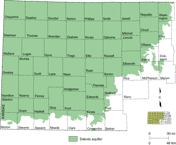
The Dakota aquifer system consists of three geologic units: the Cheyenne Sandstone, the Kiowa Formation, and the Dakota Formation. These rock layers were deposited during the Cretaceous Period of geologic history, about 100 million years ago; today they crop out or lie beneath much of the western half of the state (fig. 1). The combined thickness of these geologic units reaches a maximum of more than 700 feet (213 m) in parts of west-central Kansas. In Kansas, many of the geologic units in the Dakota aquifer consist largely of shales. These shales are not considered aquifers because they have very little pore volume and do not yield significant amounts of water to wells.
Figure 1--Extent of the Dakota aquifer in Kansas.
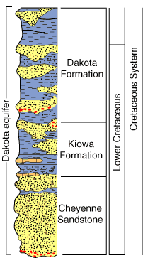
Sandstones in the Dakota aquifer, however, can be very porous, hold water, and thus serve as important aquifers. These sandstone bodies may be up to 100 feet (30.5 m) thick, 1.5 miles (2.4 km) wide, and over 20 miles (32 km) long. Though the sandstone bodies can produce significant amounts of water, they occur sporadically (as shown in the schematic geologic column in fig. 2). The sandstone component of the Dakota ranges from less than 5 percent to more than 50 percent, and varies dramatically even over distances of a few miles or less. Within Kansas, sandstone accounts for about 30 percent of the total thickness of the rocks that make up the Dakota aquifer.
Figure 2--Geologic units of the Dakota aquifer.
The amount of water the Dakota aquifer can yield depends directly on that sandstone. Yields from the Dakota can generally be placed in three categories. First, those that produce less than 50 gallons (189 liters) per minute. Second, those that produce 50 to about 200 gallons (757 liters) per minute. Wells in these two categories are sufficient for low to medium demand, including domestic, stock, industrial, and municipal uses. Wells that yield greater amounts--from 200 up to 1,000 gallons (757-10,000 liters) per minute--have been reported from Washington, Republic, Ford, and Hodgeman counties, where the Dakota is used for irrigation.
Next Page--Local Ground-water Availability
Kansas Geological Survey, Public Outreach
bsawin@kgs.ku.edu
Web version May 1998
http://www.kgs.ku.edu/Publications/pic10/pic10_1.html