![]()
![]()
![]()
Kansas Geological Survey, Public Information Circular (PIC) 29
A complete text of this file is available as a pdf document.
Donald Whittemore
Kansas Geological Survey
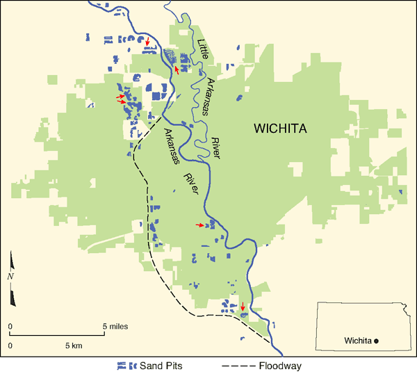
Many sand and gravel pits have been excavated for construction materials in and around Wichita in south-central Kansas (fig. 1). The water table in the alluvial aquifer in the area is so shallow that the sand pits permanently fill with water. A concern is that the water-filled sand pits provide an opening to the aquifer, such that stormwater runoff and any contaminants it contains could directly enter the ground water. After sand and gravel operations end, residential developments often are built around the pits, which contributes to the runoff.
Figure 1--Distribution of sand and gravel pits in the Wichita area. Most of the pits were mined for construction aggregate, although a few are borrow pits for highway fill. Red arrows indicate the locations of the six sand pits studied.
In 2002, Equus Beds Groundwater Management District No. 2 and the Wichita Area Builders Association formed a task force to address issues regarding the use of sand pits for stormwater-flow management. These issues include the impact that use would have on surface and ground water and identification of which management practices would best protect ground-water quality when the pits are used for runoff control. In 2004, the Kansas Legislature passed Senate Bill 364, which amended laws on water appropriation in sand and gravel pits. A new section in the bill mandated that the Kansas Department of Agriculture's Division of Water Resources (DWR) and the Kansas Geological Survey (KGS) study the impact of diverting water runoff into sand and gravel pits and make recommendations.
To address the requirements of the bill and the needs of the task force, State and local agencies developed a plan, and the Sedgwick County Department of Environmental Resources coordinated efforts to select six sand pits for detailed study. Four of the study sites are in northwest Wichita and two are in southern Wichita (table 1). Five of the pits are surrounded by residential developments that started from 1968 to 1991. A northwest Wichita pit surrounded by cropland was selected as the control site. At that site, surface runoff has not been directed into the pit, and no development or recreational use has occurred.
Table 1--Characteristics of the six sand and gravel pits selected for the water-quality study. The ages of the pits were estimated from aerial photographs.
| Name of pit | Type of area | Age of pit | Age of development |
Water surface area, acres |
Greatest measured depth, ft |
|---|---|---|---|---|---|
| Barefoot Bay | New residential area | Active 1974 | 1991-2004 | 113 | 30 |
| Ridge Port | New residential area | After 1997 | 1999-present | 87 | 6.7 |
| The Moorings | Old residential area | Active 1968 | 1978-present | 111 | 31 |
| Cropland | Control site, in cropland (wheat, corn) |
Active 1968 | 42 | 32 | |
| Kingston Cove | Apartments and commercial area |
Active 1960 | 1968-1974 | 18 | 19 |
| Pine Bay Estates | New residential, septic systems, golf course |
Active 1968 | 1986-2002 | 32 | 14 |
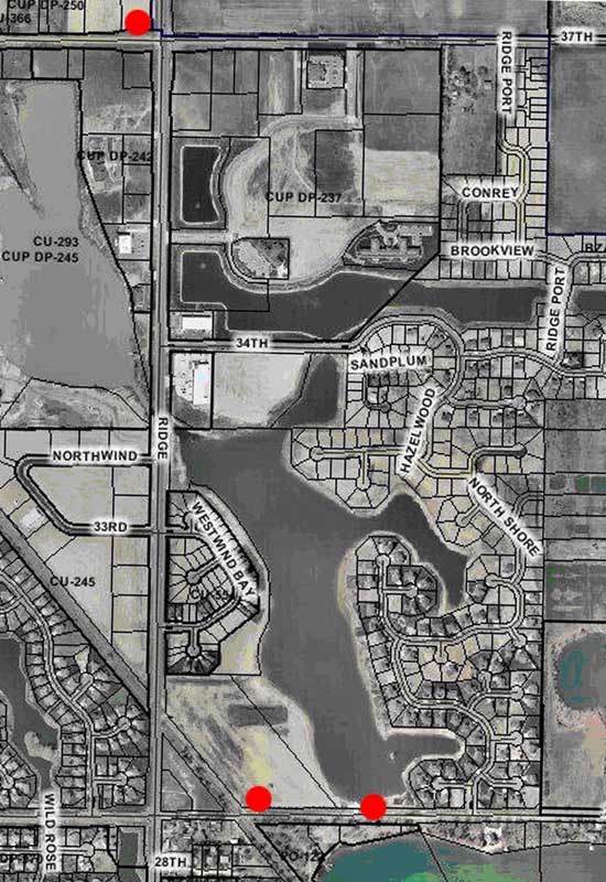
The U.S. Bureau of Reclamation installed three monitoring wells around each of the six sites, two in the downgradient direction of ground-water flow from the pit and one in the upgradient direction (see fig. 2 for well locations at one site). Downgradient wells were expected to intercept surface water that flowed into the pit, and then into the subsurface, where it would migrate in the direction of ground-water flow. Upgradient wells were not expected to be affected by the pit surface water. The southeast downgradient well at each site is generally the most in line with the south-southeast direction of ground-water flow in the area.
Figure 2--Aerial photograph of the Ridge Port pit lake in northwest Wichita. The red dots indicate the locations of the three monitoring wells.
The U.S. Geological Survey (USGS) sampled and analyzed surface water from the pits, ground water from the monitoring wells, and pit-bottom sediment at the six sites. Samples were collected and analyzed in two phases, the first in 2006 and the second in 2007. The water analyses included measurements for 18 physical and chemical properties, five bacteriological values, 40 inorganic constituents, 118 pesticide and degradate compounds, and 134 synthetic organic compounds other than pesticides. Sediments were analyzed for five physical and chemical properties, 45 inorganic constituents, and 32 synthetic organic compounds.
The KGS was responsible for interpreting, reporting, and presenting the study results. The two KGS reports, along with a PowerPoint presentation and the chemical data, can be viewed or downloaded from the web page http://www.kgs.ku.edu/Hydro/Sand/index.html. This Public Information Circular summarizes the findings of the study. Terms shown in bold are defined in the glossary at the end.
In samples from all the sites, total dissolved solids concentration exceeded the secondary standard (recommended, not regulated) of the U.S. Environmental Protection Agency (EPA) and Kansas Department of Health and Environment (KDHE). At the northwest Wichita sites, chloride concentration exceeded the secondary standard in pits and most ground waters. The source of most dissolved constituents is primarily natural (intrusion of saltwater from bedrock upstream in the basin). Iron and manganese exceeded secondary standards in some surface and ground waters. Arsenic was at or slightly greater than the primary standard in two wells. The primary standard is the maximum containment level (MCL) allowed in drinking water. Well waters with higher dissolved ammonia, iron, and manganese generally contained more arsenic. The expected sources are natural, but the concentrations are probably affected by the oxidation of dissolved organic matter in runoff that recharged the ground water under and adjacent to the sand pits.
Bacteria levels in pit surface waters were less than the maximum for contact recreation except in one sample from a northwest Wichita pit. Additional samples from that site would have to be tested and found above the standard before the concentration was considered a true exceedance by the KDHE. All monitoring-well samples had detectable or measurable coliform bacteria. In general, levels of bacterial parameters were lower in monitoring-well waters than in pit waters at all sites. Samples of stormwater runoff entering a detention pond at Maize to the northwest of Wichita contained high bacteria concentrations, suggesting that the range in bacterial counts observed in the Wichita pits could be caused largely by the amount of time between a runoff event and the pit sampling. Usually, the more recent the runoff, the higher the bacteria count.
Twenty-one pesticides or compounds formed from degraded pesticides were detected in the surface or ground waters of the study sites. Most of these compounds are herbicides and others are insecticides and fungicides. Concentrations of all pesticides detected were at levels substantially below MCLs and health advisories. Detection of alachlor in two northwest Wichita pit waters placed that herbicide above the maximum contaminant level goal (MCLG) of zero (KDHE and U.S. EPA goal). The most commonly detected pesticides in the pit and ground waters of interest relative to drinking water were the herbicides atrazine, metolachlor, simazine, and prometon. The first three of these are typically used to control weeds in agricultural crops but are sometimes used to kill weeds along roads and in selected lawn grasses. Prometon is usually applied to kill grasses and weeds along roads, railroads, and buildings. Two degradate compounds of atrazine (deethylatrazine and hydroxyatrazine) were found in all of the surface-water and about three-fourths of the well-water samples.
A possible additional source of some agricultural pesticides in the pits is rainfall. A USGS study of four agricultural watersheds in the United States detected the commonly used pesticides in those areas in most rainwaters. Row crops are grown in fields around suburban Wichita. Although rain could supply some of the herbicides measured in the pit waters, it cannot be the sole source. Instead, the concentrations of atrazine (and its two common degradates), metolachlor, and simazine in the three residential pits in northwest Wichita were greater than in the cropland pit.
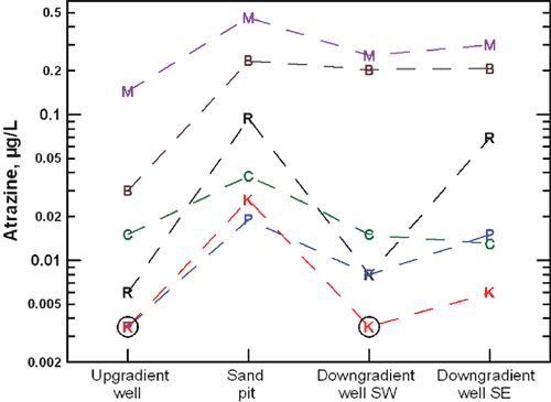
A greater number and generally greater concentrations of pesticides were present at the northwest Wichita sites (20 compounds) than at the southern Wichita sites (nine compounds). Concentrations of pesticides and degradates were usually higher in pit surface waters than in all monitoring-well waters at each site (fig. 3). Concentrations of pesticides and degradates were usually higher in downgradient well waters than in upgradient well waters, and were usually highest in the southeast well (in the general direction of ground-water flow).
Figure 3--Atrazine concentration pattern for water samples at the six pit sites. Each letter represents a site (M--The Moorings, B--Barefoot Bay, R--Ridge Port, C--Cropland, K--Kingston Cove, P--Pine Bay Estates). The bottom axis indicates the sample type (sand pit, surface water, or monitoring well). The circle around the letters P and K for an upgradient well and K for a SW downgradient well indicates an undetectable value (shown as half of the detection limit of 0.007 µg/L). A µg/L (microgram per liter) is equivalent to a part per billion. Dashed lines connect the letters for each site.
Six organic compounds other than pesticides were found in surface waters, and 19 different compounds were detected in well waters at the sites; concentrations for all except four compounds were substantially below primary standards and health advisories. Compounds detected in surface waters were generally different from those detected in ground waters. Ground waters at a site in southern Wichita contained many volatile organic compounds (VOCs); concentrations of three of these exceeded MCLs and five others exceeded the MCLG of zero. They probably entered the ground water not through stormwater runoff but through surface infiltration outside the immediate pit area and likely originated from commercial or industrial point sources. None of these VOCs were detected at the other five sites.
Sediments at the six pits did not have metals contents that exceeded guidelines for probable toxic effects on freshwater ecosystems. However, maximum arsenic, cadmium, chromium, copper, lead, nickel, and zinc observed in some sediments from the pit bottoms exceeded screening levels for threshold or possible toxic effects for freshwater ecosystems. Probable effects are expected to impact ecosystems frequently; possible effects are expected to affect ecosystems rarely. Both are based on statistical measures (EPA National Sediment Inventory). The pesticide chlordane was detected in sediment of one of the northwest Wichita pits. The pesticide DDT, its degradates (DDE and DDD), and polychlorinated biphenyls (PCBs) were found in sediment at the oldest pit (in southern Wichita) at levels exceeding guidelines for threshold toxic effects for freshwater ecosystems.
No inorganic constituents in waters, except arsenic in one well water sample, were found at levels hazardous to human health. Many pesticides were found in surface and ground waters, but none at concentrations hazardous to human health. Many organic compounds other than pesticides were found in surface and ground waters, but none at concentrations hazardous to human health except VOCs that exceeded MCLs in ground waters at a southern Wichita site.
In general, the concentrations of the compounds with expected primary sources from stormwater runoff were substantially below regulated drinking-water criteria and recommended health advisories. Selected metals in sediments at all pits exceeded threshold toxic effects for ecosystems; DDT and PCBs exceeded threshold toxic effects for ecosystems at the oldest pit.
The overall concentration distributions of pesticides and synthetic organics other than pesticides indicate that surface water in the sand pits flows into the ground water in the direction of the ground-water flow at the study sites. The general pattern in iron, manganese, and ammonium ion concentrations in the downgradient well waters relative to the upgradient well and pit waters also supports this. Thus, stormwater runoff containing contaminants enters ground water through the sand pits and impacts ground-water quality. This would probably occur most often when surface runoff into the pits increases the water level in the pit above that of the ground water. Although the evidence shows no human health threat for the use of sand pits for stormwater runoff, the potential for a threat to the aquifer exists if high-contaminant concentrations occurred in the runoff. The task force is currently determining what types of best management practices could reduce the possibility of this threat.
Acknowledgments--Individuals involved in the study included Thomas Huntzinger (formerly) and Lane Letourneau, Division of Water Resources, Kansas Department of Agriculture; Susan Erlenwein, Caroline Hosford, Jo Oliver, and Joe Renfro, Sedgwick County Department of Environmental Resources; Andrew Megrail, Sedgwick County Conservation District; Donald Carlson, Kansas Department of Health and Environment; Michael Dealy, formerly Groundwater Management District No. 2; David Warren and Brian Fisher, the City of Wichita; Wess Gaylon, Wichita Area Builders Association (WABA); Debra Baker, Kansas Water Office; and Lawrence Skelton, formerly KGS. The U.S. Bureau of Reclamation provided the well installation as a service to Kansas; John Gage and Mike McNamee of the Bureau installed the wells. Andrew Ziegler and Larry M. Pope, USGS, coordinated sampling and analysis by the USGS as a contract funded by State and local agencies and the WABA, with a cost share by the USGS. Mark Schoneweis created fig. 1. Rex Buchanan, Bob Sawin, Jim Butler, Lane Letourneau, Don Carlson, and Susan Erlenwein reviewed this circular.
Alluvial aquifer: Unconsolidated, stream-deposited sediments, including sand, gravel, silt, and clay, that hold ground water and yield large amounts of it to wells.
Atrazine: One of the most widely used herbicides in the United States. It is usually applied to kill broadleaf and grassy weeds in crops such as corn and sorghum but also to control weeds along roads and in selected lawns.
Degradate compounds: Chemical compounds produced by the degradation or breakdown of parent compounds by chemical or biochemical processes.
Detected: In chemical analysis, a detected substance is found above the detection limit, which is the lowest quantity that can be confidently distinguished from the absence of that substance (a blank value).
Fungicides: Pesticides used to kill or inhibit fungi or fungal spores.
Herbicides: Pesticides used to kill unwanted plants such as weeds in cultivated crops.
Inorganic constituents: Elements or compounds that are usually of a mineral, not biological, origin.
Insecticides: Pesticides used to kill insects.
Pesticides: Chemical substances used to kill pests such as weeds or insects.
Polychlorinated biphenyls (PCBs): A class of synthetic organic compounds that were manufactured for use in transformers, coolants, lubricants, and other purposes. PCB production was banned in the 1970s due to the toxicity of most of the compounds.
Synthetic organic compounds: Chemical compounds containing carbon that are generated by industrial manufacturing processes.
Total dissolved solids: The total amount of dissolved substances in water.
Volatile organic compounds: Compounds containing carbon that vaporize easily, some of which can be water contaminants when released from improperly disposed chemicals such as cleaning solvents.
MacDonald, D. D., Ingersoll, C. G., and Berger, T. A., 2000, Development and evaluation of consensus-based sediment quality guidelines for freshwater ecosystems: Archives of Environmental Contamination and Toxicology, v. 39, p. 20-31.
Pitt, R. E., Clark, S., Palmer, K., and Field, R., 1996, Groundwater contamination from stormwater infiltration: Ann Arbor Press, Chelsea, MI.
U.S. Environmental Protection Agency, 2006, 2006 edition of the drinking water standards and health advisories: EPA 822-R-06-013, 15 p., http://www.epa.gov/waterscience/criteria/drinking/dwstandards.pdf.
Vogel, J. R., Majewski, M. S., and Capel, P. D., 2008, Pesticides in rain in four agricultural watersheds in the United States: Journal of Environmental Quality, v. 37, p. 1,101-1,115.
Whittemore, D. O., 2007, Water-quality effects of stormwater runoff into sand pits on ground water in Sedgwick County, Kansas--Phase I: Kansas Geological Survey, Open-file Report 2007-9, http://www.kgs.ku.edu/Hydro/Publications/2007/OFR07_9/index.html.
Whittemore, D. O., 2008, Water-quality effects of stormwater runoff into sand pits on ground water in Sedgwick County, Kansas--Phase II: Kansas Geological Survey, Open-file Report. 2008-4, http://www.kgs.ku.edu/Hydro/Publications/2008/OFR08_4/index.html.
![]()
![]()
![]()
Kansas Geological Survey, Public Outreach
Comments to webadmin@kgs.ku.edu
Web version August 2009
http://www.kgs.ku.edu/Publications/PIC/pic29.html