Kansas Geological Survey, Open-file Report 2014-2
KGS Open File Report 2014-2
Final Report to the Kansas Water Office
March 2014
The purpose of this research was to investigate the characteristics of the High Plains aquifer affecting water availability with depth by recovering and analyzing a complete core of aquifer sediments in Haskell County, Kansas. The focus was on calibrating lithologic descriptions derived from driller's logs by comparison with intact sedimentary strata in long continuous cores.
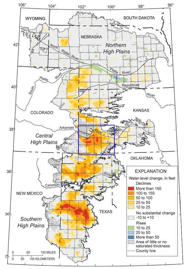
The High Plains aquifer is one of the largest freshwater aquifers in the world and accounts for nearly 30% of all groundwater withdrawals in the United States (Dugan and Sharpe, 1996). Intensive development of the aquifer for agriculture began in the 1940s and now supports an estimated 12.7 million acres of irrigated land in the states of Kansas, Colorado, Nebraska, New Mexico, Oklahoma, South Dakota, Texas and Wyoming (McGuire, 2009; Fig. 1). Groundwater withdrawals in some areas have greatly exceeded local rates of recharge resulting in historic declines in water levels and growing concerns for long-term sustainability (Young and Buddemeier, 2002).
Figure 1--Historic water level declines in the High Plains aquifer. Blue box outlines general location of study area. Modified from McGuire (2009).
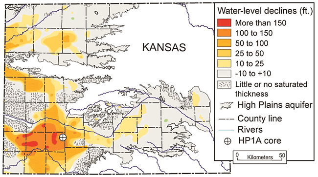
In Kansas, the High Plains aquifer is historically thought to consist of the Neogene Ogallala Formation and overlying, hydraulically-connected Quaternary deposits. The Ogallala Formation is the primary source of potable and irrigation waters in the Great Plains and drives much of the region's economy. Measured water-level declines of >200 feet from predevelopment levels are common in southwestern Kansas (McGuire, 2009; Fig. 2) where the usable lifetime of the aquifer at present rates of withdrawal ranges from less than 25 years to greater than 250 (Wilson, 2007). The subsurface data on the Ogallala-High Plains aquifer indicate it is highly variable in saturated thickness, sediment composition, and aquifer properties. Two wells in different locations with the same saturated thickness, for example, can have very different yields, drawdowns, and estimated useable life left in the aquifer.
Figure 2--Water level changes in the High Plains aquifer since the 1950s, and location of the HP1A core. Modified from McGuire (2009).
Management of the remaining groundwater resource is critical and will be achieved most effectively by using numerical modeling of groundwater flow to predict hydrogeological response to different management strategies. The predictive power of such models depends on accurate characterization of the hydrogeologic properties of aquifer materials and their stratigraphic framework (Anderson and Woessner, 1992). These properties control aquifer geometries and hydrogeologic relationships and are derived from the formative processes and depositional histories of water-bearing and confining strata.
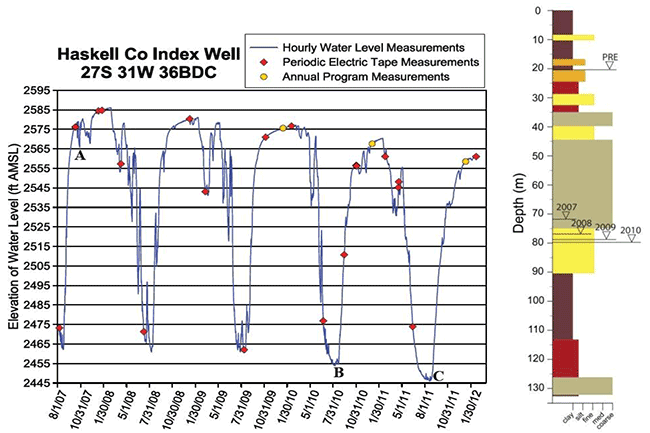
On April 12, 2011, the Kansas Geological Survey (KGS) commenced coring operations of the first core (HP1A) in Haskell County in southwest Kansas (Fig. 2). An intact core from this location would tie in with ongoing and multi-year groundwater monitoring studies in the area (Stotler, 2011). The Haskell Index Well is located approximately 100 meters northwest of the HP1A core and is instrumented with a pressure transducer and telemetry system that collects a continuous record of water level changes and barometric pressure (Fig. 3). This is an area of high density water use, as defined by the water pumped from the aquifer per unit of land and drawdowns of 130 feet or more have been recorded during the irrigation season. In addition, the aquifer at this location appears to have two separate aquifer units, with the lower one semi- confined and the upper unit responding as a phreatic water table aquifer.
Figure 3--Haskell County Index well hydrograph, (left) and drafted section from drill cuttings from same well showing falling maximum water table heights--total data run 8/1/07 to 2/21/12; modified from Butler et al., 2012, High Plains Aquifer Calibration Monitoring Well Program.
In the unsaturated zone above the water table, an Acker hollow-stem auger drill rig was used to split-spoon sample aquifer materials in 2-foot sections of plastic liner. The water table was reached on August 1, 2011 at a depth of 73.8 m, at which point sample collection with the hollow-stem auger rig was no longer feasible. Coring operations were continued on August 7, 2011 using a S-27 rotary-vibratory drill rig. This rig is able to retrieve high-quality continuous core from unconsolidated and saturated intervals. Sediment and pore fluid samples are pneumatically held within the core barrel by an Aqualock piston sampling system and then extracted from the core barrel into 1 meter long plastic liners. Plastic-lined core samples were capped on-site and stored in crates before transport back to KGS and further analyses.
HP1A in Haskell County, KS, is the first and deepest intact core of the High Plains Aquifer (HPA) ever attempted. Approximately 98 m of this core is complete with ~89% recovery. Upon retrieval of the HP1A core back to KGS facilities, a series of geophysical and geochemical analyses were conducted. In particular, stable isotopic chemostratigraphy and preliminary U/Pb dates of volcanogenic zircons from the HP1A core suggest an older and more complex depositional history of the High Plains Aquifer System than previously thought.
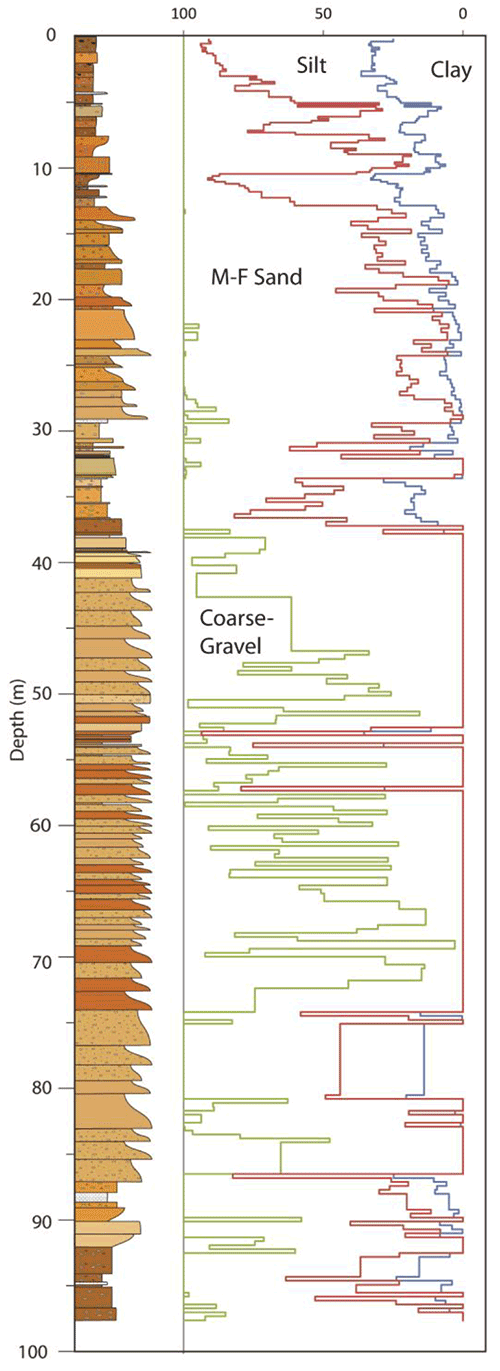
Lithologic logging of the core including estimating grain size, bedding features, colors, mineralogy, and noting pedological and biological features (Fig. 4). Particle size analyses of HP1A core at the KGS Geoarchaeology and Paleoenvironmental Research Laboratory. The upper 12 meters of the HP1A core is composed mostly of silt and clay dominated strata. According to KU Professor of Geoarchaeology, Rolfe Mandel, these likely comprise the Quaternary Loess-Paleosol Sequence recognized in upland deposits throughout Kansas and the North American High Plains. Given the OSL dates generated from within this interval, these sediments most likely represent the Loveland Loess and possibly paleosols of the Gilman Canyon Pedocomplex (Welch and Hale, 1987).
Figure 4--Drafted section of the HP1A core with grain size distributions as determined by particle size analysis at the KGS Geoarchaeology and Paleoenvironmental Research Laboratory.
Strata below the Quaternary Loess Sequence from 12 m to ~40 m depth is dominated by fine- to medium-grained sands interbedded with thin calcareous beds of silt showing evidence of soil development such as rhizoliths and invertebrate burrows. Very coarse-grained sands and gravels are common below 40 m to a depth of ~87 m and likely represent fluvial channel deposits. A meter-thick caliche layer was encountered at ~88 m, below which are fine- to medium-grained sands and sandy paleosol intervals.
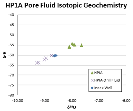
Eighty-seven (87) carbonate nodules were sampled for δ13C and δ18O analysis on the Kiel Device and 151 bulk sediment samples were collected for organic carbon on the Elemental Analyzer (EA) at the W.M. Keck Paleoenvironmental and Environmental Stable Isotope Laboratory (KPESIL). Chemostratigraphic records of the δ13C of sedimentary organic matter show an expected long-term Cenozoic temporal trend from lower values more characteristic of a C3 paleoflora, to higher values more characteristic of C4 paleoflora as per Fox and Koch (2003). However, the timing of this transition in the core is uncertain (Fig. 5). The majority of isotopic values recovered are strongly negative (-22 to -27‰) to depths as high as shallow as 3.5 m in depth and suggests a largely C3 dominated paleoflora for the majority of the depositional history of the core. In addition, initial analyses of pore fluids collected via the Rotosonic drill and extracted by Professor Randy Stotler show that there is a distinct isotopic difference between the upper (HP1A) and lower (HP1A-Drill Fluid and Index Well) aquifers at the HP1A location (Fig. 6). The pore water from the aquitard will provide important information regarding connectivity of the upper and lower aquifers.
Figure 5--Drafted section of the HP1A core with δ13C of sedimentary organic matter (left column) and δ13C and δ18O of carbonate nodules (right columns).
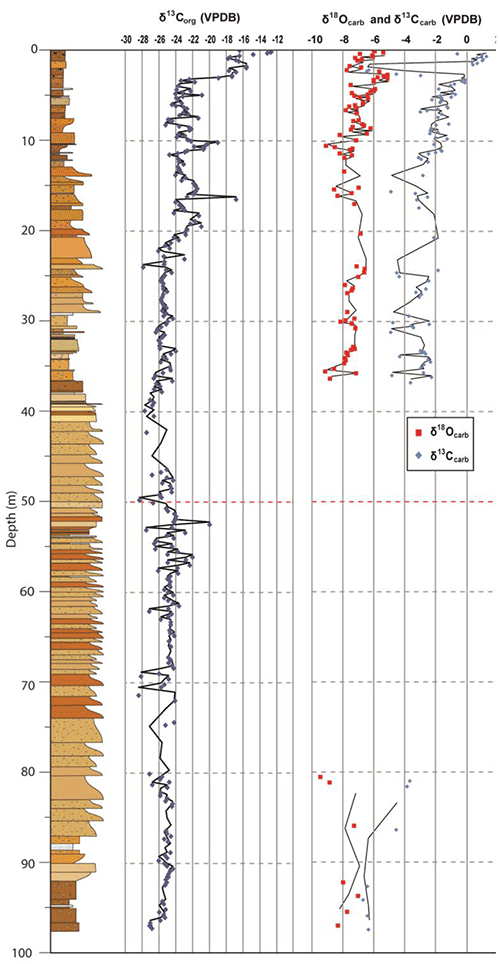
Figure 6--Stable isotopic analyses of pore fluids captured at depth via the Rotosonic drill rig showing that ground water from the upper (triangles) aquifer is isotopically distinct from that of the lower aquifer (crosses).
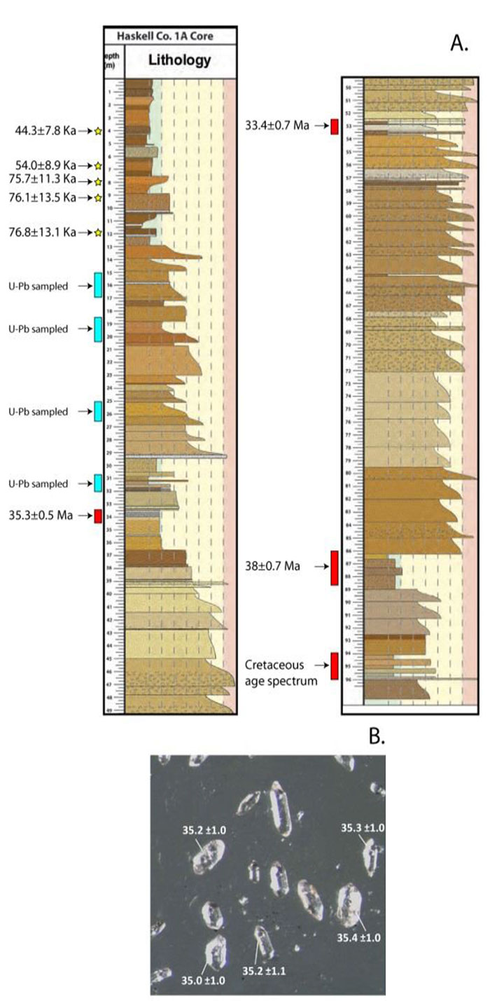
Six samples from the upper 12 m of the HP1A core were sampled and shipped to Utah State University Optically-Stimulated Luminescence (OSL) Laboratory for dating by Tammy Rittenour of assumed Quaternary loess and paleosol sections identified by KU Professor of Geoarchaeology, Rolfe Mandel. The resulting age spectra confirmed that these deposits were Late Pleistocene in age and ranged from 76.8±13.1 Ka at ~12 m depth to 44.3±7.8 Ka at ~4 m depth (Fig. 7). Eight samples from suspected mature paleosols from the depths below the Quaternary section were collected for heavy liquid separation and U/Pb dating of volcanogenic zircons at the University of Kansas LA-ICP-MS Geochronology Laboratory under the direction of Professor Andreas Möller and laboratory manager Josh Feldman (Fig. 6). Paleosols are condensed stratigraphic intervals in terrestrial stratigraphic successions, and offer the potential to produce stratigraphically-useful radiometric dates from volcanogenic zircons. The zircon populations from these selected intervals have been sorted to analyze clear, elongate euhedral grains that are indicative of primary air fall tephra that was subsequently worked into the paleosol matrix via pedoturbation. Four preliminary U/Pb dates from zircons via LA- ICP-MS from depth ranges of 89 m to 33.5 m in the HP1A core suggests that the contained paleosols have depositional ages ranging from 38±1.4 Ma to 33.4±0.7 Ma. An additional four samples were collected from the interval between 12 and 33.5 m and are currently undergoing analysis. These new geochronologic results are being tested further, but if true, they suggest Eocene to Oligocene aged deposits equivalent in age to the White River Group in Nebraska and previously unknown from Cenozoic strata in Kansas.
Figure 7--Graphic log from HP1A core as of showing A. interpreted Quaternary loess sequences with OSL dates (stars) and U/Pb dates generated from select zircon crystals at deeper depths (red bars). Blue bars indicate intervals from which additional zircon samples have been collected and are currently being processed for U/Pb analyses. B. inset picture of high graded volcanogenic zircon crystals from the 33.5 to 34.5 m interval and their associated U/Pb dates.
Financial is appreciated from a Kansas Water Office Grant KAN0066607 to Ludvigson and Smith, NSF Grant EAR-1023285 to Smith, Ludvigson, Doveton (KGS), and USGS STATEMAP Grants for the mapping of Haskell County to Ludvigson et al. (2011-2013). Special thanks to Jay and Jarvis Garetson of Garetson Brothers Farms, the Kansas Geological Mapping Advisory Committee, and to the KGS scientific staff, students, and administration.
Anderson, M.P., and Woessner, W.W., 1992, Applied Groundwater Modeling: Simulation of Flow and Advective Transport: New York, Academic Press, 381 p.
Dugan, J.T., and Sharpe, J.B., 1996, Water-Level Changes in the High Plains Aquifer--Predevelopment to 1994: U. S. Geological Survey, Water-Resources Investigations Report 95-4208. [available online]
Fox, D.L., and Koch, P.L., 2003, Tertiary history of C4 biomass in the Great Plains, USA: Geology, v. 31, p. 809-812.
McGuire, V.L., 2009, Water-level changes in the High Plains aquifer, predevelopment to 2007, 2005-2006, and 2006-2007, U.S. Geological Survey, Scientific Investigations Report 2009-5019, 9 p. [available online]
Stotler, R., Butler, Jr., J.J., Buddemeier, R. W., Bohling, G.C., Comba, S., Jin, W., Reboulet, E., Whittemore, D.O., Wilson, B.B., 2011. High Plains Aquifer Calibration Monitoring Well Program: Fourth Year Progress Report, Kansas Geological Survey, Open-file Report 2011-4, 185 p. [available online]
Welch, J.E., and Hale, J.M., 1987, Pleistocene loess in Kansas--status, present problems, and future considerations; in, Quaternary Environments of Kansas, W.C. Johnson, ed.: Kansas Geological Survey, Guidebook Series 5, p. 67-83. [available online]
Wilson, B.B., 2007, Ground-water levels in Kansas: A briefing to the Kansas Legislature House Agriculture and Natural Resources Committee, Kansas Geological Survey Open-File Report 2007-1, 15 p. [available online]
Young, D.P., and Buddemeier, R.W., 2002, Climate Variation: Implications of Long-Term Records and Recent Observations, Kansas Geological Survey Open File Report 2002- 25E, 72 p.. [available online]
The following fourteen abstracts of presentations at professional meetings and one Master of Science thesis have been published as a result of this funded research:
Harlow, R.H., Ludvigson, G.A., Smith, J.J., Doveton, J.H., and Petronis, M., 2012. Stratigraphic, Chemostratigraphic, and Geochemical Investigations of the First Intact Drill Core of the High Plains Succession in Western Kansas. Geological Society of America, Abstracts with Programs 44(7):585.
Harlow, R.H., Ludvigson, G.A., Smith, J.J., Doveton, J.H., Petronis, M., Gonzalez, L.A., 2013. Employment of non-traditional techniques to improve stratigraphic correlation of the High Plains Succession and their applications for future groundwater management. 10th Annual Capitol Graduate Research Summit, Topeka, KS.
Harlow, R.H., Ludvigson, G.A., Smith, J.J., Doveton, J.H., and Murphy, L.R., 2013. Evolution of the Neogene High Plains Succession depositional history through paleoclimatic and alluvial vertical sequence analysis: Southwestern Kansas: 2013 Annual Meeting of the Society for Cenozoic Research (TerQua), Lawrence, KS, Programs and Abstracts, p. 12.
Harlow, R.H., 2013. Depositional and Paleoclimatic Evolution of the Cenozoic High Plains Succession, Haskell Co., Kansas: Master of Science Thesis, Department of Geology, The University of Kansas, Lawrence, Kansas, 115 p.
Layzell, A., Ludvigson, G.A., Mandel, R., and Smith, J.J., 2014. Investigations of the litho-and soil-stratigraphy of Plio-Pleistocene strata in the Cimarron River Valley, southwestern Kansas. Geological Society of America, North-Central Section Meeting, Abstracts with Programs.
Ludvigson, G.A., Smith, J.J., Harlow, R.H., Doveton, J.H., Mandel, R.D., Gonzalez, L.A., Zeigler, K.E., Petronis, M.S., Möller, A., Feldman, J., Stotler, R., and Rittenour, T.M., 2013. A scientific drilling program in the Cenozoic strata of the High Plains in western Kansas. 2013 Annual Meeting of the Society for Cenozoic Research (TerQua), Lawrence, KS, Programs and Abstracts, p. 16.
Ludvigson, G., Smith, J.J., Joeckel, R.M., Möller, A., and Feldman, J., 2014. Development of a scientific drilling program in Cenozoic strata of the Great Plains in Kansas and Nebraska. Geological Society of America, North-Central Section Meeting, Abstracts with Program.
Katz, B.S., Stotler, R.L., Hirmas, D.R., Whittemore, D.O., Butler, J.J., Smith, J.J., and Ludvigson, G.A., 2013. Implications of δ18O and δ2H stable isotopes for recharge to the High Plains Aquifer, northwestern Kansas: Geological Society of America, Abstracts with Programs, v. 45, no. 7., p. 350.
Smith, J.J., Ludvigson, G.A., Doveton, J.H., and Petronis, M.S., 2010. Inauguration of a scientific drilling program investigating the lithology and stratigraphy of Neogene strata of the Central High Plains Aquifer in western Kansas. Geological Society of America, Abstracts with Programs, v. 42, no. 5, p. 431.
Smith, J.J., Ludvigson, G.A., Harlow, R.H., Doveton, J.A., Zeigler, K., Petronis, M., Möller, A., Feldman, J., Stotler, R., and Rittenour, T.M., 2013. Paleogene Strata of the High Plains in western Kansas? Preliminary radiometric dates from volcanogenic zircons in mature paleosols. Geological Society of America, Abstracts with Programs, 45(7):478.
Smith, J.J., Ludvigson, G. Möller, A., Feldman, J., Harlow, H., Doveton, J., Rittenour, T., and Platt, B., 2014. Developing a paleosol geochronometer: Examples from Cenozoic strata of the High Plains of the western United States: American Association of Petroleum Geologists Annual Convention.
Trevino, S.F., Zeigler, K.E., Petronis, M., Smith, J.J., Ludvigson, G.A., and Doveton, J.H., 2013. New magnetic polarity data from the High Plains-Ogallala Drilling Project core HP1A: a preliminary magnetostratigraphy from the Eocene-Oligocene White River Group, southwestern Kansas. Geological Society of America, Abstracts with Programs, 45(7):135.
Trevino, S.F., Zeigler, K.E., Petronis, M., Smith, J.J., Ludvigson, G.A., and Doveton, J.H., 2014. Developing a refined magnetostratigraphy for the White River Group and Ogallala Formation in southwestern Kansas: Preliminary results from the High Plains-Ogallala Drilling Project. Geological Society of America, North-Central Section Meeting, Abstracts with Program.
Zeigler, K.E., Petronis, M.S., Smith, J.J., Ludvigson, G.A., and Doveton, J., 2012. The Neogene Ogallala Formation in southwestern Kansas and northeastern New Mexico: Preliminary magnetostratigraphic analyses for the High Plains-Ogallala Drilling Program. American Geophysical Union Fall Meeting.
Zeigler, K.E., Petronis, M.S., Smith, J.J., Ludvigson, G.A., and Doveton, J., 2012. Preliminary Magnetostratigraphic Analyses of the Neogene Ogallala Formation in southwestern Kansas and northeastern New Mexico for the High Plains-Ogallala Drilling Program. Geological Society of America, Rocky Mountain Section - 64th Annual Meeting, Abstracts with Programs, 44(6).
To read this report, you will need the Acrobat PDF Reader, available free from Adobe.
Kansas Geological Survey
Placed online May 21, 2014
Comments to webadmin@kgs.ku.edu
The URL for this page is http://www.kgs.ku.edu/Publications/OFR/2014/OFR14_2/index.html