Kansas Geological Survey, Open-file Report 2005-13
by
Shawn Salley, Michael Morales, and Richard O. Sleezer
Earth Science Department
Emporia State University
KGS Open File Report 2005-13
May 2005
Hamilton Quarry is a small area in Greenwood County, Kansas, widely known for its exceptional abundance, diversity, and preservation of plant, animal, and microorganism fossils of Late Pennsylvanian age. The deposits are associated with valley fill and nearshore deposits associated with a paleochannel that incised into two formations, the Topeka Limestone and Calhoun Shale, of the Shawnee Group. The exact age of the channel is unknown due to the erosion of overlying beds and poor surface exposure. The purpose of this investigation was to create a member level geologic map of the channel deposits and surrounding rock units in the quarry and adjacent vicinity, and to compare the results to published information. Results of the investigation of the Hamilton Quarry area revealed the age of the paleochannel to be younger than the Hartford Limestone Member of the Topeka Limestone, and probably older than the Severy Shale. Strata other than the Hamilton deposits exhibit layer cake stratigraphy and can be seen in outcrop along the creek running through the central portion of the study area. This investigation has raised questions about the accuracy of the recently published geologic map of Greenwood County (Merriam, 1999). Corrections are proposed in this study for apparent misidentifications of certain rock units in Merriam's map. Although previous geologic maps of the Hamilton Quarry area have been produced (Myers, 1982; Fahrer, 1991; Cunningham, 1993a), this is the first investigation at the member level.
The large map for this report is available as an Acrobat PDF file (1.1 MB).
Please note: Hamilton Quarry is owned by Emporia State University. Those wanting to visit or collect at the site need to request permission from Dr. Michael Morales (moralesm@emporia.edu), ESU Assoc. Professor and Geology Museum Director.
The fossils of Hamilton Quarry have been collected, documented, and studied in the past with only casual reference to the regional geology. The fossiliferous channel deposits at the quarry are generally considered to be Virgilian (Late Pennsylvanian) in age, although the plants seem to imply an Early Permian age. The specific time when the Hamilton paleochannel cut down through older rock units and then deposited fluvial sediments is not precisely known. Some have concluded that the downcutting and valley fill occurred during the time of deposition of the Topeka Limestone or Calhoun Shale (Mapes and Mapes, 1988). In the geologic map of Greenwood County (Merriam, 1999), however, the Hamilton deposits are shown as Ervine Creek age, which is older then both the Topeka and Calhoun. This classic fossil locality is now a designated Emporia State University (ESU) natural area. The desire by ESU for more precise information about the age and geographic locations of individual rock units at the quarry prompted a need for a detailed member level geologic map.
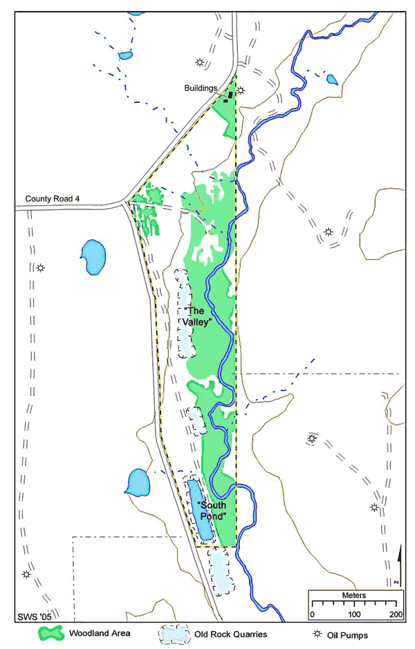
Hamilton Quarry is in east-central Greenwood County, Kansas (Figure 1). It is an abandoned rock quarry, owned and managed by Emporia State University. The bedrock is all within the Virgilian Stage, Upper Pennsylvanian Series, Pennsylvanian System, and is part of the Osage Cuestas Physiographic Province. The bedrock in this area exhibits layer cake stratigraphy with a shallow dip to the northwest. An incised paleovalley cuts through the middle of the study area. Through erosion of the surrounding strata, a modern creek has carved out the eastern flank of the paleovalley fill deposits. Outcrops of the Topeka Limestone and the Calhoun Shale occur in cliff and bench topography along the eastern portion of the map. The field investigation and geologic mapping was conducted in part of sections five and eight of Township 24 South, Range 12 East. Access to this area is along Greenwood County Road 4, three miles east of Hamilton, Kansas.
Figure 1. Hamilton Quarry Study Area.
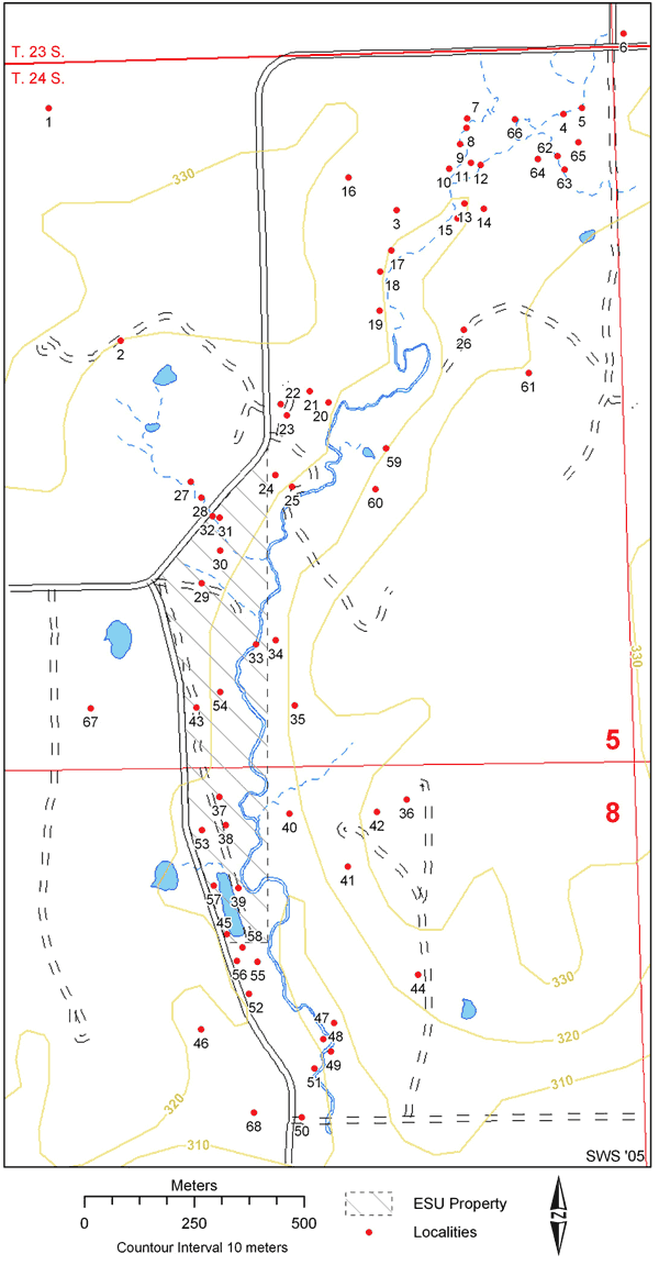
The field work on which this report is based was conducted by graduate ESU earth science graduate student Shawn Salley during parts of 2003 and 2004. Valuable field knowledge about the study area was provided by Paul L. Johnston and Thomas E. Bridge. Field reconnaissance of specific sites in the study area was documented by measuring sections, taking pictures of outcrops, and collecting rock and fossil samples. The sites are illustrated in Figure 2, and a table of the documented sites is in the Appendix 1. Outcrop sites were identified and marked using Global Positioning System (GPS) technology, and also recorded on a field map, based on the Virgil 7.5-minute topographic map (USGS, 1969), and a field aerial photograph based on the one meter resolution Digital Orthophotographic Quarter Quadrangles (DOQQ).
Figure 2. Sites within the Hamilton Quarry study area. The localities are discussed in the report and are referenced in Appendix 1. The coordinates for each locality are also referenced in Appendix 1. Specimen numbers do onot correspond to locality number.
Laboratory work included translating field data and published information into the member level geologic map of the Hamilton Quarry area. Known outcrops were transferred from the field map and photograph to the GIS via heads-up digitizing using Arcview 3.3. Data from all previous geologic investigations were scanned, and the resulting images were registered and rectified for overlay analysis using GIS. The rock-unit boundaries were interpreted from the known outcrop points by tracing between the field sites located during field reconnaissance and lab analysis of aerial photography. Contacts that were not visible were inferred from topographic analysis and the region dip. Because exposure is poor, to define the coverage of the channel, the adaptation of Cunningham's (1993a) extent is used. His results are based on coring of the bedrock performed by the Kansas Geological Survey in the summer of 1989 (Leonard, 1991). Leonard's interpretation of the cores was also used for unit thickness where a full member or formation outcrop was not available. The elevations used to calculate the dip of the bedrock were taken from the Virgil 7.5 minute topographic map (USGS, 1969) at the most prominent bed in the study area, i.e., the base of the Hartford Limestone Member of the Topeka. Rock samples were photographed, and selected samples were sawed using a diamond blade rock saw.
The lithology was mapped at three levels of certainty. The levels of confidence regarding the boundaries between members and formations are, in decreasing certainty: observed, inferred, and approximated. The observed boundaries are represented with a thick solid line. Observed contacts should be interpreted as visible distinct outcrops in aerial imagery with field support of identified lithology. All observable contacts were placed where fossil or lithologic evidence supports a definite boundary between members or formations. Inferred contacts were represented by short dashed lines and designate an intermediate level of confidence. These contacts were understood as boundaries that may be observable in imagery, but cannot be identified with certainty at the study site. These lines were drafted at these locations with account to the bedrock dip and other limiting field evidence. Approximated contacts, which are shown on the map as longer, thin dashed lines, show boundaries that have a lower level of confidence. This is due to poor field and/or aerial photographic support to warrant a higher level of precision. However, an approximated boundary should not be viewed as an ambiguous interpretation, but rather the most-likely contact within the context of the regional bedrock dip and limiting field evidence.
The rock strata of Hamilton Quarry are mapped based on lithology and identification of outcrop units. The regional dip is to the north-west at approximately 8.7 meters per kilometer (46 feet per mile). Much of the property is covered with vegetation, and much of the surface rock is not in situ due to lag or backfill from the quarry operations. Also, over the past 40 years of fossil collecting, good exposures of the rock units, primarily the fossiliferous limestones above the conglomerate, were removed or greatly disturbed. Strata present in the study area include the Deer Creek Limestone, Calhoun Shale, Topeka Limestone, Severy Shale, and the informally recognized Hamilton channel deposits. No complete formation or member is exposed in one continual outcrop at Hamilton Quarry. Thicknesses of the geologic formations and members are interpreted based on cores from Leonard (1991). The rock units are described below in ascending order.
Shawnee Group--The Shawnee Group is composed of four predominantly limestone formations and three mostly shale formations. Only the upper two limestone formations and an intervening shale formation are present in the study area. They are the Deer Creek Limestone, the Calhoun Shale, and the Topeka Limestone.
Deer Creek Limestone--The Deer Creek Limestone is a persistent, escarpment-making formation composed of three limestone members and two shale members (Zeller, 1968). They are the Oskaloosa Shale, Rock Bluff Limestone, Larsh and Burroak (or Larsh-Burroak) Shale, and the Ervine Creek Limestone members. The two formations observable and described in the study area are represented by only the two uppermost members, the Larsh-Burroak Shale and the Ervine Creek Limestone.
Larsh-Burroak Shale--This shale is distinctive and serves as a marker bed in the area. The Larsh-Burroak Shale is a black-fissile shale found in the southern part of the study area only along the creek. There is no observable outcrop in the area where a total thickness can be measured. Leonard (1991) from core descriptions gives a give a thickness of approximately 1 meter. Small bivalves and inarticulate brachiopods can be identified in the lab. A creek south of the study area, in which this shale outcrops, has been named Slate Creek due to this shale's black slate-like appearance.
Ervine Creek Limestone--Zeller (1968) describes two distinct beds for this member, a lower wavy bedded limestone and an upper massive limestone with variable lithology. The two beds can not be distinguished easily at Hamilton Quarry. In the study area the Ervine Creek Limestone is a 1-2 meter thick bluish to light gray fine-grained wackestone. Fusulinids, phylloid algae fragments, and brachiopods are diagnostic fossils for field identification. Weathered Ervine Creek Limestone appears pale-yellow to orange. East of the south pit, this limestone member can be seen at the creek bottom and outcrops better downstream. The Ervine Creek has a sharp lower contact on top of the Larsh-Burroak Shale (Leonard, 1991).
Calhoun Shale--At Hamilton Quarry, the Calhoun Shale has a thickness between 10 and 11.5 meters. This shale formation has four distinct lithologic intervals. They include: a lower platy bluish gray shale, a sandy shale interval with micaceous sandstone bed, a skeletal limestone, and an upper shale member. Little attempt will be made in this report to document the high variability within short distances found in the Calhoun Shale. The lower shale member is transgressive shale between the marine Ervine Creek and the deltaic deposits of the upper micaceous sandy deposits. In the lower section of this shale, there are brachiopods, crinoids, and bryozoans, while the upper section is mostly unfossiliferous with scattered plant fragments. This lithologic unit ranges between 2.7 and 3.5 meters (Leonard, 1991). Directly overlying the lower shale is the sandy interval, the lithology of which ranges from sandy shale to micaceous sandstone. Plant fossils are common in this interval, mostly stems and pinnules and Calamites. This sandy interval includes the brown shale above the sandstone. Although the sandstone bed is generally a meter thick, the entire sandy interval is 4 to 7 meters (Leonard, 1991). The limestone interval overlies the sandy interval. This is commonly a fossiliferous limestone and ranges from a coated grain wackestone to skeletal grainstone. Identification of this bed is problematic in the field due to its similarity to the Hartford Limestone, e.g., both units contain coated grains and the chambered sponge Amblysiphonella. Fossils in the limestone include bivalves, coated grains, crinoids, sponges, brachiopods, foraminifera, bryozoans, and fusulinids. Immediately below this limestone there is a gradational boundary from highly fossiliferous sandy shale with abundant plant material. The limestone bed ranges in thickness from 0.3 to 1.5 meters. The upper lithologic interval is a silty to sandy mudstone. It is poorly exposed at Hamilton Quarry. Leonard (1991) describes the unit as sparsely fossiliferous with plant fragments, burrows, and Lingula. This interval has a thickness range of 2.4 to 3.4 meters.
Topeka Limestone--The Topeka Limestone is named for exposures near Topeka, Kansas. In the northern part of the state at Topeka, there are nine developed members (Zeller, 1968): the Hartford Limestone, Iowa Point Shale, Curzon Limestone, Jones Point Shale, Sheldon Limestone, Turner Creek Shale, DuBois Limestone, Holt Shale, and the Coal Creek Limestone. At Hamilton Quarry, only the lower three members of the Topeka Limestone can be identified. The upper units are termed here as undifferentiated Topeka Limestone. The total formation thickness is approximately 11 meters (Leonard, 1991).
Hartford Limestone--This formation is the lowest and therefore oldest member of the Topeka Limestone. In the area of Hamilton Quarry and to the north, the Hartford becomes unusually thick and deviates from it typical lithology. The study of limestone buildups is discussed by Heckel and Cocke (1969) in what are considered as marine algal banks, and the Hartford Limestone algal-mound complex is described in greater detail by Silfer (1986a, 1986b). There are four macrofacies described by Silfer, all of which can be identified at Hamilton Quarry. They are a basal skeletal facies with diverse marine fauna; the algal facies of interlayered phylloid algae; a mound capping sequence with algal-coated skeletal fragment; and fusulinid facies. The oldest facies is the typical Hartford Limestone, which is characterized by the chambered sponge Amblysiphonella. There are also brachiopods, bryozoans, crinoids, and the encrusting algae Ottonosia in this lower lithologic unit. This unit is dark-gray and weathers gray to yellow-brown. The algal facies is primarily comprised of interlayered phylloid algae. In the Hilltop Quarry north of Hamilton Quarry, this facies appears to have a large wave-like appearance. Heckel and Cocke (1969, p. 1061) informally called these megaripples. This same type of lithology is identified in the Hamilton Quarry area (seen at sites: 11, 12, 14, 17, 18, and 19 on Figure 2). The measured wavelength is 3.5 to 4.5 meters, and the amplitude is 0.3 to 0.5 meters. This unit is a light-gray micritic limestone that weathers light brown. Although not observed during this investigation this same facies has a mottled brecciated appearance at other outcrops (Ezerendu, 1986). The next two units are considered a capping sequence for the marine algal bank and can be observed in most marine algal complexes of the Pennsylvanian (Heckel and Cocke, 1969). The lower of the two is an oncolite lithology of almost entirely algal-coated skeletal fragments, and the upper a fusulinid foraminifera lithology comprised primarily of recrystalized lime mud. These two facies are not clearly defined, but can be inferred from the KGS core and seen in outcrop. The total thickness of the Hartford Limestone at Hamilton Quarry is between 4 to 5 meters. There is a sharp lower contact of the Hartford on top of the Calhoun Shale.
Iowa Point Shale--This shale member cannot be seen in outcrop. It is a relatively thin shale member that was recovered in two of the 1988 cores. The thickness of the Iowa Point shale is approximately 1.3 meters (Leonard, 1991). Localized coal streams are seen at some locations (Zeller, 1968), but was not found in any of the KGS cores (Leonard, 1991). The Iowa Point in the study area has three general lithologies: a lower sandy shale, a middle wackestone, and an upper calcareous shale. Schultz (1985) describes the many environments of the Iowa Point Shale which include: estuarine to floodplain to lacustrine deposits.
Curzon Limestone--The Curzon Limestone is similar to the normal sequence of the Hartford Limestone. The Curzon, however, is distinctive for its orange weathered appearance. Where observed, it consists of sandy to argillaceous wackestone. There are several marine fossils including fusulinids, brachiopods, crinoids, bryozoans, and echinoids. Unlike the previously described units, the Curzon does not cropout along the creek bed. Two KGS cores (KGS #2 Ulrich and KGS #3 Ulrich) contain the entire member. The thickness obtained in these cores ranges from 3 to 4.7 meters (Leonard, 1991).
Undifferentiated Topeka--The upper units of the Topeka Limestone are poorly exposed in the study area. In Greenwood County, the Topeka also becomes highly variable (Bridge, 1988). The Curzon Limestone is a bench-forming limestone that can be traced across Greenwood County. For this reason the upper units generally are not present due to recent surface erosion. Descriptions of the upper units are present in Core U2 (Leonard, 1991).
Severy Shale--This formation is poorly exposed and inferred to be along the hilltop at the eastern portion of the study area. There is no observable outcrop of the Severy Shale within this study. The location is inferred based upon previous investigations (Fahrer, 1991 and Cunningham, 1993a) and the dip of the bedrock. The Severy lies unconformably on top of the Topeka Limestone (Zeller, 1968). This is confirmed in an abandoned quarry 4 km to the northeast of the study area. White (1986) interpreted the deposition of the Severy Shale as a dynamic environment where high energy channel sandstones were interbedded with low energy fossiliferous clay and mudstones containing abundant plant debris. This deposition is similar to the Calhoun Shale which was observed in better outcrops along the creek. The Severy is the lowest formation in the Wabaunsee Group.
Differences were found between the geologic map of Greenwood County (Merriam, 1999) and the map produced as a result of this study (Figures 3 and 4). They occur primarily in the area of sections 5, 6, 7, and 8 of Township 24 South, Range 12 East and Section 32 of Township 23 South, Range 12 East. Ross and Collins (2002) stated that the county map should not be used at a scale larger than 1:24,000, even though it is published at a scale of 1:50,000. But if the map is displayed at either scale, there are significant inaccuracies, primarily in the two points discussed below.
Figure 3. Portion of the Greenwood County Geologic Map (Merraim, 1999). Symbols indicate: ![]() : Shawnee Group,
: Shawnee Group, ![]() : Wabaunsee Group, EC: Ervine Creek, C: Church Limestone.
: Wabaunsee Group, EC: Ervine Creek, C: Church Limestone.
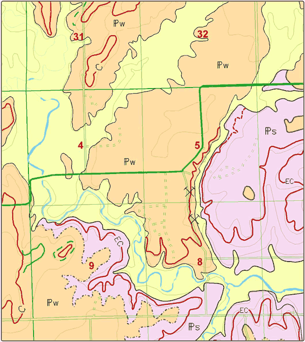
Figure 4. Revisions of the Greenwood County Geologic Map. Symbols indicate: ![]() : Shawnee Group,
: Shawnee Group, ![]() : Wabaunsee Group, EC: Ervine Creek, C: Church Limestone.
: Wabaunsee Group, EC: Ervine Creek, C: Church Limestone.
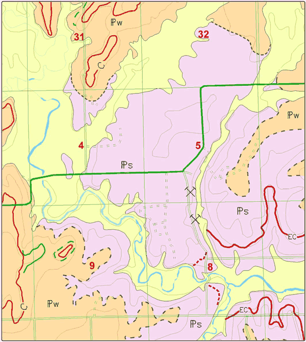
1. The misidentification, in sections 5, 6, 7, 8, of the Shawnee and Wabaunsee groups and of the contact between them is the most obvious error on the county map. The lowermost formation of the Wabaunsee Group, the Severy Shale, lies disconformably on the Topeka Limestone (Zeller, 1968). Poor exposure and the gradual rolling topography in these sections can lead to the misinterpretation that the Severy Shale covers the area in the above mentioned sections. However it is known from the analysis of cores in Leonard (1991) and Cunningham (1993a) that the area includes lower members of the Topeka Limestone. The post-Hartford erosion, caused by downcutting of the Hamilton paleochannel, removed the rock units west of the unnamed creek flowing through the center of sections 5 and 8. However, the prominent escarpment in the eastern halves of sections 5 and 8 shows no evidence of erosion by this event. Given a calculated dip in bedrock of approximately 8.7 meters per kilometer (46 feet per mile) to the northeast, an inferred contact between the two groups can be interpreted (Figure 4).
2. The misidentification of part of the outcrop of the Ervine Creek Limestone Member of the Deer Creek Limestone is the other major error. On the county map, the Ervine Creek is correctly marked by a maroon colored line only in the easternmost parts of section 8. Everywhere else that the same maroon line occurs, the Ervine Creek Limestone is not actually present. Instead the line represents either the Hartford Limestone or the Hamilton channel deposits, and it may even mark the Calhoun Shale's limestone member.
Several reasons might lead to the misinterpretation. First, there is no mention of the Hamilton channel deposits in the county map, but this might be accounted for by the fact that the map deals mainly with group and formation level rock units. Furthermore, outcrops of the Hamilton deposits and of the Harford Limestone can, in aerial photographs, appear to be similar to outcrops of the Ervine Creek Limestone. Finally, the maroon line seems to stick to the 1050 foot contour line east of the centers of sections 8 and 17. But, this interpretation is unfavorable because it does not take into account the local dip of bedrock.
Part of the problems associated with differentiating the rock units and creating accurate contacts is the lack of the fully developed upper six members of the Topeka Limestone in the area. Moore (1949, p.62) pointed out the need for more detailed stratigraphy of this formation in the central and southern portions of its Kansas outcrop belt. The current description of the Topeka (Zeller, 1968) and its accepted nine members is based exclusively on the outcrops described along the Kansas River. Work has been completed by Dorsey (1978), Skelton (1986, 1991), Silfer (1986a, 1986b), and Schultz (1988) regarding the problems associated with specific members and changes in lithology from the Kansas River to the Oklahoma border. To date there has been no comprehensive analysis of the Topeka Limestone from Iowa to Oklahoma. Such a study will need to be conducted to establish a definitive stratigraphic framework to better understand these lithologies and their depositional histories.
The addition of the Hamilton channel deposits to a future map of Greenwood County, either as a member or a formation, is recommended. Detailed information on the Hamilton deposits is reported by French et al. (1988), Fahrer (1991), and Cunningham (1993a and b). There is, however, a disagreement over the interpretation of the age of the channel deposits. If the Hamilton deposits are verified to be the same age as the Topeka Limestone, as Cunningham (1993a) has suggested, then they should be designated to be a separate member of the Topeka. Indeed, such a member level status for the Hamilton deposits was given by Cunningham (1993a) and Schultze et al. (1994), although without any formal description or type locality designation. If the age of the Hamilton channel deposits can be verified to be post-Topeka Limestone time and pre-Severy Shale time, then a formal description of the deposits as a separate formation should be undertaken.
Cunningham, C.R., 1993a, Vertebrate taphonomy, depositional setting, and paleoecology of the Hamilton Konservat-Lagerstätte (Upper Pennsylvanian) of Kansas: Unpublished Ph.D. dissertation, Department of Systematics and Ecology, University of Kansas, Lawrence, KS, 277p.
Cunningham, C.R., 1993b, Hamilton Fossil-Lagerstätte (Upper Pennsylvanian, Greenwood County, Kansas): internal stratigraphy and addition to the microfossil assemblage: Kansas Academy of Science, Transactions, vol. 96, nos. 1-2, p. 131-139.
Dorsey, M.T. 1978, Stratigraphy of the Topeka Limestone in eastern Kansas: Unpublished Master of Science thesis, Department of Geology, Wichita State University, Wichita, KS, 98p.
Ezerendu, F.O. 1987, Stratigraphic history, deposition and lithologic study of the Topeka Limestone in Greenwood County, Kansas: Unpublished Master of Science thesis, Division of Physical Sciences, Emporia State University, Emporia, KS, 54 p.
Fahrer, T.R. 1991, Paleoecology and sedimentology of the late Carboniferous (Pennsylvanian) Hamilton Lagerstätte, Greenwood County, Kansas: Unpublished Master of Science thesis, Department of Geology, Ohio State University, Columbus, OH, 135 p. (available as Kansas Geological Survey, Open-file Report., no. 91-11).
French, J.A., Watney, W.L., and Anderson, J.E., 1988, Stratigraphic and sedimentologic considerations relating to the fossiliferous limestones (Upper Pennsylvanian?) at Hamilton quarry, Greenwood County, Kansas, in, Mapes, G.K. and Mapes, R.H. (compilers and editors), Regional geology and paleontology of Upper Paleozoic quarry area in southeastern Kansas: Kansas Geological Survey, Guidebook Series, no. 6, p. 37-58
Heckel, P.H., and Cocke, J.M., 1969, Phylloid algal-mound complexes in outcropping Upper Pennsylvanian rocks of Mid-continent: American Association of Petroleum Geologists, Bulletin, vol. 53, no. 5, p. 1058-1074.
Kansas Geological Survey, 1991, Geologic map of Kansas: Kansas Geological Survey, Map Series, no. 23, 1 sheet, scale 1:50,000.
Leonard, K.W., 1991, A log of ten cores of the Deer Creek Limestone, Calhoun Shale, Topeka Limestone, and Hamilton Lagerstätte (Virgilian, Upper Pennsylvanian) from the Hamilton area, Greenwood County: Kansas. Kansas Geological Survey, Open-file Report, no. 91-58, 30 p.
Mapes, G.[K.] and Mapes, R.H., 1988, Regional geology and paleontology of the Upper Paleozoic Hamilton quarry area in southeastern Kansas: Kansas Geological Survey, Guidebook Series, no. 6, 273 p.
Merriam, D.F., 1986, Geology of the Shawnee Group (Virgilian Stage, Upper Pennsylvanian) in eastern Kansas and its relation to the cyclothem theory, in, Stratigraphic, sedimentologic, and cyclic relationships of the Shawnee Group (Virgilian, Pennsylvanian) in eastern Kansas: Kansas Geological Society, Thirty-eighth Annual Field Conference, Guidebook, p. 1-52.
Merriam, D.F., 1999, Geologic map, Greenwood County, Kansas: Kansas Geological Survey, Map Series, no. 50, 1 sheet, scale 1:50,000.
Meyers, L.D., 1982, Construction materials inventory of Greenwood County, Kansas: Kansas Department of Transportation, Constructions Materials Inventory No. 36, 144 p.
Moore, R.C., 1949, Divisions of the Pennsylvanian System in Kansas: Kansas Geological Survey, Bulletin 83, 203 p. [available online]
Ross J. A. and Collins D. R., 2002, Surface geology database for Greenwood County, Kansas: GIS coverages from the Kansas Geological Survey are available from the Kansas Data Access and Support Center.
Schultz, R.B., 1985, Depositional environment and petrology of the Iowa Point Shale Member, Topeka Limestone formation, (Shawnee Group, Upper Pennsylvanian) in eastern Kansas: Unpublished Master of Science thesis, Department of Geology, Wichita State University, Wichita, KS, 151 p.
Schultz, R.B., 1988, Depositional environment and petrology of the Iowa Point Shale Member, Topeka Limestone formation, (Shawnee Group, Upper Pennsylvanian) in eastern Kansas: Unpublished Master of Science thesis, Department of Geology, Wichita State University, Wichita, KS, 151 p.
Schultze, H.-P., Maples, C.G., and Cunningham, C.R., 1994, The Hamilton Konservat-Lagerstätte; Stephanian terrestrial biota in a marginal-marine setting: Royal Society of Edinburgh, Transactions, Earth Sciences, vol. 84 (Volcanism and early terrestrial biotas), nos. 3-4, p. 443-451.
Silfer, J.A., 1986a, Facies and depositional history of the Hartford limestone (Topeka Limestone Formation, Upper Pennsylvanian Series) algal-mound complex in east-central Kansas, in, Stratigraphic, sedimentologic, and cyclic relationships of the Shawnee Group (Virgilian, Pennsylvanian) in eastern Kansas: Kansas Geological Society, Thirty-eighth Annual Field Conference, Guidebook, p. 136-158.
Silfer, J.A. 1986b, Facies and diagenesis of the Hartford Limestone (Topeka Limestone Formation, Upper Pennsylvanian Series) algal-mound complex in east-central Kansas: Unpublished Master of Science thesis, Department of Geology, Wichita State University, Wichita, KS, 168p.
Skelton, L.H. 1986, The Topeka Formation of Kansas; the study of a megacyclothem, in, Stratigraphic, sedimentologic, and cyclic relationships of the Shawnee Group (Virgilian, Pennsylvanian) in eastern Kansas: Kansas Geological Society, Thirty-eighth Annual Field Conference, Guidebook, p. 120-135.
Skelton, L.H. 1991, The depositional, stratigraphic, and diagenetic relationships of the Curzon Limestone Member of the Topeka Limestone (Upper Pennsylvanian) in eastern Kansas: Unpublished Master of Science thesis, Department of Geology, Wichita State University, Wichita, KS, 142 p. (available as Kansas Geological Survey, Open-file Report. No. 91-51).
U. S. Geological Survey, 1969. Virgil Quadrangle 7.5 minute topographic map: scale 1:24,000.
U. S. Geological Survey, 2002, Virgil N.W. Digital Orthophotographic Quarter Quadrangle, 7.5 minute topographic map: scale 1:24,000.
Zeller, D.E. 1968, The stratigraphic succession in Kansas: Kansas Geological Survey, Bulletin, no. 189, 81 p. [available online]
Next page, Appendix 1. Data from Hamilton Quarry Sites.
The large map for this report is available as an Acrobat PDF file (1.1 MB).
Kansas Geological Survey, Geology
Updated May 25, 2005
Comments to webadmin@kgs.ku.edu
The URL for this page is http://www.kgs.ku.edu/Publications/OFR/2005/OFR05_13/index.html