Kansas Geological Survey, Open-file Report 2002-54
by
Evan K. Franseen1, Robert H. Goldstein2, and Jason R. McKirahan3
1Kansas Geological Survey
2University of Kansas, Department of Geology
3Phillips Petroleum Company
KGS Open-file Report 2002-54
Pennsylvanian oil and gas reservoir facies are well known for their vertical cyclicity, closely linked to rapid, high amplitude relative sea-level fluctuations (e.g. Wilson, 1967; Wanless, 1972; Heckel, 1986; Goldhammer et al., 1991; Gianniny and Simo, 1996). In such systems, it has been clear that the thickness of sediment deposited is normally well below the amplitude of relative change in sea-level, leaving accommodation unfilled and producing facies and diagenetic variation that reflect the sea-level changes in very complex ways. This variation is responsible for heterogeneous reservoir systems.
Many oil and gas reservoirs of this age encounter production anomalies and there is significant reservoir compartmentalization and heterogeneity within individual cycles of deposition (e.g. Weber et al. 1995). In Kansas, most Pennsylvanian reservoirs are in the regressive, upward shallowing limestone portions of cycles and are typically associated with oolitic facies, mud-dominated carbonate buildups, and sand-filled channels (Newell, et al., 1987; Walters et al., 1979). Many of the fields are combined structural-stratigraphic traps (Newell et al., 1987). Importantly, especially at smaller scales, general patterns of stratal geometries, thicknesses, and diagenetic trends, which do not correlate with structure, are important in controlling reservoir development (e.g. Brown, 1963; Watney, 1980). Many of the reservoirs have multiple pay zones with the complex reservoir heterogeneity being affected by poorly understood facies changes, stratal geometries, diagenesis, and interbedded shales and sandstones.
Much of the heterogeneity within individual cycles results from the interaction between sea level, complex depositional processes and paleotopographic relief. Such relief may result from sedimentary processes, tectonic processes or differential compaction. The sedimentary processes are the most complex, with paleotopographic relief produced commonly by erosion during lowstands, deposition of phylloid algal and carbonate grainstone facies, and deposition of deltaic wedges. Surprisingly, deposition of the same facies that commonly build relief can also fill and subdue relief. Incised valley fills are well known in rocks of this age (Wanless, 1931; Dalrymple, 1994), some phylloid algal facies fill paleotopographic lows (Matheny and Longman, 1996) and some grainy carbonates fill paleotopographic lows (Weber et al. 1995). Thus, any predictions of the nature of heterogeneity of Pennsylvanian reservoirs depend on developing an understanding of the controls on how these facies "build-and-fill" to produce the complex reservoirs that are so commonly encountered.
Two outcrop-based studies in Kansas provide insight into the interaction between subtle, but significant, paleotopography, and sea-level history in forming build-and-fill sequences. These two examples may provide an improved understanding of similar types of Pennsylvanian reservoirs in the Midcontinent (Watney, 1985) and elsewhere, such as the Paradox basin (Goldhammer et al., 1991; Weber et al., 1995; Grammer et al., 1996), where paleotopographic relief was significant, but subtle. In such systems, common reservoir rocks may comprise "build-and-fill" sequences of siliciclastics, carbonate grainstones, and algal facies. This paper uses studies of the Farley Limestone and associated units in northeastern Kansas (herein called Farley study), and the Drum Limestone and associated units in southeastern Kansas (herein called Drum study) to develop a better understanding of the controls and character of build-and-fill sedimentary sequences. The relationships of the Farley and Drum studies are then compared to potential Pennsylvanian reservoir analogs.
Characteristics of the Farley and Drum are summarized in the following sections. Both the Farley and Drum, and associated strata (Fig. 1), were deposited on a broad, low relief area of the epicontinental sea, with a gentle slope, perhaps only 0.6 m/km, to the southwest (Watney et al., 1989). Despite such moderate topography on a regional scale, the units of this study contain a highly complex distribution of siliciclastic, oolitic and phylloid algal analogs for reservoir and non-reservoir facies. Apparently, the distribution of these facies was affected strongly by subtle paleotopography, source and distribution of siliciclastics, water energy, and relative changes in sea level. It appears that interaction between sea level and paleotopography was the primary control on facies heterogeneity in these build-and-fill sequences.
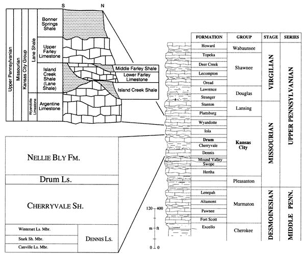
Figure 1--Stratigraphic section showing general relationships and lithologies of the units discussed in this study. Section shows revised stratigraphic nomenclature for the Farley and associated units based on the work of Arvidson (1990) and Watney and Heckel (1994).
This summary of the Farley and associated strata is taken from McKirahan et al. (2000; in press). Those studies analyzed the 3-dimensional variability of an interval of Pennsylvanian (Missourian) strata over a 600 km2 area of northeastern Kansas. Figure 2 illustrates features discussed in the following text.
Figure 2--Cross sections of Farley and associated strata in the northeast Kansas study area (see map). Map shows locations of cross sections. Modified from McKirahan et al. (2000). A larger version of this figure is available.
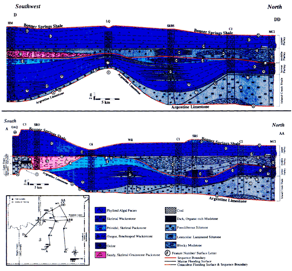
The succession begins with the Argentine Limestone that initially formed on a surface of relatively low relief and built phylloid algal mound facies (reservoir analogs), accumulating thicknesses that range from 2-12 m, which created variable paleotopographic relief that had an effect on subsequent deposition. Little difference in facies from paleohighs to paleolows suggests that mounds formed after a significant relative rise in sea level, with accommodation remaining unfilled over paleohighs and paleolows.
In association with a subsequent relative sea-level fall, marine and nonmarine siliciclastics of the Lane-Island Creek shales were focused into paleotopographic lows, partially filling paleotopography and modifying it with multiple siliciclastic depocenters. These siliciclastics have characteristics of both valley fills and deltaic lobes that created up to 4 m of local relief. This modified relief had a marked effect on later deposition. During a subsequent sea-level rise, siliciclastic influx decreased and carbonate deposition of the lower Farley interval began. Grainy carbonate reservoir facies (oolite and peloidal skeletal packstone) accumulated and built relief on local topographic highs of the Lane-Island Creek deltaic lobes, which were locations of higher energy shallow water during the relative rise or later fall in sea level.
In contrast, phylloid algal facies of the lower Farley interval accumulated in adjacent paleotopographic low areas. Facies variations within the phylloid algal facies reflect a more distal source of siliciclastics with a source direction shifted from the previous one. The shift in source location is likely the result of flooding or filling of pre-existing paleotopographic low areas. In some locations, phylloid algal facies in the lows contain abundant shale, leading to degradation of reservoir quality. Elsewhere, in areas more distant from siliciclastic influx, lower Farley phylloid algal facies, with better reservoir potential, formed in topographic lows and developed thicknesses up to 8 m. Although the exact controls for why one phylloid algal interval fills or builds relief are not well understood, accumulation in topographic lows is likely influenced by sea-level position interacting with the topography. If sea level is positioned just over topographic highs, thereby creating high energy conditions in those areas, the focus of accumulation of phylloid algal facies may shift to flanks or lows adjacent to highs as a function of erosional transport or the quieter water conditions that exist in the lows.
Some uppermost lower Farley strata are characterized by the accumulation of oolitic and skeletal facies in paleolow areas, which may be useful as analogs to carbonate grainstone production in paleolows. Dropping or low sea level at the end of lower Farley deposition either exposed adjacent topographic highs, only allowing for deposition in adjacent low areas, or caused the grainy carbonates to be swept off of the paleohighs and into the paleolows.
After the relative fall in sea level at the end of lower Farley deposition, marine carbonates and siliciclastics of the middle Farley interval were concentrated in paleotopographic low areas and significantly subdued previous paleotopography. Coarse, sandy, skeletal carbonates, potential reservoir analogs, filled subtle paleotopographic low areas because sea level was at just the right position to focus marine currents. Elsewhere, non-reservoir, fine-grained siliciclastics formed preferentially in paleotopographic low areas and filled up to 8 m of topographic relief in association with the relative fall in sea level.
A relative rise in sea level is indicated by a marine flooding unit (fossiliferous siltstone) which is overlain by the fully marine upper Farley lithologies. Lateral consistency in thickness and nature of phylloid algal facies developed in the upper Farley, perhaps building local mound relief upon a relatively flat surface, indicates subdued paleotopography, which had been filled with the deposits of the Lane-Island Creek shales as well as the lower and middle Farley limestones.
Carbonate deposition of the Farley Limestone was terminated by a major relative sea-level fall, which resulted in the accumulation of the Bonner Springs Shale and widespread exposure, erosion, paleosol development, and redevelopment of variable paleotopography in the study area.
This summary of the Drum and associated strata is taken from Feldman et al. (1993), Franseen et al. (1995), and Gomez-Perez et al. (2000). Figure 3 illustrates features discussed in the following text. The Drum Limestone and associated strata crop out in SE Kansas, near the locality of Independence in Montgomery County. The Drum Limestone forms an up to 40 km long and 30 km wide belt characterized by a high degree of variability in facies and thickness. It includes an oolitic body that changes laterally to the northeast (shelfward) to algal and bryozoan mounds. The thickness of the Drum Limestone varies from less than a meter to 24 m. It is wedge-shaped and pinches out in both shelfward and basinward directions. The Drum Limestone was deposited in two main sea level stages, and its thickness and facies changes are interpreted to result from variable paleotopography and changes in relative sea level.
Figure 3--Cross section of the Drum and associated strata in the southeastern Kansas study area (see map). Note that the lower cross section is the same as the upper cross section by at a reduced vertical scale. Map shows location of cross section and distribution of Drum facies. Modified from Gomez-Perez et al. (2000). A larger version of this figure is available.
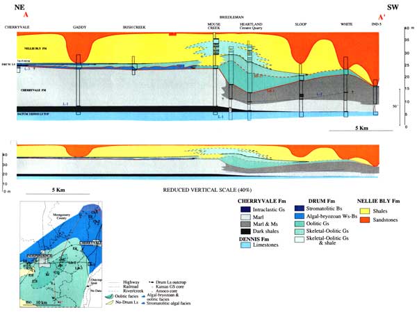
The Cherryvale Shale was part of a marine deltaic system that generally prograded to the south and southwest, apparently filling in some of the low areas left from Winterset deposition. Deposition of the Cherryvale Shale extended the depositional shelf edge to central Montgomery County. The Cherryvale is distributed in one major lobe in the study area. The lobe of Cherryvale Shale thins abruptly to the south from 30 m to 6.5 m over a distance of about 1.6 km in the subsurface southwest of Independence. The southern and western edge of the Cherryvale lobe is interpreted as the depositional slope that was left after cessation of delta progradation. The dominant Cherryvale marl and mudstone facies show upward evolution to interbedded marls and marly limestones, an oolitic-intraclastic bed, and cut and fill, ripple lamination and cross bedding, all pointing to an upward shoaling. The relatively flat top of the Cherryvale lobe suggests that sediment accumulated up to local base level. The upper Cherryvale contact is locally an erosive surface, which eroded up to 10 m of the underlying strata, and represents a relative fall in sea level.
The Drum Limestone rests unconformably on the Cherryvale Shale. An intraclastic lag deposited during transgression is recognizable throughout much of the study area and forms the base of the Drum Limestone. As traced to the northeast, this facies grades to open marine algal mudstones/wackestones, and restricted marine tidal flat laminated facies. All of these facies are interpreted to have formed in low to moderate energy, shallow marine waters. These facies grade upward to stromatolites and algal boundstone facies on inner platform settings. Some of the algal boundstones form meter-scale mounds and buildups. They consist of organically bounded rocks composed of fenestral and/or ramose bryozoans and algae (frame-building organisms), and bivalves, gastropods, brachiopods, crinoids and echinoderms (main accompanying organisms). The boundstone facies grade laterally to oolitic packstones and grainstones in outer platform and platform-margin positions. However, the thickest oolitic accumulations occur in deeper-water depressions just off of the platform edge, reflecting the influence of inherited topography. These oolitic grainstones (reservoir facies) are interpreted as being produced in outer platform and platform-margin positions in marine water less than 2 m deep. Their bypass and accumulation in deeper-water topographically low areas is interpreted to be the result of prevailing ebb currents and decreasing accommodation space in updip positions due to a relative fall in sea level. This stage of deposition ended with subaerial exposure of the inner to outer platform areas. Topographically lower areas off the platform edge are characterized by transported material and hardground development during this relative sea-level drop.
During a subsequent relative sea-level rise, upper Drum oolitic facies were deposited, initially with bimodal cross beds. Later upper Drum oolitic strata are interbedded with shales indicating a deepening-upwards succession. The main controls on the evolution and change in depositional style between the lower and the upper part of the Drum limestone is the inherited topography, along with relative sea level history. Initial paleotopography on the underlying Cherryvale Shale was reduced by lower Drum packstone/grain stone deposits that filled in lows. This subdued paleotopography, and a relative sea-level rise, resulted in a more widespread oolitic system (with more uniform thickness) over the area for initial Drum deposits, which formed in more open marine conditions, relative to lower Drum platform deposits. These skeletal-oolite facies grade laterally (southwestward) to peloidal facies formed in low-energy, open-marine, deep-water environments. Continued relative sea-level rise and increasing siliciclastic input from the southwest resulted in gradual retrogradation of oolitic deposition towards the northeast. Farther to the northwest, skeletal-oolite facies grade to algal-bryozoan packstones to rudstones that were deposited over and infilled topography formed by algal bioherms of the lower Drum unit. The deepening upward sequence over the platform is capped by deposition of a muddy algal-bryozoan facies. Carbonate deposition was terminated throughout the entire area by deposition of Nellie Bly shales. Deposition of the Drum deposits and subsequent Nellie Bly shales greatly subdued the variable topography that had been developed on the Cherryvale Shale.
A relative drop in sea level within the Nellie Bly caused erosion and channeling of previous deposits, which resulted in re-development of variable paleotopography in the study area. Associated incised valleys and other erosional features were filled with sandstones of the Nellie Bly.
The Farley and Drum successions are analogous in scale and facies to many Pennsylvanian reservoirs of North America, where relatively low-relief paleotopography was filled eventually by later deposition, and then re-initiated by constructional or erosional processes. These build-and-fill reservoir systems are complexly heterogeneous, with flow units that may not be laterally continuous, resulting in significant reservoir compartmentalization and production anomalies on interwell and reservoir scales. The Farley and Drum examples show how heterogeneity is controlled by the interaction between sea level, depositional processes and subtle paleotopographic relief.
Among the many controls on building relief in Pennsylvanian reservoirs, such as deformation, erosion and sediment deposition, the latter appears to be of great importance. The Farley and Drum studies illustrate that such relief was built from deposition of phylloid algal and algal-bryozoan mounds, and carbonate grainstone shoals, and was modified by deposition of delta-like wedges.
It is well known that phylloid algal mounds can build relief, even though they may be rooted on relatively low-relief surfaces. For example, in the Paradox basin, Weber et al (1995) illustrated that in Aneth field, phylloid algal facies form individual mounds that stack and coalesce into buildups with good primary porosity. In the Desert Creek and Ismay intervals, Grammer et al. (1996) showed that individual 45-60 m phylloid algal mounds were 8-14 m high with spacing from 33-60 m and tended to coalesce into reservoir units spaced 350-500 m apart. The best porosity and permeability usually is correlated with the cores of individual mound units, thereby limiting the lateral extent of flow units.
In the Farley study, similar phylloid algal mound facies (reservoir analogs) built comparable relief after initially forming on surfaces of relatively low relief. At the base of the studied succession, the Argentine Limestone developed variable relief, accumulating thicknesses that range from 2-12 m. Similarly, phylloid algal facies developed in the upper Farley (e.g. Feature 21 of Figure 2), perhaps building local mound relief upon a relatively flat surface. These two units show little difference in facies from paleohighs to paleolows, and little evidence of deposition near sea level. This suggests that the mounds formed after significant relative rises in sea level, with accommodation remaining unfilled over paleohighs and paleolows. Some of this unfilled accommodation was preserved as paleo-relief on mounds, which had a control on location of subsequent deposits, some of which are analogs for reservoir facies. The Drum study also demonstrates the development of mounds that formed after a significant rise in sea level. In that study, algal-bryozoan mounds developed in the lower Drum on inner shelf positions after a rise in sea level over the underlying Cherryvale Shale. Similar to the Farley, unfilled accommodation was preserved as paleo-relief on mounds, which had a control on location of subsequent deposits, some of which are analogs for reservoir facies.
The Farley study illustrates how the initial relief, created by Argentine mound deposition, was modified by local deposition of siliciclastics, which built local areas of depositional relief within paleolows. The Lane-Island Creek Shale siliciclastics were focused into low areas but did not fill them, creating up to 4 m-high lobe-like features. Similarly in the Drum study, the Cherryvale Shale was part of a marine deltaic system that generally prograded to the south and southwest, apparently filling in some of the low areas left from Winterset deposition. However the low areas were not completely filled and cessation of Cherryvale progradation left a lobe with over 20 meters of relief (Figure 3). Deposition in both cases was associated with a relative fall in sea level, and such deposition should be expected in similar nearshore paleolows after relative falls in sea level.
In both the Farley and Drum studies, this modified relief had a marked effect on later deposition of carbonate grainstone reservoir-analog facies after a relative rise in sea level. In the Farley example, this is illustrated by oolite and peloidal skeletal packstones (Feature 6 on Figure 2), ranging from approximately 1-4 m in thickness, that accumulated and built relief in the north and east on local topographic highs formed by deposition of delta-like Island Creek siliciclastics. These grainy carbonate reservoir analogs formed during relative rises or relative falls in sea level, and are located on local paleohighs because those areas were locations of higher energy shallow water. In the Drum example, lower drum oolitic grainstones built relief of approximately 2 m at the major break in slope on the Cherryvale Shale (Mouse Creek location on Figure 3) and on a local Cherryvale high farther to the southwest (White location on Figure 3) after a rise in sea level. However, building of relief of these deposits in the lower Drum was limited by a subsequent fall in sea level, and most of the shallow-water oolite deposits were transported to lows (discussed below). During a subsequent rise in sea level, upper Drum skeletal-oolite facies, approximately 1-4 m in thickness, were able to accumulate on highs and build relief (Figure 3).
Carbonate grainstone shoals comprise a common relief-building facies; many examples exist of reservoirs formed from similar or identical facies described for the Drum and Farley studies. Relief-building carbonate grainstone facies are well known from Aneth field (Weber et al. 1995), but another example comes from the Hall-Gurney Field located on the Central Kansas Uplift (CKU) in Kansas (Watney et al., 2000). The principle reservoirs from this interval are oolitic grainstones in the C/D, E/F, and G Zones (Plattsburg, Farley/Argentine, and Iola Limestones) of the Upper Pennsylvanian Lansing and Kansas City groups that form stacked pays over the field. Each field ranges from 315 m in thickness. The oolite shoal deposits resemble thickened pods of porous carbonate, in the subsurface, and their distribution was strongly influenced by depositional topography. Similar to results of the Farley and Drum studies, local topographic highs and sloping surfaces were preferred sites for the development of high-energy conditions where shallow water allowed waves and currents to form oolitic grainstone.
The Farley and Drum studies demonstrate that once relief has been built by sedimentation, it is commonly filled, resulting in greatly reduced relief for subsequent deposition. The filling facies are analogs of both reservoir and non-reservoir facies, and greatly complicate the reservoirs.
Coarse siliciclastic fills in incised valleys are well-known reservoir rocks (Dalrymple, 1994). The upper Nellie Bly sandstones of the Drum study are an analog (Figure 3). These coarse siliciclastics filled incised valleys and other erosional features that developed due to a relative fall in sea level. In the Farley study, coarse, sandy, skeletal carbonates (Feature 17 on Figure 2; up to 5-m thick) resemble valley fill deposits that filled subtle paleotopographic low areas. Facies were preserved as coarse-grained, potential reservoir facies because, after sea level reached just the right position, the geometry of paleotopographic lows created areas for focused marine currents. We hypothesize that if sea level had been slightly lower or higher, the currents would not have been focused, and coarse, reservoir-prone deposits would have been lacking.
In contrast, there are subsurface examples in which non-reservoir siliciclastic facies are focused into paleotopographic lows. Dubois (1985) described an example of a Pennsylvanian mixed carbonate-siliciclastic reservoir from Hitchcock, Nebraska. During deposition of the Lansing-Kansas City E zone (partially equivalent to the Farley Limestone), paleotopography was relatively flat to mildly undulating, with maximum relief of 30-60 ft (9-18 m), with local positive features of 15-30 ft (4.5-9 m). The best reservoirs are carbonates formed on the paleohighs and non-reservoir fine siliciclastics are concentrated in paleotopographic low areas adjacent to them.
Similar relationships are seen in the fine-grained siliciclastics of the middle Farley interval (Features 15 and 16 on Figure 2) and fine, shale-rich carbonates (Feature 12 on Figure 2) of the lower Farley interval. For the lower Farley interval, phylloid algal facies formed preferentially in paleotopographic low areas, but contained abundant shale, which would make the unit a poor reservoir (Feature 12 on Figure 2). These siliciclastics were focused into this low area after a relative rise in sea level and after earlier filling of paleotopography had caused a shift in the position of siliciclastic deposition. The observed relationship suggests that in the lower Farley interval, areas more distant from the siliciclastic influx would show cleaner phylloid algal facies, more prone to forming a good reservoir. For Features 15 and 16 on Figure 2, fine-grained delta-like siliciclastics filled up to 8 m of topographic relief in association with a relative fall in sea level.
In Aneth Field, Weber et al. (1995) discussed ooid and peloid grainstone reservoir facies in the upper Desert Creek interval, interpreted to be related to highstands, and in the lower Ismay, they described carbonate grainstone debris aprons as reservoirs formed during early lowstands. Importantly, some of the thick carbonate grainstone reservoirs appear to thicken into paleotopographic low areas. Other carbonate reservoirs show evidence of preferred carbonate porosity in paleolows, although origin is commonly unknown. In the Upper Pennsylvanian Palo Pinto Limestone of Runnels County Texas, Doss and Spiva (1968) described that west of the Norton West field, there was a porosity channel meandering generally southwestward into Kocke County, and that outside of this channel, the Palo Pinto is present but has absolutely no effective porosity or permeability. In the Winters North field there is a low relief structure with updip and flank pinchouts of porosity.
Grainy carbonates in the Farley and Drum studies, such as the grainy oolitic, peloidal and skeletal facies in the Farley (Features 13 and 14 on Figure 2) and the thickest accumulations of oolitic grainstone in the lower Drum (Figure 3), may prove useful as analogs to carbonate grainstone production in paleolow areas. In both examples, deposition of the grainy facies was associated with dropping or low sea level that either exposed adjacent topographic prominences, only allowing for deposition in low areas, or caused grainy carbonates to be swept off of the paleohighs and into the paleolows.
As described earlier, phylloid algal facies are common reservoir facies of the Pennsylvanian and early Permian. Most of these reservoirs are considered to form preferably on paleohighs and build relief. However, there is strong evidence that some phylloid algal reservoir facies also thicken into paleolow areas, complicating the traditional models for phylloid algal production. In outcrops of the Permian Laborcita Formation in New Mexico, it is clear that phylloid algal mounds can begin forming on relatively low relief surfaces, and then build relief (McKirahan et al., in press). Afterward, further deposition of phylloid algal-rich carbonate fills the relief, subduing the topography created by mound construction. In the subsurface, there is ample support for production from phylloid algal facies that essentially fill paleotopographic low areas. Perhaps the best example is in the lower Desert Creek interval of the Paradox basin, where phylloid algal reservoirs produce in a position more basinward than Aneth field (Matheny and Longman, 1996). These reservoirs appear to thicken into paleolows, produced by salt dissolution of underlying units. Another example comes from Watney (1980) from the Cahoj-Wilhelm fields in Rawlins County, Kansas. In the highest topographic area (the Cahoj Field high), the Lansing-Kansas City E-zone thickened through accumulation of shoal-water grainstone and packstone, but to the south, off of the high, the E-Zone shows thickening of phylloid algal carbonate, interpreted to have formed during the transgression. Although E-Zone phylloid-algal facies on the flanks were not productive there, Watney (1980) indicated that similar phylloid algal facies in the middle and lower D Zone are locally productive in Happy and Seberger fields located in a similar off-structure area in Northwest Rawlins County, Kansas.
Much of the phylloid algal facies in the Farley study was deposited as fillings of paleotopographic lows. An example of phylloid algal facies in lows is Feature 8 on Figure 2, which developed thicknesses up to 8 m. Although the exact controls for filling, as opposed to building, are not well understood for this facies, its accumulation in topographic lows is likely influenced by sea-level position interacting with the topography. If sea level is positioned just over topographic highs, thereby creating high energy conditions in those areas, the focus of accumulation of phylloid algal facies may shift to flanks, or lows adjacent to highs, as a function of erosional transport or the quieter water conditions that exist in the lows. The highs may accumulate higher energy facies such as oolite. In contrast, where sea level is higher in relation to paleotopography, the deeper conditions lead to building topography with phylloid algal facies.
The complex interplay of sea level, paleotopography, water energy, and location of siliciclastic depocenters form "build-and-fill" sequences that control heterogeneity of many Pennsylvanian reservoirs. Topographic highs may be favored areas of building of shallow-water carbonate reservoir facies. Where significant water depths have been achieved, phylloid algal reservoir facies may build relief. Where shallow water intersects paleotopographic highs, carbonate grainstone reservoir facies may build relief. Localized deposition, of non-reservoir delta-like siliciclastics may create relief in paleo-low areas.
In contrast, many reservoir and non-reservoir facies fill relief. Where shallow-water conditions intersect complex paleotopography, currents may be focused, depositing grainy carbonate and siliciclastic reservoir facies in paleo-low areas. In addition, if energies are too high along the topographic highs, more quiet-water facies, such as phylloid algal boundstone and packstone and skeletal wackestone-packstone may accumulate (fill) in the topographic lows where current energies are weaker. Finally, proximity to fine-grained siliciclastic depocenters may inhibit the development of carbonate reservoir facies that are dependent on clear-water conditions for production.
Arvidson, R.S., 1990, Stratigraphy, carbonate petrology, diagenesis, and trace element cement geochemistry of the Wyandotte limestone (Upper Pennsylvanian), Miami County, Kansas: Unpub. Master's Thesis, University of Iowa, 213 p.
Brown, H.A., 1963, Examination of Pennsylvanian carbonate banks in southwestern Kansas: Kansas Geological Survey, Open-file Report 63-5, 9 p.
Dalrymple, Robert W., Boyd, Ron, and Zaitlin, B. A., 1994, Incised-Valley Systems: Origin and Sedimentary Sequences: SEPM, Special Publication 51, 391 p.
Doss, A.K., Jr., and Spiva, F.J., Jr., 1968, Palo Pinto Limestone Production, Western Runnels County, Texas: American Association of Petroleum Geologists, Bulletin, v. 52, p. 82-91.
Dubois, M.K., 1985, Application of Cores in Development of an Exploration Strategy for the Lansing-Kansas City "E" Zone, Hitchcock County, Nebraska; in, Watney, W.L., Walton, A.W., and Doveton, J.H., compilers, Core Studies in Kansas Sedimentology and Diagenesis of Economically Important Rock Strata in Kansas: Kansas Geological Survey, Subsurface Series 6, p. 120-132.
Feldman, H.R., Franseen, E.K., Miller, R.A., and Anderson, N.L., 1993, A Model of Missourian Oolitic Petroleum Reservoirs Based on the Drum Limestone in Southeastern Kansas: Kansas Geological Survey, Open-file Report 93-28, 67 p.
Franseen, E.K., Feldman, H.R., Anderson, N.L., and Miller, R.D., 1995, Depositional and Stratigraphic Analysis of Kansas City Group Strata Utilizing High-Resolution Seismic Imaging, Montgomery County, Kansas; in, Anderson, N.L., Hedke, D. et al., eds., Geophysical Atlas of Kansas: Kansas Geological Survey, Bulletin 237, p. 43-46.
Gianniny, G.L., and Simo, J.A.T., 1996, Implications of unfilled accommodation space for sequence stratigraphy on mixed carbonate-siliciclastic platforms: An example from the lower Desmoinesian (Middle Pennsylvanian), southwestern Paradox Basin, Utah; in, M.W. Longman and M.D. Sonnenfeld, eds., Paleozoic Systems of the Rocky Mountain Region, Rocky Mountain Section-SEPM, p. 213-234.
Goldhammer, R.K., Oswald, E.J., and Dunn, P.A., 1991, Hierarchy of stratigraphic forcing: Examples from Middle Pennsylvanian shelf carbonates of the Paradox basin, in, E.K. Franseen, W.L. Watney, C.G. St. C. Kendall, and W. Ross, eds., Sedimentary modeling: Kansas Geological Survey, Bulletin 233, p. 361-413.
Grammer, G.M., Eberli, G.P., Van Buchem, F.S.P., Stevenson, G.M., and Homewood, P., 1996, Application of high-resolution stratigraphy to evaluate lateral variability in outcrop and subsurface-Desert Creek and Ismay intervals, Paradox basin; in, M.W. Longman and M.D. Sonnenfeld, eds., Paleozoic Systems of the Rocky Mountain Region: Rocky Mountain Section SEPM (Society for Sedimentary Geology), p. 235-266.
Gomez-Perez, I., Feldman, H.R., Franseen, E.K, and, Simo, A.J., 1997, Evolution and Diagenesis of an Oolitic Limestone (Drum Formation), Missourian, Kansas, USA: Kansas Geological Survey, Open-file Report 97-74, 12 p.
Heckel, P.H., 1972, Recognition of ancient shallow marine environments; in, Rigby, J.K., and Hamblin, W.K., eds., Recognition of Ancient Sedimentary Environments: Society of Economic Paleontologists and Mineralogists, Special Publication, No. 16, p. 226-286.
Matheny, J. Paul, and Longman, M. W., 1996, Lower Desert Creek Reservoirs in the Paradox Basin: examples of phylloid algae filling depositional lows related to salt dissolution in Longman, M.W., and Sonnenfeld, M.D., eds., Paleozoic Systems of the Rocky Mountain Regions. Rocky Mountain Section, Society of Economic Paleontologists and Mineralogists, p. 267-282.
McKirahan, J., Goldstein, R.H., and Franseen, E.K., 2000, Sequence Stratigraphy of the Lane-Island Creek Shales and the Farley Limestone in Northeastern Kansas and Geologic Factors Affecting the Quality of Limestone Aggregates: K-TRAN Report No. KU-97-1, 236 p.
Mckirahan, J., Goldstein R.H., and Franseen, E.K., in press, Build-and-Fill Sequences: How Subtle Paleotopography Affects 3-D Heterogeneity of Potential Reservoir Facies; in, Ahr, W.M., Harris, P.M., Morgan, W.A., Somerville, I.D., and Stanton, R.J. Jr., eds., Permo-Carboniferous Carbonate Platforms and Reefs: SEPM/AAPG, Special Memoir Publication.
Newell, K.D., Watney, W.L., Cheng, S.W.L., and Brownrigg, R.L., 1987, Stratigraphic and Spatial Distribution of Oil and Gas Production in Kansas: Kansas Geological Survey, Subsurface Geology Series 9, 86 p.
Walters, R.F., Gutru, R.J., and James, A., III, 1979, Channel sandstone oil reservoirs of Pennsylvanian age in northwestern Ness County, Kansas; in, N.J. Hyne, ed., Pennsylvanian Sandstones of the Midcontinent: Tulsa Geological Society, Special Publication No. 1, p. 313-326.
Wanless, H.R., 1931, Pennsylvanian section in western Illinois: Geological Society of America, Bulletin, v. 42, p. 801-812.
Wanless, H.R., 1972, Eustatic shifts in sea level during the deposition of Late Paleozoic sediments in the central United States; in, J.G. Elam and S. Chuber, eds., Cyclic Sedimentation in the Permian Basin, 2nd ed.: West Texas Geological Society, Publication, 72-60, p. 41-54.
Watney, W.L., 1980, Cyclic sedimentation of the Lansing and Kansas City groups (Missourian) in northwestern Kansas and southwestern Nebraska--a guide for petroleum exploration: Kansas Geological Survey, Bulletin 220, 72 p. [available online]
Watney, W.L., 1985, Origin of Four Upper Pennsylvanian (Missourian) Cyclothems in the Subsurface of Western Kansas--Application to Search for Accumulation of Petroleum: Unpublished Ph. D. Dissertation, University of Kansas, 506 p.
Watney, W.L., French, J. A., Franseen, E.K., 1989, Sequence stratigraphic interpretations and modeling of cyclothems in the Upper Pennsylvanian (Missourian), Lansing and Kansas City groups in eastern Kansas: Guidebook of the Kansas Geological Society, 41st Annual Fieldtrip, 211 p.
Watney, W.L., and Heckel, P.H., 1994, Revision of the stratigraphic nomenclature and classification of the Marmaton, Pleasanton, and Kansas City groups in Kansas: Kansas Geological Survey, Open-file Report 94-34, p. 1-18.
Watney, W.L., Bujis, G., Byrnes, A.P., Guy, W.J., and Dubois, M.K., 2000, Task 4. Reservoir Characterization of Hall Gurney Field: Kansas Technology Enterprise Corporation Report, p. 4.1-4.71.
Weber, J.L., Wright, F.M., Sarg, J.F., Shaw, Ed, Harman, L.P., Vanderhill, J.B., and Best, D.A., 1995, Reservoir delineation and performance--Application of sequence stratigraphy and integration of petrophysics and engineering data, Aneth field, southeast Utah, U.S.A.; in, E.L. Stoudt and P.M. Harris, eds., Hydrocarbon Reservoir Characterization, Geologic Framework and Flow Unit modeling. SEPM (Society for Sedimentary Geology) Short Course 34, p. 1-29.
Wilson, J. L., 1967, Cyclic and reciprocal sedimentation in Virgilian strata of southern New Mexico: Geological Society of America, Bulletin, v. 78, p. 805-818.
Kansas Geological Survey, Geology
Placed online Sept. 4, 2007; OFR from 2002.
Comments to webadmin@kgs.ku.edu
The URL for this page is http://www.kgs.ku.edu/Publications/OFR/2002/OFR02_54/index.html