Kansas Geological Survey, Open-file Report 2001-40
by Robert Sawin and Rex Buchanan
KGS Open-file Report 2001-40
(Revised July 2008)
Kansas Geological Survey Open-file Report 2001-40 was revised in July 2008.
Changes:
The Tallgrass Prairie National Preserve, established in 1996, consists of 10,894 acres in Chase County, Kansas, all within the Flint Hills physiographic region (U.S. Dept. of the Interior, 2000, p. 1). Springs are an important feature of the preserve (a property once known as Spring Hill Ranch, and more recently, the Z Bar Ranch). Springs were the original source of water on the ranch; they continue to provide water to livestock and are important to the diverse flora and fauna on the property. Yet relatively little was known about their extent, flow rates, exact location, and water quality.
Knowledge about the preserve's springs will provide the National Park Service (NPS) and the National Park Trust (NPT) with basic, benchmark information about the nature of the preserve's water resources. One desired outcome in the preserve's General Management Plan is: "The preserve's seeps, springs, and streams are in good ecological condition and support a healthy and diverse aquatic community" (U.S. Dept. of the Interior, 2000, p. 11). However, the plan notes that "the preserve lacks long-term data sets on water quality, hydrology, and geomorphology" (U.S. Dept. of the Interior, 2000, p. 72). An accurate inventory of springs is necessary to measure the preserve's ability to achieve its long-term goals. The information should also be useful as the preserve's land-use patterns (such as burning regimes, grazing, and human visitation) change in the future.
In addition, development of the preserve as a new national resource offers a unique opportunity to gather baseline information on the various components of the natural system. Springs provide a rare opportunity to monitor groundwater conditions in a relatively pristine grassland environment, without using invasive hydrogeologic techniques. As a result, knowledge gained at the preserve will be useful throughout the Flint Hills region.
Based on a cooperative agreement between the Kansas Geological Survey (KGS) and the National Park Service (Cooperative Agreement Number H6067A00009), the KGS undertook a comprehensive inventory of springs on the preserve. Springs are generally defined as locations where "groundwater flows naturally from the earth into a body of surface water or onto the land surface, at a rate sufficient to form a current" (Buchanan, Sawin, and Lebsack, 1998). This differentiates springs from seeps, where water is discharged onto the surface at rates so low that no current or channel is created.
Preliminary visits to the preserve in December 1998 and March 1999 found seven locations that met the definition of a spring. Both the NPS/NPT and the KGS were interested in examining seasonal changes in the basic water chemistry in these springs. As a result, water from springs at the preserve was sampled and analyzed for basic constituents by the KGS every three months, for one year. In addition, the Kansas Department of Health and Environment did a full analysis (organic and inorganic components) at three of these springs. The results of both of these activities, made available to the NPS/NPT, showed that the quality of water in preserve springs was generally extremely high (Sawin and Buchanan, 2000). This work provided the NPS/NPT with water-quality data, over time, on an important component of the prairie ecosystem and provides a better understanding of the nature of springs in a relatively undisturbed Flint Hills environment.
KGS authors also published papers and abstracts on the springs of the Flint Hills region of Kansas (Sawin, Buchanan, and Lebsack, 1999a; Sawin, Buchanan, and Lebsack, 1999b; Buchanan and Sawin, 2000). Preserve springs were included in the discussions of Flint Hills springs in Sawin, Buchanan, and Lebsack (1999b) and Buchanan and Sawin (2000).
For the inventory, the preserve was divided into 17 drainage areas (see Plate 1, attached). The field procedure involved systematically walking each drainage and locating springs on a 1:24,000-scale U.S. Geological Survey topographic map (Strong City, Kansas quadrangle) and, electronically, with hand-held 12-channel Garmin Global Positioning System (GPS) units with an accuracy of 15 meters RMS (root mean square) or better. Springs were described and photographed, and flow rates estimated. The geologic unit from which each spring flowed was identified.
The initial survey was conducted April 9-18, 2001, when most prairie vegetation was dormant and immediately after most of the preserve pastures had been burned. Vegetation associated with the springs was green and contrasted sharply with the surrounding dormant plants and burned vegetation. General moisture conditions and rainfall at the preserve were estimated to be "normal" for that time of the year by NPS and KGS staff (see fig. 1). This initial inventory was completed prior to the annual springtime introduction of cattle onto the preserve's pastures.
Figure 1. Precipitation at Cottonwood Falls, Kansas, from August 2000 through July 2001.
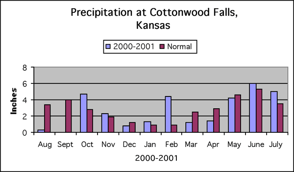
A geographically representative number of these springs was revisited on August 7-8, 2001. This follow-up survey was designed to observe springs during the driest time of the year, to generate information that would indicate the permanent or temporary nature of preserve springs. Springs revisited were selected to provide a geographic sampling of each drainage; to provide additional information on particularly large or significant springs; and to provide a sample of dry-weather flow rates at randomly selected locations. Again, NPS and KGS staff agreed general moisture and rainfall conditions were about normal. Nearly all cattle had been removed from the ranch by the time of this revisit.
During the April survey, 237 springs were inventoried. As defined above, these were locations where moving water was observed emerging from the ground, regardless of the flow rate. The flow rate for 135 of these springs (57%) was estimated at 1 gallon per minute (gpm) or less. Almost all of these springs would be considered intermittent, or "wet weather," springs. Thirty-nine springs (16%) had flow rates estimated at 5 gpm or more.
In August, 61 springs were revisited (26% of the springs inventoried in April). As expected, flow rates were significantly less, and many of the low-flowing springs were dry or reduced to seeps. Of the 61 springs revisited, 22 (or about 36%) were dry in August. Twelve (or about 20%) were now seeps, and 14 (or about 23%) flowed less than 1 gpm. In total, nearly 80% of the springs observed in April were dry or flowing less than 1 gpm in August, including several springs that had significant (10-15 gpm) flows in April. Of the springs that were flowing in August, many had been reduced to about 20% of their April flow.
Nearly all the springs on the preserve that were inventoried in this study are classified as contact springs. Contact springs flow to the land surface from a permeable material (limestone) that lies directly on top of a less permeable layer (shale) that retards or prevents the downward movement of groundwater, causing it to be deflected laterally by gravity in the downdip direction. The water continues to move through fractures and pore space in the limestones along the contact between the permeable and less permeable layer until it is intersected by a stream valley or hillside, where it then issues onto the land surface.
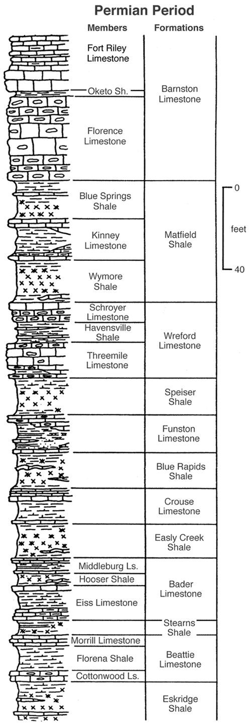
Data from the April and August visits is shown by drainage (Table 1) and by flow rate, from highest to lowest (Table 2). Also included in the tables are the rock unit that produced water at each spring. Figure 2 is an idealized geologic section of the rock units that occur on the preserve. Spring locations are spotted on the Strong City, Kansas, 1:24,000-scale U.S.G.S. base (Plate 1). The GPS receivers datum was set to WGS 84. An ArcView file of the tables and map will be made available to NPS/NPT.
Figure 2. Idealized section of the rock units at Tallgrass Prairie National Preserve.
Historically, springs have been an important component at the Tallgrass Prairie National Preserve. Springs provide a window to the water resource at the preserve, and can be used to monitor water quality and quantity conditions through time. Water at the preserve is a critical resource upon which all other components (flora and fauna) rely. This comprehensive inventory of springs provides baseline information that will be useful in planning development at the preserve, evaluating past activities, and monitoring the impact of future activities, such as livestock grazing, backcountry use, and burning. This information will also help guide future investigations of flora, fauna, and hydrologic systems.
This inventory showed that a substantial number of springs occur on the preserve, particularly in the wet weather of spring. Twenty-five of these springs produced large volumes of water, more than 10 gpm. As expected, dry conditions during summer had a substantial impact on many of these springs, particularly the lesser-producing springs. However, a significant number of springs continued to produce substantial amounts of water even in the dry weather of summer; because of their reliability, they are especially important water sources for livestock and flora and fauna on the preserve. Because springs are so important to the preserve, it is anticipated that the information in this report will be useful to resource managers, researchers, and other areas in the Flint Hills region.
Buchanan, R. C., and Sawin, R. S., 2000, Water Quality and Quantity in Flint Hills Springs: Kansas Academy of Science, Abstracts, v. 19, p. 6.
Buchanan, R., Sawin, R., and Lebsack, W., 1998, Kansas Springs: Kansas Geological Survey, Public Information Circular 11, 4 p.
Sawin, R., and Buchanan, R., 2000, Water Quality of Selected Springs--Tallgrass Prairie National Preserve, Chase County, Kansas: Kansas Geological Survey, Open-file Report 2000-01 (Revised July 2008), 31 p. [available online]
Sawin, R. S., Buchanan, R. C., and Lebsack, W., 1999a, Flint Hills Springs: Transactions of the Kansas Academy of Science, v. 102, no. 1-2, p. 1-31.
Sawin, R. S., Buchanan, R. C., and Lebsack, W., 1999b, Springs in the Kansas Flint Hills--An Historical Comparison of Water Quality and Quantity: Geological Society of America, Abstracts with Program , v. 31, no. 7, p. 330-331.
U.S. Department of the Interior, National Park Service, 2000, Final General Management Plan/Environmental Impact Statement, Tallgrass Prairie National Preserve, Kansas, September 2000, 195 p., plus appendix.
Table 1. Spring Data by Drainage Areas. Spring numbers in ( ) are from Sawin and Buchanan, 2000.
| Spring No. | GPS (north) | GPS (west) | Est. Flow April |
Est. Flow August |
Geol. Unit | Misc |
|---|---|---|---|---|---|---|
| 1-1 | 38.49592 | 96.56844 | 5 | Funston | ||
| 1-2 | 38.49353 | 96.57417 | <1 | Funston | ||
| 1-3 | 38.49375 | 96.57684 | 4 | seep | Funston | |
| 1-4 | 38.49470 | 96.57671 | 2 | <1 | Threemile | |
| 1-5 | 38.49533 | 96.57724 | 2 | <1 | Threemile | |
| 1-6 | 38.49563 | 96.57728 | 2 | <1 | Threemile | |
| 1-7 | 38.48694 | 96.58694 | <1 | Threemile | ||
| 1-8 | 38.48564 | 96.57862 | <1 | Funston | ||
| 1-9 | 38.48939 | 96.57813 | <1 | Crouse | ||
| 1-10 | 38.48944 | 96.57617 | 1 | Funston | ||
| 1-11 | 38.48937 | 96.56897 | 1 | Funston | ||
| 1-12 | 38.48822 | 96.57022 | 1 | Funston | ||
| 1-13 | 38.48451 | 96.58178 | <1 | Funston | ||
| 1-14 | 38.48421 | 96.58268 | 5 | Funston | ||
| 1-15 | 38.48333 | 96.58329 | 1 | Threemile | ||
| 1-16 | 38.48613 | 96.59304 | 1 | Threemile | ||
| 1-17 | 38.48490 | 96.59174 | 2 | Threemile | ||
| 1-18 | 38.49408 | 96.59376 | 25 | 5 | Threemile | |
| 1-19 | 38.49445 | 96.59368 | 3 | Threemile | ||
| 1-20 | 38.49530 | 96.58692 | 10 | Threemile | ||
| 1-21 (CS-H) | 38.49187 | 96.59001 | 2 | Funston | ||
| 2-1 | 38.48362 | 96.57487 | <1 | Funston | ||
| 2-2 | 38.47724 | 96.56919 | <1 | Crouse | ||
| 2-3 | 38.47246 | 96.56893 | 15 | seep | Easly Ck | |
| 2-4 | 38.47241 | 96.57051 | 10 | dry | Crouse | |
| 2-5 | 38.47282 | 96.57238 | <1 | Funston | ||
| 2-6 | 38.47326 | 96.57340 | <1 | Funston | ||
| 2-7 | 38.47567 | 96.57272 | 1 | Funston | ||
| 2-8 | 38.47546 | 96.57381 | 3 | Funston | ||
| 2-9 | 38.48151 | 96.57676 | 3 | Funston | ||
| 3-1 | 38.47750 | 96.58322 | 3 | Threemile | ||
| 3-2 | 38.46958 | 96.57664 | 2 | dry | Funston | |
| 3-3 | 38.46872 | 96.57728 | 3 | seep | Easly Ck | |
| 3-4 | 38.47060 | 96.58290 | 1 | Funston | ||
| 3-5 | 38.47386 | 96.58902 | 2 | Threemile | ||
| 3-6 | 38.47071 | 96.58864 | 2 | Threemile | ||
| 3-7 | 38.46862 | 96.58372 | <1 | Funston | ||
| 3-8 | 38.46504 | 96.57301 | 1 | Middleburg | ||
| 3-9 | 38.46282 | 96.57688 | 2 | Crouse | ||
| 3-10 | 38.46468 | 96.58656 | <1 | Threemile | ||
| 3-11 | 38.45914 | 96.58181 | 2 | Threemile | ||
| 3-12 | 38.45958 | 96.57911 | 5 | Funston | ||
| 3-13 | 38.45694 | 96.57997 | 5 | Threemile | ||
| 3-14 | 38.46363 | 96.56648 | 3 | Eiss | ||
| 3-15 | 38.46103 | 96.56637 | 1 | seep | Eiss | |
| 3-16 | 38.45945 | 96.56729 | 2 | dry | Crouse | |
| 3-17 | 38.45800 | 96.57670 | <1 | Threemile | ||
| 3-18 | 38.47427 | 96.57930 | 7 | Funston | ||
| 4-1 | 38.46345 | 96.59527 | <1 | dry | Wymore | |
| 5-1 | 38.43699 | 96.59535 | <1 | dry | Threemile | |
| 5-2 | 38.43535 | 96.59683 | 2 | <1 | Threemile | |
| 5-3 | 38.43693 | 96.59718 | 1 | <1 | Threemile | |
| 5-4 | 38.44226 | 96.59269 | <1 | Threemile | ||
| 5-5 | 38.44241 | 96.59262 | <1 | Schroyer | ||
| 5-6 | 38.44366 | 96.59023 | 2 | Threemile | ||
| 5-7 | 38.44498 | 96.59341 | <1 | Threemile | ||
| 5-8 | 38.44840 | 96.59322 | <1 | Threemile | ||
| 5-9 | 38.45159 | 96.59350 | <1 | Threemile | ||
| 5-10 | 38.45827 | 96.59153 | <1 | Kinney | ||
| 5-11 | 38.43103 | 96.59573 | 1 | Threemile | ||
| 5-12 | 38.43080 | 96.59670 | 1 | Threemile | ||
| 5-13 | 38.42730 | 96.59754 | <1 | Threemile | ||
| 6-1 (CS-F) | 38.44256 | 96.56775 | 20 | Eiss | Developed | |
| 6-2 | 38.44101 | 96.57104 | <1 | Crouse | ||
| 6-3 | 38.44141 | 96.57111 | 2 | Crouse | ||
| 6-4 | 38.44111 | 96.57351 | 1 | Funston | ||
| 6-5 | 38.43922 | 96.57171 | 2 | Funston | ||
| 6-6 | 38.45254 | 96.58061 | <1 | dry | Threemile | |
| 6-7 | 38.45119 | 96.58043 | 1 | dry | Funston | |
| 6-8 | 38.45107 | 96.57970 | 10 | 2 | Funston | |
| 6-9 | 38.45015 | 96.58174 | 1 | Threemile | ||
| 6-10 | 38.44969 | 96.58427 | 1 | Schroyer | ||
| 6-11 | 38.45515 | 96.58647 | <1 | Wymore | ||
| 6-12 | 38.45405 | 96.58493 | <1 | Schroyer | ||
| 6-13 | 38.45208 | 96.58165 | 3 | <1 | Threemile | |
| 6-14 | 38.45095 | 96.57811 | 3 | 2 | Funston | |
| 6-15 | 38.44685 | 96.58347 | <1 | Schroyer | ||
| 6-16 | 38.44522 | 96.58210 | 2 | Threemile | ||
| 6-17 | 38.44468 | 96.58209 | 1 | Threemile | ||
| 6-18 | 38.44426 | 96.58007 | 4 | Funston | ||
| 6-19 | 38.44128 | 96.57746 | 1 | Funston | ||
| 6-20 | 38.44101 | 96.57855 | <1 | Threemile | ||
| 6-21 (CS-J) | 38.43938 | 96.58066 | <1 | Schroyer | ||
| 6-22 | 38.44448 | 96.57325 | 2 | Easly Ck | ||
| 6-23 | 38.44393 | 96.57369 | 20 | Easly Ck | ||
| 6-24 | 38.44781 | 96.57548 | 25 | 4 | Crouse | Developed |
| 6-25 | 38.45047 | 96.57318 | 2 | Funston | ||
| 6-26 | 38.45114 | 96.57017 | <1 | Funston | ||
| 6-27 | 38.45099 | 96.56781 | <1 | Funston | ||
| 6-28 | 38.44059 | 96.56565 | <1 | Eiss | ||
| 6-29 | 38.44171 | 96.56071 | <1 | dry | Eiss | |
| 7-1 | 38.45592 | 96.56843 | <1 | dry | Funston | |
| 7-2 | 38.45435 | 96.56332 | 1 | Eiss | ||
| 7-3 | 38.45443 | 96.56753 | 1 | Funston | ||
| 7-4 | 38.43785 | 96.55435 | <1 | Cottonwood | ||
| 8-1 | 38.41239 | 96.58337 | <1 | Easly Ck | ||
| 8-2 | 38.41375 | 96.58138 | 15 | 7 | Crouse | Developed |
| 8-3 | 38.42562 | 96.57697 | <1 | Funston | ||
| 8-4 | 38.42626 | 96.58315 | <1 | Crouse | ||
| 8-5 | 38.42700 | 96.58311 | <1 | Crouse | ||
| 8-6 | 38.42919 | 96.58154 | <1 | Funston | ||
| 8-7 | 38.43316 | 96.57993 | <1 | Threemile | ||
| 8-8 | 38.43396 | 96.58025 | <1 | Threemile | ||
| 8-9 | 38.41880 | 96.58626 | <1 | Crouse | ||
| 8-10 | 38.42197 | 96.58896 | <1 | Funston | ||
| 8-11 | 38.41886 | 96.59137 | <1 | Funston | ||
| 8-12 | 38.42218 | 96.59462 | <1 | Threemile | ||
| 8-13 | 38.41846 | 96.59503 | <1 | Threemile | ||
| 8-14 | 38.41803 | 96.59232 | 1 | Funston | ||
| 8-15 | 38.41276 | 96.58818 | 2 | Easly Ck | ||
| 8-16 | 38.41460 | 96.59145 | 1 | Funston | ||
| 8-17 | 38.41481 | 96.59713 | 1 | Threemile | ||
| 8-18 | 38.41074 | 96.58803 | <1 | Middleburg | ||
| 8-19 | 38.43658 | 96.58641 | <1 | seep | Schroyer | |
| 8-20 | 38.43699 | 96.58782 | <1 | dry | Schroyer | |
| 8-21 (CS-A) | 38.42314 | 96.58554 | 100 | Easly Ck | Developed | |
| 8-22 | 38.43505 | 96.58891 | <1 | Threemile | ||
| 8-23 | 38.43210 | 96.59140 | <1 | Threemile | ||
| 8-24 | 38.43375 | 96.59296 | <1 | Schroyer | ||
| 8-25 | 38.42807 | 96.59324 | <1 | Schroyer | ||
| 8-26 | 38.42691 | 96.59211 | 2 | Threemile | ||
| 8-27 | 38.43018 | 96.58688 | 2 | Funston | ||
| 8-28 | 38.42543 | 96.58569 | 2 | Easly Ck | ||
| 8-29 (CS-C) | 38.41365 | 96.57946 | <1 | <1 | Threemile | |
| 8-30 (CS-B) | 38.41796 | 96.57846 | 10 | Funston | Developed | |
| 8-31 (CS-G) | 38.41478 | 96.58501 | 5 | 5 | Easly Ck | Developed |
| 9-1 | 38.43014 | 96.57487 | <1 | Threemile | ||
| 9-2 | 38.42912 | 96.57263 | 1 | Funston | ||
| 9-3 | 38.42848 | 96.56739 | <1 | Crouse | ||
| 9-4 | 38.42784 | 96.57073 | <1 | Funston | ||
| 9-5 | 38.42810 | 96.57039 | <1 | Funston | ||
| 9-6 | 38.43057 | 96.56124 | <1 | Eiss | ||
| 9-7 | 38.42969 | 96.56059 | 35 | 16 | Eiss | |
| 9-8 | 38.42946 | 96.56311 | 2 | Middleburg | ||
| 9-9 | 38.42909 | 96.56393 | 2 | Middleburg | ||
| 9-10 | 38.43108 | 96.56796 | 2 | Crouse | ||
| 9-11 | 38.43163 | 96.57199 | 1 | Funston | ||
| 9-12 | 38.43319 | 96.57288 | 3 | Funston | ||
| 9-13 | 38.43421 | 96.57259 | 5 | Funston | ||
| 9-14 | 38.43639 | 96.56805 | 1 | Funston | ||
| 9-15 | 38.43278 | 96.56235 | 10 | <1 | Middleburg | |
| 10-1 | 38.40873 | 96.56434 | 3 | Funston | ||
| 10-2 | 38.40818 | 96.56149 | 5 | dry | Crouse | |
| 10-3 | 38.40725 | 96.56357 | <1 | Funston | ||
| 10-4 | 38.40662 | 96.56106 | 6 | dry | Crouse | |
| 10-5 | 38.40740 | 96.55868 | <1 | Middleburg | ||
| 10-6 | 38.41240 | 96.55906 | <1 | Middleburg | ||
| 10-7 | 38.41179 | 96.55973 | <1 | Easly Ck | ||
| 10-8 | 38.41296 | 96.56134 | 15 | dry | Eiss | |
| 10-9 | 38.41219 | 96.56441 | 1 | Funston | ||
| 10-10 | 38.41729 | 96.56689 | 1 | Crouse | ||
| 10-11 | 38.41561 | 96.56720 | <1 | Funston | ||
| 10-12 | 38.41662 | 96.56575 | 2 | Crouse | ||
| 10-13 | 38.41667 | 96.56595 | 1 | Crouse | ||
| 10-14 | 38.41831 | 96.55981 | <1 | Eiss | ||
| 10-15 | 38.41788 | 96.56715 | 17 | Crouse | ||
| 10-16 | 38.42215 | 96.56896 | <1 | Funston | ||
| 10-17 | 38.42276 | 96.56926 | 2 | Funston | ||
| 10-18 | 38.42157 | 96.57163 | 5 | Funston | ||
| 10-19 | 38.42065 | 96.57121 | <1 | Funston | ||
| 10-20 | 38.40900 | 96.55508 | 1 | seep | Eiss | |
| 11-1 | 38.43599 | 96.54855 | 2 | Cottonwood | ||
| 11-2 | 38.43657 | 96.54461 | 2 | Crouse | ||
| 11-3 | 38.43631 | 96.54268 | 1 | Funston | ||
| 11-4 | 38.42955 | 96.53947 | 2 | Middleburg | ||
| 11-5 | 38.42621 | 96.54156 | 1 | Funston | ||
| 11-6 | 38.42647 | 96.54315 | 2 | Easly Ck | ||
| 11-7 | 38.42846 | 96.54608 | 4 | 1 | Eiss | |
| 11-8 | 38.42867 | 96.54622 | 4 | 1 | Eiss | |
| 12-1 | 38.41853 | 96.54397 | 2 | Crouse | ||
| 12-2 | 38.41795 | 96.54363 | 1 | Funston | ||
| 12-3 | 38.41949 | 96.54483 | 7 | Eiss | ||
| 12-4 | 38.42163 | 96.54450 | 15 | 3 | Eiss | |
| 12-5 | 38.41976 | 96.53937 | 1 | Threemile | ||
| 12-6 | 38.42187 | 96.54182 | 2 | seep | Middleburg | |
| 12-7 | 38.42154 | 96.54251 | 5 | dry | Eiss | |
| 12-8 | 38.42145 | 96.54294 | 3 | <1 | Eiss | |
| 12-9 | 38.42117 | 96.54334 | 8 | 1 | Eiss | |
| 12-10 | 38.42099 | 96.54377 | 10 | 1 | Eiss | |
| 13-1 | 38.40515 | 96.54308 | 2 | Eiss | ||
| 13-2 | 38.40979 | 96.54337 | 5 | dry | Morrill | |
| 13-3 | 38.40912 | 96.54250 | 2 | <1 | Eiss | |
| 13-4 | 38.40965 | 96.54138 | 2 | 1 | Eiss | |
| 13-5 | 38.40857 | 96.53979 | 1 | Easly Ck | ||
| 13-6 (CS-E) | 38.41359 | 96.53507 | 3 | dry | Middleburg | |
| 13-7 | 38.41274 | 96.53376 | 1 | Funston | ||
| 13-8 | 38.41298 | 96.53076 | 1 | seep | Funston | |
| 13-9 | 38.41191 | 96.52565 | 1 | Threemile | ||
| 13-10 | 38.41434 | 96.52440 | <1 | Threemile | ||
| 13-11 | 38.41376 | 96.52907 | 3 | dry | Funston | |
| 13-12 (CS-D) | 38.41756 | 96.52693 | 15 | Threemile | Developed | |
| 13-13 | 38.41816 | 96.52704 | 1 | Funston | ||
| 13-14 | 38.41939 | 96.52796 | <1 | Funston | ||
| 13-15 | 38.41984 | 96.52993 | 12 | Funston | ||
| 13-16 | 38.42036 | 96.53036 | 12 | Funston | ||
| 13-17 | 38.41779 | 96.53053 | 1 | Crouse | ||
| 13-18 | 38.41629 | 96.53265 | 4 | Easly Ck | ||
| 13-19 | 38.41518 | 96.53458 | 1 | Middleburg | ||
| 13-20 | 38.41277 | 96.54239 | <1 | Eiss | ||
| 13-21 | 38.41661 | 96.53948 | 1 | Crouse | ||
| 13-22 | 38.41662 | 96.53883 | 2 | Crouse | ||
| 13-23 | 38.41439 | 96.54336 | 2 | Easly Ck | ||
| 13-24 | 38.41491 | 96.54573 | 2 | seep | Funston | |
| 13-25 | 38.41325 | 96.54703 | 10 | seep | Eiss | |
| 13-26 | 38.41706 | 96.54789 | 1 | Eiss | ||
| 14-1 | 38.41495 | 96.51589 | 10 | <1 | Funston | |
| 14-2 | 38.41546 | 96.51711 | 12 | <1 | Funston | |
| 14-3 | 38.41692 | 96.51956 | 1 | dry | Threemile | |
| 14-4 | 38.41871 | 96.51343 | <1 | Funston | ||
| 14-5 | 38.41855 | 96.51194 | 2 | Crouse | ||
| 14-6 | 38.41896 | 96.51072 | <1 | Crouse | ||
| 14-7 | 38.42046 | 96.51063 | <1 | Crouse | ||
| 14-8 | 38.42032 | 96.50648 | 10 | <1 | Eiss | |
| 14-9 | 38.42032 | 96.50566 | 3 | dry | Eiss | |
| 14-10 | 38.41861 | 96.50591 | 2 | Eiss | ||
| 14-11 | 38.41432 | 96.50885 | <1 | Crouse | ||
| 14-12 | 38.41221 | 96.51222 | 11 | Easly Ck | ||
| 14-13 | 38.40753 | 96.50292 | 1 | Crouse | ||
| 14-14 | 38.40685 | 96.50512 | 1 | Funston | ||
| 14-15 | 38.41033 | 96.50687 | 1 | Crouse | ||
| 15-1 | 38.40831 | 96.51520 | 1 | Funston | ||
| 15-2 | 38.40880 | 96.51651 | 1 | Funston | ||
| 15-3 | 38.40769 | 96.51757 | 4 | <1 | Funston | |
| 15-4 | 38.40819 | 96.52157 | 1 | Threemile | ||
| 16-1 | 38.40694 | 96.52596 | <1 | dry | Funston | |
| 16-2 | 38.40910 | 96.52599 | 1 | seep | Funston | |
| 16-3 | 38.40925 | 96.52445 | <1 | Threemile | ||
| 16-4 | 38.40859 | 96.52804 | <1 | dry | Funston | |
| 16-5 | 38.40983 | 96.53096 | 1 | Funston | ||
| 16-7 | 38.40708 | 96.53391 | 4 | Easly Ck | ||
| 16-8 | 38.40801 | 96.52738 | <1 | seep | Funston | |
| 17-1 | 38.40642 | 96.56863 | 1 | Speiser | ||
| 17-2 | 38.41117 | 96.57170 | <1 | Funston | ||
| 17-3 | 38.41152 | 96.57526 | <1 | Funston | ||
| 17-4 | 38.41389 | 96.57374 | <1 | Funston | ||
| 17-5 | 38.41414 | 96.57540 | 2 | Funston | ||
| 17-6 | 38.41054 | 96.57743 | 1 | dry | Funston |
Table 2. Spring Data by Flow Rates. Spring numbers in ( ) are from Sawin and Buchanan, 2000.
| Spring No. | GPS (north) | GPS (west) | Est. Flow April |
Est. Flow August |
Geol. Unit | Misc |
|---|---|---|---|---|---|---|
| 8-21 (CS-A) | 38.42314 | 96.58554 | 100 | Easly Ck | Developed | |
| 9-7 | 38.42969 | 96.56059 | 35 | 16 | Eiss | |
| 1-18 | 38.49408 | 96.59376 | 25 | 5 | Threemile | |
| 6-24 | 38.44781 | 96.57548 | 25 | 4 | Crouse | Developed |
| 6-1 (CS-F) | 38.44256 | 96.56775 | 20 | Eiss | Developed | |
| 6-23 | 38.44393 | 96.57369 | 20 | Easly Ck | ||
| 10-15 | 38.41788 | 96.56715 | 17 | Crouse | ||
| 2-3 | 38.47246 | 96.56893 | 15 | seep | Easly Ck | |
| 8-2 | 38.41375 | 96.58138 | 15 | 7 | Crouse | Developed |
| 10-8 | 38.41296 | 96.56134 | 15 | dry | Eiss | |
| 12-4 | 38.42163 | 96.54450 | 15 | 3 | Eiss | |
| 13-12 (CS-D) | 38.41756 | 96.52693 | 15 | Threemile | Developed | |
| 13-15 | 38.41984 | 96.52993 | 12 | Funston | ||
| 13-16 | 38.42036 | 96.53036 | 12 | Funston | ||
| 14-2 | 38.41546 | 96.51711 | 12 | <1 | Funston | |
| 14-12 | 38.41221 | 96.51222 | 11 | Easly Ck | ||
| 1-20 | 38.49530 | 96.58692 | 10 | Threemile | ||
| 2-4 | 38.47241 | 96.57051 | 10 | dry | Crouse | |
| 6-8 | 38.45107 | 96.57970 | 10 | 2 | Funston | |
| 8-30 (CS-B) | 38.41796 | 96.57846 | 10 | Funston | Developed | |
| 9-15 | 38.43278 | 96.56235 | 10 | <1 | Middleburg | |
| 12-10 | 38.42099 | 96.54377 | 10 | 1 | Eiss | |
| 13-25 | 38.41325 | 96.54703 | 10 | seep | Eiss | |
| 14-1 | 38.41495 | 96.51589 | 10 | <1 | Funston | |
| 14-8 | 38.42032 | 96.50648 | 10 | <1 | Eiss | |
| 12-9 | 38.42117 | 96.54334 | 8 | 1 | Eiss | |
| 3-18 | 38.47427 | 96.57930 | 7 | Funston | ||
| 12-3 | 38.41949 | 96.54483 | 7 | Eiss | ||
| 10-4 | 38.40662 | 96.56106 | 6 | dry | Crouse | |
| 1-1 | 38.49592 | 96.56844 | 5 | Funston | ||
| 1-14 | 38.48421 | 96.58268 | 5 | Funston | ||
| 3-12 | 38.45958 | 96.57911 | 5 | Funston | ||
| 3-13 | 38.45694 | 96.57997 | 5 | Threemile | ||
| 8-31 (CS-G) | 38.41478 | 96.58501 | 5 | 5 | Easly Ck | Developed |
| 9-13 | 38.43421 | 96.57259 | 5 | Funston | ||
| 10-2 | 38.40818 | 96.56149 | 5 | dry | Crouse | |
| 10-18 | 38.42157 | 96.57163 | 5 | Funston | ||
| 12-7 | 38.42154 | 96.54251 | 5 | dry | Eiss | |
| 13-2 | 38.40979 | 96.54337 | 5 | dry | Morrill | |
| 1-3 | 38.49375 | 96.57684 | 4 | seep | Funston | |
| 6-18 | 38.44426 | 96.58007 | 4 | Funston | ||
| 11-7 | 38.42846 | 96.54608 | 4 | 1 | Eiss | |
| 11-8 | 38.42867 | 96.54622 | 4 | 1 | Eiss | |
| 13-18 | 38.41629 | 96.53265 | 4 | Easly Ck | ||
| 15-3 | 38.40769 | 96.51757 | 4 | <1 | Funston | |
| 16-7 | 38.40708 | 96.53391 | 4 | Easly Ck | ||
| 1-19 | 38.49445 | 96.59368 | 3 | Threemile | ||
| 2-8 | 38.47546 | 96.57381 | 3 | Funston | ||
| 2-9 | 38.48151 | 96.57676 | 3 | Funston | ||
| 3-1 | 38.47750 | 96.58322 | 3 | Threemile | ||
| 3-3 | 38.46872 | 96.57728 | 3 | seep | Easly Ck | |
| 3-14 | 38.46363 | 96.56648 | 3 | Eiss | ||
| 6-13 | 38.45208 | 96.58165 | 3 | <1 | Threemile | |
| 6-14 | 38.45095 | 96.57811 | 3 | 2 | Funston | |
| 9-12 | 38.43319 | 96.57288 | 3 | Funston | ||
| 10-1 | 38.40873 | 96.56434 | 3 | Funston | ||
| 12-8 | 38.42145 | 96.54294 | 3 | <1 | Eiss | |
| 13-6 (CS-E) | 38.41359 | 96.53507 | 3 | dry | Middleburg | |
| 13-11 | 38.41376 | 96.52907 | 3 | dry | Funston | |
| 14-9 | 38.42032 | 96.50566 | 3 | dry | Eiss | |
| 1-4 | 38.49470 | 96.57671 | 2 | <1 | Threemile | |
| 1-5 | 38.49533 | 96.57724 | 2 | <1 | Threemile | |
| 1-6 | 38.49563 | 96.57728 | 2 | <1 | Threemile | |
| 1-17 | 38.48490 | 96.59174 | 2 | Threemile | ||
| 1-21 (CS-H) | 38.49187 | 96.59001 | 2 | Funston | ||
| 3-2 | 38.46958 | 96.57664 | 2 | dry | Funston | |
| 3-5 | 38.47386 | 96.58902 | 2 | Threemile | ||
| 3-6 | 38.47071 | 96.58864 | 2 | Threemile | ||
| 3-9 | 38.46282 | 96.57688 | 2 | Crouse | ||
| 3-11 | 38.45914 | 96.58181 | 2 | Threemile | ||
| 3-16 | 38.45945 | 96.56729 | 2 | dry | Crouse | |
| 5-2 | 38.43535 | 96.59683 | 2 | <1 | Threemile | |
| 5-6 | 38.44366 | 96.59023 | 2 | Threemile | ||
| 6-3 | 38.44141 | 96.57111 | 2 | Crouse | ||
| 6-5 | 38.43922 | 96.57171 | 2 | Funston | ||
| 6-16 | 38.44522 | 96.58210 | 2 | Threemile | ||
| 6-22 | 38.44448 | 96.57325 | 2 | Easly Ck | ||
| 6-25 | 38.45047 | 96.57318 | 2 | Funston | ||
| 8-15 | 38.41276 | 96.58818 | 2 | Easly Ck | ||
| 8-26 | 38.42691 | 96.59211 | 2 | Threemile | ||
| 8-27 | 38.43018 | 96.58688 | 2 | Funston | ||
| 8-28 | 38.42543 | 96.58569 | 2 | Easly Ck | ||
| 9-8 | 38.42946 | 96.56311 | 2 | Middleburg | ||
| 9-9 | 38.42909 | 96.56393 | 2 | Middleburg | ||
| 9-10 | 38.43108 | 96.56796 | 2 | Crouse | ||
| 10-12 | 38.41662 | 96.56575 | 2 | Crouse | ||
| 10-17 | 38.42276 | 96.56926 | 2 | Funston | ||
| 11-1 | 38.43599 | 96.54855 | 2 | Cottonwood | ||
| 11-2 | 38.43657 | 96.54461 | 2 | Crouse | ||
| 11-4 | 38.42955 | 96.53947 | 2 | Middleburg | ||
| 11-6 | 38.42647 | 96.54315 | 2 | Easly Ck | ||
| 12-1 | 38.41853 | 96.54397 | 2 | Crouse | ||
| 12-6 | 38.42187 | 96.54182 | 2 | seep | Middleburg | |
| 13-1 | 38.40515 | 96.54308 | 2 | Eiss | ||
| 13-3 | 38.40912 | 96.54250 | 2 | <1 | Eiss | |
| 13-4 | 38.40965 | 96.54138 | 2 | 1 | Eiss | |
| 13-22 | 38.41662 | 96.53883 | 2 | Crouse | ||
| 13-23 | 38.41439 | 96.54336 | 2 | Easly Ck | ||
| 13-24 | 38.41491 | 96.54573 | 2 | seep | Funston | |
| 14-5 | 38.41855 | 96.51194 | 2 | Crouse | ||
| 14-10 | 38.41861 | 96.50591 | 2 | Eiss | ||
| 17-5 | 38.41414 | 96.57540 | 2 | Funston | ||
| 1-10 | 38.48944 | 96.57617 | 1 | Funston | ||
| 1-11 | 38.48937 | 96.56897 | 1 | Funston | ||
| 1-12 | 38.48822 | 96.57022 | 1 | Funston | ||
| 1-15 | 38.48333 | 96.58329 | 1 | Threemile | ||
| 1-16 | 38.48613 | 96.59304 | 1 | Threemile | ||
| 2-7 | 38.47567 | 96.57272 | 1 | Funston | ||
| 3-4 | 38.47060 | 96.58290 | 1 | Funston | ||
| 3-8 | 38.46504 | 96.57301 | 1 | Middleburg | ||
| 3-15 | 38.46103 | 96.56637 | 1 | seep | Eiss | |
| 5-3 | 38.43693 | 96.59718 | 1 | <1 | Threemile | |
| 5-11 | 38.43103 | 96.59573 | 1 | Threemile | ||
| 5-12 | 38.43080 | 96.59670 | 1 | Threemile | ||
| 6-4 | 38.44111 | 96.57351 | 1 | Funston | ||
| 6-7 | 38.45119 | 96.58043 | 1 | dry | Funston | |
| 6-9 | 38.45015 | 96.58174 | 1 | Threemile | ||
| 6-10 | 38.44969 | 96.58427 | 1 | Schroyer | ||
| 6-17 | 38.44468 | 96.58209 | 1 | Threemile | ||
| 6-19 | 38.44128 | 96.57746 | 1 | Funston | ||
| 7-2 | 38.45435 | 96.56332 | 1 | Eiss | ||
| 7-3 | 38.45443 | 96.56753 | 1 | Funston | ||
| 8-14 | 38.41803 | 96.59232 | 1 | Funston | ||
| 8-16 | 38.41460 | 96.59145 | 1 | Funston | ||
| 8-17 | 38.41481 | 96.59713 | 1 | Threemile | ||
| 9-2 | 38.42912 | 96.57263 | 1 | Funston | ||
| 9-11 | 38.43163 | 96.57199 | 1 | Funston | ||
| 9-14 | 38.43639 | 96.56805 | 1 | Funston | ||
| 10-9 | 38.41219 | 96.56441 | 1 | Funston | ||
| 10-10 | 38.41729 | 96.56689 | 1 | Crouse | ||
| 10-13 | 38.41667 | 96.56595 | 1 | Crouse | ||
| 10-20 | 38.40900 | 96.55508 | 1 | seep | Eiss | |
| 11-3 | 38.43631 | 96.54268 | 1 | Funston | ||
| 11-5 | 38.42621 | 96.54156 | 1 | Funston | ||
| 12-2 | 38.41795 | 96.54363 | 1 | Funston | ||
| 12-5 | 38.41976 | 96.53937 | 1 | Threemile | ||
| 13-5 | 38.40857 | 96.53979 | 1 | Easly Ck | ||
| 13-7 | 38.41274 | 96.53376 | 1 | Funston | ||
| 13-8 | 38.41298 | 96.53076 | 1 | seep | Funston | |
| 13-9 | 38.41191 | 96.52565 | 1 | Threemile | ||
| 13-13 | 38.41816 | 96.52704 | 1 | Funston | ||
| 13-17 | 38.41779 | 96.53053 | 1 | Crouse | ||
| 13-19 | 38.41518 | 96.53458 | 1 | Middleburg | ||
| 13-21 | 38.41661 | 96.53948 | 1 | Crouse | ||
| 13-26 | 38.41706 | 96.54789 | 1 | Eiss | ||
| 14-3 | 38.41692 | 96.51956 | 1 | dry | Threemile | |
| 14-13 | 38.40753 | 96.50292 | 1 | Crouse | ||
| 14-14 | 38.40685 | 96.50512 | 1 | Funston | ||
| 14-15 | 38.41033 | 96.50687 | 1 | Crouse | ||
| 15-1 | 38.40831 | 96.51520 | 1 | Funston | ||
| 15-2 | 38.40880 | 96.51651 | 1 | Funston | ||
| 15-4 | 38.40819 | 96.52157 | 1 | Threemile | ||
| 16-2 | 38.40910 | 96.52599 | 1 | seep | Funston | |
| 16-5 | 38.40983 | 96.53096 | 1 | Funston | ||
| 17-1 | 38.40642 | 96.56863 | 1 | Speiser | ||
| 17-6 | 38.41054 | 96.57743 | 1 | dry | Funston | |
| 1-2 | 38.49353 | 96.57417 | <1 | Funston | ||
| 1-7 | 38.48694 | 96.58694 | <1 | Threemile | ||
| 1-8 | 38.48564 | 96.57862 | <1 | Funston | ||
| 1-9 | 38.48939 | 96.57813 | <1 | Crouse | ||
| 1-13 | 38.48451 | 96.58178 | <1 | Funston | ||
| 2-1 | 38.48362 | 96.57487 | <1 | Funston | ||
| 2-2 | 38.47724 | 96.56919 | <1 | Crouse | ||
| 2-5 | 38.47282 | 96.57238 | <1 | Funston | ||
| 2-6 | 38.47326 | 96.57340 | <1 | Funston | ||
| 3-7 | 38.46862 | 96.58372 | <1 | Funston | ||
| 3-10 | 38.46468 | 96.58656 | <1 | Threemile | ||
| 3-17 | 38.45800 | 96.57670 | <1 | Threemile | ||
| 4-1 | 38.46345 | 96.59527 | <1 | dry | Wymore | |
| 5-1 | 38.43699 | 96.59535 | <1 | dry | Threemile | |
| 5-4 | 38.44226 | 96.59269 | <1 | Threemile | ||
| 5-5 | 38.44241 | 96.59262 | <1 | Schroyer | ||
| 5-7 | 38.44498 | 96.59341 | <1 | Threemile | ||
| 5-8 | 38.44840 | 96.59322 | <1 | Threemile | ||
| 5-9 | 38.45159 | 96.59350 | <1 | Threemile | ||
| 5-10 | 38.45827 | 96.59153 | <1 | Kinney | ||
| 5-13 | 38.42730 | 96.59754 | <1 | Threemile | ||
| 6-2 | 38.44101 | 96.57104 | <1 | Crouse | ||
| 6-6 | 38.45254 | 96.58061 | <1 | dry | Threemile | |
| 6-11 | 38.45515 | 96.58647 | <1 | Wymore | ||
| 6-12 | 38.45405 | 96.58493 | <1 | Schroyer | ||
| 6-15 | 38.44685 | 96.58347 | <1 | Schroyer | ||
| 6-20 | 38.44101 | 96.57855 | <1 | Threemile | ||
| 6-21 (CS-J) | 38.43938 | 96.58066 | <1 | Schroyer | ||
| 6-26 | 38.45114 | 96.57017 | <1 | Funston | ||
| 6-27 | 38.45099 | 96.56781 | <1 | Funston | ||
| 6-28 | 38.44059 | 96.56565 | <1 | Eiss | ||
| 6-29 | 38.44171 | 96.56071 | <1 | dry | Eiss | |
| 7-1 | 38.45592 | 96.56843 | <1 | dry | Funston | |
| 7-4 | 38.43785 | 96.55435 | <1 | Cottonwood | ||
| 8-1 | 38.41239 | 96.58337 | <1 | Easly Ck | ||
| 8-3 | 38.42562 | 96.57697 | <1 | Funston | ||
| 8-4 | 38.42626 | 96.58315 | <1 | Crouse | ||
| 8-5 | 38.42700 | 96.58311 | <1 | Crouse | ||
| 8-6 | 38.42919 | 96.58154 | <1 | Funston | ||
| 8-7 | 38.43316 | 96.57993 | <1 | Threemile | ||
| 8-8 | 38.43396 | 96.58025 | <1 | Threemile | ||
| 8-9 | 38.41880 | 96.58626 | <1 | Crouse | ||
| 8-10 | 38.42197 | 96.58896 | <1 | Funston | ||
| 8-11 | 38.41886 | 96.59137 | <1 | Funston | ||
| 8-12 | 38.42218 | 96.59462 | <1 | Threemile | ||
| 8-13 | 38.41846 | 96.59503 | <1 | Threemile | ||
| 8-18 | 38.41074 | 96.58803 | <1 | Middleburg | ||
| 8-19 | 38.43658 | 96.58641 | <1 | seep | Schroyer | |
| 8-20 | 38.43699 | 96.58782 | <1 | dry | Schroyer | |
| 8-22 | 38.43505 | 96.58891 | <1 | Threemile | ||
| 8-23 | 38.43210 | 96.59140 | <1 | Threemile | ||
| 8-24 | 38.43375 | 96.59296 | <1 | Schroyer | ||
| 8-25 | 38.42807 | 96.59324 | <1 | Schroyer | ||
| 8-29 (CS-C) | 38.41365 | 96.57946 | <1 | <1 | Threemile | |
| 9-1 | 38.43014 | 96.57487 | <1 | Threemile | ||
| 9-3 | 38.42848 | 96.56739 | <1 | Crouse | ||
| 9-4 | 38.42784 | 96.57073 | <1 | Funston | ||
| 9-5 | 38.42810 | 96.57039 | <1 | Funston | ||
| 9-6 | 38.43057 | 96.56124 | <1 | Eiss | ||
| 10-3 | 38.40725 | 96.56357 | <1 | Funston | ||
| 10-5 | 38.40740 | 96.55868 | <1 | Middleburg | ||
| 10-6 | 38.41240 | 96.55906 | <1 | Middleburg | ||
| 10-7 | 38.41179 | 96.55973 | <1 | Easly Ck | ||
| 10-11 | 38.41561 | 96.56720 | <1 | Funston | ||
| 10-14 | 38.41831 | 96.55981 | <1 | Eiss | ||
| 10-16 | 38.42215 | 96.56896 | <1 | Funston | ||
| 10-19 | 38.42065 | 96.57121 | <1 | Funston | ||
| 13-10 | 38.41434 | 96.52440 | <1 | Threemile | ||
| 13-14 | 38.41939 | 96.52796 | <1 | Funston | ||
| 13-20 | 38.41277 | 96.54239 | <1 | Eiss | ||
| 14-4 | 38.41871 | 96.51343 | <1 | Funston | ||
| 14-6 | 38.41896 | 96.51072 | <1 | Crouse | ||
| 14-7 | 38.42046 | 96.51063 | <1 | Crouse | ||
| 14-11 | 38.41432 | 96.50885 | <1 | Crouse | ||
| 16-1 | 38.40694 | 96.52596 | <1 | dry | Funston | |
| 16-3 | 38.40925 | 96.52445 | <1 | Threemile | ||
| 16-4 | 38.40859 | 96.52804 | <1 | dry | Funston | |
| 16-8 | 38.40801 | 96.52738 | <1 | seep | Funston | |
| 17-2 | 38.41117 | 96.57170 | <1 | Funston | ||
| 17-3 | 38.41152 | 96.57526 | <1 | Funston | ||
| 17-4 | 38.41389 | 96.57374 | <1 | Funston |
Kansas Geological Survey, Geology
Placed online Oct. 3, 2008
Comments to webadmin@kgs.ku.edu
The URL for this page is http://www.kgs.ku.edu/Publications/OFR/2001/OFR01_40/index.html