Contributions to the Geology of the Rocks Exposed by the "Flood of '93" at the Tuttle Creek Reservoir Spillway near Manhattan, Kansas
by compiled by R. R. West
Department of Geology, Kansas State University
Kansas Geological Survey, Open-file Rept. 94-36.
Contents
- Part 1--Introduction
- by R. R. West
- Part 2--Stratigraphic Section of Exposed Rocks below Flood Gates at Tuttle Creek Reservoir Spillway
- by Spillway Expeditionary Force
- Part 3--Stromatolites at the top of the Howe Limestone Member (Red Eagle Limestone)
- by Jennifer M. Elick
- Part 4--Trace and Rare-Earth Element Geochemistry of the Bennett Shale Member (Red Eagle Limestone) and Its Implications for the Depositional Environment of this Unit at the Tuttle Creek Dam Spillway Exposure, Eastern Kansas, U. S. A.
- by Stephen A. Muehleisen
- Part 5--Orientation of Aviculopinna valves in the upper part of the Sallyards limestone
- by Rachel Kelsey
Contributions to the Geology of the Rocks Exposed by the "Flood of '93" at the Tuttle Creek Reservoir Spillway near Manhattan, Kansas
Introduction
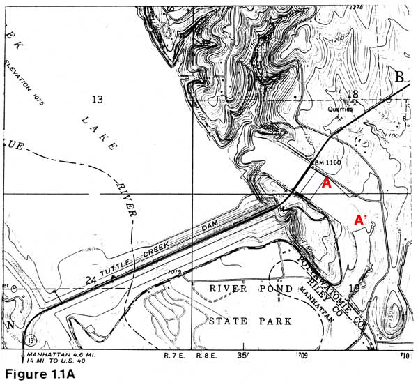
Abnormally heavy rainfall during the summer of 1993 in the drainage basin of Tuttle Creek reservoir in northeastern Kansas created a situation that required release of water via the flood gates of this reservoir. All eighteen flood gates were opened for seventeen days releasing up to 60,000 cubic feet of water per second during these seventeen days. The released water eroded a "canyon" downstream from the flood gates in the area shown in Figure 1.1A creating extensive lateral exposures of the rocks from the Burr Limestone Member (interval between numbers 10 and 11 in Figure 1.1B) of the Grenola Limestone to the lower part of the Hughes Creek Shale Member (interval between numbers 1 and 2 in Figure 1.1B) of the Foraker Limestone.
Because of the freshness of this new exposure and the previously unavailable lateral exposure of these rocks, a unique opportunity was available to study in some detail the exposed rock sequence. Tom Olszewski, a graduate student in the Department of Geology at Kansas State University, told me that a number of KSU geology students, both undergraduate and graduate, were interested in measuring and describing this sequence. Tom then asked if I would oversee, coordinate, and compile the efforts of this group of students; the result is this report. The students dubbed themselves the "Spillway Expeditionary Force" (a.k.a. Tuttle Creek Reservoir Dogs) and included: Steven Clamons, Jennifer Elick, Rachel Kelsey, Stephen Muehleisen, Thomas Olszewski, Alex Walter, and Debra Welch. Part 2 of this report, a measured and described section of the exposed rocks was the major effort of this group. Specific aspects of the exposed sequence were studied by two of the students. Jennifer Elick studied the layer of algal stromatolites at the top of the Howe limestone (Part 3 of this report). Stephen Muehleisen investigated the trace and rare-earth element content of the Bennett shale (Part 4 of this report). Additionally, Rachel Kelsey measured the orientation of some Aviculopinna valves preserved in the upper part of the Sallyards limestone (Part 5 of this report).
NOTE: Readers of this report might also be interested in Kansas Geological Survey Open-File Report Number 94-23 by Keith B. Miller titled "Tuttle Creek Lake Spillway Exposure: Cycle Patterns and Paleosol Profiles" [available online].
Figure 1.1 Geography and general stratigraphy below the flood gates at the Tuttle Creek Reservoir Spillway; 1.1A Area of study showing location of diagrammatic sketch of rocks exposed (Fig. 1.1B), taken from Tuttle Creek Dam, Kansas 1978 photorevised 7.5' U.S.G.S. Topographic Quadrangle; 1.1B Diagrammatic sketch of east side of Tuttle Creek Spillway exposure; numbers denote the following: 1 = water level late August 1993, 2 = top of Hughes Creek shale and base of Long Creek limestone, 3 = top of Long Creek limestone and base of Johnson Shale, 4 = top of Johnson Shale and base of Glenrock limestone, 5 = top of Glenrock limestone and base of Bennett shale, 6 = top of Bennett shale and base of Howe limestone, 7 = top of Howe limestone and base of Roca Shale, 8 = top of Roca Shale and base of Sallyards limestone, 9 = top of Sallyards limestone and base of Legion shale, 10 = top of Legion shale and base of Burr limestone, and 11 = top of Burr limestone.