New Cross Section
A new cross section showing the subsurface stratigraphy from
Gove to Harper counties in Kansas is now available from the KGS. The cross
section consists of two full-color plates, each of which measures 32 by
40 inches. One plate shows the cross section according to the different
rock types, or lithology. The other plate shows the cross section according
to the named rock units encountered. The cross section is based on the
correlation of 21 wells in Gove, Ness, Pawnee, Edwards, Pratt, Barber,
and Harper counties. Correlation of the wells was done by CORRELATOR,
a software package developed by KGS scientist Ricardo Olea. The cross
sections, published as KGS Technical Series 16, are available from the
Kansas Geological Survey, 1930 Constant Ave. Lawrence, KS 66047-3726 (or
call 785-864-3965). Copies are $10 per plate, plus $4.00 postage and handling.
Kansas residents should add 7.3% sales tax on the entire order.
New Bulletin Highlights Trace Fossils
A new KGS bulletin focuses on the fossilized tracks, trails, and burrows
found in the Pennsylvanian-age Stull Shale Member of the Kanwaka Shale,
described near the town of Waverly in Coffey County, Kansas. Paleontologists
Gabriela Mángano and Luis Buatois (at the Instituto Superior de
Correlación Geológica in Argentina), Ron West (Kansas State
University), and Chris Maples (Indiana University) collaborated on the
book, which identifies traces of 41 different organisms in the rocks.
By analyzing the trace fossils, the researchers identified the depositional
environment as an equatorial tidal flat that varied from a sand flat to
mud flat to a terrestrial environment to a river channel. Copies of Bulletin
245, Ichnology of a Pennsylvanian Equatorial Tidal Flat—The
Stull Shale Member at Waverly, Eastern Kansas, are available from
the KGS at the above address and phone number. Copies are $30, plus $5
for shipping and handling. Kansas residents should add 7.3% sales tax
on the entire order.
New
Publications
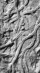
Trace fossil from Bulletin 245.
The first step
in tackling a problem is to understand it. Perhaps no issue is as important
to the people of the Great Plains as the depletion of the Ogallala aquifer.
Improving the understanding of that aquifer is the goal of the newly established
Ogallala Aquifer Institute (OAI).
Headquartered in Garden City, the OAI started in 2000 with funding from
the Kansas Water Plan. The Ogallala underlies parts of Kansas, as well
as New Mexico, Oklahoma, Texas, Nebraska, Colorado, South Dakota, and
Wyoming.
According to OAI coordinator Dana Woodbury, the OAI's aim is to coordinate
education and information about the aquifer, an effort that should lead
to better-informed decisions concerning the long-term management of the
Ogallala.
"I’ve been surprised by the level of support we have received from the other seven Ogallala aquifer states," said Woodbury. "They appreciate the fact that Kansas provides leadership in this area. While each state faces unique issues regarding the aquifer, everyone agrees about the need for fact-based, non-biased ground-water education and information."
Toward that end, Woodbury is collecting information about educational
and scientific efforts now underway in the eight states underlain by the
Ogallala. Eventually that information will be available over an OAI web
site. Strategic planning for future OAI projects will be undertaken by
the Institute's Board of Directors, composed of one member from each Ogallala
state.
For more information about the OAI, contact Woodbury at 312 E. Finnup
Drive, Garden City, KS 67846; phone 620-271-1554; or by email (dwoodbury@garden-city.org).
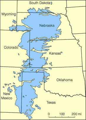
The extent of the Ogallala aquifer.
New
Institute
Promotes
Understanding
of Ogallala
Aquifer
URL:http://www.kgs.ku.edu/Publications/GeoRecord/2002/vol8.3/Page3.html