Spring 2000
Vol. 6.2
| |
||
| Kansas Geological Survey | Spring 2000 |
Vol. 6.2 |
|
Seismic Research at the KGS
CONTENTS Seismic Research–page 1 |
The
earth shook at the Lawrence headquarters of the Kansas Geological Survey
early this spring. It wasn’t a rare Kansas earthquake that rattled
windows and jiggled furniture. Instead, the vibrations came from a specially
designed truck called a seismic vibrator that Survey researchers were
testing outside the building. Seismic vibrators are one of the tools used in seismic reflection, a
technique commonly used in oil exploration which produces images of the
subsurface. Seismic reflection is a relatively noninvasive technique—that
is, it doesn’t require drilling into the earth to find out what’s
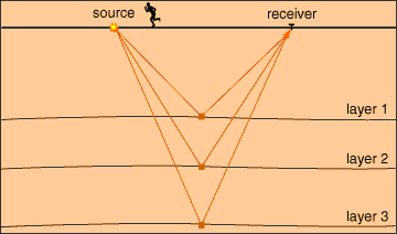
below the surface. Here’s how seismic reflection works. A vibration of some sort,
usually from an explosive device or a seismic vibrator, is put into the
earth. The energy travels as waves underground (much like waves on a pond),
reflects or echoes off rock layers, and bounces back to the surface where
it is recorded by microphone-like devices called geophones. Because different
rock types reflect the energy in different ways, the returning signals
can be processed by computers to produce an image of the underground rock
layers. “It works much like a sonogram or fish finder,” said Survey
geophysicist Rick Miller. “It’s a snapshot of what the rock
layers look like at a particular moment in time.” In recent years,
Survey researchers have experimented with seismic reflection techniques
to produce sharper images of subsurface features previously considered
too small to image, especially in the few hundred feet closest to the
surface. Survey researchers have applied seismic reflection technology to a number
of problems in Kansas. In Pawnee and Stafford counties, the technique
is being used to study sinkholes. These sinkholes developed in oilfields
where old wells allow water to move underground and dissolve away salt
layers, creating voids. At one sinkhole, the ground above the void settled
slowly. Twenty miles away, near Macksville, the earth dropped suddenly
in what geologists call a catastrophic collapse. By imaging the rocks
around and below these sinkholes, Survey researchers can get a better
feel for how sinkholes developed and what can be done to predict and remediate
them. At an industrial facility in Olathe, the Survey used seismic reflection to assist a study of potential ground-water contamination. Using high-resolution techniques developed at the Survey, KGS researchers were able to image the bedrock limestone eight to ten feet below an asphalt-covered ground surface. The three-dimensional map of the rock layers revealed a channel in the limestone, information that was used to guide the placement of monitoring wells to track potential contamination. “We can begin to identify underground flow paths and predict how contaminants will move, where they will spread,” Miller said. Survey researchers also use seismic reflection techniques to assist petroleum
research in the state. In a study near Elk City in Montgomery County,
seismic reflection is producing a two-dimensional image of rock layers
that occur 400 to 1,000 feet below the earth’s surface. Because
these rocks crop out at the surface about 15 miles away, the picture produced
by seismic reflection can be compared with the revealed rock layers. This
gives the Survey researchers a way to test the accuracy of their imaging
techniques, Miller said. “The thinner the rock layers we can image,
the better we can map small reservoirs of oil and gas that are now invisible
using conventional seismic techniques.” Seismic reflection is just one geophysical tool researchers use to learn about the rocks below the surface. “Eventually, we have to use invasive techniques to verify our interpretations, but tools like seismic reflection can help us use drilling more effectively,” Miller said. “Otherwise, it’s hit and miss, like throwing darts at a board.” |
|
Energy is put into the earth from a source, reflects
from each rock layer, and returns to the receiver after a certain amount
of time. |
 |
| Online February 10, 2003 Comments to: lbrosius@kgs.ku.edu Kansas Geological Survey URL:http://www.kgs.ku.edu/Publications/GeoRecord/2000/vol6.2/Page1.html |