Montgomery, Ness, and
Stafford Geologic Maps
New geologic maps of Montgomery, Ness, and Stafford counties are now available
from the Kansas Geological Survey. They are part of a series of new geologic
maps being produced by the Survey.
The maps depict the age and type of rocks at the earth’s surface
and show geologic features, such as faults and folds, in surface rock
formations. The maps also show roads, towns, rivers and ponds, railroads,
and other features.
The Montgomery County geologic map, based on field work by Tulsa geologist
Allan Bennison, updates a geologic map of the county done in 1974. It
includes two cross sections of the rocks beneath the county and a brief
discussion of the county’s geology. Most of Montgomery County is
covered by limestones, sandstones, and shales deposited during the Pennsylvanian
Period, about 300 million years ago.
Workers at Fort Hays State University—Ken Neuhauser, Tina Wilcox,
and Bruce Schumacher—compiled the Ness County geologic map. Most
of Ness County is covered by rocks deposited during the Cretaceous Period,
about 80 million years ago, and by much more recent deposits of loess
(wind-blown silt) and alluvium (water-deposited silt, sand, and gravel).
The Stafford County geologic map was compiled by Alan Arbogast, a former
geography graduate student at KU, and KU geographer William Johnson. Most
of Stafford County is covered by soils formed in sands and loess. These
materials were deposited during the last Ice Age, about 10,000 to 20,000
years ago. Since then, and even now, sand dune areas have continued to
change and move.
Each map is drawn at a scale of 1:50,000 (one inch equals about 0.8 of
a mile). The full-color maps measure 40 x 40 inches. Copies of the maps
are available from the KGS for $15.00 each, plus tax and shipping.
Kansas Water Levels Report
Water levels in the aquifers of western and central Kansas continued to
decline in 1995, though at a somewhat slower pace than the previous year.
These conclusions are based on the measurement of 1,500 wells across the
state in January 1996, by the Kansas Geological Survey, the U.S. Geological
Survey, and the Division of Water Resources of the State Department of
Agriculture.
The report, January 1996 Kansas Water Levels and Data Related to
Water-level Changes by Survey water specialists John Woods and Jeff
Schloss, shows depth to water for each well measured on a yearly basis
during the 1990’s. Copies are available from the KGS for $10.00,
plus tax and shipping.
Hugoton Natural Gas Area
The largest natural gas field in North America and second largest in the
world is the Hugoton field. Hugoton Natural Gas Area of Kansas,
a new public information circular by Tim Carr, Petroleum Research Section,
and Robert Sawin, Geology Extension, describes the history and geology
of the Hugoton gas area, its importance to the state, and how foresight
and stewardship will affect its future. This four-page circular was published
in January by the Kansas Geological Survey.
Copies of Hugoton Natural Gas Area of Kansas (Public
Information Circular 5) can be obtained free of charge by contacting
Publications Sales at the
KGS. It is also available electronically through the KGS
World Wide Web site.
KGS Catalogue of Publications
The 1996–97 Catalogue of Publications, featuring books
and maps that are currently available from the Survey’s Publications
Sales office, was published in December. Contact Publications
Sales at the KGS for a free copy.
New
Publications
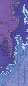
Segment of the Geologic Map of Montgomery County.
URL:http://www.kgs.ku.edu/Publications/GeoRecord/1997/vol3.1/Page3.html