Winter 1997
Vol. 3.1
| |
||
| Kansas Geological Survey | Winter 1997 |
Vol. 3.1 |
| Seismic Techniques Help Define Kansas Sinkholes
CONTENTS Seismic Techniques
|
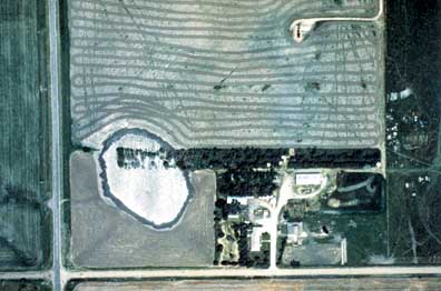
Drive
15 miles south of Ellsworth on Kansas Highway 14. East of the highway,
just before you get to the Ellsworth–Rice County line, you’ll
see a bowl-shaped depression, about 75 yards across and, at most, about
10 feet deep. The depression often holds water. Along one edge, trees
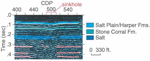
in a shelterbelt have sunk along with the ground. The depression’s source is about 600 feet underground, where ground
water has created a void in a layer of salt, causing the surface to slowly
settle. The Kansas Corporation Commission wanted to know if the depression—a
sinkhole—would continue to slowly expand, if the settling might
reach the highway, and if there was chance that the sink would collapse
suddenly. To find out, they needed to see beneath the surface, something
none of us can do without drilling a well. But seismic reflection, a technique
widely employed in the oil industry, offers images of the underground
without digging. By fine-tuning seismic reflection techniques, researchers
at the Kansas Geological Survey have produced a sharper vision of the
subsurface, especially the few hundred feet closest to the surface. Here’s how seimsic reflection works. A vibration of some sort,
usually from an explosive or a truck equipped with a special vibrating
pad, is put into the earth’s surface. The energy moves underground,
reflects off rock layers like an echo off a canyon wall, then bounces
back to the surface where it’s recorded by microphone-like devices
called geophones. The results, processed by computers, are images of underground
rock layers. “Seismic reflection is ordinarily used for finding oil and gas,”
said Survey geophysicist Rick Miller. “We’re usually looking
for pollution or void spaces, things that nobody wants to find, but they
need to know about.” The Survey’s seismic reflection techniques are often focused on sites of underground contamination. At the Cherry Point Marine Air Station in North Carolina, solvents spilled at the surface had reached a shallow aquifer. Using seismic reflection, the Survey provided an image of the near-surface geology, pinpointing the path of contamination and helping determine locations of new wells that could correct the problem. Since the early 1990’s, the Survey’s seismic-reflection group
has averaged about $300,000 per year in grant and contract work, much
of it for the Department of Energy and the Department of Defense. They’ve
experimented with various energy sources, from shotguns and sledgehammers
to vibrator-equipped trucks. “People come to us because we take the time to get better resolution
in our images of underground rock layers,” said Miller. “We
can show people details they’ve never seen before, except in road
cuts or cores from drilling.” In Kansas, the technique has been used to find abandoned coal mines,
shallow limestones that might hold oil, and the rock beds beneath sinkholes.
Many of the sinkholes in Kansas develop where old wells allow water to
move underground and dissolve away salt layers, creating voids. The ground
above usually settles slowly. Sometimes it drops suddenly, creating (in
the language of geologic hazards) a “catastrophic” collapse. “Seismic methods help reveal the configuration of rocks around
and below sinkholes, showing places where rock layers are altered or missing,”
said Miller. That information can help geologists predict the sink’s
behavior and help guide remediation. And the Ellsworth County sink? Seismic surveys in 1984 showed that it probably won’t fail catastrophically, but will continue to subside and grow, at the rate of a few inches per year. Twelve years later that’s proved to be the case. |
| Aerial photograph
of the sink in Ellsworth County. Kansas Highway 14 is at the photo's left
edge. |
 |
Seismic data from
the Ellsworth County sink, showing the settling of subsurface rock formations. |
 |
| Online February 10, 2003 Comments to: lbrosius@kgs.ku.edu Kansas Geological Survey URL:http://www.kgs.ku.edu/Publications/GeoRecord/1997/vol3.1/Page1.html |