![]()
Prev Page--Lower Cretaceous || Next Page--Niobrara
The Upper Cretaceous of Kansas
by W. N. Logan
With an Introduction by Erasmus Haworth
Contents
Geography
Topography
Dip
Divisions
Lower Group
Upper Group
Lignite Horizon
Salt Marsh Horizon
Gypsiferous Horizon
Dakota Stratigraphy
Paleontology
Dakota Water-bearing Strata
Geography
Stratigraphy
The Lower Group
The Bituminous Shale Horizon
The Lincoln Marble Horizon
The Flagstone Horizon
The Inoceramus Horizon
The Fence Post Horizon
The Upper Group
The Ostrea Horizon
The Blue Hill Horizon
The Salt Creek Gravel Beds
Septaria
Fort Hays Limestone
The Pteranodon
Section through the Cretaceous—Clifton to Colorado Line.
Benton Section—Beloit to Tipton
Fort Pierre Section—St. Francis to Arickaree River
Dakota Section—Brookville to Little Timber Creek
The Upper Cretaceous of Kansas
Introduction
by Erasmus Haworth
At the close of the Comanche period, already described by Professor Prosser, the outlines of the North American continent were well formed and were similar to the continent as now known excepting a narrow inland sea reaching from the southern part of the United States to beyond the limits of Canada, and probably connecting with the Arctic ocean. This inland sea separated the eastern part of the American continent from such portions of the great Cordilleras area as were elevated into dry land. The coast lines along the Atlantic coast and the Gulf of Mexico were considerably farther inland than they are at present, leaving a border averaging from a hundred to a hundred and fifty miles in width, which has since been elevated and has become a part of the continent. Plate XXV, a small sized map of the United States, has the approximate areas marked on it which were under water at the close of Comanche time and which subsequently had Cretaceous rocks formed over them. It will be seen that there was an arm of the ocean reaching northward from the western part of the Gulf of Mexico, passing through Texas, the Indian Territory, Kansas, eastern Colorado, Nebraska, the Dakotas, eastern Wyoming, and Montana. The same area probably reached far into Canada, or quite likely connected with the Arctic ocean. Throughout this relatively large area sediments were accumulating from the drainage of the dry lands on either side, and from the accumulation of matter from animal organisms, so that heavy deposits of sandstones, limestones, and shales were formed. These deposits are similar in many respects to those formed during the same time along the ocean borders of the Atlantic and the Gulf of Mexico.
Western Kansas and eastern Colorado represent the great central portion of this formation. It would seem that in some way ocean water remained over these areas longer than it did farther to the south, as they have younger rocks than can be found in some of the southern parts. Plate XXVI is a section drawn north and south near the west side of Kansas to represent the relative positions and arrangements of the various Cretaceous rocks which were formed during the time now under discussion. It will be noted that at the extreme south western part of the state the Dakota sandstone occurs at the surface. As one passes northward one finds the relatively thin edges of succeeding formations in the order of their deposition, first the Dakota, then the Benton, next the Niobrara, and later the Fort Pierre. Could this section be continued farther northwest it would show succeeding formations, the Fox Hill and the Laramie, belonging to the Cretaceous. So far as the indications in Kansas are concerned, therefore, it would seem that this great inland sea was drained to the north by the elevation of the continent being greatest on the south.
The study of the Cretaceous formations in the great inland area progressed slowly from the first excursions of Meek and Hayden in the 1850's until quite recent times. Slightly different systems of nomenclature have been suggested by different ones, each of which has had its advocates. They have more or less been abandoned, however, or combined, until at the present time it is customary to classify the upper Cretaceous rocks in the following manner:
| No. 5. Fox Hill Group | Montana Formation |
| No. 4. Fort Pierre Group | |
| No. 3. Niobrara Group | Colorado Formation |
| No. 2. Benton Group | |
| No. 1. Dakota Group | Dakota Formation |
Of these all but No. 5 are found in Kansas and are included in the following description.
The Dakota formation is interesting and peculiar in some respects on account of the strong indications in different parts of America that it is of fresh water origin. By descriptions given of it for both north and south of Kansas, it would seem to represent fresh water deposits, but here in Kansas it furnishes marine invertebrate fossils, and has other properties, such as salt and gypsum within it, which strongly imply that it was formed under ocean water. This formation is so largely composed of sandstone that it is frequently spoken of as the Dakota sandstone. It is probably true, however, that less than half of the thickness of the whole Dakota is sandstone, the remainder being different kinds of shales, of which clay shale is the most abundant. Lignite or brown coal is found in place in sufficient quantities to become an article of commerce. Other changes, perhaps equally great, imply that a detailed study would result in the subdivision of the Dakota into a number of groups or formations.
The Benton is largely composed of limestone, and is rich in marine fossils. Whatever may have been the character of the water under which the Dakota was formed it is certain that with the close of the Dakota ocean water covered the whole of the great inland area. The great abundance of shale in the Benton, constituting more than two thirds of the total thickness, shows how a large amount of earthy material was carried from the dry lands into this inland ocean. It is probable that the main portion of it was carried westward from the large continent lying to the east, although it is difficult to make positive statements regarding this. It is known that at this time portions of the Rocky mountain area existed as dry land covered with different forms of crystalline rock. The sediments in the whole of the Cretaceous of Kansas from the beds of the Comanche to the top of the Fort Pierre seems to be entirely free from any fragments of crystalline rock. This strongly implies that the drainage was westward from the Coal Measures of the great interior area.
With the close of the Benton Niobrara time was ushered in. During this period a less amount of sediment was carried oceanward from the dry lands, and a correspondingly larger amount of the Niobrara is composed of different forms of limestone. Why this decrease in the deposition of dry land sediment it is difficult to say. Probably it was due to the climatic change resulting in a less rainfall on the adjacent lands. However that may be, the conditions were such that the character of the limestone formed was very different from that found elsewhere in Kansas, or in America outside of the Niobrara. The great mass of the Kansas Niobrara is principally chalk, in some places being perhaps more nearly composed of microscopic organisms constituting true chalk than elsewhere. But all over the state, wherever the upper Niobrara rock occurs, a sufficiently large proportion of such organisms are found to give the limestone a chalky character.
During Fort Pierre time the conditions were again reversed as regards sediments from the dry land, almost all the Fort Pierre formations in Kansas being shales or shaly limestones which must have been produced by the accumulation of sediments brought down from the land areas. The climatology of Cretaceous time in Kansas is an interesting subject, one which might produce valuable results were it studied in sufficient detail.
The Upper Cretaceous
by W. N. Logan
In this Report will be given, first, a general discussion of the Upper Cretaceous of Kansas, and second, a number of sections which will serve to show the principal features of Upper Cretaceous stratigraphy.
Geography
Approximately the upper Cretaceous occupies in north central Kansas an area of twenty five thousand square miles-nearly one third of the total area of the state. The main portion of this area lies between the 38th and 40th parallels north latitude and the 97th and 100th degrees 30 minutes west longitude. The border lines of the area are very irregular. On all of the principal streams which flow through the formation outcrops occur far beyond the boundaries of the main area. On the Smoky Hill river they extend as far west as the Colorado line. The direction of the longitudinal axis of the group is from northeast to southwest. The eastern and western general boundary lines of each subdivision are nearly parallel. The boundary lines of the Dakota are the most irregular. Narrow arms extend almost through the Benton area in many places. South of Great Bend a probable northward movement of the Arkansas river has cut into and eroded away the Dakota rocks, making a great southern bend in the Dakota area.
There are many small Cretaceous outcrops lying in the great Tertiary area south of the Arkansas river that usually occur along the streams which have cut through the overlying Tertiary formation. Outcrops of the Comanche, a member of the Lower Cretaceous, occur along the border of the Red-Beds in the southwestern part of the state.
The width of the lower Cretaceous area is only a few miles in extent. The formation extends from near the northern part of Barber County along the western border, thence across Comanche and Clark counties to Meade county. These outcrops form narrow borders along the northern tributaries of the Cimarron in the above-named counties.
The outcrops of the Upper Cretaceous are found farther to the west. A small Dakota area occurs on the Cimarron river in the southwestern part of Morton county. A much larger area is found along the Little Cimarron in the northern part of the same county. A small area of Dakota occurs on a tributary of the Cimarron in the extreme southern part of Stanton County. A similar outcrop, is found a few miles north on Bear creek in the same county. The largest Dakota exposure occurs on a tributary of Bear creek, in the southern part of Hamilton County. The three outcrops last named extend into Colorado. They occupy a narrow strip on the banks of the streams.
The Benton is represented south of the Arkansas by a few small outcrops. A small area occurs in the southern part of Gray County. This is entirely isolated from the main body of the Cretaceous, being surrounded by the Tertiary formation. A similar outcrop is found about midway between Bear creek and the Arkansas river in Hamilton. Along the Arkansas river from Hartland, in Kearny County, beyond the western line of the state into Colorado, the Benton outcrops are almost continuous. They occupy here, as elsewhere in this part of the state, however, but a narrow belt along the banks of the river.
On the northern tributaries of the Arkansas in the same region, Niobrara exposures rest conformably on the Benton rocks. No outcrops of Niobrara are found south of the Arkansas, but a few isolated outcrops occur in the great Tertiary area north of that river. Two such instances are found in the southeastern portion of Scott County, which are probably the ones referred to by Hay as belonging to the Fort Pierre. [See Doctor Williston's report on the Niobrara, in this volume.] A larger Niobrara area is found in the western part of Greeley County, which is Fort Hays limestone and extends across into Colorado. Another small exposure of Fort Hays limestone is found along the tributaries of the Arkansas a few miles north of Coolidge on both sides of the state line.
Topography
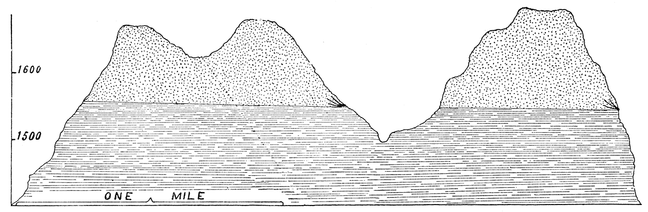
There is a marked similarity in general topographic features of the Cretaceous and the Carboniferous formations in Kansas. Between the Cottonwood Falls limestone of the Permian and the Lower Coal Measures we find four great limestone groups which serve to produce marked changes in topographic features. In the Cretaceous and the Tertiary areas above the Cottonwood Falls limestone we also find four rock formations which serve a similar purpose. The four members of the first group are, beginning with The lowest, the Erie limestone, the Iola limestone, the Garnett limestone, and the Oread limestone. The members of the upper group are, the Dakota sandstone, the Benton limestone, the Fort Hays limestone, and the "Mortar beds." Throughout the state wherever there is an exposure of anyone of these groups, similar irregularities of surface have been produced. Along the eastern border of each exposure mounds of shale protected by the more durable rock are found. Above the point where the limestone or sandstone disappears under the surface, a comparatively level but gradually ascending plain extends westward until the next limestone or sandstone group is reached, where nearly the same topographic features are repeated. Therefore in passing from the eastern part of the state to the west north of the Arkansas river, we ascend a number of terraces, each one having a very irregular border. Of these upper terraces, the Dakota presents the greatest diversity in topographic features, a condition due largely to the varying texture of the sandstone. The sandstone hills of the Dakota group are composed usually of thin bands of sandstone with intervening shale beds capped with a heavy thickness of sandstone. See Plates V, VI, XII, and XXIV.
The Benton area is more regular in topographic features. It contains a single chain of hills which extends from northeast to southwest through the central portion of the area, and are composed of the upper Benton shales, the Blue Hill shales, capped with the Fort Hays limestone. On account of the peculiar bluish appearance which they present when seen from a distance, they are called the Blue Hills. Their color is due to the dark blue shales of which they are composed.
The Fort Pierre shales in the northwestern part of the state are protected by the "Mortar beds." Many mounds similar to those in the Dakota and Benton areas are found.
Dip
The direction of the dip of the Cretaceous bed is toward the northeast. The altitude of the lowest Fort Hays limestone of the Niobrara on the Hackberry in Trego County is 2200 feet. The same stratum rests upon the Blue hills to the northeast in Mitchell County at an elevation of 1800 feet. This makes a difference of 400 feet in elevation for a distance of eighty miles, or a dip of five feet to the mile. A continuation of the same section from Ionia to Scandia produced relatively the same result. The altitude of Wallace in Wallace County, eighty five miles west of the Hackberry, in Trego County, is 3300 feet. Allowing 400 feet for the Niobrara and 100 feet for the Fort Pierre at Wallace, we have a difference in altitude of 600 feet, making a dip of seven feet per mile. Taking the elevation of Otego, in Jewell County, 1792 feet, and using the above data for Wallace, we find a difference in altitude of nearly 1000 feet in a distance of 170 miles, or a dip of six feet to the mile. The elevation of Beloit, in Mitchell County, at the extreme Upper Dakota is 1350 feet. The elevation of Santa Fe, in Haskell county, is 2950 feet. A well at Santa Fe passes through 324 feet of Tertiary and 13 feet of Fort Benton, giving an elevation for the upper surface of the Dakota at that point of 2611 feet. The difference in elevation of the Dakota at Beloit and at Santa Fe is therefore 1261 feet. The distance between the two points is one hundred ninety miles. Thus the dip is a little more than six feet to the mile for the upper surface of the Dakota in this direction. The Septaria horizon is found near Laird, in Ness County, at a height of 2300 feet. At Tipton, in Mitchell County, the same horizon occurs at an elevation of 1800 feet. Tipton is one hundred miles northeast of Laird and the difference in elevation is 500 feet, consequently the dip for the Fort Benton upper beds is five feet per mile.
These comparisons of elevation are sufficient to show that the dip of the Cretaceous beds does not exceed seven feet to the mile in any part of the state when measured over long distances. In different places, however, locally a much greater dip is found.
Divisions
[Note: For a discussion of the divisions of the Cretaceous see Introductton to this article.]
Three principal divisions of the upper Cretaceous are represented in Kansas. These divisions are: the Dakota, not divided; the Colorado, divided into two groups, namely, Benton and Niobrara; and the Montana, represented by a single group, the Fort Pierre. The vertical position of these divisions is shown by the accompanying vertical section, Plate XXVII. Beginning with the Permian, upon which the Cretaceous beds rest, the order of stratigraphic sequence is as follows: first Dakota, second Benton, third Niobrara, fourth, Fort Pierre. These groups will now be considered in the order in which they have been named and a few facts in regard to the geography, stratigraphy, economy and paleontology of each will be given.
The Dakota
The Dakota occupies a narrow belt along the eastern border of the Cretaceous area. It extends from Washington County on the northeast to Ford County on the southwest in one continuous area, and has a number of small outlying areas farther to the southwest, as already mentioned. Its greatest width is a line extending from the confluence of Big creek and the Smoky Hill river to the western line of Morris County. The narrowest portion of the belt is in Clay and Cloud counties. In the northern portion the Dakota beds rest upon the Permian gypsiferous shales, and in the southern upon the Red-Beds of the Permian.
The Dakota formation may be subdivided, but there are no well defined separating lines. For convenience of discussion, however, it will be divided into two groups; first the ferruginous or lower group; and second the saliferous shale group, or upper group. The layer of sandstone which underlies the upper shales will be considered the line of separation.
The Lower Group
The lower group consists of alternate layers of red and white sandstone, and argillaceous and arenaceous shales. In the southeastern part of the Dakota area these shales rest upon the Permian limestone; in the northeastern part upon a thin bed of gypsiferous shales which probably belong to the Permian. The shales of the lower bed are chiefly argillaceous, but near the sandstone layers they are frequently found to be highly arenaceous. In many places, especially in the strata adjoining the lignite veins, they are very bituminous. They are of many colors, but the color usually prevail, ing is a light blue. An outcrop in the Smoky Hill Buttes shows three bands of color, red, mottled and white. Small traces of lignite are found in the lower bed of shales, as are also thin layers of sandstone. Gypsum crystals are found usually near the middle of the bed. The maximum thickness of this lowest bed of shales is in the neighborhood of one hundred feet. The remainder of the lower group consists of alternate layers of shale and sandstone with the sandstone layers far exceeding the shales in thickness. The thickness of each layer of sandstone varies, however, in different parts of the Dakota area. Near the middle of the sandstone group is a layer from which many fossil leaves have been taken, but they are not always found at exactly the same horizon, their position varying as much as fifty or sixty feet. The best specimens have been collected in the eastern part of Ellsworth County, none having been found thus far in the northern part of the Dakota area. The sandstones of the ferruginous group rest on the lower beds. They probably reach their maximum thickness in the northern part of the area, and thin out toward the southern. They are highly ferruginous in character, and curiously shaped ferruginous nodules are of common occurrence. They vary in texture from the loosely cemented sand to the very coherent sandstone.
The Dakota sandstone is used for building purposes to only a limited extent. Representing approximately both extremes in the scale of hardness, they are either too hard to be dressed or too soft to withstand weathering. Another objection urged against their use as building stone is that of their color. Owing to the constantly varying amount in the quantity of iron oxide in the stones of the same quarry even, many shades of color exist.
Many peculiar effects of erosion are to be seen in the sandstone area. Standing on the hillside a few miles east of Ames, in Cloud County, is a single escarpment which has weathered into a form resembling an ancient castle. At Pawnee Rock, in Barton County, a similar outcrop stands sentinel over the Arkansas valley. Both owe their preservation to a protecting covering of the Benton limestone. The natural fortifications of Pete creek, in Washington County, are only equaled by those at Fort Riley. Soldier Cap Mound, in Saline County rises 140 feet above the surrounding country and consists of a single point of shales protected by a layer of sandstone. See Plate XXIV. The Smoky Hill Buttes are similar mounds in the southwestern part of Saline County, Plates V and VI. At Rock City, in Ottawa County, the sandstones have been eroded into peculiar rounded forms, resembling glacial boulders. The intersecting channels, with their inclosed forms, give to the group the appearance of a city, hence the name. With the exception of the spherical forms, similar groups occur in Lincoln, Ellsworth and Russell counties. In the majority of instances, the white sandstone rests upon the red; but in a number of instances they occur in the same horizon. East of Bavaria both were found in the same horizon, the one color passing gradually to the other.
The Upper Group
Lignite Horizon—Resting upon the gray or white sandstone, in the last upper layer of the sandstone group, is a thin bed of lignite which is entirely wanting in certain localities. The lignite varies in thickness from 6 to 26 inches. In Republic County it occurs from 80 to 100 feet below the Benton limestone. In Lincoln County it is only 60 feet below that horizon, and in Russell County it is 90 feet. The thickest vein occurs in the mines on Little Timber creek in Lincoln County where the lignite rests between beds of shale and gray sandstone, the shale adjacent the coal being extremely bituminous in character. In Republic County near Minersville, two 9 inch veins are intercalated with shales which are argillaceous, and not bituminous in character. Above the lignite bed in Mitchell County rests a thick bed of bituminous shales which seem to pass conformably into lignite. In Coal canyon thin layers of lignite are intercalated with sandstone and shale. The lignite is mined in this locality by tunneling into the drift of the creek bed. Shafts have been sunk to a depth of 80 feet in Republic County and 50 feet in Lincoln County. Lignite is mined and used for fuel in Republic, Mitchell, Lincoln, Russell and Ellsworth counties. The lignite contains much ash in the form of pyrite, shale, etc. The principal mines are located on Wolf creek and Coal canyon in Russell County; on Coal creek and Elkhorn in Ellsworth County; on Spillman creek, Little Timber creek, Bacon creek, Rattlesnake creek and Elkhorn creek in Lincoln County; on Rock creek and Solomon river in Mitchell County; on West creek in Republic and Cloud counties.
The strata adjacent the lignite vary with the locality. In some localities the lignite rests between beds of shale, in others between layers of sandstone, and still in other localities it is found resting upon sandstone and covered with shale. In many places it is, entirely wanting. Its place, however, may be occupied by a thin bed of bituminous shale.
Salt Marsh Horizon—Resting upon the lignite is a bed of shales which are, in the majority of instances, highly saliferous in character. They vary in thickness from 15 to 30 feet. By the disintegration of these shales salt marshes have been formed in many localities along the exposure of the upper Dakota horizon. The marshes occur on the Rattlesnake creek in Lincoln County; on Rock creek and Salt creek in Mitchell County; on Marsh creek in Cloud County; on West creek, Marsh creek and Salt creek in Republic County, and on Marsh creek in Jewell County. The saline properties of the Great Spirit spring, which is located in an outlier of the Dakota near Cawker City, are due to these shales. Salt springs occur in this horizon in Mitchell, Jewell and Republic counties, and the water of the wells which pass through the shales is invariably saline.
Gypsiferous Horizon—Above the saliferous shales is a bed of shales varying in thickness from 10 to 20 feet. These shales are thin, laminated and of loose texture. They contain quantities of gypsum crystals.
The gypsum shales are more numerous in the southern part of the district. Outcrops occur a few miles west of Lincoln Center, and near Buel, in Mitchell County. Gypsum is also found in the Little Timber and other mines. Above the gypsiferous shales a thin layer of sandstone occurs. This sandstone varies in thickness from 8 to 12 inches and occurs in from one to six layers. In some outcrops the sandstone rests between thin beds of gypsum, and is very fossiliferous. This sandstone marks lithologically as well as paleontologically the separation of the Benton from the Dakota.
Dakota Stratigraphy
The following records of outcroppings will serve to show the relative positions of the different layers of the upper horizon.
| Salt Creek Section: |
1st outcrop—
|
| Rock Creek Section: |
1st outcrop—
|
| Little Timber Section: |
1st outcrop—
|
Paleontology
The lower Dakota horizon is noted for the number and variety of its fossil plants, but with the exception of a few fresh water mollusks and the tracks of birds, no animal remains have been found. Among the plants the following genera are represented: Cessites (three species); Ficus (six species); Sassafras (four species); Diospyros (three species); Plantanus (? species); Leguminosites (one species); Juglans ( species); Protophyllum (? species); Laurus (one species); Aurus ( species); Rhanus ( species); Liriodendron (three species). Many pieces of fossil wood, and, in some instances the trunks of trees, have been found in the lower Benton. These undoubtedly belonged to the upper Dakota horizon.
In the upper Dakota group fossils have been found in three horizons. In the thin sandstone layers of the first shale bed the following fossils were found: Corbicula subtrigondis, Trigonarca salinaensis, Yoldia microcodonta, Crassatellina oblonga, Arcopagella macrodonta, Tellina subscitula, Corbicula?, Protocardia salinaensis, Cardium kansasense, Cyrena dakotensis, Margaritans nebraskacenses, Mactra siouxensis, Tellina modesta, Tellina?, besides several other forms not yet determined.
In the saliferous shale horizon was found a bed of fossils of which the following have been determined: Leptosolen conradi, Pharella dakotensis, Pharella?, Cardium kansaseneis, also a number of forms not yet determined. Altogether more than twenty five species have been found in the Upper Dakota.
Dakota Water-bearing Strata
There are two principal water sources in the Upper Dakota. Resting upon and beneath the saliferous shales are thin layers of sand or loosely cemented sand rock. It is through these layers that the so-called sheet water of the Dakota flows. Every where along the line of exposure of the Upper Dakota, from Washington County on the north to Ford County on the south, water flows from these sand beds, lying immediately above or below the shale horizon. In some places on account of the local dip of the underlying sandstone, the water is forced through the shales and comes to the surface in the form of salt springs. In one of the Republic County salt marshes an artesian flow was obtained with sufficient pressure to lift the water 12 feet high. The line of exposure may be traced by such local terms as "Willow Spring," "Spirit Spring," "Round Springs," "Salt Spring," "Marsh Spring," etc.
A number of views have been advanced to account for the source of the Dakota water. One is that it follows the Dakota from its position on the eastern slope of the Rocky Mountains. Another is that it is from the Tertiary sheet water. It is not improbable, however, that the source of a large part of the water is much nearer at hand than even the Tertiary formation.
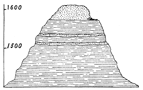
The Dakota sandstone is capable of storing a great quantity of water and of retaining it for a long period of time. The North Smoky Hill Butte, figure 10, furnishes an excellent example of this. This butte consists of a mound of shale rising one hundred feet above the neighboring surface and capped with layers of sandstone, forming with the intervening layers of shale an additional thickness of 125 feet. The upper surface of the Mound presents an almost level exposure of twelve or fifteen acres. At the point of contact between the lower shale bed and the sandstone the water flows out in the form of springs. The water from the springs flows the year round. The springs are located at the northeastern point of the mound, showing that the dip of the rocks is in that direction. It is clearly impossible for the water which supplies these springs to have come from a horizon below the sandstone; hence its source must have been the rain which fell on the surface. That capping of sandstone absorbed the water from the clouds and it trickles out from the upper surface of the shale as its own weight brings it to that level. Some idea of the amount of water stored may be gained from the fact that during three extremely dry years the supply of water in these springs did not fail once.
Figure 10—Smoky Hill Buttes; Upper Part Dakota Sandstone, Lower Part Shale.
Terra Cotta Mound, figure 11, is another excellent example of the storing power or the Dakota. This mound consists of a bottom layer of 100 feet of shale with 30 or 40 feet of sandstone resting above. Although its upper surface is only a few acres in extent, yet a never failing spring of water is found at the eastern extremity of the sandstone and shale conjunction.
Figure 11—Terra Cotta Butte; Upper Part Dakota Sandstone, Lower Part Shale.
The sand grains of the Dakota sandstone are rarely so closely cemented together as not to permit the free circulation of water. A few mounds of shale in Ellsworth County, however, are surmounted by a layer of sandstone the grains of which cohere so closely that the water is shed and very little, if any, stored.
The Benton
The dividing line between the Dakota and Benton is marked lithologically by the change from sandstone to shale, or from bituminous to argillaceous shale.
Geography
In geographical extent the Benton is the largest of the Cretaceous groups. It extends from the north line of the state in Republic County to Ford County on the southwest. With the exception of two small outcrops, one in Hamilton and one in Gray County, the Benton area lies. north of the Arkansas river. It seems to be conformable with the Upper Dakota, and the dip of its strata is toward the northeast.
Stratigraphy
[Note: For reasons that will be evident from the discussion of the Benton, the nomenclature of that group employed by Prof. F. W. Cragin in his paper, "On the Stratigraphy of the Platte Series," has been somewhat changed.]
Lithologically the Benton may be divided into two groups, viz., the lower, or limestone group [Russell Formation—Cragin], and the upper or shale group [Victoria clays—Cragin]. The lower group includes all the limestone and the interbedded and underlying shale. The upper group includes all the shales above the limestone group and below the Fort Hays limestone of the Niobrara.
The Lower Group
The lower group contains five principal horizons, namely:
- Bituminous shale;
- Lincoln Marble; [On stratigraphy of Platte series—Cragin]
- Flagstone;
- Inoceramus;
- Fence-post. [On stratigraphy of Platte series—Cragin]
The entire thickness of this group is from 90 to 130 feet. The indications are that the group thins out toward the south.
The Bituminous Shale Horizon—The shales comprising this horizon vary in thickness from 20 to 40 feet. They are dark blue in color and somewhat slaty in structure. Upon weathering they present ft laminated appearance. In many places they extend upward toward the next horizon gradually changing color from blue to yellow. Very few fossils are found in this horizon, Inoceramus liabatus being the most abundant.
The Lincoln Marble Horizon—Resting conformably upon the bituminous shales is the Lincoln Marble horizon. This group consists of from two to five layers of hard flinty limestone intercalated with shales. The maximum thickness of the group is 15 feet. The maximum thickness of the individual layers is 6 inches. The Lincoln Marble is of a bluish gray color, contains many impurities, is porous, hence weathers easily. It contains abundant evidence of vertebrate fossil remains, Fossils not yet fully identified, but what seem to be remains of Plesiosaurus and tracks of other saurians, have been found. Squaladont selachin shark teeth abound, as many as a dozen having been found under a single square foot of surface. The invertebrate forms are numerous. Inoceramus umbonatus, Inoceramus undabundus, and other forms, as yet undetermined, have been found.
The Flagstone Horizon—The Flagstone horizon rests conformably upon the Lincoln Marble. It consists of three or four layers of limestone with intervening shale. The maximum thickness of the group is 10 feet. The maximum thickness of the individual layers is 8 inches. The fossil forms in this horizon are not numerous. Remains of fish, shark teeth and invertebrates, of the genus Inoceramus, have been found. The limestone is white in color and fine in texture. It is used throughout the Benton area for flagstone, hence the name.
The Inoceremus Horizon—The Inoceramus horizon is nearly midway of the limestone group, and rests conformably upon the Flagstone horizon. The average thickness is from 4 to 5 feet, and consists of from one to three layers of limestone separated by argillaceous shale. The average thickness of the individual layers is 6 inches, The limestone is composed almost wholly of Inoceramus problematicus) and resembles a mortar bed into which shells have been thrown. The Inocerami casts are well preserved, and, although found throughout the upper limestone group, are most abundant in this horizon. For this reason the name Inoceramus has been given to the horizon. The shell rock, or lime rock as it is called locally, is used to a limited degree in the manufacture of lime.
The Fence-Post Horizon—Near the top of the limestone group is the Fence-post horizon, so named because the limestone is used very extensively for making fence-pests. It is estimated that there are at least fifty thousand of these posts in use in Mitchell and Lincoln counties alone, five thousand being used in a single township. Their use is becoming general throughout the Benton area. The average thickness of the fence-post limestone is 9 inches. A ferruginous seam passes through the center of the layer and by splitting the limestone along this seam excellent flag-stones are produced. The fossils found in the Fence-post horizon are chiefly invertebrates. Species of the genera Aspidorhynchus and Osmeroides have been found. With the exception of the Inoceramus group the limestone from each of the horizons is used for building purposes.
The Upper Group
The upper group contains two horizons, namely, the Ostrea shales, and the Blue Hill shales. This group represents a total thickness of 250 feet.
The Ostrea Horizon—The Ostrea shales rest conformably upon the Fence-post horizon of the lower group. They consist of a bed of argillaceous shales of variegated colors, from 100 to 150 feet in thickness. The characteristic fossil of this horizon, from which it has been named, is the Ostrea congensta beds of which occur throughout the horizon. These shells are usually found adhering to the bivalve Haploschapa capax. Remains of squaladont selachians and sestrationt selachians have also been found. In certain localities the shales are somewhat saliferous, forming wherever exposed, salt pans or licks. These pans are never of very large area and are usually recognized by their whitish appearance. In the extreme upper horizon the Tennuicarinata serpula is the chief fossil form.
It is the disintegrated Ostrea shales that form the soil for the major part of the Benton area. The soil so formed on account of the great quantity of Ostrea shells is very productive. The shales as a rule, however, are closely textured, so that there is a tendency to the formation of a subsoil which bears among agriculturists the name of "hard-pan." The hard-pan not only prevents the disintegration of the shales below, but becomes almost impervious to water, so that when water falls upon the surface of the ground and sinks through the stratum of soil to the surface of the hard-pan it flows along this surface until it reaches some neighboring outlet. Hence, instead of being stored up in the soil it is drained away and in a short time, the soil not being very deep, that part which remains has evaporated and the crops suffer as a result.
The Blue Hill Horizon—The Blue Hill shales, unlike the Ostrea shales, are very loosely coherent, and easily removed by erosion. Wherever they have covered the surface they have formed a very unproductive soil which is called locally "gumbo." The unproductiveness of the soil is due to the unfossiliferous character of the shales. The Upper Benton shales are preserved from erosion in the central portion of the Benton area by the massive Fort Hayes limestone of the Niobrara. Shales not protected in, this way have been eroded away leaving the protected shale beds with nearly perpendicular walls.
The maximum thickness of the Blue Hill shales is 100 feet. They are dark blue in color and nonfossiliferous. Williams Butte, a single isolated point among the Blue Hills, forms an excellent example of the erosion of the upper shale beds. It is 120 feet in hight, and is protected by the Fort Hayes limestone.
The Salt Creek Gravel Beds—The Salt Creek gravel bed, or conglomerate gravel stones, were at first difficult to account for. Chiefly owing to their resemblance to the grit rock of the Tertiary, they were thought to belong to that formation. They belong more probably, however to a later period. This gravel horizon is about 15 feet above the saliferous shales of the Upper Dakota, which form the bottom of the creek bed. The beds dip under the sail towards the bluffs, which are protected by the Benton limestone. An examination of the rock showed it to be composed of gravel, ferruginous nodules, etc., from the shales and limestone beds of the upper horizon. Herein, undoubtedly, lies the explanation of the origin of the gravel beds. By the disintegration of the shale, and the dissolving of the limestone, the gravels accumulated along the bed of the stream. Subsequently the stream changed its course, and the detritus from the bluffs filled up the old bed of the stream. After cutting down to a lower level the stream again changed its course, and exposing the old gravel beds which had, in the meantime, been cemented into firm rock.
The Niobrara
Septaria—The Niobrara group occupies a narrow belt along the border of the Tertiary area and overlies the Benton. Its total thickness is between 350 and 400 feet. Lithologically it has been divided into two groups: the lower, or Fort Hayes limestone; and the upper, or Pteranodon beds, or Smoky Hill chalk [Since Pteranodon has been shown to be synonymous with Ornithostoma, some think the latter name should be used.].
Besting upon, and often embedded in, the black shales of the upper Benton horizon, is a layer of shale containing many calcareous concretions to which the name Septaria has been given. It marks the dividing line between the Benton and Niobrara. This zone reaches entirely across the Benton-Niobrara area from Jewell County almost to the Arkansas river. The nodules are usually in the shape of flattened spheres, and their surfaces are either smooth or seamed. Some of them are solid, others are hollow, and the cavity lined with a crystalline substance, usually calcite. The calcite crystals vary in color, from a dark wine color to transparent. At the base of Williams' Butte, in Mitchell County, a field more than ten acres in extent is covered with the concretions, some of which are more than four feet in diameter. Many tons of them have been hauled away for museum specimens, or lawn ornaments. Some fine specimens of ammonites and scaphites have been found in them. Testudinates have also been found in that horizon.
Fort Hays Limestone—The Fort Hays limestone forms a continuous line along the bluffs of the Smoky Hill river, from the mouth of Hackberry creek to the western line of Ellis County. Here it disappears, but reappears as a capping for the Blue Hills in Russell, Mitchell and Republic counties. Its total thickness is 50 or 60 feet. A single escarpment on the Hackberry measures 45 feet. It rests upon the Septaria and upper shale bed of the Benton. The Fort Hays limestone is used to a limited extent for building purposes. When taken from the quarry it is very soft, therefore, easily cut, or sawed into any desired form. Under exposure it hardens somewhat, but is considered too soft to be very valuable as a building stone.
The Pteranodon Beds—The Pteranodon beds, or Smoky Hill chalk, rests upon the Fort Hays limestone. These beds represent a total thickness of more than 300 feet. They vary in color from a light blue, through lavender, yellow and buff, to light red. Under fresh exposure the chalk, in many instances, presents the appearance of a blue shale, and sometimes has been taken as such by persons doing geological work in western Kansas. These freshly exposed beds, however, under the weathering influences of air and water, soon change their shale, like appearance and their blue color to red, yellow, or buff, due probably to a change in the character of the iron compounds in it. In an exposure of chalk northeast of Lebanon, in Smith County, the chalk had a laminated appearance, and was blue in color in all parts except along the borders of five vertical fractures where it was the ordinary buff. The action of the surface water, as it passed along these crevices, probably accounts for the bleached appearance of the chalk along the border of the fractures. In passing up the Smoky Hill river to the state lim the exposures near the river bed are found to be blue in color, while those back on the bluffs are variegated. Wells which pierce the Tertiary deposit, lying immediately above the Pteranodon beds, usually strike blue chalk. That they do not always do so is easily explained when we remember that there was a period of erosion preceding the deposition of the Tertiary formation, which may have resulted in the bleaching out of much of the chalk.
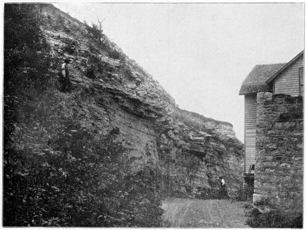
In a few places the chalk beds carry large amounts of chert which seem to be interstratified with the chalk. This is well represented at Norton, along the Prairie Dog creek. Northwest of the town about a mile the chert is quarried to a considerable extent. Plate XXVIII shows this, and Plate XXIX shows the same chert capping a chalk bluff at the old mill, Norton.
Plate XXVIII—Quarry in Niobrara Chert, one mile northeast of Norton. (Photographed by Haworth, 1896.)
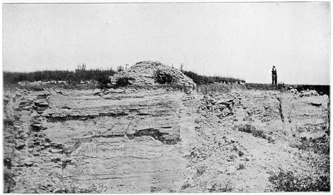
Plate XXIX—Niobrara bluff capped with chert, at old mill, Norton. (Photographed by Haworth, 1896.)
Some excellent mineral pigments have been taken from the chalk beds near WaKeeney to be used in the manufacture of paints.
Erosion has produced many peculiar forms in the Smoky, Hill chalk beds. Near Hackberry creek, in Gove County, is a mound of chalk 70 feet in hight, known as Castle Rock, and shown in Plate VII. It stands on an open terrace a few rods from the bluffs. In form it resembles an ancient castle, hence the name. Near Elkader is a group of these chalk forms which because of their pyramidal shapes are called the Pyramids; see Plate XXXV. "Castle City" is the name of a group which is situated near the western line of Gove County. The highest of these chalk mounds is nearly sixty five feet. Erosion within the chalk area is rapid and large quantities of chalk are carried a way by each freshet.
The chalk beds of Kansas are particularly rich in fossil remains, a synoptical review of which by Doctor Williston follows this paper.
The Fort Pierre
[Note: In his paper, "On the Stratigraphy of the Platte Series" Colorado College Studies, 1896, Prof, F. W, Cragin classes the Arickaree shales as Fox Hill, They were first called Fort Pierre by Prof, Robert Hay in his paper on: "Water Resources of a Portion of the Great Plains," published in the Sixteenth Annual Report of the Director or the U, S. Geological Survey.]
Resting upon the Pteranodon beds in northwestern Kansas is a bed (If shales which belong to the Fort Pierre group of the Montana Cretaceous. Outcrops of these shales occur on the Beaver in Rawlins County, the Prairie Dog, in Norton, and on the Hackberry, Republican and Arickaree in Cheyenne County. The upper shales are dark blue in color, argillaceous, chaffy and loosely textured. The next band is variegated in color, but usually of a rusty yellow. These shales contain nodules of a flat, disc-like shape. The freshly fractured surface of these nodules presents a bluish gray color, but the outside is like the shales, of a yellowish color. These nodules sometimes contain invertebrate fossils.
The maximum thickness of the Fort Pierre shales in Kansas does not exceed 200 feet. The principal invertebrate fossils of the Fort Pierre group are: Avicula fibrosa, Inoceramus cripsii, Lucina occidentalis, and Baculites ovatus. Undetermined species are from the genera Ostrea, Corbula and Scapliites. [Mr. T. W. Stanton, of the U, S, Geological Survey, kindly determined these species for the University in the Autumn of 1896.]
A Section through the Cretaceous from Clifton to the Colorado Line. Plate XXX, Figure 1.
Beginning at Peach creek a few miles east of Clifton, we find a bed of blue shales resting upon 6 feet of Permian limestone. Above a bed of sandy gypsiferous shales rests conformable with the blue shales, On the east side of Peach creek a line of Dakota sand hills rise to a height of 125 feet. These hills are composed of alternate layers of shale and sandstone and are invariably capped with from 10 to 25 feet of sandstone. The surface west of Peach creek rises gradually to a height of 50 feet above the creek bed. The sandy character of the soil indicates that the formation is Dakota, but there are few outcrops. The wells of this locality pass through sand and shale to the upper surface of the Permian limestone, along the surface of which the water flows.
Passing westward from Clifton to Clyde there are found a few outcrops of sandstone. The individual layers vary in thickness from 2 to 3 feet. The sandstone is of a brown color and loosely textured. In a railroad cut east of Clyde the following condition of strati, graphy was exposed. numbering from the bottom of the cut:
- 5th, Soil, 1 1/2 feet.
- 4th, Red sandstone, 10 feet, friable.
- 3d, Blue clay, shale, 10 feet.
- 2d, White sandstone, 2 1/2 feet, compact
- 1st, Blue clay, 1 foot, nonfossiliferous.
The valley of the Republican from Clyde to Concordia is bounded by the Dakota sandstone bluffs. These bluffs are composed of alternate layers of red or white sandstone and shale, and owe their preservation to the sandstone layer which rests upon them. West of Concordia the Upper or Lignite division of the Dakota is reached. The bluffs on each side of the river are capped with Benton limestone. The coal shafts at Minersville pass through 70 feet of gypsiferous and saliferous shale, and reach two 9 inch veins of lignite, intercalated between beds of shale. On the bluffs above the mouths of the shafts, the Benton limestone rests, the intervening distance being occupied by the lower Benton shale. North of Minersville, on West creek, the overlying shales of limestone have been removed by erosion, leaving the saliferous shales exposed. The latter, by weathering, have formed a salt marsh of several hundred acres in extent, An upward pressure of the water in the underlying Dakota strata has caused, in many parts of the marsh, the shales to assume the character of muck. A well was bored in this marsh to a depth of 150 feet. The water, owing to a local dip of the underlying strata, rose above the surface to a height of 12 feet. A salt marsh twelve hundred acres in extent occupies the same horizon on Buffalo creek, northwest of Jamestown.
Benton—In passing up the valley from Concordia to Jamestown, the last Dakota outcrop toward the southwest occurs a, mile east of Jamestown. Rut farther toward the west, on Buffalo creek, outcrops of Dakota sandstone are of frequent occurrence. The surface of the country from Jamestown to Scottsville rises gradually, passing through the lower Benton formation. The Benton limestone is found everywhere capping the hills south of Jamestown, but disappears under a gradually thickening bed of the Ostrea shales as Scottsville is neared. All of the horizons of the Benton limestone are marked, but the Lincoln marble is less distinctly marked here than elsewhere, and in some outcrops seems to be wanting altogether. One outcrop shows seven layers of. limestone varying i.n thickness from 2 to 9 inches, and intercalated with yellow rather closely textured shales, which contain the Ostrea congesta. From Scottsville to Beloit the slope of the country is toward the east and south. The Ostrea shales cover the surface, but many of the streams have cut down to the lower Benton, or the upper Dakota. On West Asher creek in an exposure of 37 feet, are fourteen layers of Benton limestone, intercalated with shales. This limestone disappears under the Ostrea shales farther to the north. The limestone layers vary in thickness from 2 to 6 inches, and the shale beds from 6 inches to 2 feet. The most characteristic fossil of the limestone is the Inoceramus liabatus.
The Upper Dakota appears on the Solomon river at Beloit in a layer of sandstone from 2 to 3 feet in thickness, resting on a bed of blue colored shale. The sandstone strata is very fossiliferous. Over the surface of the shale and through the sandstone flows the water with which the city is supplied. The thin stratum of sandstone contains many of the fossil forms described by Meek as belonging to the Dakota, and later by Cragin as to the Mentor beds. The bluffs on each side of the Solomon river are covered with layers of Benton limestone. Near Solomon Rapids the following section may be observed, numbering from the bottom:
- 4th, Alternate layers of limestone and shale, 20 feet.
- 3d, Limestone, 1/2 foot, Inoceramus liabatus.
- 2d, Limestone (Lincoln Marble), 5 feet. Shark's teeth abundant.
- 1st, Bituminous shale, 40 feet.
The Lincoln marble contains abundant remains of shark's teeth, and is about the same thickness as that found fifteen miles south on Salt creek.
In a railroad cut at Glen Elder the following order of stratigraphy may be observed, numbering from the bottom:
- 10th, Soil, 2 feet.
- 9th, Limestone, 8 inches.
- 8th, Shale, 2 feet, yellow color, Ostrea congesta.
- 7th, Shale and limestone, alternate layers, 20 feet.
- 6th, Limestone, 4 inches, Inoceramus horizon.
- 5th, Shale, 6 feet.
- 4th, Limestone, 3 inches, white.
- 3d, 2 feet of shale, light blue, with Inoceramus.
- 2d, 4 inches of blue colored limestone resembling shale in texture.
- 1st, 10 feet of black shale closely textured.
Passing north from Glen Elder the Benton limestone which is found on the bluffs at that point rapidly disappearing under the gradually thickening Ostrea shales. These, in turn, disappear under the Blue Hill shales, which, twelve miles north, in the vicinity of Iona, are capped with the Ft. Hays limestone of the Niobrara. Farther toward the north, in the vicinity of Burr Oak, the Pteranodon beds rest on the Ft. Hays limestone.
South of Glen Elder the Benton limestone disappears under the Ostrea beds and outcroppings are seen only along the streams. The country is comparatively level, with a gradual slope, until the hills are reached, when there is a rapid ascent of from 100 to 200 feet. The Blue Hills rest upon the Ostrea beds and are composed of the Blue Hill shale, capped by a layer of Ft. Hays limestone, The surface rises gradually from Glen Elder westward and the principal exposures are of the Ostrea shales. The Niobrara is reached near the confluence of Oak creek and the Solomon river numerous nodules of the Septaria horizon being found along its bed. In the neighborhood of Kirwin Pteranodon outcrops become more numerous, These Pteranodon beds contain Inoceramus deformis and Ostrea congesta. The plains marl of the Tertiary is also found to the north and south, but there are no outcrops of the mortar beds. Along the Solomon river the outcrops of the Pteranodon beds are numerous, but disappear under the Tertiary formation in Norton county.
The Tertiary—The thickness of the Tertiary formation is measured by the depth of the wells. The mortar beds are found resting upon the chalk beds of the Niobrara in the eastern and central portions of the Tertiary area, and toward the western line of the state upon the shales of the Ft. Pierre formation. The mortar beds consist of coarse sands cemented by a calcium carbonate cement. The plains mad is composed principally of clay, mixed with calcium carbonate, The maximum thickness of the Tertiary is about three hundred feet. The composition of the water-bearing stratum differs with this locality. In many places it is a fine grained sand, while in other localities it is found to be either coarse gravel, or gravel and sand mixed. The mortar beds are wholly wanting in some places. In Jewell County a narrow tongue of the plains marl extends between the White Rock and the Republican to the eastern border of the county, but the mortar beds are not found in the county. The sheet water here flows over a stratum of the impervious shale, or chalk, the dip of the surface of which is toward the northeast and, consequently, the flow of water is in that direction. In many places where the streams have cut down below the level of the shale bed, the sheet water flows out in the form of springs.
Section through the Cretaceous from Abilene to the Colorado Line. Plate XXX, Figure 2
On the bank of the Smoky Hill river, a few miles west of Abilene is the last westward outcrop of the Permian limestone. The formation above is sand from the disintegrated sandstone of the Dakota. It is 'Very probable that the shales which did overlie the Permian limestone have been eroded away and the valley filled in with sand from the surrounding sandstone. Sheet water from the Dakota flows over the surface of the Permian limestone, and is reached in the valley at a depth of from 12 to 30 feet. Toward the west the surface rises gradually, and the outcrops are sand or loosely cemented sandstone. Between Solomon City, and (Salina, along the Smoky Hill valley, the soil presents the appearance of disintegrated Permian shale, but no outcrops occur. West of Salina, in the neighborhood of Mentor, small outcrops of sandy shale, intercalated with thin layers of sandstone occur. These sandstones contain, according to Meek, the following invertebrate forms: Corbicula subtrigondis, Trigonarca salinaensis, Cardium kansasense, Cyrena dakoteneis, Margaritans nebrasacenses, Mactra siouxensis, Tellina modesta, Pharella dakotensis, etc.
Southwest of Mentor, in the vicinity of Salemsburg, is a row of hills called "The Smoky Hill Buttes." The Buttes are from 200 to 240 feet high, and consist of almost equal thicknesses of shale and sandstone. The sandstone occurs at the top. The shales are bluish white and contain iron ore nodules and traces of lignite. The character of the shales do not differ in any respect from those found in the upper Dakota. A well one fourth mile north of the Buttes, reaches the Permian limestone after passing through a bed of red shale, which undoubtedly belongs to the Permian. On the hills west of Salina the red and white sandstone occur in the same horizon. Farther to the southwest, on Sharp's creek, in McPherson County, the red beds are overlaid by a bed of shales which contains a shell bed of undoubted Kiowa fossils. The cone in cone structure, so common in the Dakota area, lies above this shale bed. At Brookville a well 38 feet deep passes through 26 feet of blue shale and 12 feet of Permian limestone. Above the blue colored shales, on the surrounding hills, the Dakota sandstone occurs. In passing up the creek from Brookville to Arcola, we notice a narrow valley, bordered on each side by shale banks, capped with sandstone. One of these shale banks measured 100 feet, being composed of 80 feet of shale, overlaid by 20 feet of sandstone. No fossils were found, but gypsum crystals, so characteristic of Upper Dakota shales, were abundant. One mile west of Terra Cotta a 10 foot outcrop of white sandstone is covered by a 25 foot bed of yellow, to purplish shales intercalated with thin layers of red or yellow sandstone, containing fossil leaves. A few rods to the south a hill 120 feet high is composed of alternate layers of sandstone and shale. Beginning at the top we find
- 4th. 25 feet of sandstone, yellowish brown.
- 3d. 25 feet of shales, with thin layers of sandstone.
- 2d. 10 feet of white sandstone, compact.
- 1st. 60 feet of shales and sandstone.
The country from Terra Cotta to Ellsworth is very broken and the land is used chiefly for grazing purposes. A well one and a half miles west of Terra Cotta passes through 40 feet of shale and sandstone to a layer of white sandstone through which the sheet water flows. A hill rises 60 feet above, and is capped with brown sandstone. A well one half mile south passed through a 6 inch vein of lignite in the same shale horizon.
Benton—On the divide between Lincoln Center and Ellsworth, the first Benton limestone is found. It covers the Dakota sandstone hills along this divide and gradually approaches the Smoky Hill river. In Russell County it is found capping the first bluff of that river. South of the Smoky Hill river the line of contact between the Benton and Dakota passes off toward the southwest through the northern part of Barton County and across Pawnee County into Ford County to its southern limits. It passes toward the north through Lincoln, Mitchell, Cloud and Republic counties. The last Dakota outcrop on the Smoky Hill river is found near the confluence of Big creek in the western part of Russell County. From the mouth of Big creek to the mouth of the Hackberry, we pass through the divisions of the Benton, in their order, from lowest to the highest.
The Limestone Group—The Benton limestone is found in many outcrops in the eastern part of Ellis and the western part of Russell counties. The Benton area may be recognized by the stone fence posts which are used in these localities. These fence posts are taken from the Fence-post horizon of the Benton group. The majority of the houses in this area are built of the Benton limestone.
The Ostrea Shales—The Benton limestone is superseded by the Ostrea shales. These shales contain here, as elsewhere, the characteristic Ostrea congesta and gypsum veins. Many outcrops occur along the river west of Mungor, and the surface of the country lies within the Ostrea horizon.
The Blue Hill Shale—The Blue Hill shales which overlie the Ostrea shales occur in banks along the river from White Rock to the mouth of the Hackberry. They everywhere underlie a bed of Ft. Hays limestone. At Cedar Bluff, a 50 foot bed of Blue Hill shales is overlaid by a 30 foot bed of Fort Hays limestone. At the mouth of the Hackberry a 45 foot ledge of Ft. Hays limestone rests upon a bed of Blue Hill shales in which the Septaria concretions are embedded. The Septaria marks the dividing line between the Benton and Niobrara, Passing up the Hackberry we find the Ft. Hays limestone overlaid with chalk cliffs, varying from a few feet to 100 feet in thickness.
The Niobrara—These chalk beds with the underlying Fort Hays limestone belong to the Niobrara formation. The outcrops of the chalk, or Pteranodon beds are almost continuous from a few miles above the mouth of the Hackberry to the western line of the state. The famous Castle Rock, see Plate VII, a single chalk mound 70 feet high, is located on the Hackberry about seven miles from its mouth. The Pteranodon beds occupy the country along the Smoky Hill river a distance of from one to three miles on each side from near the month of the Hackberry to Russell Springs. The hills back from the river are covered with the Tertiary formation. From Russell Springs to the state line the outcrops occur only at the river's banks and become less and less frequent as the line is neared.
The Benton Section from Beloit to Tipton, Plate XXXI, Figure 1.
Starting at Beloit and passing to the southwest a distance of twenty rive miles, we cross the exposed surface of each of the Benton divisions. The altitude of the Upper Dakota stratum at Beloit is 1350 feet, and the altitude of the highest Benton stratum on the Blue Hills is 1850 feet, making a difference in altitude, for the twenty five miles, of 500 feet. About 50 feet above the Upper Dakota horizon appears.
The Benton Limestone Group—The Benton limestone group here consists of layers of compact white limestone, intercalated with bands of yellow shale. On the bluffs south of Beloit the Benton limestone appears and disappears a few miles back under the Ostrea shale, The surface soil rests upon the Ostrea shales from this point to the base of the Blue Hills.
The Ostrea Shales—The Ostrea shales underlie the surface soil of the greater part of Mitchell, Jewell, Cloud, Lincoln, and Russell counties. The upland areas of these counties have almost as fertile a soil as the bottom lands, a condition due largely to the Ostrea shales.
The Blue Hill Shales—Near the base of the Blue Hills we find the lower horizon of the Blue Hill shale, and at the top the upper horizon containing the Septaria. A rather heavy deposit of Ft. Hays limestone rests upon the shales and prevents their erosion. The shales here do not differ from those found in other localities.
The Fort Pierre Section from St. Francis to the Arickaree River. Plate XXXII, Figure 1.
At St. Francis the Fort Pierre shales are very near the surface. St. Francis is located in the valley of the south fork of the Republican, which has cut down into the Tertiary a distance of from 150 to 200 feet. The surface of the Fort Pierre bed is very uneven at this point as indicated by the records of the wells, One well pierced the shale at 8 feet without reaching water, but another one only a few feet to the west, passed through 16 feet of sand and gravel without striking shale. and found abundance of water. Another well was dug, one half passing through shale the other half through sand. Water was found in this well but it was rendered brackish by contact with the shale. Another well pierced the Fort Pierre shales to a depth of nearly 200 feet. On passing from St. Francis towards the northwest we find the surface rising at first rather abruptly for 150 feet, then gradually to 250 feet above St. Francis. This difference in altitude is occupied by the Tertiary formation and the wells measure its thickness, for the sheet water flows over the surface of the Fort Pierre shales. At a distance of fifteen miles from St. Francis, on Hackberry creek, there is an abrupt descent of nearly 300 feet. Along the bank of this creek are numerous outcrops of Ft. Pierre shale. These shales are of a rusty yellow color and contain Lucina occidentalis. Here again the surface of these shales seems to present unevenness. For in several different sections of land the shales extend above the water level so that no water has been obtained. Six or eight miles to the northwest of the Hackberry, on one of the tributaries of the Arickaree, is a mound of shale upon which rests a single pinnacle of Tertiary grit rock. This mound has received the name "Chimney Hock." Similar mounds are called the "Barracks," "Devil's Cap" and "Fortification Hill." The shales of these mounds contain Avicula fibrosa, Inoceramus crispii, and Baculites ovatus, besides forms of Ostrea, Corbula, and Scaphites. The shales are of a brownish yellow color and contain rusty colored argillaceous nodules.
Devil's Canyon, which is a southern tributary of the Arickaree, descends by almost perpendicular banks a distance of 100 feet, the major part of which distance is occupied by the Ft. Pierre shales. The shales vary in color from a light yellow to black and the characteristic fossil is Baculites ovatus. The record of a few outcrops will serve to show the relative position of the Tertiary and Ft. Pierre strata.
East Canyon Section, numbering from the bottom:
- 4th, Plains marl, 6 feet (top).
- 3d, Mortar beds, 20 feet.
- 2d, Sand, 2 feet.
- 1st, Shales, 40 feet, Baculites ovatus, (bottom).
Devil's Canyon Section:
- 3d, Shale, 100 feet, Baculites ovatus, (bottom).
- 2d, Mortar beds, 10 feet.
- 1st, Plains marl, 3 feet (top).
Hackberry Section:
- 3d, Plains marl, 20 feet (top).
- 2d, Sand, 3 feet.
- 1st, Shale, 30 feet, Lucina occidentalis, (bottom).
Dakota section from Brookvile to Little Timber Creek, Plate XXXI, Figure 2.
Resting on the Permian limestone at Brookville is a stratum of light blue colored shale. The shales appear in consecutive outcrops along the creek to Carneiro and westward. They are succeeded above not infrequently by beds of red or yellow shale of much the same texture. The shales are entirely argillaceous, but above are of arenaceous shales intercalated with thin layers of sandrock. The hills northwest of Brookville are crowned with layers of sandstone. The following outcrops serve to show the stratigraphy:
First outcrop:
- 6th, Sandstone, 10 feet.
- 5th, Shales, 6 feet, yellow.
- 4th, Sandstone, 6 inches.
- 3d, Shales, light yellow, 4 feet.
- 2d, Sandstone, 4 inches.
- 1st, Blue shale, 30 feet (bottom).
Second outcrop:
- 6th, Sandstone, 6 feet (top).
- 5th, Shale, 3 feet, yellow.
- 4th, Sandstone, 3 inches.
- 3d, Shale, 4 feet, yellow to red.
- 2d, Sandstone, 5 inches.
- 1st, Shale, blue, 20 feet (bottom).
Third outcrop:
- 4th, Sandstone, 4 feet,
- 3d, Shale, red, arenaceous.
- 2d, Sandstone, 1 foot.
- 1st, Shale, 22 feet, argillaceous, blue (bottom).
The stratigraphy of the Upper Dakota is given in the Little Timber section.
Correlation of Kansas and Colorado Sections
Eastern Colorado Section
By G. K. Gilbert
[Grove Karl Gilbert: The Underground Water of the Arkansas valley in Eastern Colorado, Seventeenth Annual Report of the Director U. S. Geological Survey, Washington, 1896.]
Dakota—Yellowish gray sandstone, some lower members nearly white, some upper members almost black, surface colors of lower, beautiful tints. Upper layers close textured, the lower beds more open. Lower layers sometimes approach conglomerate in character. Intervening shales usually light or dark gray, somewhat arenaceous. Contain shreds of vegetable tissue changed to coal. Some shales of a greenish brown color. Four fifths of formation sandstone, near mountains. Upper sandstone layers thin and alternate with shale. Average thickness, 300 feet.
Benton—I. A laminated argillaceous or clayey shale with very little admixture of limy or sandy material. Exposure causes to form in small flakes. The middle third dark gray, some parts apparently bituminous, the lower and upper parts medium gray. Rows of calcareous concretions found at various levels, Thickness from 200 to 210 feet.
II. Consists of strata of limestone from 3 to 13 inches thick, separated by somewhat thicker shale beds. Limestone, pale bluish gray, fine grained and compact. Shales have a light gray color, laminated, contain more lime than the formations above or below. Inoceramus labiatus abundant. Thickness, 25 to 40 feet.
III. Shale, medium gray, the dominant color, the middle third darker. Finely laminated and argillaceous, arenaceous west, passing into sandstone, replaced farther east by purplish limestone, with Prionocuclus wyomingensis somewhat abundant. From 20 to 50 feet from top of formation, many calcareous nodules ranging from a few inches to 5 feet in diameter, having a cone in cone structure and well formed calcite crystals on the inside. Thickness, 175 to 200 feet. Total thickness of Fort Benton, 400 to 450 feet.
Niobrara—I. A series of limestones and calcareous shales with prevailing blue colors. Limestone series at base, 50 feet. Individual beds range from a few inches to 3 feet. Separated by layers of gray shales 1 or 2 inches thick. Limestone light gray color, creamy white on weathered surfaces, compact, rather fine grained. Lower layers contain nodules of iron sulphide, Characteristic fossils, Inoceramus deformis covered with Ostrea congesta. Upper limit of limestone passes into light gray limy shale, terminating in two layers of chalky limestone. Thickness, 175 feet.
II. Chiefly all argillaceous, laminated shale, dark gray colors, acquiring a yellow color and rougher texture on weathering. Thin plates of gypsum somewhat abundant, and oval fish scales and fish bones, Calcareous concretions at various horizons, broadly ellipsoidal, contain crystals of barite. Total thickness of formation, 500 feet.
Fort Pierre—Deposits of laminated argillaceous shales not interrupted by sandstone, limestone or other hard layers. A lower zone of medium gray color, texture rough. Barren of fossils. Contains few concretions. Thickness, 400 or 500 feet.
A zone above characterized by abundance of ovoid concretions, carbonate of lime. Contain fossils. Thickness, 600 feet.
A zone above, shale, fine textured, medium gray color, with concretions larger than in zone below, contain fossils. Thickness, 1000 feet.
Central Colorado Section
By T. W. Stanton
[T. W. Stanton: Colorado Formation and its Invertebrate Fauna, A, J, S, (4) vol. 1. p. —, 1896.]
Dakota—A thin bed of conglomerate, composed of well rounded pebbles, united by a strong silicious cement; hard, usually gray sandstone, in two prominent benches separated by bands of tire clay; fossil plants abundant in some localities. 300 feet,
Benton—Dark shales with frequent indications of fossiliferous drab limestone in upper one third, Inoceramus labiatus and characteristic species, Prionotropis and Woolgarii occasional. 400-500 feet.
Niobrara—Drab white limestone, containing Inoceramus deformis, Inoceramus labiatus, Ostrea congesta. Gray clay and buff siliceo-calcareous shales with Ostrea congesta and numerous scales.
Central and Western Kansas Section, Plate XXVII.
by W, N, Logan
Dakota—Consists of an upper bed of saliferous and gypsiferous shales containing fossils and a thin bed of lignite. Total thickness, 50 feet. A central group of red and gray sandstone in several layers with intervening layers of leaves. Total thickness, 150 feet. A lower group of shales, variegated shales, argillaceous, contains the following forms: Corbula (?), Trigonarca depressa, Modolia pedernalis, Cardium kansasense, etc. Thickness of group, 300 feet.
Benton—A limestone group intercalated with shales. The lower layers of limestone compact. Contain sharks' teeth. The upper layers of limestone thicker, white with yellow seam. Intervening shale argillaceous. Characteristic fossil, Inoceramus labiatus. Thickness 100 feet. A central group of variegated shales, argillaceous, contain quantities of Ostrea congesta. Thickness 150 feet. An upper group of black chaff-like shales, non-fossiliferous, with Septaria nodules in upper part. Thickness 100 feet. Total thickness of group 300 feet.
Niobrara—A group of massive white limestone, thickness 50 or 60 feet. Comparatively soft, hardening somewhat on exposure. Almost devoid of fossils except minute organisms of which it is composed. An upper bed of chalk of variegated colors. Fossils, in. vertebrate and vertebrate, abundant. Ostrea congesta and Inoceramus deformis abundant, also pyrite nodules. Contains the minute organisms of true chalk. Thickness 250 to 300 feet. Total thickness of group 350 feet.
Fort Pierre—Laminated argillaceous shales containing disc-like, argillaceous nodules. Nodules containing fossils. Inoceramus (Sp.). Shales dark or rusty in color. Shales contain Baculites ovatus, Lucina occidentalis, etc. Total thickness 200 feet.
Prev Page--Lower Cretaceous || Next Page--Niobrara
Kansas Geological Survey, Geology
Placed on web Jan. 20, 2018; originally published 1897.
Comments to webadmin@kgs.ku.edu
The URL for this page is http://www.kgs.ku.edu/Publications/Bulletins/Vol2/06_upcret.html