![]()
![]()
![]()
Prev--Report Start || Next--Pre-Meeting Field Trip 2
1University of Wisconsin-Madison, 2University of Iowa, 3University of Wales, 4U. S. Geological Survey, 5University of Nebraska-Lincoln
Eolian sediments cover vast areas of the North American midcontinent (fig. 1-1) and contain a record of cratonic sedimentation spanning the Cenozoic Era. An increasing interest in eolian sediments and associated soils as climate proxies has spurred several recent studies of Quaternary loess and eolian sand in the region (Muhs et al., 1999; Arbogast and Muhs, 2000; Mason and Kuzila. 2000; Muhs and Bettis, 2000; Mason, 2001; Forman et al., 1992; Forman and Pierson, 2002; Loope and Swinehart, 2000; Mason, Jacobs, Hanson, et al., 2003). Loess, eolian sand, and volcanic ash deposits provide direct records of atmospheric circulation that can be used to test atmospheric general circulation models (Muhs et al., 1999; Muhs and Bettis, 2000), and buried soils within eolian sequences provide detailed records of environmental change spanning time intervals of centuries to glacial-interglacial cycles. A proliferation of studies over the last two decades have given us an appreciation of the dynamic nature of eolian landscapes, and the complex linkages among geologic, climatic. and biotic systems in the history of the United States' midcontinent's eolian systems.
Figure 1-1--Map of the midcontinental United States showing thickness of Peoria Loess and field-trip stops. Adapted from Bettis, Muhs, et al. (2003) and sources cited therein.
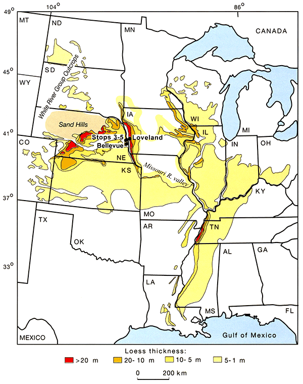
On this trip, we will visit loess localities in western Iowa and eastern Nebraska (fig. 1-1). The thick loess bordering the Missouri River valley has a long history of investigation dating back to the late 1800's. Recent studies at several localities have yielded new insights on several aspects of the region's loess and eolian record, most notably the chronology and sources of the loess. Some of the data in this guidebook are derived from previous studies reported in Bettis, Mason, et al. (2003), and some are presented here for the first time.
A detailed treatment of the trip area's Cenozoic stratigraphy is beyond the scope of this guidebook. Presented here are salient elements of the region's eolian stratigraphy that relate to localities visited on this trip. Extensive wind-deposited tuffaceous silts and sands with interbedded tuff occur in the wedge of Paleogene and Neogene sediment extending eastward from the Rocky Mountain Front Range across the western Great Plains. These sediments represent a range of eolian depositional environments that formed as sediment was shed from the rising Rocky Mountains via volcanic and fluvial processes during the Oligocene, Miocene, and Pliocene. Extensive sand sheets and thin loesses with associated paleosols occur in the Pliocene Fullerton Formation of Nebraska (Reed and Dreeszen, 1965; May et al., 1995) and its correlative, the upper part of the Blanco formation in Kansas (Frye and Leonard, 1952; Holliday, 1988). Yellowstone caldera-source Pearlette Family volcanic ashes provide three timelines for Great Plains stratigraphy: the late Pliocene (2.059 Ma--Huckleberry Ridge ash), early Pleistocene (1.285 Ma--Mesa Falls ash), and the middle Pleistocene (0.639 Ma--Lava Creek Bash) (Boellstorff, 1978; Izett and Wilcox. 1982; Lanphere et al., 2002). As yet poorly understood loess-paleosol sequences occur below the Lava Creek B ash in the Pleistocene Walnut Creek and Sappa formations of Nebraska and Kansas and above the Lava Creek B ash, but below Illinoian-age (marine oxygen isotope stage 6) Loveland Loess in the region (Reed and Dreeszen, 1965; May et al., 1995).
Four middle to late Pleistocene loess units occur in the eastern Plains. From oldest to youngest these are Loveland Loess, Gilman Canyon Formation (equivalent to Iowa's Pisgah Formation), Peoria Loess, and Bignell Loess. Loveland Loess is usually only a few meters thick (except near the Missouri River valley) and sometimes has an eolian sand facies. The last interglacial Sangamon Geosol is developed in the upper part of the Loveland. This paleosol is relatively thick (1.5-2.5 m), exhibits 7.5YR hue colors, and often contains clay coatings in the upper B horizon and carbonate coatings or nodules in the lower part of its profile. The Gilman Canyon Formation is also thin (usually <2 m) and usually modified throughout by organic accumulation and biological structures (burrows, etc.). The soil developed in the Gilman Canyon Formation (equivalent to the Farmdale Geosol east of the Missouri River valley) is usually welded to the underlying Sangamon Geosol developed in the Loveland Loess. In rare sections where the Gilman Canyon Formation is thick, two or more soils are developed in the unit. Peoria Loess buries the Gilman Canyon Formation. The Peoria is the thickest (up to 50 m) and one of the most aerially extensive last glacial loess deposits in the world (Muhs and Bettis, 2003). At some near-source localities eolian sand is interstratified with the loess and bedding structures are present. On stable upland summits in the western Great Plains of Nebraska and Kansas, the Bignell Loess buries Peoria Loess and the dark-colored Brady Soil is developed in the upper part of the Peoria. The Bignell is patchy in its distribution and appears not to occur as a once-continuous sheet as most of the other loess units in the region do. The Bignell is not present (or at least not discernable) in eastern Nebraska or anywhere east of the Missouri River valley, where the modem soil is developed in Peoria Loess.
Recent applications of luminescence dating to loess in the region are refining the region's loess chronology and have revealed the age structure of individual loess units at several localities. Thermoluminescence (TL) ages from Eustis in south-central Nebraska and TL and infrared stimulated luminescence (IRSL) ages from the Loveland paratype locality in western Iowa (Stop 2 on this trip) suggest that the Loveland Loess accumulated during the penultimate glacial period, equivalent to marine oxygen isotope stage 6 (Forman et al., 1992; Maat and Johnson. 1996; Forman and Pierson, 2002). Luminescence and radiocarbon ages on soil organic matter and charcoal bracket accumulation of the overlying Gilman Canyon Formation and its Iowa equivalent. the Pisgah Formation, to between ~45,000 and 25,000 cal yr B.P. (Forman et al., 1992; Martin. 1993; May and Holen. 1993; Pye et al., 1995; Maat and Johnson. 1996; Muhs et al., 1999; Forman and Pierson. 2002; Bettis. Muhs, et al., 2003). Thus, in the eastern and central Great Plains. the Sangamon paleogeomorphic surface, marked by the Sangamon Geosol, may have developed over a time span that corresponds to all of oxygen isotope stages 5 and 4. A large body of radiocarbon and luminescence ages--TL. IRSL, and optically stimulated luminescence (OSL)--indicates that Peoria Loess began to accumulate near its source areas around 23 ka and continued to accumulate across the region until about 12 ka (Muhs et al., 1999; Forman and Pierson. 2002; Roberts et al., 2003; Bettis. Muhs, et al., 2003). These ages indicate that Peoria Loess accumulated during the late Wisconsin glacial period (oxygen isotope stage 2). Suites of OSL ages through the Peoria at several sections demonstrate that the rate of accumulation varied through time in a systematic fashion across the region (see stops 2-4 on this trip and Roberts et al., 2003).
Maximum limiting ages of the Bignell Loess are based on radiocarbon ages of soil organic matter from the Brady Soil developed in the upper part of the Peoria Loess. These ages in combination with other radiocarbon and luminescence ages within the Bignell Loess indicate that the unit accumulated episodically through the entire Holocene (Martin. 1993; Pye et al., 1995; Maat and Johnson. 1996; Muhs et al., 1999; Mason and Kuzila. 2000; Mason. Jacobs. Hanson, et al., 2003).
Studies of provenance tracers (zircon ages, Pb isotopes in K-feldspar, and loess geochemistry) as well as thickness trends have demonstrated that the Peoria Loess is derived from several sources, some glaciogenic in origin and others nonglaciogenic (Aleinikoff et al., 1999: Muhs and Bettis. 2000; Mason, 2001; Bettis, Muhs, et al., 2003). Eocene and Oligocene volcaniclastic siltstones of the White River Group (and possibly the Arikaree Group) were a significant nonglaciogenic source of the Peoria Loess. while the Platte and Missouri River valleys were the major glaciogenic sources. Although large dune fields, such as the Nebraska Sand Hills. were the area of last entrainment for much of the loess in Nebraska, Pb isotopic composition and the ages of zircons in the loess indicate that most of the silt was ultimately derived from bedrock sources. Nevertheless. eolian sand was an essential component of the regional loess sedimentary system as it served as the tool in ballistic impacts that brought silt and clay particles into suspension in the atmosphere.
Thickness patterns and grain-size and geochemical trends indicate loess- and sand-transporting winds were dominantly from the northwest or west across the region (Smith, 1942; Hutton, 1947; Snowden and Priddy, 1968; Ruhe, 1983; Mason et al., 1994; Muhs et al., 1999; Muhs and Bettis, 2000; Mason, 2001). On this trip we will examine thick deposits of last glacial loess that are located immediately downwind (east) and upwind (west) of the Missouri and Platte River valleys. As we will see, not all of the loess in these sections was derived from these valley sources.
This locality is approximately 7 km north of the Platte River valley and about 5.5 km west of the Missouri River valley (fig. 1-1). Last-glacial loesses, the Sangamon Geosol developed in Loveland Loess, and a sequence of older loesses and paleosols are present here (fig. 1-2a). Peoria Loess is thicker at localities like Bellevue, along the east side of the Missouri River valley, than to the immediate west (Mason, 2001; Bettis, Muhs, et al., 2003). Mason (2001) estimated that the Missouri and Platte valleys may have contributed from 25% to no more than 50% of the loess deposited at localities in eastern Nebraska (this issue is discussed in more detail at Stop 3). Missouri River valley-source loess west of the valley in Nebraska indicates that although loess-transporting winds were primarily westerlies, easterly or northeasterly winds did at times carry significant quantities of dust (Mason, 2001).
Figure 1-2--Loess stratigraphy (A) and geochemistry (B) at the Mass Drive site south of Omaha, Nebraska. Note that the Peoria Loess here is finer-grained than Missouri River source loess at Loveland (Fe2O3 content is a proxy for clay content) and that the Ti/Nb ratio, a provenance indicator, is intermediate between Missouri River source and western source loess. The K2O/TiO2 and CaO/TiO2 ratios show the greatest degree of weathering in the Sangamon Geosol and a lesser degree of weathering in the Gilman Canyon Formation and the modem soil. Geochemistry determined by energy dispersive X-ray fluorescence.
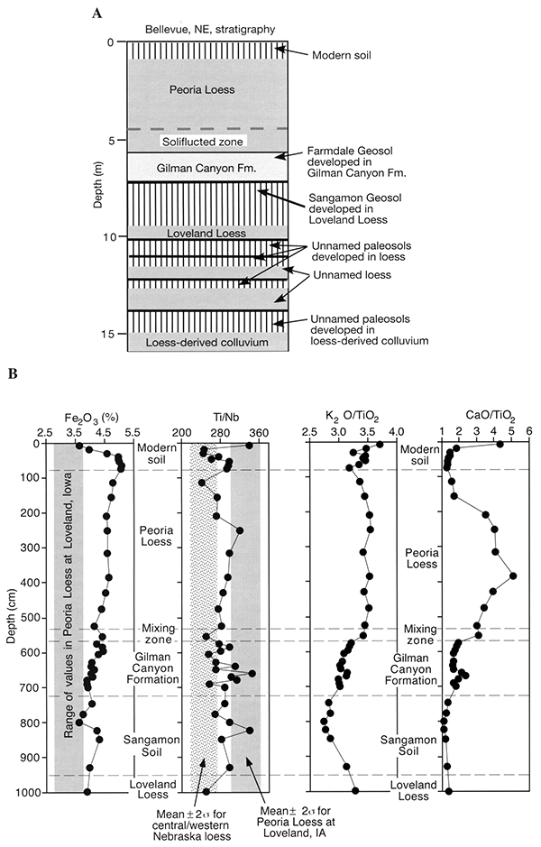
The geochemistry of the loesses and soils in the section provide information pertinent to potential loess sources and post-depositional weathering (fig. 1-2b). Bulk Fe2O3 (i.e., ALL Fe) is correlated highly with clay content because of the smectite-dominated clays in loess for this part of the continent (Muhs and Bettis, 2000; Muhs et al., 2001). The higher clay content in the Bt horizon of the modern soil stands out, and the Peoria Loess has greater clay content here than Peoria Loess at Loveland (Stop 2). Because Bellevue is close to the Missouri River, one might expect a clay content that is relatively low, as at Loveland. The higher clay content, reflected in bulk Fe2O3 suggests a mix of sources from both the nearby Missouri River and more distal sources to the west (this will be discussed further at stops 2 and 3).
Titanium (Ti) and niobium (Nb) are elements found in resistant, detrital minerals such as ilmenite (basic igneous rocks), rutile (igneous/metamorphic rocks), anatase (metamorphic rocks), and titanomagnetite (igneous/ metamorphic rocks). As such, the Ti/Nb ratio changes little or not at all even with considerable chemical weathering and is therefore a useful provenance indicator. Ti/Nb values in Peoria Loess at Bellevue show values that are intermediate between the values found in Peoria Loess at Loveland. Iowa (Missouri-dominated source), and Peoria Loess found in central and western Nebraska (western source). Thus, we interpret Peoria Loess at Bellevue to be derived from a combination of an immediate, eastern source (the Missouri River) and the distal facies of loess found in central and western Nebraska. If this interpretation is correct. it explains why Peoria Loess at Bellevue has somewhat higher clay contents (represented by Fe2O3) than at Loveland.
Potassium (K) is found mostly in two common loess minerals. K-feldspar (microcline and orthoclase) and mica (biotite, muscovite. and illite). K-feldspar and muscovite are relatively resistant to chemical weathering (although not invulnerable!), so K2O losses, relative to immobile TiO2, probably reflect chemical weathering of biotite and illite. Note that zones within the modern soil are depleted in K2O relative to underlying unweathered Peoria Loess. The Gilman Canyon Formation, which consists mostly of pedogenically altered loess, also has significant K2O loss. However, the greatest loss is evident in the Sangamon Soil. The greater degree of chemical weathering in the Sangamon Soil compared to either the Gilman Canyon Formation (Farmdale Soil) or the modern soil is consistent with its better-expressed morphology and greater thickness. Is the greater chemical weathering and degree of soil development in the Sangamon Soil (compared to the modern soil) due to a more humid and perhaps warmer paleoclimate or a longer period of pedogenesis (e.g., all of the equivalent of marine isotope stage 5, not just substage 5e) or both? Ruhe (1969) struggled with this question for Sangamon Soils in adjacent Iowa and thought it most likely that both paleoclimate and time were factors.
The ratio CaO/TiO2 provides another chemical weathering index. This ratio is a proxy for the degree of carbonate mineral (calcite and dolomite) depletion. Note that the ratio is high in the modern soil A horizon (as with K2O/TiO2), which is probably a function of biocycling. Deeper in the modern soil profile, however, carbonates are absent. Even in the upper part of Peoria Loess. carbonate content is low, suggesting that loess-deposition rates were low during the final phases of sedimentation. Between 3 and 4 m depth, the CaO/TiO2 value is relatively high, suggesting rapid loess deposition with little syndepositional leaching of carbonates. The lower part of the Peoria Loess appears to be lower in carbonate content but not as low as during the waning stages of loess deposition. Few or no carbonates are present in the Gilman Canyon Formation, suggesting low rates of loess sedimentation and/or a relatively humid paleoclimate. As with K2O/TiO2 values. however, the greatest degree of carbonate depletion is found in the Sangamon Soil. Carbonates are depleted significantly throughout this thick paleosol, supporting the interpretations of a humid last-interglacial paleoclimate, a long period of pedogenesis (perhaps all of marine isotope stage 5), or both.
The lowest 1-1.5 m of the Peoria is distinctly different from the loess above it. This basal zone has more mottles. contains streaks of deoxidized (light-gray) silt and secondary accumulations of manganese oxide. exhibits coarse horizontal parting, and has prominent wavy "streaks" of organic-rich silt (including charcoal) that are sometimes overturned into recumbent folds. AMS radiocarbon ages on humic acids extracted from organic matter in three of the organic-rich zones yielded ages of 22,040±160 14C yrs B.P. (CAMS-10181; 32 cm above base of Peoria), 20,810±160 14C yrs B.P. (CAMS-10187; 36 cm above base of Peoria), and 22,210±170 14C yrs B.P. (CAMS-10188; 38 cm above base of Peoria). These ages are out of stratigraphic sequence and older than would be expected from the base of the Peoria Loess. This can be explained by considering the genesis of the basal part of the Peoria. Several investigators have noted features attributable to periglacial activity in the upper midcontinent (Péwé, 1983; Muhs and Bettis, 2003), and paleoecological studies point to the period from about 21.000 to 16,500 14C yr B.P. as one that brought arctic fauna and flora into Iowa, Illinois, and eastern Nebraska (Baker et al., 1986; Schwert et al., 1997). The wavy topography and discontinuous nature of the organic-rich beds and the presence of overturned folds and horizontal partings in the basal Peoria sediments suggest that solifluction played a role in the accumulation of this zone. If the basal zone contains sediment deposited by solifluction during the initial phase of Peoria Loess accumulation, then the organic-rich zones were probably derived from the A horizons of the surface soil (Farmdale Geosol) upslope. The radiocarbon ages, therefore, may not date the time of deposition, but rather the age (mean residence time) of carbon in the soil being eroded upslope.
The Peoria abruptly overlies the Farmdale Geosol developed in the Gilman Canyon Formation (fig. 1-2A). Lithologic characteristics of the Gilman Canyon Formation here are very similar to the Pisgah Formation across the river in Iowa. The unit is modified by the Farmdale Geosol which lacks the strong biofabric common to the Gilman Canyon pedocomplex at many sites across Nebraska. Charcoal collected 10 cm below the top of the Gilman Canyon Formation at this section yielded an AMS radiocarbon age of 25,340±260 14C yrs B.P. (CAMS-10190).
The Gilman Canyon Formation has a gradational boundary with the underlying Sangamon Geosol developed in Loveland Loess. Here the Sangamon is a morphologically well-expressed soil with a 2-m-thick A-AB-Bt profile, thick continuous clay films. strong structure, and strong rubifaction. The base of the Sangamon Geosol is not exposed, but a hand boring below the exposed section indicates that a sequence of older silts (loess) and paleosols are present beneath the Loveland (fig. 1-2A). The ages of these units are presently unknown, but they probably correlate with the "silty clays" discussed at Stop 3.
The motel (Interstate Inn, Council Bluffs, Iowa) is located on a historic Missouri River channel belt (Hallberg et al., 1979). The alluvial fill of the Missouri River valley ranges from 25 to about 40 m in thickness in this area (Miller, 1964; Iowa Geological Survey file data) and consists of a thin veneer of fines (2-5 m) grading downward to medium to coarse sand with a few-meter-thick basal gravel. Near the bluff line the stratigraphy becomes much more complex as wedges of tributary alluvium and slope deposits interfinger with the main valley sediments. The valley floor east of the present river is Holocene in age, but on the west side of the river Wisconsin interstadial floodplain deposits (ca. 25.5-23 ka) are preserved beneath the Peoria Loess-mantled Fort Calhoun Terrace. In the Omaha/Council Bluffs area, the bedrock surface (Pennsylvanian) is deepest on the east side of the Missouri River valley and rises in a series of steps westward. The bedrock surface beneath the Fort Calhoun Terrace is higher in elevation than the base of the modern Missouri River channel. Several large quarries in the area extract Pennsylvanian limestone, primarily for use as aggregate.
This area was last glaciated during the pre-Illinoian, about 500 ka. Multiple glaciations, beginning about 2 Ma, affected the central North American midcontinent and deposited a series of matrix-supported glacial diamictons (Boellstortf, 1978; Roy et al., 2004). It was probably during the last one or two of these glaciations that the Missouri River valley evolved into its present position and major tributary configuration (Wayne, 1985); loess stratigraphy discussed at Stop 3 may ultimately shed more light on this issue.
During the last glacial period, the Missouri River valley drained the western margin of the Laurentide ice sheet and also was fed by rivers draining unglaciated parts of the central and northern Great Plains. The Platte River, which carried outwash from Rocky Mountain Front Range glaciers and also drained a large portion of the unglaciated central Great Plains, joins the Missouri just south of Omaha.
Bluffs along both sides of the valley are mantled with loess. Pre-Illinoian glacial diamicton generally crops out low along the bluff and is overlain by up to 50 m of late Pleistocene loess.
The three most widespread loess units in the North American midcontinent (Peoria, Gilman Canyon/Pisgah, and Loveland) are present at the Loveland section in western Iowa (figs. 1-1 and 1-3). Glacial till deposited during the later part of the Matuyama Chron, ca. 1.2-0.8 Ma ("A" till of Boellstorff, 1978; R1 till of Roy et al., 2004) underlies the loess sequence here.
Figure 1-3--Stratigraphy and radiocarbon and luminescence chronology of the Loveland locality in western Iowa.
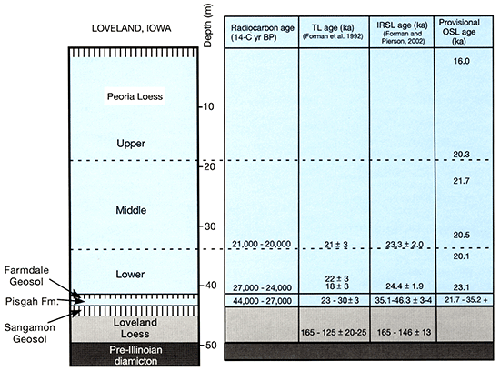
This is the reference locality (paratype) for the Loveland Loess, which dates from the penultimate ("Illinoian") glaciation. Thermoluminescence (TL) and infrared stimulated luminescence (IRSL) age estimates from the Loveland here range from 165 to 125 ka, and are in good agreement with TL ages of Loveland Loess from Nebraska (Maat and Johnson, 1996; Forman et al., 1992; Forman and Pierson, 2002). The Sangamon Geosol is developed in the upper part of the Loveland Loess and represents weathering, soil development, and landscape evolution that occurred through the last interglacial and until the overlying Pisgah Formation loess began to accumulate. Charcoal 3 cm above the base of the Pisgah Formation dates 42,150±2,350 14C yrs B.P. (CAMS-6359) and 44,790±3,250 14C yrs B.P. (CAMS-6638) at this section. Luminescence ages (TL, IRSL, and OSL) are in general agreement and bracket accumulation of the Pisgah Formation between about 46 and 23 ka. Carbonate nodules collected from the Loveland Loess 5.5-6.5 m below the top of the Sangamon Geosol give U-series ages ranging from 57,000±6,000 to 68,000±8,000 yrs (table 1-1), suggesting that they formed during the latter part of marine oxygen isotope stage 4 and at the stage 4/3 boundary, rather than during stage 5 (the last interglacial). Carbon isotopic data from speleothems in Crevice Cave, near St. Louis, Missouri, indicates that the interval during which these carbonate nodules formed was one of general warming in the midcontinent that culminated between 55 and 59 ka (Dorale et al., 1998). At Loveland. the Sangamon paleogeomorphic surface, marked by the Sangamon Geosol marks a ca. 80,000-year-long depositional hiatus spanning the last interglacial period and most of the early and middle Wisconsin (oxygen isotope stages 5, 4 and the first half of 3).
The Sangamon Geosol at this locality (solum thickness <2 m, weak to moderate grade soil structure, and no clay coatings) has a much more weakly expressed morphology than the Sangamon we observed at Stop 1. The first impression is that the level of morphologic expression at Loveland is inconsistent with an extended period of weathering covering a full interglacial period. One needs to keep in mind, however, that this is a "bluff line" locality and that local relief on the Sangamon paleogeomorphic surface probably inhibited soil horizonation through runoff, surficial erosion, and reduced infiltration. A short distance east of the bluff line where upland divides are wider, the Sangamon Geosol has thick, well-expressed soil horizons with strong structure and abundant clay coatings, very similar to that observed at Stop 1. Similar patterns in soil development are seen in transects of modern soils extending from the bluff line eastward.
At Loveland, Pisgah Formation loess accumulated between about 46 and 23 ka (fig. 1-3) as the first Wisconsin advance of the Laurentide ice sheet into the midcontinent occurred (Bettis et al., 1996; Curry, 1998; Dorale et al., 1998). The Pisgah (stratigraphically equivalent to the Gilman Canyon Formation in Nebraska) here is exceptionally thick (4 m) and is one of the few examples of relatively unaltered isotope stage 3 loess in the region. Small pieces of Picea charcoal and land snails within the unit, as well as rare pollen records, indicate that this loess accumulated on a landscape occupied by vegetation communities that probably shifted from parkland to boreal forest (Baker et al., 1991; Baker et al., 2003). The Farmdale Geosol is developed in the upper 50-60 cm of the Pisgah Formation. This soil marks a significant interstadial period of very slow or no loess accumulation. Abundant pollen and macrofossil evidence indicate that the western Iowa landscape was occupied by boreal forest as this soil formed. As we saw at Stop 1, the Farmdale Geosol is often partially eroded and/or deformed, and at Loveland the Farmdale is a 50-60-cm-thick AC soil profile that is discontinuously present across the section.
During the last decade this section has been the focus of several investigations addressing the chronology, sedimentology, and geochemistry of Missouri Valley-source Peoria Loess. About 41 m of Peoria Loess occurs above the Farmdale Geosol at Loveland. The Peoria is a massive, pale-brown to light-yellowish-brown, calcareous silt loam that extends to the modern land surface. A large number of radiocarbon ages from across the region suggest that Peoria Loess began to accumulate between 23,000 and 18,000 14C yrs B.P. (Bettis, Muhs, et al., 2003). When the Peoria Loess stopped accumulating is unknown, but estimates based on a few radiocarbon ages of gastropod shells and soil organic matter range from 11,000 to 12,000 14C yrs B.P. (Wang et al., 2000; Bettis, Muhs, et al., 2003).
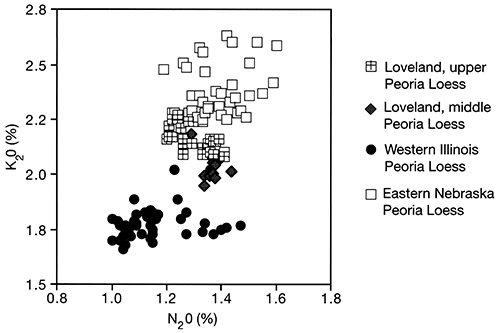
Grain-size and geochemical analyses demonstrate that Peoria Loess is not uniform in composition through the section (Muhs and Bettis, 2000). Three grain-size zones are present, an upper finer-grained zone, a coarser middle zone, and a lower zone where grain size is more variable (fig. 1-4). The upper and middle zones also differ geochemically. Muhs and Bettis (2000) showed that Peoria Loess at Loveland has geochemical properties intermediate between nonglaciogenic loess of Nebraska and glaciogenic loess of western Illinois. Eastern Nebraska loess has higher K2O content (from K-feldspar and micas) and generally higher Na2O content (plagioclase) than western Illinois, differences that reflect different silicate mineralogy in the source rocks of these loesses (fig. 1-5). Overall, the Peoria at Loveland is intermediate in composition between Nebraska and Illinois loess. indicating that it could contain a mixture of both Laurentide-derived source sediments (glaciogenic) and nonglaciogenic source sediments. The composition of the upper grain-size zone of the Peoria Loess at Loveland is more like that of nonglaciogenic (eastern Nebraska) loess, while the middle zone's composition is more like the glaciogenic loess of western Illinois. This suggests that there may be a larger component of nonglaciogenic, Nebraska-type source loess in upper Peoria Loess than in middle Peoria Loess at Loveland.
Figure 1-4--Grain-size and silica/carbonate depth plots for the loess sequence at the Loveland site. Note the presence of three distinct grain-size zones in the Peoria Loess: upper fine-grained zone, a coarser middle zone, and a lower zone of variable grain size. The silica/carbonate plot indicates that the lower zone is depleted in carbonate relative to the upper zones. Grain-size analysis was done using the pipette method; chemistry was done by wavelength-dispersive X-ray fluorescence. Data from Muhs and Bettis (2000).
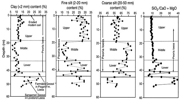
Figure 1-5--Concentrations of K2O and Na2O in bulk samples of upper and middle Peoria Loess at Loveland, Peoria Loess in eastern Nebraska (Plattsmouth, Elba, and Lincoln sections), and Peoria Loess in western Illinois (Morrison and Rapids City B sections). The plot shows that upper Peoria Loess has geochemical properties similar to those of nonglaciogenic eastern Nebraska loess, while the geochemistry of the middle Peoria Loess at Loveland is more like glaciogenic (Laurentide-source) loess of Illinois. Adapted from Muhs and Bettis (2000).
A series of OSL ages, determined using a modified single aliquot (SAR) procedure on 30-50-µm quartz, reveals the age structure of the Peoria Loess at Loveland (fig. 1-3). The lower 7 m of the Peoria accumulated between about 23 and 20 ka, slow enough that carbonate was partially leached from this zone as the loess accumulated (fig. 1-4; Muhs and Bettis, 2000). Ages from the middle increment of the Peoria (-33-19 m) are statistically indistinguishable, agreeing to within 1 sigma error. The change from the middle to upper zone of the Peoria Loess (at 19-m depth) occurred abruptly about 20 ka. and the upper Peoria accumulated over a 4,000-yr period until about 16 ka (fig. 1-3). Mass accumulation rates (MAR) calculated based on the central values for the OSL ages and assuming a typical loess bulk density of 1.45 g cm-2show that, based on the uppermost and lowest OSL ages alone, the average mass accumulation rate over the last glacial period is extremely high at ~8,169 g m-2yr-1. This value is one to two orders of magnitude higher than those calculated for last glacial eolian silt elsewhere in the world (Roberts et al., 2003). At Loveland, MAR varies from 3,383 g m-2yr-1 in the lower Peoria to 6,070 g m-2yr-1 in the upper Peoria. In the middle zone of the Peoria loess. accumulation was more rapid than OSL dating allows us to resolve (>10.000 g m-2yr-1).
Table 1-1--Uranium-series isochron-plot ages of carbonate nodules from the Loveland Loess at Loveland, western Iowa. U-series ages were calculated from half-lives 230Th and 234U of 75,200 and 244,000 years, respectively; errors of ages are reported at 1 standard deviation. Ages were determined by B. Szabo, U.S. Geological Survey (retired).
| Sample | Age, ka |
|---|---|
| LN-2 | 63±6 |
| LN-52 | 68±8 |
| LN-62 | 57±6 |
We drive along the base of the eastern bluff of the Missouri River valley for the next approximately 30 km (18.5 mi). The stratigraphic sequence beneath this bluff line is similar to that which we observed at the last stop. We cross the Boyer River about 4 km north of Stop 2. This river carried outwash from the Des Moines Lobe of the Laurentide ice sheet from about 18-16.5 ka. The late glacial floodplain is 10-15 m below the level of the modern floodplain but rises above it approximately 12 km up the valley. Steeper-than-modern last-glacial gradients are typical of valleys that drained the Laurentide ice sheet. The Missouri River valley widens as we proceed north, and the depth to bedrock increases. This is a region of classic "loess topography" produced by a combination of a thick loess mantle and deeply entrenched stream systems. Shimek (1896, 1898) proposed the eolian origin for loess on the basis of the occurrence of terrestrial gastropod fauna in the loess and the distribution of the loess across the highest parts of the landscape in this region.
At this stop we will discuss loess stratigraphy in the Omaha area, based mainly on cores and other subsurface data.
Despite the long history of loess research in the middle Missouri River valley and adjacent regions at the eastern edge of the Great Plains, little of that work has focused on the west side of the valley near Omaha, Nebraska. The east side of the Missouri Valley in southwestern Iowa has attracted more attention in part because of the many well-exposed loess sections there, but also because of the influence of the geomorphic and stratigraphic research programs directed by Robert Ruhe in the 1960's (Ruhe, 1969; Ruhe and Cady, 1967; Ruhe et al., 1971). Furthermore. the middle Missouri Valley is generally interpreted as a classic glaciofluvial loess source; by analogy with other glaciofluvial sources such as the Mississippi River valley, the thickest and most complete loess sections should be on the east side.
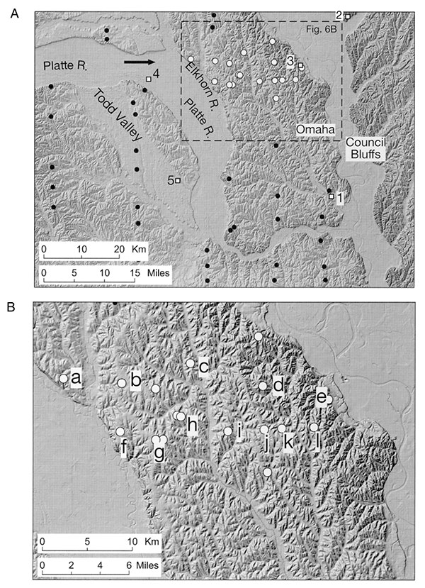
Recent research suggests that the stratigraphic record of loess deposition in eastern Nebraska deserves much more attention, because of the information it may provide on loess sources and their climatic and glacial controls during the middle and late Pleistocene. Eastern Nebraska potentially received significant amounts of dust influx from several very different loess systems, during late Pleistocene deposition of Peoria Loess, and possibly during deposition of older units (Mason, 2001; Muhs and Bettis. 2000). The nearby Missouri Valley is the most obvious loess source near Omaha, and thickness trends (discussed in more detail below) confirm its local importance (Mason, 2001). However, as discussed at earlier stops, there is evidence that Peoria Loess from nonglacial sources on the Great Plains was transported as least as far eastward as the Missouri Valley (Muhs and Bettis, 2000). Finally. there is some evidence that the Platte and Elkhorn river floodplains were secondary Peoria Loess sources in Nebraska. though only detectable within 40 km of the Platte or Elkhorn valleys (Mason, 2001 ). The lower Platte and Elkhorn rivers share a wide valley within 40 km of many of the new loess sections that have been cored in the Omaha area (fig. 1-6), and thickness trends in those cores support earlier suggestions that the Platte Valley was a locally significant loess source.
Figure 1-6--Shaded relief images of the Omaha area. (A) Regional view, showing field-trip stops, study sites, and the Todd Valley. Arrow indicates new path taken by the Platte when it was captured by an Elkhorn River tributary, causing abandonment of the Todd Valley. Stops on this field trip indicated by numbered squares (exact locations subject to change in some cases). Unfilled circles indicate locations of cores and mud-rotary test holes used to characterize loess stratigraphy north of Omaha. Smaller filled circles are other sites drilled by the Conservation and Survey Division that are in landscape positions suitable for characterizing loess stratigraphy (mainly upland summits). (B) Area north of Omaha where loess stratigraphy is best known because of recent drilling associated with geologic mapping projects. Unfilled circles are loess study sites, as in A. Sites used in constructing the fence diagrams in fig. 8 are labeled with lower-case letters.
The three possible sources of Peoria Loess near Omaha could have had distinctly different controls, and loess transport from these sources may have begun, peaked. and ended at different times. For example, peak dust production from the Missouri River floodplain may have occurred when high glacial sediment input and highly variable meltwater discharge combined to produce abundant wind-erodible sediment on a broad un vegetated floodplain, analogous to glaciofluvial loess sources in Alaska today (e.g., Péwé, 1951). In contrast, Peoria Loess influx to the Omaha area from nonglacial Great Plains sources was almost certainly under the direct control of climatic and vegetation change within the source areas (Mason. 2001; Muhs et al., 1999). Dust production from the Platte River floodplain may have been influenced by glaciers in the Rocky Mountains. but that influence was always remote from the Omaha area. Floodplain conditions favoring dust production may have been more closely related to climatic change in the basins of the Loup and Elkhorn rivers, the Platte's major Great Plains tributaries.
Roberts et al. (2003) recently suggested that loess in the midcontinent is not simply a passive recorder of paleoclimate and/or ice sheet fluctuations but may have actively influenced climate in areas downwind of loess sources. This highlights the importance of sorting out the relative timing of loess influx from various sources to the Omaha area: that information is crucial to understanding the interplay of climate and ice-sheet dynamics in controlling the production of dust that was then carried eastward across the midcontinent. Work at the Loveland section (Stop 2) has already demonstrated distinct temporal changes in Peoria Loess properties consistent with changing provenance (Muhs and Bettis, 2000). A more detailed picture should be available through research on temporal and spatial trends in the abundance of multiple provenance tracers in Peoria Loess across eastern Nebraska, where "dust plumes" from these sources overlapped.
The cores we will see at this stop, and others like them, raise an even more intriguing question: Were older loess units also transported from the same mixture ofglacial and nonglacial sources as Peoria Loess? If so, then many of the insights gained from studying the climatic and glacial controls on these sources in the case of Peoria Loess may be applicable to older units as well.
Over the past five years, cores collected during geologic mapping projects have demonstrated that a rich stratigraphic record is preserved in thick loess of eastern Nebraska. These cores, mainly from the area north of Omaha between the Missouri and Elkhorn rivers (fig. 1-6). also illustrate the value of subsurface investigations on broad upland summits. There are many exposures of Peoria Loess in the Omaha area, in gullies, roadcuts, and borrow pits, but few are located on wide ridge tops and many do not expose the entire thickness of Peoria Loess. Many outcrops also expose the Gilman Canyon Formation and the uppermost Loveland Loess, but virtually all of these are on side slopes. During extensive field work in 1997-2002, we located only three exposures of preLoveland loess, one a large quarry face cut through a spur ridge descending to the Platte River valley, and the other two small roadcuts poorly exposing the loess section. Given previous work in the Midwest that demonstrated truncation of loess sections on hillslopes (Ruhe, 1967; Ruhe, 1969; Ruhe and Cady, 1967), we turned to subsurface data from broad upland summits to more adequately characterize loess stratigraphy.
Figure 1-7--Example of wireline geophysical logs from a mud rotary testhole in the Omaha area. Basis for log response and loess stratigraphic units are discussed in the text. Test hole 9-A-98 was drilled in a roadcut and the zero point on the depth scale is actually 3 m below the natural land surface. Core 1O-B-98 (fig. 1-8) was collected on a nearby summit and has similar loess stratigraphy.
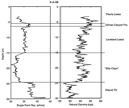
Prior to 1997, the major source of information on loess stratigraphy in the Omaha area was a large number of geologic test holes drilled by the Conservation and Survey Division (Nebraska's state geological survey) from the 1930's to the 1980's. Two north-south lines of test holes, 19 km apart, were drilled in the Omaha area between the Missouri and Elkhorn rivers (fig. 1-6A). Test holes were drilled at approximately 5-km intervals along each line, with the exact drilling locations placed on ridgetops where possible. The test holes were drilled using mud-rotary methods, usually to the base of the Cenozoic. Stratigraphy was inferred from drill cuttings carried to the surface in drilling mud, together with changes in drilling action and geophysical wireline logs (examples are shown in fig. 1-7). A pause in drilling was used to clean the mud of old cuttings, at each major change in lithology and every 1.2 m when lithology was uniform; this greatly enhances the accuracy of stratigraphic boundary placement. Geophysical logs typically included single point resistance (SPR) and spontaneous potential (SP) measurements. Higher values of SPR correspond to coarser grain size and/or lower water content. Some fine-grained sediments with strong pedogenic structure also have high SPR values, perhaps because large pores between peds have an effect similar to large intergranular pores in unstructured sediment. The SP log (not shown in fig. 1-7) is generally the inverse of the SPR log.
Between 1997 and 2001, eight additional mud-rotary test holes were drilled and 15 hollow-stem auger cores were collected in the Omaha area. Most of the new drilling was for the purposes of surficial geologic mapping, with one core collected for an NSF-funded project on loess chronology. The cores were collected mainly on ridge summits. with a few on lower slopes. The new mud-rotary test holes were located on summits, side slopes, or foot slopes. and were drilled by methods similar to those used in earlier years, except that natural gamma logs were collected along with SPR data (fig. 1-7). Natural gamma logs have high values in sediment that contains abundant K, U, and Th, usually because of high clay content. The 5-cm-diameter hollow-stem auger cores were collected continuously to depths of up to 33 m. Core recovery was often near 100% in the loess section, except for two stratigraphic intervals. The middle and lower Peoria Loess often collapsed and jammed the coring tube, leading to poor recovery. The strongly structured upper part of the Sangamon Geosol also jammed and was not fully recovered at some sites. Loess stratigraphy interpreted from cores and test holes in the Omaha area can be compared with abundant subsurface data from elsewhere in eastern Nebraska. This includes many pre-1997 mud-rotary test holes and several auger cores collected in 1998-2002.
Optically stimulated luminescence (OSL) dating is in progress on core samples from one site north of Omaha (Stevens Site, same locality as Core 1-B-98 in fig. 1-8; locality k in fig. 1-6B). From the same core, samples have been analyzed to determine content of meteoric 10Be (10Be formed in the atmosphere and deposited with precipitation), to extend the chronology beyond the current limits of luminescence dating. Another core (3-B-99 in fig. 1-8; locality c in fig. 1-6B) has been used by Greg Balco and John Stone (University of Washington) in testing a new method of dating sediment burial using the content of 10Be and 26Al produced in situ. Minimally disturbed samples from several cores have been used to prepare thin sections, mainly for characterizing the paleopedology of the loess section. Grain-size analysis and X-ray diffraction analysis of clay mineralogy have been carried out on samples from several cores and one outcrop.
On the relatively stable parts of the landscape represented by these cores. a regionally coherent record of loess deposition and soil formation is preserved (fig. 1-8). This record is apparently more complete and may represent a longer period of time than the loess sequences previously described at exposures east or west of the Missouri River. Cores and test holes on broad upland summits north of Omaha consistently contain the same sequence of depositional units. The oldest sediments in this sequence, informally designated the "silty clays." may correlate in part with poorly understood pre-Loveland loess units that are extensive on the Great Plains (e.g., Feng et al., 1994) and are occasionally observed in the Mississippi Valley (e.g., Jacobs and Knox, 1994; Markewich et al., 1998). The three units above the silty clays can readily be correlated with formal lithostratigraphic units established for loess across the midcontinent: from oldest to youngest, these are the Loveland Loess, Gilman Canyon Formation (stratigraphically equivalent to the Pisgah Formation in Iowa and the Roxana Silt in Illinois and Wisconsin), and Peoria Loess.
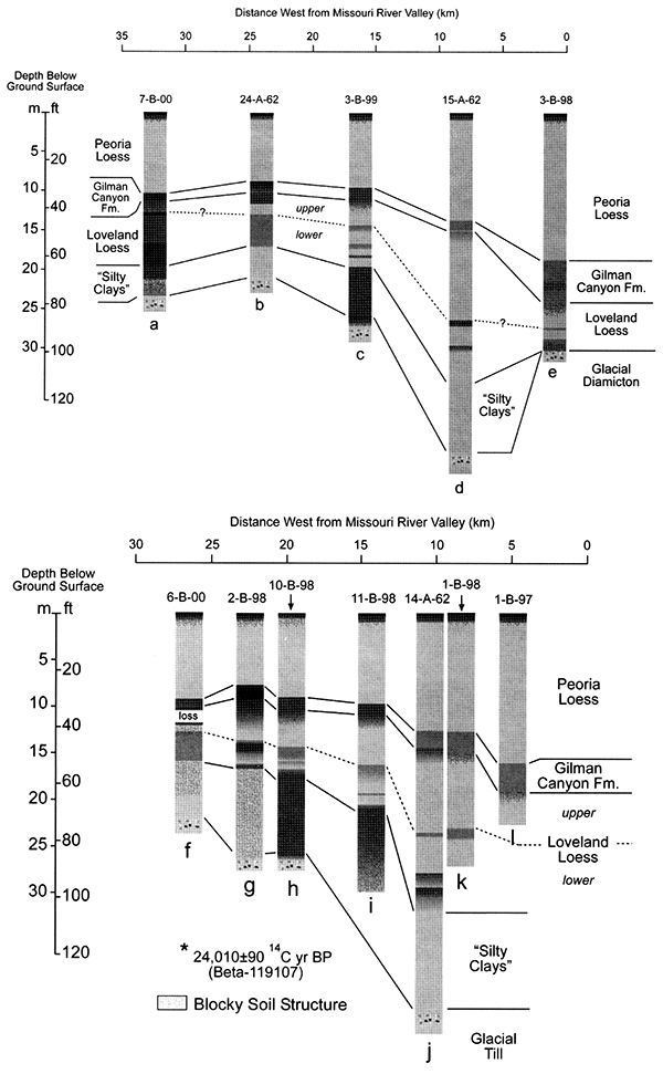
Figure 1-8--Loess stratigraphy along two approximately west-east transects north of Omaha (site locations keyed to fig. 1-6B). Gray shades represent lighter and darker colors (i.e., Munsell values), and the occurrence of strongly expressed blocky structure in cores is also indicated.
Outcrops, test holes, and cores on hillslopes provide an important additional insight on loess stratigraphy in this area. All units observed in the loess sequence on summits are truncated to varying degrees on steep backslopes, and in some cases glacial till is at the surface. However, the entire sequence (including the silty clays) is present on some upper footslopes and low spur ridges, although each unit is thinner than on adjacent summits. The occurrence of all of the units in the sequence both on ridge tops and much lower in the landscape strongly supports the interpretation that all are primarily loess, rather than lacustrine or depression-fill sediment. This distribution also indicates that the present stream-dissected topography was at least partially developed before the end of deposition of the silty clays, and well before the last glaciation. In effect, each loess unit has draped a pre-existing landscape of ridges and valleys but has been preserved to varying degrees depending on the local slope gradient.
The "silty clays" have a total thickness of 6-9 m on wide ridge tops and rest directly on the uppermost glacial diamicton (except in one outcrop described below). Where encountered in older test holes, the silty clays were often labeled "Sappa Formation," but no clear correlation to the type-Sappa section in south-central Nebraska (Reed and Dreeszen, 1965) can be established. The "Yarmouth Clay." described in southwestern Iowa by Ruhe and Cady (1967), was interpreted by those authors as a lacustrine deposit, but could correlate with part or all of the silty clays near Omaha. The stratigraphic position of the silty clays indicates that they post-date the most recent pre-Illinoian glaciation of the Omaha area. Boellstortf (1978) reported no glacial deposits overlying the Lava Creek Bash (640 ka) in eastern Nebraska, although they exist in Iowa and South Dakota. At a quarry south of Omaha, the silty clays rest on fine-grained laminated sediment, probably lacustrine, that overlies Pennsylvanian bedrock. An undated volcanic ash is interbedded with this lacustrine sediment. This ash is most likely the Lava Creek B, which is present at many more localities than any other tephras in eastern Nebraska and Iowa. Thus, the silty clays may have begun accumulating shortly after 640 ka, although much more geochronological work on this unit is clearly needed. if this inferred basal age is correct, and the loess sequence does not contain large unrecognized unconformities, the silty clays represent several glacial-interglacial cycles represented by marine isotope stages.
The texture of the silty clays is variable within a single section, typically ranging from clay or silty clay to silty clay loam. High-resolution particle-size analysis by laser diffraction indicates a prominent medium-coarse silt peak (characteristic of loess), with a shoulder or secondary peak in the clay to fine-silt range. Geophysical logs run in mud-rotary test holes indicate that the silty clays have very low resistivity and emit relatively high natural gamma radiation, both indicative of high clay content (fig. 1-7). Gamma logs suggest multiple distinct peaks of clay content (fig. 1-7), but insufficient particle-size data are available to test for such peaks in the cores. Weak to strong pedogenic blocky structure is present throughout much of the thickness of the silty clays, with hints of granular structure in some horizons. However, discrete A-B-C soil profiles are rarely identifiable, except at the base of the unit, where a soil is developed through a gradational contact with underlying diamicton. Root traces and clay coatings on ped faces are often present. Thin sections confirm the presence of illuvial clay coatings in some cases, but also indicate strong stress orientation of clay, probably the result of shrink-swell cycles.
The silty clays are interpreted as a stack of several thin depositional units, primarily loess, but also possibly including some depression-fill or pond sediment toward the base. The lowermost meter of the silty clays often contains scattered coarse sand grains and pebbles; these could have been mixed upward by bio- or cryoturbation, but would also be consistent with a depression-fill origin. This stack of sediment was strongly overprinted by pedogenesis as it accumulated, resulting in such effective welding of overlapping soil profiles that they are no longer recognizable. In effect, the original B horizon in the soil, formed at the basal contact of the silty clays, has grown upward through the rest of the unit because of its slow average rate of deposition.
Loveland Loess north of Omaha is clearly correlative with the same unit at its paratype section immediately across the Missouri in Iowa (Bettis, 1990), based on stratigraphic position and general lithological characteristics. Loveland Loess is 6 to 12 m thick in cores on broad upland summits north of Omaha, exceeding the thickness of this unit at the paratype section and in any other outcrop. Luminescence dating, both at the paratype section and in western Nebraska, places Loveland Loess generally within marine isotope stage 6 (Forman et al., 1992; Forman and Pierson, 2002; Maat and Johnson, 1996). The lower zone of Loveland Loess (described below) is not apparent in descriptions of the paratype section (Bettis, 1990), so that section may not represent the entire duration of Loveland deposition on uplands around Omaha; however. it seems reasonable to assume that Loveland Loess was deposited within the MIS 6 glacial throughout the region.
The Sangamon Geosol is developed in the upper part of the Loveland Loess. In most cores taken near Omaha. the upper solum of this prominent paleosol is marked by horizons with well-preserved granular to very fine subangular blocky structure, which we interpret as A or AB horizons that have lost most organic carbon through post-burial oxidation. The Sangamon Geosol has a strongly expressed Bt horizon in all of the cores, which is generally reddish-brown (7.5 YR to 5 YR hue) silty-clay loam to clay. and has strong subangular blocky structure. In geophysical logs run in mud-rotary test holes. the Sangamon Bt is typically recorded by relatively high natural gamma radiation, and low single point resistance (fig. 1-7). Although the reddish-brown color of the Sangamon Bt may in part reflect iron oxide coatings on ped faces that could have formed after burial (Thompson and Soukup, 1990). pedogenic rubification clearly played a more important role, because ped interiors and clay coatings in the Bt both have redder hues than underlying less-altered Loveland Loess. In one core (2-B-98, fig. 1-8), the Sangamon Geosol Bt, along with the rest of the Loveland Loess, has a gray color interpreted as the result of reducing conditions in an upland swale. The Sangamon Bt horizon has well-developed illuvial clay coatings, clearly identifiable in thin section. Thin sections from two cores suggest physical disruption of the upper Bt of the Sangamon Soil. producing rounded aggregates with embedded clay coatings, along with infillings of uncoated silt that were probably derived from overlying Gilman Canyon Formation loess. Both disruption of pre-existing Bt horizons and silt translocation have been interpreted as evidence of active layer processes in a periglacial environment (Van Vliet-Lanoe, 1985). Based on data from two sites. the predominant clay minerals in the Sangamon Geosol are kaolinite and illite, with small amounts of smectite evident in most diffractograms. There is no evidence of interstratified kaolinite-smectite, which has been identified as a product of in situ clay mineral weathering in the Sangamon Geosol in the lower Mississippi Valley (Markewich et al., 1998).
Below the Sangamon profile, two zones can be distinguished within the Loveland Loess. These zones are identifiable in almost all of the cores in the Omaha area, and in cores or test hole logs across a large part of eastern Nebraska. The two zones were also clearly visible in two large temporary exposures of Loveland Loess north and south of Omaha. The "early Sangamon (?) or Illinoian soil" described by Thorp et al. (1951) at the Yankee Hill Brickyard near Lincoln, Nebraska, may correspond to the lower Loveland Loess in the Omaha area. The upper zone of Loveland Loess is light-colored, generally yellowish-brown silty-clay loam or silt loam. Loess in the upper zone superficially resembles Peoria Loess but often contains sparse clay coatings in larger pores or along fractures, rarely seen in the Peoria. Within the upper zone, there are often one or more thin darker-colored bands that appear to be incipient soils. A common location for one of these dark bands is immediately below the Sangamon Bt or BC horizons. The lower zone of Loveland Loess as a whole is slightly to distinctly darker than the upper zone, and commonly has a slightly redder hue, with a silty-clay loam texture. Within the generally darker-colored lower zone, color value varies significantly, and in outcrops the lower zone often appears to contain a sequence of incipient soils separated by slightly lighter-colored sediment. One obvious interpretation of the lower zone/upper zone contrast is that the lower zone experienced more pedogenic alteration as it accumulated, It is also possible that the color difference (especially the redder hue in the lower zone) in part reflects changing provenance. In both upper and lower zones, thin sections indicate massive to blocky structure, with rare to common illuvial clay coatings in pores. The predominant clay minerals in both zones are illite, kaolinite, and smectite. Smectite may be more abundant below the Sangamon Geosol than within it.
The Gilman Canyon Formation has been dated using radiocarbon and luminescence methods at numerous localities, including Stops 1 and 2 of this field trip. In core 2-B-98 (fig. 1-8), the Gilman Canyon Formation was deposited in a poorly drained setting. in a swale on a broad ridge top. At this site, the unit has very high organic-matter content and contains wood fragments. Wood at 0.6 m below the top of the Gilman Canyon Formation yielded an age of 24,010±90 14C yrs B.P. (Beta-119107), consistent with ages obtained from the unit elsewhere.
The Gilman Canyon Formation in the Omaha area does not contain two or more distinct, darker-colored buried A horizons, as reported from localities in western Nebraska (Maat and Johnson, 1996). In eastern Nebraska, this unit is usually thin (<1 m), except immediately west of the Missouri. In one core on the western bluff line of the Missouri Valley (3-B-98, fig. 1-8), the Gilman Canyon Formation is almost 6 m thick. The lower boundary of the unit is very difficult to place. In effect, the initial increment of Gilman Canyon Formation loess was incorporated into the Sangamon Geosol A horizon, building that horizon upward over time. Pedogenic alteration characteristically decreases upward within the Gilman Canyon Formation. Macroscopically, there is an upward transition from strong granular or very fine subangular blocky structure to a near-massive condition. In thin section, the lower Gilman Canyon Formation has well-developed granular structure, abundant burrows and excrements of soil fauna, and high porosity. all characteristic of modern grassland soil A horizons. In many geophysical logs from eastern Nebraska, the Gilman Canyon Formation is marked by a distinct peak of single point resistance (fig. 1-7), interpreted as a result of the high porosity and strong aggregation of the lower part of the unit. In effect, the aggregation creates a response similar to sand. The clay mineralogy of the Gilman Canyon in cores taken near Omaha is dominated by illite, kaolinite, and smectite.
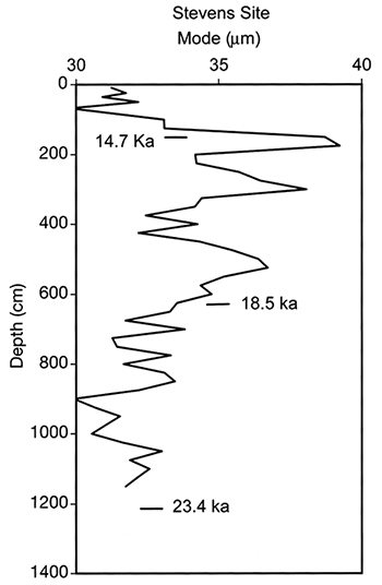
Peoria Loess (or Peoria Silt) can be correlated across the North American midcontinent. It was deposited generally within the period from 25 ka to 11 ka, but represents different intervals within that range in various parts of the midcontinent. Initial results of optically stimulated luminescence dating of Peoria Loess at the Stevens site (same locality as core 1-B-98, fig. 1-6B and 1-8) are shown in fig. 1-9. These three ages form a nearly linear age-depth trend, in contrast to the large changes in accumulation rate at the Loveland section (Stop 2). Of course, additional ages from this core (in progress) could reveal more variation in the accumulation rate.
Figure 1-9--Optically stimulated luminescence ages and grain-size variation within Peoria Loess at the Stevens site (same locality as Core 1-B-98, figs. 1-6B and 1-8). Modal diameter is calculated from particle-size distributions determined by laser diffraction.
Peoria Loess is at least 30 m thick in core 4-A-76 (Boellstorff, 1978), taken at Hummel Park, on the Missouri River bluff line immediately north of Omaha (the contact between Peoria Loess and Gilman Canyon Formation is difficult to identify in that core). Elsewhere, Peoria Loess ranges from 21 to 8 m thick on broad upland summits of the Omaha region. As elsewhere across the Great Plains and Midwest, Peoria Loess in cores collected in eastern Nebraska is light-yellowish-brown silt loam or silty-clay loam with minimal macroscopic evidence of pedogenic alteration below the surface soil profile. Thin sections consistently indicate a distinctive lenticular microstructure in Peoria Loess from the Omaha area. The origin of this microstructure is uncertain, although it resembles structures related to ice lens formation in cold-region soils (Van Vliet-Lanoe, 1985). In any case, this microstructure indicates relatively low levels of bioturbation during loess deposition, suggesting sparse vegetation, low primary productivity, and low abundance of soil fauna. In contrast, Peoria Loess from central and western Nebraska often displays more micromorphological evidence of soil biological activity, including faunal burrows and excrements and root channels. The clay mineralogy of Peoria Loess in the Omaha area is dominated by smectite, with much smaller amounts of illite and kaolinite. There is an abrupt decrease in smectite content between basal Peoria Loess and underlying Gilman Canyon Formation.
A common feature in many loess sections across the midcontinent is a coarsening upward in the upper one-half or one-third of the Peoria Loess, culminating in one or more grain-size peaks. Above these peaks, grain size decreases abruptly (unpublished data, 1. Mason). The Loveland section does not fit this pattern, probably because of varying loess input from highly proximal and distal sources. Peoria Loess north of Omaha does fit the pattern, as illustrated in fig. 1-9, despite the probability of multiple sources in this area as well. The grain-size peaks in the upper part of the section may represent strengthening westerly winds as the Laurentide ice sheet retreated.
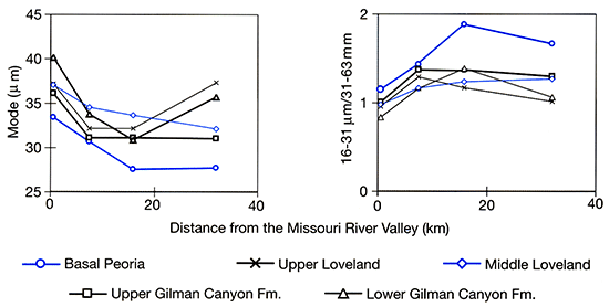
Thickness trends of loess units along two east-west transects north of Omaha, between the Missouri and Platte/Elkhorn valleys, are readily apparent in fig. 1-8. Peoria Loess thickness from sites on those transects and several other localities north of Omaha is also plotted against shortest distance to the Missouri in fig. 1-10. Most cores and test holes used to construct these figures are from ridge summits that are among the highest points in the local landscape, so thickness trends in these cores should be a reasonable approximation of trends in loess-deposition rate, relatively unmodified by post-depositional erosion. An important exception is core 3-B-98, collected on a lower spur ridge immediately adjacent to the Missouri Valley in an attempt to capture extremes of loess thickness there. The lower part of the loess section (below Gilman Canyon Formation) appears to be truncated in this core, suggesting that the core as a whole may underestimate loess-unit thicknesses. Figure 1-11 illustrates grain-size data from selected, clearly identifiable stratigraphic positions within the loess sequence. Insufficient data are available from the silty clays to include them here. The modal diameter is probably the single best index of the sorting of individual coarse silt and sand grains during loess transport. Ratios of grain-size fractions, such as 16-31 µm/31-63 µm, respond to sorting in transport but may also vary with changing proportions of fine silt and clay carried in larger sedimentary aggregates (Mason, Jacobs, Green, et al., 2003).
Figure 1-10--Peoria Loess thickness as a function of shortest distance to the western bluff line of the Missouri River valley, cores, and test holes north of Omaha (fig. 1-6B). The shortest distance in all cases is in a northeastward direction.
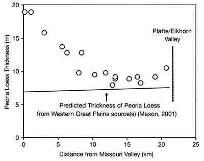
Figure 1-11--Grain size of selected samples from easily identified stratigraphic positions within the loess sequence in cores collected north of Omaha, plotted against distance from the Missouri Valley. "Middle Loveland Loess" is simply the midpoint of that unit in a given core, not a separate stratigraphic zone.
Both thickness and grain-size trends indicate that loess was transported westward from the Missouri Valley into Nebraska, at least as early as MIS 6 (the Illinoian glaciation), and probably earlier in the Middle Pleistocene. Peoria Loess and Loveland Loess clearly thin westward away from the Missouri Valley (excluding the anomalously thin Loveland in core 3-B-98). The Gilman Canyon Formation thins westward at sites near the Missouri, but elsewhere shows no clear trend; furthermore, the uncertainty in placement of the lower boundary is large relative to the total thickness of this unit. The silty clays as a whole also appear to thin westward, although more thickness measurements from this unit are needed. This suggests that the Missouri had already established its present course and was a significant loess source well before MIS 6, perhaps as early as 500-600 ka. Grain-size data clearly show that Peoria Loess, Gilman Canyon Formation, and Loveland Loess all become much finer with distance westward from the Missouri, over a distance of at least 20 km. The trends observed in Loveland Loess in Nebraska, combined with the well-established eastward thinning and fining of Loveland Loess in southwestern Iowa (Ruhe, 1969; Ruhe and Cady, 1967), indicate that the dispersal of glaciogenic loess from the Missouri Valley in MIS 6 followed a pattern similar to dispersal of Peoria Loess in MIS 2.
In spite of this strong evidence for persistent loess transport from the Missouri, much of the loess more than about 10 km west of the Missouri Valley may actually have come from major regional sources to the west on the Great Plains. This can be demonstrated for the Peoria Loess and should be considered as a possibility for older units as well. Across much of Nebraska, Peoria Loess thickness decreases eastward, indicating transport from northwestern sources (Mason, 2001). This trend can be extrapolated to the Omaha area, to predict the amount of western-source loess that should be present there, without any loess transport from the Missouri Valley. As shown in fig. 1-10, western-source, nonglaciogenic loess probably makes up over 50% of the total Peoria Loess thickness even at sites only 10 km from the Missouri Valley. With more work on available subsurface data and new cores in key locations, it may be possible to make a similar separation of Missouri Valley and western contributions to the Loveland Loess and silty clays.
The possibility of a third loess source in the Platte/Elkhorn Valley is hinted at but not strongly supported by grain size and thickness data from the Omaha area. A Platte/Elkhorn source should be indicated by a steep eastward decrease in thickness and grain size in the area immediately downwind (i.e., at the west end of transects shown in figs. 1-8, 1-10, and 1-11). These source-proximal trends should be distinguishable from very gradual eastward decreases in grain size and thickness of loess transported from the major Great Plains sources (note the very gradual eastward trend of predicted western-source Peoria Loess thickness in fig. 1-10). The modal diameters of the lower Gilman Canyon Formation and upper Loveland Loess do clearly become finer eastward from the Platte/Elkhorn Valley as well as westward from the Missouri (fig. 1-11). Similar trends are not evident for the modal diameters of other stratigraphic horizons, however. The 16-31 µm/31-63 µm ratios are slightly lower (indicating coarser loess) near the Platte/Elkhorn Valley than at sites midway between that valley and the Missouri, for most stratigraphic horizons. In figs. 1-8 and 1-10, Peoria Loess thickness increases slightly at the site farthest west from the Missouri and closest to the Platte/ Elkhorn. There is also anomalously thick Peoria Loess at drilling sites immediately east of the Platte/Elkhorn Valley southwest of Omaha, with 1.6 to 2 times the thickness predicted from regional western-source trends (these isolated sites are not included in fig. 1-10).
The outcrops across the river from our stop have been studied for many years, as the bluff face has actively retreated (Lueninghoener, 1947; Lugn, 1935; Reed and Dreeszen, 1965; Roy et al., 2004; Wayne, 1987). Most previous work has focused on the pre-Illinoian glacial tills exposed here. Reed and Dreeszen (1965) described tills of two separate "Kansan" glaciations, separated by the "Fontanelle soil." The latter appears to be more of an organic-rich silt than a well-developed soil and at present is not clearly visible from across the river. Roy et al. (2004) reported two tills, both with normal magnetic polarity; the composition of both units is similar to the younger pre-Illinoian tills at other sites.
The Fremont Bluffs section is also interesting from the standpoint of loess stratigraphy, mainly because of what is not there. Peoria Loess at the top of the section overlies the Gilman Canyon Formation, which in tum rests on a well-developed buried soil (a prominent red band crossing the entire exposure). Loveland Loess is thin (<2 m) or absent here, depending on when and where the section has been measured. Because he did not recognize any Loveland Loess here, Wayne (1987) identified the prominent reddish-brown soil as the "Yarmouth-Sangamon Paleosol," implying that soil formation started before the last interglacial (MIS 5). Whatever Loveland Loess is actually present is entirely contained within this soil, and the band of secondary carbonates below the reddish-brown Bt horizon (visible from across the river) is in glacial till. The silty clays appear to be completely absent here.
However, the Fremont Bluffs provide an example of the hazards of relying on outcrops to reconstruct loess stratigraphy, even impressive outcrops such as this one. The Fremont Bluffs exposures are unrepresentative of local loess stratigraphy. Mud-rotary test holes and cores on uplands south and north of the Platte Valley near Fremont (fig. 1-6A) clearly indicate the presence of a significant thickness of Loveland Loess and sediments equivalent to the silty clays north of Omaha.
The Todd Valley is one of the most striking geomorphic features in eastern Nebraska: a broad, well-defined valley containing no major stream, "hanging" above the valley of the Platte River at both northern and southern ends (fig. 1-6A). The Todd Valley was recognized quite early as a former valley of the Platte. Lugn (1935) and Lueninghoener (1947) proposed a straightforward autocapture mechanism to explain this feature, in which a tributary of the Elkhorn River captured the Platte near Fremont (fig. 1-6A). The Platte River has subsequently flowed through the former Elkhorn Valley for a short distance until rejoining its old course near Ashland, Nebraska (where I-80 crosses the Platte). Lueninghoener (1947) concluded that the capture occurred early in a "Peorian cycle" of erosion and subsequent alluviation along the Platte and Elkhorn rivers that was contemporaneous with Peoria Loess deposition on uplands.
Wayne (1987) advocated an alternative sequence of events, in which the Platte initially abandoned the Todd Valley prior to the late Pleistocene. Wayne proposed that the Missouri River was diverted down the present Elkhorn Valley by a late Wisconsin ice advance across the Missouri Valley into northeastern Nebraska. Where the diverted Missouri entered the Platte Valley, near Fremont, a fan was constructed, which in turn caused aggradation of the Platte and led that river to be briefly diverted into the Todd Valley once again. However, there is little stratigraphic or geomorphic evidence for the ice sheet advance into Nebraska and the diversion of the Missouri that Wayne (1987) proposed.
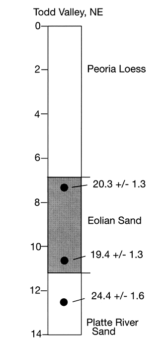
Stratigraphy within the Todd Valley is well known from hundreds of well logs and several geologic test holes and cores. Sand and gravel 30-45 m thick rests directly on Cretaceous bedrock. The gravel lithology appears similar to that of the modem Platte, although detailed provenance studies have not been done. Fine sand of variable thickness overlies the coarser sand and gravel and is in tum capped by Peoria Loess that is 5-10 m thick in most areas. The Gilman Canyon Formation or older loess units have not been identified within the valley, and there is no evidence of significant soil development within the entire sequence between the surface soil and bedrock. Peoria Loess thickness within the valley represents about 75-100% of Peoria thickness on adjacent uplands.
Based on this stratigraphy, fluvial occupation of the valley predates most of the time of Peoria Loess deposition. The absence of Loveland Loess and the Sangamon Geosol within the underlying sediment indicates that the final abandonment of the valley by the Platte occurred after MIS 6 and much of the subsequent MIS 5 interglacial. The fine sand beneath Peoria Loess is interpreted here as eolian sand, for the following reasons. The Todd Valley floor has a distinctive swell and swale topography similar to hummocky sand sheets or fields of low dunes, and some low hills in the valley resemble parabolic dunes. Well logs and a coring transect on University of Nebraska land southeast of Mead both indicate that Peoria Loess thickness is similar across both high and low points of the rolling valley floor and that much of the valley-floor topography is related to varying thickness of the fine sands.
This interpretation leads to the following scenario: During or just after Gilman Canyon Formation deposition, the Platte abandoned the Todd Valley. Extensive eolian sand activity then occurred on the abandoned valley floor, ending early in the period of Peoria Loess deposition. Accumulation of the final increment of Gilman Canyon Formation loess orthe initial increment of Peoria Loess could have been prevented by active eolian sand movement. Thus, the stratigraphy does not closely bracket valley abandonment within the Gilman Canyon Formation-to-early Peoria Loess interval.
We have recently obtained optical (OSL) ages from the uppermost fluvial sand, and the overlying fine sand interpreted as eolian (fig. 1-12). These ages indicate that the valley was abandoned between about 21 and 24 ka, and probably closer to the latter age. The ages are consistent with the stratigraphic evidence outlined above and would place the abandonment of the valley near the start of Peoria Loess deposition, so in a sense, Loeninghoener's estimated age for the capture was correct. The optical ages also raise the possibility that abandonment occurred around the same time as formation of the Fort Calhoun Terrace on the Missouri River (see discussion of the route between Council Bluffs and Stop 2). A causal connection between incision on the Missouri and abandonment of the Todd Valley is unclear, however. The stratigraphy within the valley does not provide any positive support for Wayne's concept of multiple occupations, although such evidence might have been eroded during the final occupation.
Figure 1-12--Optically stimulated luminescence ages from a core collected in the southeastern Todd Valley. Ages determined by Paul Hanson at the University of Nebraska Luminescence Dating Laboratory.
This work was partially supported by NSF grants EAR-00-87572 to Bettis and EAR-00-87916 to Mason. We thank the landowners of the sites for permission to work on their property and to allow our group access for this trip. Josh Been, USGS, and Geoff Duller, Luminescence Dating Laboratory, Institute of Geography and Earth Sciences, University of Wales, Aberystwyth, assisted with field sampling and laboratory analyses. Tom Stafford processed the AMS radiocarbon samples from the Loveland and Maas Drive sites. Paul Hanson carried out optical dating in the Todd Valley core. Drilling near Omaha was supported by the USGS through the STATEMAP Program and the Conservation and Survey Division, School of Natural Resources, University of Nebraska-Lincoln. CSD drillers Jim Roberts and Greg Grosch were instrumental in retrieving the subsurface data used here, with help from Byran Penas, Mike Ponte, Mike Beshore, Derek Geise, Paul Hanson, and numerous other UNL staff and students.
Aleinikoff, J. N., Muhs, D. R., and Fanning, C. M., 1998, Isotopic evidence for the sources of Late Wisconsin (Peoria) Loess, Colorado and Nebraska--Implications for paleoclimate; in, Dust Aerosols, Loess Soils, and Global Change. A. J. Busacca. ed.: Pullman, Washington, Washington State University, College of Agriculture and Home Economics. Miscellaneous Publication MISC0I90, p. 124-127.
Aleinikoff, J. N., Muhs, D. R., Sauer, R. R., and Fanning, C. M., 1999, Late Quaternary loess in northeastern Colorado II--Pb isotopic evidence for the variability of loess sources: Geological Society of America Bulletin, v. 111, p. 1,876-1,883.
Arbogast. A. F., and Muhs, D. R., 2000, Geochemical and mineralogical evidence from eolian sediments for northwesterly mid-Holocene paleowinds, central Kansas. USA: Quaternary International. v. 67, p. 107-118.
Baker, R. G., Bettis, E. A., III, and Huber, J. K., 2003, Vegetation on the eastern Great Plains, North America, during mid-Wisconsinan time--late MIS Stage 3-early MIS Stage 2: XVI INQUA Congress Programs with Abstracts, p. 164.
Baker, R. G., Rhodes, R. S., II, Schwert, D. P., Ashworth, A. C, Frest, T. 1., Hallberg. G. R., and Janssens, J. A., 1986, A full-glacial biota from southeastern Iowa, USA: Journal of Quaternary Science. v. I, p. 91-107.
Baker. R. G., Schwert, D. P., Bettis, E. A., III, Kemmis, T. J., Horton, D. G., and Semken, H. A., Jr., 1991, Mid-Wisconsin stratigraphy and paleoenvironment at the St. Charles site in south-central Iowa: Geological Society of America Bulletin. v. 103, p. 210-220.
Bettis, E. A., III, 1990, Holocene alluvial stratigraphy of western Iowa; in, Holocene Alluvial Stratigraphy and Selected Aspects of the Quaternary History of Western Iowa, E. A. Bettis, III, ed.: Midwest Friends of the Pleistocene. Annual Meeting [location varies], United States, [Midwest Friends of the Pleistocene], p. 1-72.
Bettis, E. A., III, Mason, J. P., Swineheart, J. B., Miao, X., Hanson, P. R., Goble, R. J., Loope, D. B., Jacobs, P. M., and Roberts, H. M., 2003, Cenozoic eolian sedimentary systems of the USA midcontinent; in, Quaternary Geology of the United States, D. J. Easterbrook, ed.: INQUA 2003 Field Guide Volume, Desert Research Institute, Reno, Nevada, p. 195-218.
Bettis, E. A., III, Muhs, D. R., Roberts, H. M., and Wintle, A. G., 2003, Last glacial loess in the conterminous U.S.A.: Quaternary Science Reviews. v. 22, p. 1,907-1,946.
Bettis, E. A., III, Quade, D. J., and Kemis, T. J., 1996, Hogs, bogs, and logs--Quaternary deposits and environmental geology of the Des Moines Lobe: Iowa Department of Natural Resources, Geological Survey Bureau Guidebook Series No. 18.
Boellstorff, J. D., 1978, A need for redefinition of North American Pleistocene stages: Transactions Gulf Coast Association of Geological Societies, v. 28, p. 65-74.
Curry, B. B., 1998, Evidence at Lomax, Illinois, for mid-Wisconsin (~40,000 yrs B.P.) position of the Des Moines Lobe and for diversion of the Mississippi River by the Lake Michigan Lobe (20,350 yrs B.P.): Quaternary Research. v. 50, p. 128-138.
Dorale, J. A., Edwards. L. A., Ito, E., and Gonzalez, L. A., 1998, Climate and vegetation history of the midcontinent from 75 to 25 ka--A speleothem record from Crevice Cave, Missouri, USA: Science, v. 282, p. 1,871-1,874.
Feng, Z. D., Johnson, W C., Lu, Y., and Ward, P. A., III, 1994, Climatic signals from loess-soil sequences in the central Great Plains, USA: Palaeogeography, Palaeoclimatology, Palaeoecology, v. 110, no. 3-4, p. 345-358.
Forman, S. L., and Pierson, J., 2002, Late Pleistocene luminescence chronology of loess deposition in the Missouri and Mississippi River valleys, United States: Palaeogeography, Palaeoclimatology, Palaeoecology, v, 186, no. 1-2, p. 25.
Forman, S. L., Bettis, E. A., III, Kemmis, T. J., and Miller, B. B., 1992, Chronologic evidence for multiple periods of loess deposition during the late Pleistocene in the Missouri and Mississippi River valley, United States--Implications for the activity of the Laurentide ice sheet: Palaeogeography, Palaeoclimatology, Palaeoecology, v. 93, no. 1-2, p. 71-83.
Frye, J. C., and Leonard, A. B., 1952, Pleistocene geology of Kansas: Kansas Geological Survey, Bulletin 99.
Hallberg, G. R., Harbaugh, J. M., and Witinok, P. M., 1979, Changes in the channel area of the Missouri River in Iowa, 1879-1976: Iowa Geological Survey, Special Report Series 1, 32 p.
Holliday. V. T., 1988, Mt. Blanco revisited--Soil-geomorphic implications for the ages of the upper Cenozoic Blanco and Blackwater Draw Formations: Geology, v. 16, p. 505-508.
Hunter, R. E., 1977, Basic types of stratification in small eolian dunes: Sedimentology, v. 24, p. 361-387.
Hutton, C. E., 1947, Studies of loess-derived soils in southwestern Iowa: Soil Science Society of America Proceedings, v. 12, p. 424-431.
Izett, G. A., and Wilcox, R. E., 1982, Map showing localities and inferred distributions of the Huckelberry Ridge. Meas Falls. and Lava Creek ash beds (Pearlette Family ash beds) of Pliocene and Pleistocene age in the western United States and southern Canada: U.S. Geological Survey, Miscellaneous Investigations Series, Map 1-1325.
Jacobs, P. M., and Knox, J. C., 1994, Provenance and petrology of a long-term Pleistocene depositional sequence in Wisconsin's Driftless Area: Catena (Giessen), v. 22, no. 1, p.49-68.
Lanphere, M. A., Champion, D. E., Christiansen, R. L., Izett, G. A., and Obradovich, J. D., 2002, Revised ages for tuffs of the Yellowstone Plateau volcanic field-Assignment of the Huckelberry Ridge Tuff to a new geomagnetic polarity event: Geological Society of America Bulletin, v. 114, p. 559-568.
Loope, D. B., and Swinehart, J. B., 2000, Thinking like a dune field--Geologic history in the Nebraska Sand Hills: Great Plains Research. v. 10, p. 5-35.
Lueninghoener, G., 1947. The post-Kansan geologic history of the lower Platte Valley area: University of Nebraska Studies, Lincoln, Nebraska, 82 p.
Lugn, A. L., 1935, The Pleistocene geology of Nebraska: Nebraska Geological Survey, Bulletin 10, 223 p.
Maat, P. B., and Johnson, W. C., 1996, Thermoluminescence and new 14C age estimates for late Quaternary loesses in southwestern Nebraska: Geomorphology, v. 17, p. 115-128.
Markewich, H. W, Wysocki, D. A., Pavich, M. J., Rutledge, E. M., Millard, H. T., Rich, F. J., Maat, P. B., Rubin, M., and McGeehin, J. P., 1998, Paleopedology plus TL, 10Be, and 14C dating as tools in stratigraphic and paleoclimatic investigations. Mississippi River valley. U.S.A: Quaternary International, v. 51-52, p. 143-167.
Martin, C. W., 1993, Radiocarbon ages on late Pleistocene loess stratigraphy of Nebraska and Kansas. central Great Plains: Quaternary Science Reviews, v. 12, p. 179-188.
Mason, J. A., 2001, Transport direction of Peoria Loess in Nebraska and implications for loess sources on the central Great Plains: Quaternary Research, v. 56, no. 1, p. 79-86.
Mason, J. A., and Kuzila, M. S., 2000, Episodic Holocene loess deposition in central Nebraska: Quaternary International. v. 67,p.119-131.
Mason, J. A., Jacobs, P. M., Hanson, P. R., Miao, X.-D., and Goble, R. J., 2003. Sources and paleoclimatic significance of Holocene Bignell Loess. central Great Plains. USA: Quaternary Research. v. 60, p. 330-339.
Mason, J. A., Jacobs, P. M., Greene, R. S. B., and Nettleton, W D., 2003, Sedimentary aggregates in the Peoria Loess of Nebraska. USA: Catena, v. 53, no. 4, p. 377-397.
Mason, J. A., Nater, E. A., and Hobbs, H. C., 1994, Transport direction of Wisconsinan loess in southeastern Minnesota: Quaternary Research. v. 41, p. 44-51.
May, D., Swineheart, J. B., Loope, D., and Souders, V., 1995, Late Quaternary fluvial and eolian sediments-Loop River basin and the Nebraska Sand Hills; in, Geologic Field Trips in Nebraska and Adjacent Parts of Kansas and South Dakota. C. A. Flowerday, ed.: Conservation and Survey Division. Institute of Agriculture and Natural Resources. University of Nebraska-Lincoln. Guidebook 10, p. 13-31.
May, D. W, and Holen, S. R., 1993. Radiocarbon ages of soils and charcoal in late Wisconsinan loess, south-central Nebraska: Quaternary Research. v. 39, p. 55-58.
Miller, R. D., 1964, Geology of the Omaha-Council Bluffs area, Nebraska-Iowa: U.S. Geological Survey, Professional Paper 472.
Muhs, D. R., Aleinikoff. J. N., Stafford, T. W. J., Kihl, R., Been, J., Mahan, S. A., and Cowherd, S. D., 1999. Late Quaternary loess in northeastern Colorado--Part I. Age and paleoclimatic significance: Geological Society of America Bulletin, v. 111, p. 1.861-1.875.
Muhs, D. R., and Bettis, E. A., III, 2000, Geochemical variations in Peoria Loess of western Iowa indicate paleowinds of midcontinental North America during last glaciation: Quaternary Research, v. 53. no. 1, p. 49-61.
Muhs, D. R., Bettis, E. A., III, Been, J., and McGeehin, J. P., 2001. Impact of climate and parent material on chemical weathering in loess-derived soils of the Mississippi River valley: Soil Science Society of America Journal, v. 65, p. 1.761-1.777.
Muhs, D. R., and Bettis, E. A., III, 2003, Quaternary loess-paleosol sequences as examples of climate-driven sedimentary extremes; in, Extreme Depositional Environments--Mega End Members in Geologic Time, M. A. Chan and A. W Archer, eds.: Geological Society of America. Special Paper 370, p. 53-74.
Muhs, D. R., Swinehart, J. B., Loope, D. B., Aleinikoff, J. N., and Been, J., 1999, 200,000 years of climate change recorded in eolian sediments of the High Plains of eastern Colorado and western Nebraska; in, Colorado and Adjacent Areas, D. R. Lageson, A. P. Lester, and B. D. Trudgill. eds.: Geological Society of America Field Guide 1, p. 71-91.
Péwé, T. L., 1951, An observation on wind-blown silt: Journal of Geology, v. 59, p. 399-401.
Péwé, T. L., 1983, The periglacial environment in North America during Wisconsin time; in, Late Quaternary Environments of the United States, Volume I, The Late Pleistocene, H. E. Wright, Jr., and S. C. Porter, eds.: Minneapolis, University of Minnesota Press, p. 157-189.
Pye, K., Winspear, N. R., and Zhou, L. P., 1995, Thermoluminescence ages of loess and associated sediments in central Nebraska, U.S.A.: Palaeogeography, Palaeoecology, Palaeoclimatology. v. 118, p. 73-87.
Reed, E. C., and Dreeszen, V. H., 1965, Revision of the classification of the Pleistocene deposits of Nebraska: Nebraska Geological Survey, Bulletin 23, 65 p.
Roberts, H. M., Muhs, D. R., Wintle, A. G., Duller, G., and Bettis, E. A., III, 2003, Unprecedented last glacial mass accumulation rates determined by luminescence dating of loess from western Nebraska: Quaternary Research. v. 59, p. 411-419.
Roy, M., Clark, P. U., Barendregt, R. W. Glasmann. J. R., and Enkin, R. J., 2004, Glacial stratigraphy and paleomagnetism of late Cenozoic deposits of the north-central United States: Geological Society of America Bulletin. v. 116, p. 30-41.
Ruhe, R. V., 1967, Geomorphology of parts of the Greenfield quadrangle, Adair County, Iowa, chapter 2; in, Landscape Evolution and Soil Formation in Southwestern Iowa, R. V. Ruhe, R. B. Daniels. and J. G. Cady. eds.: U.S. Department of Agriculture, Technical Bulletin 1349, p. 93-161.
Ruhe, R. V., 1969, Quaternary landscapes in Iowa: Ames, Iowa State University Press, 255 p.
Ruhe, R. V., 1983, Depositional environment of late Wisconsin loess in the midcontinental United States; in, Late Quaternary Environments of the United States- Volume I, The Pleistocene, H. E. Wright, Jr., and S. C. Porter, eds.: Minneapolis, University of Minnesota Press, p. 130-137.
Ruhe, R. V., and Cady, J. G., 1967, The relation of Pleistocene geology and soils between Bentley and Adair in southwestern Iowa, chapter I; in, Landscape Evolution and Soil Formation in Southwestern Iowa. R. V. Ruhe, R. B. Daniels, and J. G. Cady, eds.: U.S. Department of Agriculture, Technical Bulletin 1349, p. 1-92.
Ruhe, R. V., Miller, G. A., and Vreeken, W J., 1971, Paleosols, loess sedimentation, and soil stratigraphy--Paleopedology, origin, nature, and dating of paleosols: Jerusalem, Israel University Press, p. 41-60.
Schwert, D. P., Torpen-Kreft, H. J., and Hajic, E. R., 1997, Characterization of the late-Wisconsinan tundra/forest transition in midcontinental North America using assemblages of fossil beetles: Quaternary Proceedings, v. 5. p.237-243.
Shimek, B., 1896, A theory of the loess: Iowa Academy of Science Proceedings, v. 3, p. 82-89.
Shimek, B., 1898, Is the loess of aqueous origin?: Iowa Academy of Science Proceedings, v. 5, p. 32-45.
Smith, G. D., 1942, Illinois loess--Variations in its properties and distribution, a pedologic interpretation: University of Illinois, Agricultural Experiment Station, Bulletin 490, p. 139-184.
Snowden, J. O., and Priddy, R. R., 1968, Geology of Mississippi loess: Mississippi Geological Survey, Bulletin 111, p. 13-203.
Thompson, M. L., and Soukup, T. A., 1990, Morphological characterization of a suite of buried and exhumed Sangamon Paleosols in Pottawattamie County, Iowa; in, Holocene Alluvial Stratigraphy and Selected Aspects of the Quaternary History of Western Iowa, E. A. Bettis, III, ed.: Midwest Friends of the Pleistocene, Annual Meeting [location varies], United States, p. 175-183.
Thorp, J., Johnson, W, and Reed. E. C., 1951, Some post-Pliocene buried soils of the central United States: Journal of Soil Science, v. 2, p. 1-19.
Van Vliet-Lanoe, B., 1985, Frost effects in soils; in, Soils and Quaternary Landscape Evolution, J. Boardman, ed.: New York, Wiley, p. 117-160.
Wang, H., Follmer, L. R., and Liu, J. C., 2000, Isotopic evidence of paleo-El Nino-Southern Oscillation cycles in loess-paleosol record in the central United States: Geology, v. 28, p.771-774.
Wayne, W. J., 1985, Drainage patterns and glaciations in eastern Nebraska: Nebraska Academy of Sciences Institute for Tertiary-Quaternary Research Symposium Series, v, 1, p. 111-117.
Wayne. W J., 1987, The Platte River and Todd Valley. near Fremont, Nebraska; in, North-central Section of the Geological Society of America, Centennial Field Guide, v. 3, D. L. Biggs, ed.: Geological Society of America, p. 19-22.
Prev--Report Start || Next--Pre-Meeting Field Trip 2
Kansas Geological Survey
Comments to webadmin@kgs.ku.edu
Web version July 7, 2014. Original publication date 2006.
URL=http://www.kgs.ku.edu/Publications/Bulletins/TS21/field_trip1.html