Kansas Geological Survey, Subsurface Geology Series 2, originally published in 1975
with maps showing the thickness of potentially oil-bearing formations
Originally published in 1975 as Kansas Geological Survey Subsurface Geology Series 2. This is, in general, the original text as published. The information has not been updated.
The author expresses his gratitude to the many colleagues whose helpful discussion contributed to this report. The following persons were particularly helpful in reviewing the manuscript: Robert F. Walters, Edwin G. Goebel, Paul L. Hilpman, and W. J. Ebanks, Jr. Kaye Long typed the copy for the text.
Ordovician and Cambrian stratigraphic units occur in Kansas only in the subsurface. Information concerning these rocks, consequently, is derived from drilling of deep wells, during which the nature and thickness of various recognizable formations penetrated is recorded. This set of four maps displays the information from thousands of wells such as these drilled in Kansas, and records the generally accepted interpretations of experienced oil-industry geologists, current, at least, to the date of compilation, 1965. Later drilling activity, for example that occurring in Coffey County in 1972-1974, may modify these interpretations somewhat, especially the projected limits or "zero" thickness contours of some strata. Thus, although the drilling which resulted in these maps spans several decades, and the money and manpower invested in the acquisition of these data are enormous, the maps should be considered only a progress report; the facts they describe are only ideas or judgments to be tested. That is the essence of subsurface exploration geology.
The Ordovician and Cambrian strata beneath the surface in Kansas presumably are equivalent to rocks of similar age in adjacent states, Iowa, Missouri, and Oklahoma (Merriam, 1963; Huffman, 1959). In those states the rocks have been studied in surface exposures and carefully subdivided on paleontologic evidence, as well as lithologic character. As most of the material used for studies of subsurface formations is in the form of well-cuttings, the opportunity for paleontologic study is greatly reduced. A possible exception, which offers some hope for the future, is the study of various acid-insoluble phosphatic or siliceous microfossils. The best determinations of correlation between subsurface stratigraphic sections probably will derive from studies which combine lithologic and paleontologic data.
These remarks explain why, in mapping the subsurface extent of the Ordovician-Cambrian rock units, it has been necessary to lump formational units, recognizable at the surface, into more inclusive groups [Figure 1]. The subsurface nomenclature which has developed, consequently, is not exactly parallel to the accepted surface terminology. This applies especially to the "Arbuckle" Group, as shown here on Map 1. Furthermore, additional work, such as that recently completed in Missouri, (Kurtz, et al,, in prep.), whether correct or not, questions the identity of certain Cambrian stratigraphic units in the subsurface and demands further study of their equivalents in adjacent areas.
Despite the limitations of subsurface correlation techniques, certain traceable Ordovician and Cambrian rock units have been identified in the Kansas subsurface which are important as reservoirs of oil and gas in many areas of the state; as zones for deep-disposal of salt water co-produced with this oil and gas or with that from shallower formations, and, in other areas, as aquifers of fresh water for industrial, municipal, and agricultural use. The accompanying maps describe the extent of these rock units and provide a basis for further deep exploration drilling.
Figure 1--Classification of time and rock stratigraphic units.
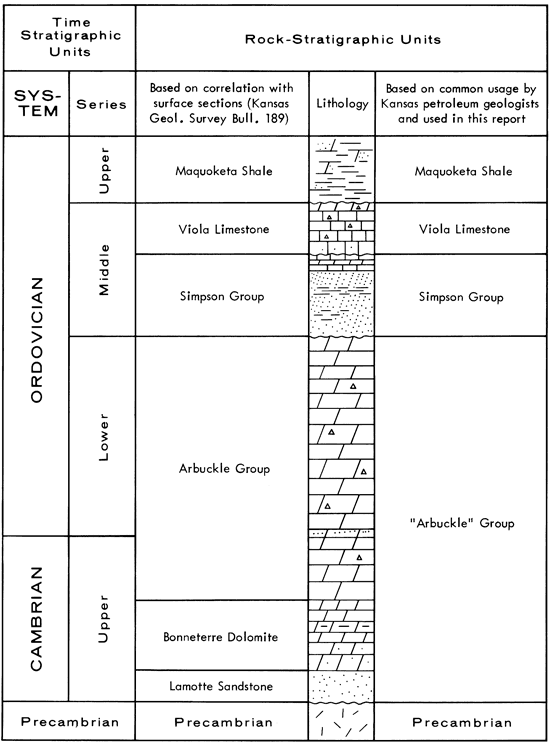
Usage dictates that, in Kansas subsurface stratigraphic practice, the term "Arbuckle" Group includes all sedimentary rocks beneath the Middle Ordovician Simpson Group, or younger beds where this is absent, and above the Precambrian igneous or metamorphic basement rocks. Some Upper Cambrian units not grouped with the Ordovician Arbuckle Group in surface stratigraphy, specifically the LaMotte Sandstone and Bonneterre Formation-Reagan Sandstone, are included with the "Arbuckle" Group in this report. With this definition, as is apparent from Map 1, the "Arbuckle" is present in most of Kansas. It is absent only in areas of northeastern and northwestern Kansas over the crests of ancient uplifts and in other scattered localities over the crests of buried Precambrian "hills" (Cole, 1962; Denison, 1966; Walters, 1946).
"Arbuckle" Group rocks occur at depth ranging from about 500 feet in southeastern Kansas to more than 5000 feet in southwestern Kansas. These units thicken, as a whole, from north to south and are thickest, 1390 feet, in the southeastern corner of the state. In general, the younger "Arbuckle" strata, uppermost Cambrian and Lower Ordovician dolomites, are the most widespread. Large areas with no "Arbuckle" probably were areas of erosional removal of the deposits. Without a more detailed subdivision of the "Arbuckle," the effects of non-deposition as opposed to erosion cannot be sorted out (Chenoweth, 1968).
"Arbuckle" Group rocks comprise dolomite, sandy or cherty dolomite, and sandstone, all of which may have excellent porosity and permeability. There is almost no shale in the "Arbuckle" except at the top of the section, beneath the shaly Simpson beds.
The oldest subsurface "Arbuckle" rocks, probably partly equivalent to other basal Paleozoic units in adjoining states, are mostly quartz sandstone and sandy carbonate rocks. Basal, more feldspathic, "granite wash" sandstone occurs in many areas just above the Precambrian contact, and may be of widely varying age from area to area. These sandstone beds are usually coarsest at the base. Individual quartz grains are rounded but may be covered with a drusy overgrowth, appearing like tiny crystals. As much as ninety feet of basal sandstone is present in Russell County, Kansas.
Above the basal clastic deposits, "Arbuckle" rocks comprise mostly dolomite. These dolomite beds, in the lower parts of the section, are light gray or white and contain almost no sand or chert impurities. Above these light gray or white beds, the "Arbuckle" consists of sandier, buff or light-brown dolomites which vary alternately from coarser to finer texture. Near the change in types of dolomite in the "Arbuckle," numerous workers (McQueen, 1931; McCracken, 1964; Chenoweth, 1968), have recognized a very sandy carbonate layer which they have equated with the Gunter Sandstone of Missouri, suggesting that it represents the transition between Cambrian and Ordovician periods of deposition.
Ordovician "Arbuckle" dolomites are, in general, sandier and contain more chert than earlier carbonates. Some workers, (Keroher and Kirby, 1948; McCracken, 1952; Davies, 1962) have used these insoluble residues of the carbonate rocks as the basis for subdividing the upper "Arbuckle," noting various kinds of microscopically diagnostic sand grains and chert textures. The most noteworthy type of chert, and that which distinguishes "Arbuckle" from younger dolomite beds in well cuttings, is "oolitic," or concentrically banded, chert. Individual, coarse-sand size, chert particles commonly have a "sparkly" appearance which is different from the duller vitreous, translucent appearance of chert occurring lower in the "Arbuckle."
The base of the "Arbuckle," as noted above, is unconformable with the underlying basement rocks and beneath Kansas this contact may vary from Cambrian to upper Lower Ordovician in age. At the top, "Arbuckle" is overlain unconformably by Middle Ordovician Simpson sandstone and shale. Where the Simpson is absent, the "Arbuckle" is difficult to distinguish from younger dolomites, especially in well samples. The oolitic chert described above is distinctive of the "Arbuckle" and may aid in this separation. In areas of greatest uplift since Ordovician time "Arbuckle" beds may be overlain by beds as young as Pennsylvanian (Merriam, 1963, Fig. 95).
The Simpson Group comprises sandstone, shale, and carbonate beds occurring above the "Arbuckle" rocks and beneath the Viola Limestone. This variable sequence of Middle Ordovician beds is missing in large areas of northwestern and southeastern Kansas and thickens to a maximum of about 250 feet in Harper County near Oklahoma. These Simpson beds are equivalent to parts of thicker sections in Oklahoma and Iowa (Ireland, 1966; Schramm, 1964).
Sandstone and shale are the most important types of rocks in the Simpson in south-central Kansas, although some sandy, shaly dolomite is present. Both southwestward and northeastward in the state dolomite with interbeded shale becomes more important, although the persistent St. Peter Sandstone remains present there.
Sandstone in the Simpson is mostly white or light gray, quartz-rich, and cemented by carbonate or silica. Glauconite in the sandstone and the typical green color of the shales combine to give many Simpson samples their "greenish cast," often noted on sample-logs. Other Simpson shales may be gray with traces of phosphate and a waxy luster.
In northeastern and north-central Kansas a persistent limestone unit in the upper Simpson thickens northeastward to as much as 100 feet in Brown County while lower sandier beds thin in that direction. The limestone is correlated to the Platteville Formation of Iowa (Lee, 1956; Leatherock, 1945).
Simpson strata are separated from the "Arbuckle" Group below and overlying Viola Limestone by minor unconformities. Unusually thick sections of Simpson in some local areas have been interpreted as fillings of Ordovician sinkholes (Lee, et al., 1946) in the "Arbuckle." Unconformity with the Viola is more subtle.
Middle Ordovician Viola Limestone beds are widely distributed in the subsurface of Kansas. It comprises those limestone and dolomite beds between the Simpson Group and the overlying Maquoketa Shale. The areas where Viola is not present conform generally to areas where the underlying Simpson is absent, that is in southeastern and northwestern Kansas and over the crests of the major uplifts in the central and northeastern parts of the state. The Viola section is thickest, more than 300 feet, in north-central Kansas, in Jewell County. Lee (1956) has discussed the implications of the various patterns of Viola thickness change to paleogeography of the Middle Ordovician. Chenoweth (1966) described the geology of Viola oil and gas fields in Kansas and adjoining states.
The Viola section includes mostly limestone in northeastern and eastern Kansas, but farther west more of the beds are dolomite. In central Kansas, limestone is interbedded with dolomite and the Viola is very cherty. Farther north, toward Nebraska, the Viola is almost all dolomite. Unlike units above and below, Viola carbonate rocks contain very little sandy impurity and there are few shaly interbeds (Davies, 1962; Carmody, 1958; Biederman, 1966). Carmody (1958) suggested informal subdivision of the Viola in central, southern, and southwestern Kansas into lettered units in the following order from the base upward: "Viola A," a fairly thin non-cherty dolomite or, less often, limestone; "Viola B," a thick cherty dolomite; "Viola C," thin limestone, commonly absent; and "Viola D," dolomitic shale to dolomite. Where the Simpson Group rocks are absent, it is very difficult to distinguish dolomites of the Viola and Arbuckle.
Regional studies (Lee, 1956) have shown that the Viola Limestone is unconformable with the underlying Simpson Group. Relation of the Viola to overlying units is not so clear. Upper Ordovician Maquoketa (Sylvan) Shale seems in some places to overlie Viola disconformably, while farther west, where the Maquoketa includes more carbonates, the two seem indistinguishable (Lee, 1956). In the Hugoton Embayment of southwest Kansas, where the Viola is recorded as being more than 200 feet thick, Goebel, et al. (1969) have suggested that some of the upper "Viola" may actually be Devonian. Difficulty in distinguishing between these deeply buried limestone-dolomite sequences in well-samples prevents an easy resolution of this problem.
The Maquoketa Shale is an argillaceous Late Ordovician unit, presumably equivalent to the Sylvan Shale in Oklahoma, which is of similar age. It is the least widespread of the Ordovician strata beneath Kansas. Maquoketa is absent in widespread areas of southern and western Kansas and over the crest of the Nemaha Uplift in northeastern Kansas. The maximum thickness of this unit occurs in east-central Kansas, where more than 170 feet of rocks have been assigned to the Maquoketa. Lee (1956) and Adkison (1972) ascribed the absence of these Upper Ordovician beds from much wider areas to later erosion. Occurrence of Maquoketa in isolated areas, such as in Stafford-Edwards counties supports this view. These authors noted too, however, that in some cases there may be misidentification of Maquoketa with units older and younger than itself, especially where the Maquoketa is mostly carbonate, near its western extent. In any case, this Upper Ordovician unit is as variable in thickness as it is in lithology.
Maquoketa Shale includes pale green or greenish-gray dolomitic shale, or gray pyritic shale, and dolomite which is gray or buff and very argillaceous or even cherty. There probably is much interbedding of these types of rocks, but this cannot be documented because of poor preservation of samples of Maquoketa in well cuttings. Lee (1956) emphasized that the main distinction between Maquoketa and Viola carbonate rocks is the presence in the former of abundant argillaceous or sandy impurities, as opposed to the nonargillaceous, sucrosic texture of the latter.
The Maquoketa Shale unconformably overlies the Viola Limestone and is not as extensive areally as the Viola. The upper contact of the Maquoketa varies from a minor disconformity with the Silurian, where that unit is present, to a drastic erosional unconformity in which Maquoketa is overlain by Chattanooga Shale.
The following list of wells in which the Cambrian-Ordovician strata beneath Kansas have been penetrated is offered here as an aid to readers who may wish to initiate further study. These wells were selected as representative of the stratigraphy in different areas of the state and are all described in sample-logs available through the Kansas Geological Society, Wichita, Kansas.
| Company | Well | Spot | Section, Township, Range |
County |
|---|---|---|---|---|
| Davon | Schaefer 1 | NW NW SW | 20-1S-6E, | Marshall |
| Jones & Pellow | Pohl 1 | SW SW SE | 14-7S-21E | Atchison |
| Morris | Davis 2 | NE SW NW | 6-25S-5E | Butler |
| McGinnis | Fee 4 | SE NW SW | 25-26S-12E | Greenwood |
| Ross & Keas | Solomon 1 | NW SE NW | 29-26S-17E | Woodson |
| Gore | West 1 | C NE SE | 17-31S-21E | Labette |
| Murfin | Wesling 1 | SE SE NE | 35-6S-7W | Mitchell |
| Mid-Kansas | Boyce 1 | SE SE NW | 18-6S-13W | Osborne |
| Gulf States | St. John 5 | NE SW SE | 27-8S-25W | Graham |
| Mid-Kansas | Kline 1 | SW SW SE | 19-14S-24W | Trego |
| Magnolia | Schroeder 6 | CEL NW SW | 26-16S-10W | Ellsworth |
| Skelly | Slocum 1 | NW NW SE | 2-28S-27W | Gray |
| Stanolind | Wheatley 1 | C NE SW | 13-33S-31W | Seward |
| Mobil | Cunningham 1 | C SW SE | 13-34S-37W | Stevens |
Adkison, W.L., 1972, Stratigraphy and structure of Middle and Upper Ordovician rocks in the Sedgwick Basin and adjacent areas, South-Central Kansas: U.S. Geological Survey, Prof. Paper 702, 33 p. [available online]
Biederman, E.W., Jr., 1966, Petrology of the Viola Formation, El Dorado Field, Butler County, Kansas: Tulsa Geol. Soc., Digest, v. 34, p. 41-60.
Carmody, R.A., 1958, personal communication.
Chenoweth, P.A., 1968, Early Paleozoic (Arbuckle) overlap, southern Mid-Continent, United States: Am. Assoc. Petroleum Geologists, Bull., v. 52, no. 9, p. 1670-88.
Chenoweth, P.A., 1966, Viola oil and gas fields of the Mid-continent: Tulsa Geol. Soc. Digest, v. 34, p. 110-19.
Cole, V.B., 1962, Configuration of the Precambrian basement rocks in Kansas: Kansas Geol. Survey, Oil and Gas Investigations No. 26, 1 map.
Davis, J.D., 1962, personal communication.
Decker, C.E., and Merritt, C.A., 1931, The stratigraphy and physical characteristics of the Simpson Group: Okla. Geol. Survey, Bull. 55, p. 1-112.
Denison, R.E., 1966, Basement rocks in adjoining parts of Oklahoma, Kansas, Missouri, and Arkansas: unpub. Ph.D. Diss., University of Texas.
Goebel, E.D., 1968, Cambrian-Ordovician Systems; in, The Stratigraphic Succession in Kansas, D.E. Zeller, ed.: Kansas Geol. Survey, Bull. 189, p. 11-15. [available online]
Goebel, E.D., Sweet, W.C., and Hilpman, P.L., 1969, Late Devonian age of a mixed conodont fauna from a core in southwestern Kansas (abs.): Geol. Soc. Amer., North-Central Section, annual meeting.
Huffman, G.G., 1959, Pre-Desmoinesian isopachous and paleogeologic studies in central Mid-continent region: Am. Assoc. Petroleum Geologists, Bull., v. 43, p. 2541-75.
Ireland, H.A., 1966, Resume and setting of Middle and Upper Ordovician stratigraphy, Midcontinent and adjacent regions: Tulsa Geol. Soc., Digest, v. 34, p. 26-41.
Keroher, R.P. and Kirby, J.J., 1948, Upper Cambrian and Lower Ordovician rocks in Kansas: Kansas Geol. Survey, Bull. 72, 140p. [available online]
Kurtz, V.E., Thacker, J.L., Anderson, K.H., and Gerdemann, P.E., in preparation, Traverse in Late Cambrian strata from the St. Francois Mountains, Missouri, to Delaware County, Oklahoma: Missouri Geol. Survey and Water Resources, 155 p.
Leatherock, C., 1945, The correlation of rocks of Simpson age in north-central Kansas with the St. Peter sandstone and associated rocks in northwestern Missouri: Kansas Geol. Survey, Bull. 60, pt. 1, 16 p. [available online]
Lee, Wallace, 1956, Stratigraphy and structural development of the Salina Basin area: Kansas Geol. Survey, Bull. 121, 167p. [available online]
McCracken, Earl, 1955, Correlation of insoluble residue zones of upper Arbuckle of Missouri and southern Kansas: Am. Assoc. Petroleum Geologists, Bull., v. 39, no. 1, p. 47-59.
McCracken, M.H.,1964, The Cambro-Ordovician rocks of northeastern Oklahoma and adjacent areas: Tulsa Geol. Soc., Digest, v. 32, p. 49-76.
McQueen, H.S., 1931, Insoluble residues as a guide in stratigraphic studies: Missouri Bureau of Geology and Mines, Biennial Report of the State Geologist, 1929-1930, p. 102-131.
Merriam, D.F., 1963, The geologic history of Kansas: Kansas Geol. Survey Bull., 162, 317 p. [available online]
Schramm, M.W., 1964, Paleogeologic and quantitative lithofacies analysis, Simpson Group, Oklahoma: Am. Assoc. Petroleum Geologists, Bull., V. 48, p. 1164-96.
Walters, R.F., 1946, Buried Precambrian hills in northeastern Barton County, Central Kansas: Am. Assoc. Petroleum Geologists, Bull., v. 30, no. 5, p. 660-710.
Kansas Geological Survey, Subsurface Ordovician-Cambrian Rocks in Kansas
Placed on web June 15, 2009; originally published in 1975.
Comments to webadmin@kgs.ku.edu
The URL for this page is http://www.kgs.ku.edu/Publications/Bulletins/Sub2/index.html