Kansas Geological Survey, OGI 16
Originally published in 1958 as Kansas Geological Survey Oil and Gas Investigations 16. This is, in general, the original text as published. The information has not been updated. An Acrobat PDF version (40.2 MB) is also available.
On the basis of Kansas Geological Survey records, oil and gas reservoirs of Kansas have been classified into eighteen zones, the geographic and geologic aspects of which are discussed briefly. An accompanying plate shows the name and location of currently producing oil and gas fields, and includes a list of abandoned and discontinued fields. A second plate shows, zone by zone, the distribution of oil and gas reservoirs.
In 1859, at Titusville, Pennsylvania, E. L. Drake tried to increase production of oil from a seep by drilling a hole through soil and bedrock to the "source beds" below. The venture proved successful and the petroleum industry in the United States was born. Ever since that time men have attempted to find a more effective way to discover oil. Within a few years after Drake's well was completed, most of the surface oil seeps had been exploited—already a new approach was needed. Hunt (1861) published the anticlinal theory, the application of which only temporarily solved the problem, for when no more anticlines could easily be found on the surface by geologists, drilling activity again declined. These early efforts afforded the geologist a wealth of new data about buried strata and the true nature of structural and stratigraphic traps, however, and subsurface methods became prominent in the search for oil and gas. Today, with the aid of modern geophysical tools, subsurface geology has become firmly entrenched as the most effective means of petroleum exploration. Yet statisticians warn that new methods still must be found if the industry is to continue to meet the demand for petroleum products. At present petroleum is our major source of energy and, despite the advent of atomic energy, must remain so for the next ten years if the nation's demands are to be met.
This study is not intended to be used primarily as a reference or guide to the oil and gas fields of Kansas, for the present rate of drilling activity indicates that by the time the manuscript has been printed, the maps will already be out of date. Rather, it is offered as a "work sheet" to be used by the geologist in his search for new production in the state, in the hope that the maps may suggest some clue to pools not yet discovered. The maps present objectively the distribution of oil and gas at given times (stratigraphic positions). Fields discovered or abandoned since the compilation of this report may change the local picture, but county and regional relationships remain essentially unchanged. A supplementary tabulation (Pl. 1) provides data for pools that are depleted or nearly so but which none the less concern the history of production and may affect future petroleum exploration. The short text is intended to clarify the diagrams and to define the various oil and gas zones as the terms are used in this report.
Thanks are expressed to the Kansas Geological Society Nomenclature Committee for making available its records. Many persons associated with the petroleum industry have contributed their time and information: A. M. Bruner, Shell Oil Company; V. B. Cole, Gulf Oil Corporation; O. C. Farquhar, Visiting Professor of Geology at Kansas University; R. F. Walters, Walters Drilling Company; and R. L. Winchell, Department of Geology, Kansas University.
On the basis of production data reported to the State Geological Survey over a period of more than 40 years, producing reservoirs within the state have been classified in eighteen major stratigraphic zones, as follows:
Each zone is discussed briefly and the names of some formations included in each zone are listed. It should be noted, however, that the list includes both "time" and "rock" unit names. The names have been chosen because of their general acceptance and use in the petroleum industry. On a single large map (Pl. 1), the name and outline of currently producing fields are shown. The Hugoton and Greenwood Gas Areas have been omitted from this plate because of their vast expanse, but are shown on Plate 2. In addition, an attempt has been made to show, by coded symbols on Plate 1, the name and location of all "abandoned and discontinued" fields. Included within the category of "abandoned and discontinued" are all fields that have been officially abandoned by the Kansas Nomenclature Committee as of October 1, 1956, and fields from which no production was reported during 1955 and 1956. The "abandoned and discontinued" fields are tabulated on the margin of Plate 1 along with available information on the location of discovery wells and type of production (i. e., oil, gas, oil and gas).
Plate 2 consists of a series of maps, which show, zone by zone, the geographic distribution of currently producing oil and gas fields. Producing fields are defined in the report as follows:
It should be pointed out that producing outlines are shown rather than field delineations as defined by the Nomenclature Committee. Also, because it was not possible to show the exact area from which a given zone produces in a given field, the entire producing outline of a field is shown if any portion of that field produces from a given zone.
During compilation of this report it became apparent that through the years many statistical errors have been introduced and perpetuated in the records. Where such errors appear in this publication, the reader is encouraged to bring them to the attention of the Oil and Gas Division, State Geological Survey.
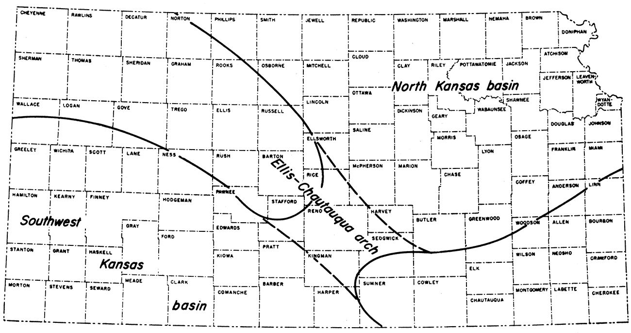
It is well known that any study of areas of oil and gas accumulation must naturally be coupled with a study of the tectonic features in the region. In Kansas, the stratigraphic and structural development (Jewett, 1951) reflects two generations of structural provinces, the time of development of the second group being indicated by a widespread unconformity between the Pennsylvanian strata and the underlying rocks.
The pre-Mississippian provinces (Fig. 1) consist of the Southwest Kansas Basin and the North Kansas Basin separated by the northwest-trending Ellis-Chautauqua Arch. During early Paleozoic time these basins and uplifts were the site of considerable deposition. Today the deposits are best preserved in the basins. The absence of Silurian-Devonian ("Hunton") strata from the Southwest Kansas Basin suggests that this area became a high sometime prior to Mississippian time.
Figure 1—Pre-Mississippian structural provinces in Kansas.
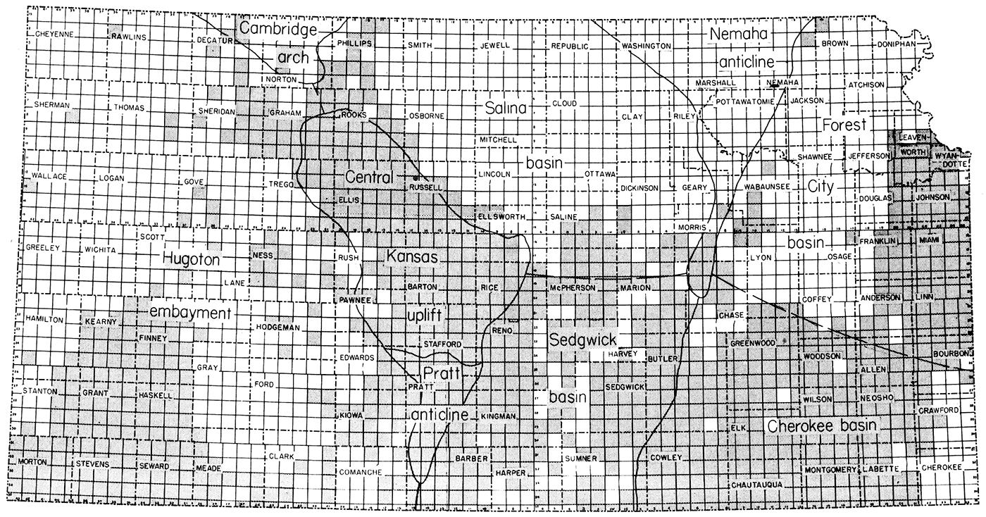
In post-Mississippian time, the Central Kansas Uplift was more or less superimposed on the Ellis Arch, and the Nemaha Anticline rose to divide the ancestral North Kansas Basin into the Salina Basin to the west and the Forest City Basin to the east. Farther south the Nemaha Anticline is flanked by the Cherokee Basin to the east and the Sedgwick Basin to the west. The Southwest Kansas Basin became the Hugoton Embayment of the Anadarko Basin.
Because the post-Mississippian structures are superimposed on the ancestral pre-Mississippian features, it is to be expected that the younger group of structures exerts greater control on the location of oil and gas traps. For this reason, the post-Mississippian provinces have been outlined on Plate 1. It should be borne in mind, however, that the distribution of petroleum traps in lower Paleozoic strata is controlled in part by the pre-Mississippian structure.
The outlines of the post-Mississippian structural provinces are shown also in Fig. 2, which shows all townships from which commercial production has been recorded, regardless of quantity, type, or producing zone. Some of the provinces are completely covered with producing townships, others seem devoid of production, and still others are outlined by production along their margins. A relationship to the structural provinces is clearly indicated.
Figure 2—Map of Kansas oil and gas producing townships of record.
Production from the Precambrian zone has been reported in seven fields; some unit names included within the category are: Precambrian granite and granite wash.
Although generally termed granite, the Precambrian basement rocks comprise a variety of lithologies including granite, porphyry, gneiss, schist, slate, quartzite, and marble (Farquhar, 1957). Because of its consistent stratigraphic position, the overlying granite wash has also been grouped with these basement rocks. The term granite wash refers to local deposits of coarse detrital material found in contact with the basement rocks, related lithologically to them, and therefore interpreted as having been formed by in situ weathering (Farquhar, personal communication). Although predominantly arkosic, the wash includes a variety of conglomeratic lithologies derived from rock of diverse types present in the basement. The wash was formed along a widespread erosional surface. Certainly weathering occurred at different times. In wells drilled in the state, wash ranging from Precambrian to Middle Pennsylvanian in age has been found (Jewett and Smith, 1949). The thickness of the wash averages about 25 feet, but has been reported to be locally as much as 110 feet.
To the present, production from the Precambrian zone has been restricted to the Central Kansas Uplift. Petroleum has accumulated in joints and fractures within the basement rock and within the porous, conglomeratic wash. It is doubtful that the source beds were Precambrian in age; probably the petroleum came from rocks younger than Mississippian.Production from the Reagan zone has been reported in ten fields; some unit names included within the category are: Reagan Sandstone and Lamotte Sandstone.
The sandstones constituting this zone are unsorted to poorly sorted and porous, and the grains are subangular to rounded and range from coarse to fine. A thin arkosic facies reported locally at the base of this zone is included with it by some authors, but is here regarded as part of the granite wash and is not grouped with the Reagan in this report.
Currently, production from this zone is restricted to the Central Kansas Uplift and the Cambridge Arch. The Reagan is known to be widespread outside these two provinces, but seemingly petroleum accumulates in this zone only in areas where the beds have been truncated by erosion and subsequently overlain by impermeable strata. The maximum thickness recorded for the Reagan is 130 feet, in eastern Kansas, but the average thickness is about 20 feet.
Production from the Arbuckle zone has been reported in more than 400 fields; some unit names included within the category are. Arbuckle Group and its formations, Bonneterre Dolomite, Eminence Dolomite, and the "Siliceous lime".
The Arbuckle zone consists of limestone and dolomite rocks, which are sandy or cherty at many places. Porosity is best developed in the dolomitic facies where intergranular voids formed during dolomitization. Since Arbuckle time, solution has locally increased the porosity in the zone.
In accord with the porosity development, the areas of Arbuckle production are restricted to the Central Kansas Uplift, the Cambridge Arch, the Pratt Anticline, and the Nemaha Uplift (positive structural elements), and the Cherokee Basin, which is superimposed on the ancestral Chautauqua Arch (Fig. 1). Rocks equivalent to this zone have been encountered beneath more than 90 percent of the state, and range in thickness from a featheredge to 1,200 feet. Production has never been reported from depths more than 100 feet below the top of the zone in any given area.
Production from the Simpson zone has been reported in 110 fields; some unit names included within the category are: Simpson sandstone, St. Peter sand, and Wilcox sand.
The Simpson zone is generally poorly cemented, well-sorted, medium to coarse sandstone of strikingly well rounded and frosted quartz grains. The scarcity of cement, coupled with the high degree of rounding, results in high porosity and permeability. A thin light-blue-green clay shale is common in the middle of the zone. In western Kansas the sandy beds grade into a white, sandy dolomitic facies, but the shale remains virtually unchanged.
Current production from this zone is reported from the Central Kansas Uplift, the Pratt Anticline, the Nemaha Anticline, and the Sedgwick Basin. Simpson production seemingly is related to structural pinchouts, stratigraphic traps, and erosional outliers. Rocks equivalent to this zone underlie two thirds of the state, attaining a maximum thickness of 190 feet and averaging 50 feet.
Production from the Viola zone has been reported in 112 fields; some unit names included within the category are: Viola Limestone and Kimmswick Limestone.
This zone consists of dolomite and limestone beds containing a diagnostic black flecked chert in most places. Within the petroleum industry some persons subdivide the zone into four units (V. B. Cole, personal communication). The lower unit "A" has a sugary dolomitic lithology and is known to produce only where overlying Viola units are missing. The "B" unit, next above, is the most prolific producer and consists of cherty dolomite. These two lower units have been credited with 95 percent of all Viola production. The upper "C" and "D" units are the least widespread. The "D" unit may locally be a cherty and silty dolomitic facies of the overlying Maquoketa formation, for the unconformity that separates the Viola and Maquoketa is obscure in many areas. Much of the porosity in the Viola zone developed during postViola pre-Maquoketa erosion, which locally was intensive enough to remove the Viola.
Viola production is, at present, restricted to the Central Kansas Uplift, Pratt Anticline, Nemaha Anticline, Forest City Basin, Sedgwick Basin, and Salina Basin. Both stratigraphic and structural traps are present in these areas. Rocks equivalent to this zone have been found beneath more than half the state and range in thickness from a featheredge to 300 feet.
Production from the Hunton zone has been reported in 14 fields; some unit names included within the category are: "Hunton lime", Cooper Dolomite, and Chimneyhill Limestone.
This zone comprises all the limestone and dolomite strata of Silurian and Devonian age. The Silurian rocks are predominantly dolomitic and characteristically free of sand grains. Unconformably overlying these rocks, the Devonian strata consist of limestone and dolomite beds, the basal unit of which is sandy. Generally, the Hunton is finely crystalline to lithographic, but east of the Nemaha Anticline it is reported to be coarsely crystalline and very porous.
Current production from the Hunton zone is restricted to the Sedgwick, Salina, and Forest City Basins, where much of the oil has accumulated along Silurian pinchouts beneath the unconformably overlying Devonian rocks. Present data indicate that strata equivalent to the Hunton zone occur only in an area that corresponds roughly to the pre-Mississippian North Kansas Basin. The thickness of the zone ranges from a featheredge at its margins to approximately 650 feet in the Forest City Basin.
Production from the Misener Zone has been reported from seven fields; some unit names included within the category are: Misener Sandstone and Sylamore Sandstone.
Rocks included in this zone lie directly upon the pre-Chattanooga surface of unconformity and are of debatable age (Devonian or Mississippian or both). As a basal deposit, the Misener comprises sandstone composed of well-rounded, well-sorted grains, grading laterally to shale containing only sparse disseminated sand grains. The presence of well-rounded frosted quartz grains in much of the Misener sand suggests that in many areas the sand was derived in part from pre-Chattanooga outcrops of St. Peter sand.
Present production from this zone is reported only from the Sedgwick Basin, although rocks equivalent to the Misener zone are known in other provinces. Misener traps are both structural and stratigraphic, and a possible relationship has been suggested (V. B. Cole, personal communication) between Misener production and Hunton production. The average thickness of the zone is slightly less than 10 feet; locally, in areas interpreted as pre-Chattanooga valleys, more than 30 feet of sand has been reported.
Production from the Mississippian zone has been reported from 361 fields; some unit names included within the category are: Mississippi lime, Mississippi chert, "Chat", Warsaw, Kinderhook, St. Genevieve, and Spergen.
Throughout Kansas, rocks of the Mississippian zone were exposed to prolonged erosion prior to their submergence and subsequent burial by Pennsylvanian strata. Weathering during this period of exposure developed numerous fragmentary clay-chert deposits stained with iron oxide, which are porous and very permeable. These deposits, known as the "Chat", are reported to be widespread and separated laterally by belts of dense limestone that are relatively unaltered. It is probable that the "Chat" deposits were actually formed during Pennsylvanian time, but it has become accepted practice to regard the deposits as Mississippian in age, for the chert is residual or slightly transported Mississippian material.
In addition to the "Chat" there are other beds within the Mississippian rocks that produce important amounts of oil and gas. These are porous saccharoidal limestones commonly situated in the upper parts of the highest Mississippian formation found in a given area.
Production from the Mississippian zone is currently reported from the Cherokee Basin, Sedgwick Basin, Salina Basin, Pratt Anticline, and Hugoton Embayment. On the major uplifts, nondeposition or erosion has resulted in the absence of Mississippian rocks. The thickness of this zone ranges from a featheredge at its margins to a maximum of 1,600 feet in the Hugoton Embayment.
Production from the Pennsylvanian Basal Conglomerate zone has been reported from 70 fields; some unit names included within the category are: Pennsylvanian basal conglomerate, Gorham, Sooy, and Stapleton.
Rocks of this zone were developed along a major unconformity in much the same manner as the "granite wash". Lithologically, the zone is related to the strata that lie directly beneath it. Generally, the zone comprises poorly sorted sandstones and conglomerates, which range from earliest Pennsylvanian to Missourian in age. It has been suggested (Walters, personal communication) that on portions of the Central Kansas Uplift the sands of the zone are residual sands derived from Arbuckle rocks, which were dissolved after Mississippian time.
Current production from the Pennsylvanian Basal Conglomerate zone is restricted to the Central Kansas Uplift and its flanks, although rocks equivalent to this zone have been reported in other post-Mississippian structurally high provinces. Although the strata of this zone do not constitute a sheetlike deposit, they are widespread on the crests of major uplifts. Thickness averages between 10 and 20 feet and exceeds 50 feet only in a few places.
Production from the Atokan-Morrowan zone has been reported from 28 fields; some unit names included within the category are: Morrowan, Atokan, Kearny, and Keyes sand.
Rocks of this zone include all strata that lie above the Mississippian unconformity and below the lowest Desmoinesian beds (Cherokee Group), except the Pennsylvanian Basal Conglomerate zone. Within the petroleum industry, geologists often refer to this section of Pennsylvanian strata as Morrowan, although locally the Atokan rocks are clearly separated from the underlying Morrowan rocks by an unconformity (Thompson, 1944). Lithologically, this zone comprises dark-gray to greenish-gray limestone and shale beds, which grade laterally into two principal sand units. Locally, the upper limestone beds are reported to be cherty. The production from the Atokan-Morrowan zone comes from the sandstone units, the upper sandstone being the most consistent producer.
Present production from these rocks in Kansas is confined to the Hugoton Embayment of the Anadarko Basin, and current knowledge indicates that rocks of the zone in Kansas are restricted to this province. The Atokan strata are thought to be considerably less extensive than the Morrowan strata. Rocks equivalent to the Atokan-Morrowan zone range in thickness from a featheredge on the northeast margin of the basin to 700 feet in the southwest corner of the state.
Production from the Cherokee zone has been reported from 380 fields; some unit names included within the category are: Cherokee, Bartlesville, Squirrel, Garnett, Prue, McLouth, Cattleman, Burgess, 800-foot sand, Burbank, and Patterson.
Rocks of this lower Desmoinesian zone are generally clastic, shale predominating over sandstone. A few thin limestone beds occur in the zone. The sandstones are lenticular "shoestring sands" which, in eastern Kansas, occur in elongate bar or channel deposits. The stratigraphic sequence of the Cherokee zone strongly suggests cyclic deposition. The deposits contain numerous underclay and coal beds in association with the sandstone beds. Petroleum reservoirs within the sand bodies of this zone seem to be controlled by porosity and permeability pinchouts rather than stratigraphic pinchouts.
Present production from the Cherokee zone is restricted to the Sedgwick and Cherokee Basins, the Nemaha Anticline, and portions of the Hugoton Embayment and Forest City Basin. Thickness of the zone in eastern Kansas averages 450 feet but decreases to the west beyond the Nemaha and Central Kansas Uplifts. In the deepest portion of the Forest City Basin thicknesses exceeding 800 feet have been reported.
Production from the Marmaton zone has been reported from 195 fields; some unit names included within the category are: Weizer, Peru, Wayside, Fort Scott, New Albany, Bandera, and Labette.
In contrast to the underlying Cherokee zone, the Marmaton (upper Desmoinesian) zone includes predominantly limestone and shale, and only a minor amount of sandstone. The limestones are characteristically light gray, coarsely crystalline, and noncherty. The sandstones, which contain the petroleum reservoirs, comprise both channel fillings and sheet deposits and have seldom been reported to be more than 25 feet thick. This zone lies between the Cherokee strata and the widespread unconformity that marks the base of the Missourian Series.
Production from the Marmaton zone is currently reported from every structural province except the Salina Basin. By far the most productive provinces are the Forest City and Cherokee Basins. The thickness of the zone ranges from a featheredge to 250 feet and averages approximately 170 feet.
Production from the Pleasanton zone has been reported from 30 fields; some unit names included within the category are: Pleasanton, Knobtown, and Hepler.
Although the rocks of the Missourian Series in Kansas are predominantly limestone, the lowermost strata, which form the Pleasanton zone, are composed chiefly of fine-grained clastic sediments. The zone includes all rocks above the Missourian unconformity and below the Hertha Limestone (base of Kansas City Group). Petroleum traps within this zone are restricted to the sandstone units, which locally occur as sheet deposits or as channel fillings more than 40 feet thick (Moore and others, 1951). To the south and west these sandstones grade laterally into shale and silty shale.
Production from the Pleasanton zone is presently confined to the Forest City Basin. Rocks equivalent to this zone extend westward beyond the Central Kansas Uplift as a thin shale (Lee, 1953). The thickness of this zone ranges from a featheredge around its margins in central Kansas to 150 feet in the Forest City Basin.
Production from the Lansing-Kansas City zone has been reported from 549 fields; some unit names included within the category are: Lansing, Kansas City, Layton, Encill, and Cleveland.
As the rocks of the Lansing-Kansas City Group are traced into the subsurface, the two units are found to be composed predominantly of limestone, and commonly are so similar that they no longer can be easily distinguished as separate units. It has therefore become general practice to consider this interval as the Lansing-Kansas City zone, which includes all strata from the base of the Hertha Limestone to the top of the Stanton Limestone. Locally in the subsurface, the limestones and thin intervening shales retain the oolites, chert beds, and fusulines characteristic of them at the outcrop. Unfortunately, these features can not be relied upon over broad areas. According to Lee (1956), subsurface correlation is further complicated by intercyclic erosion, which has upset the orderly sequence of beds. Petroleum reservoirs of the Lansing-Kansas City zone are in porous oolitic limestone beds and sandstone lenses in the shales.
Although the Lansing-Kansas City zone is not the most prolific producing zone in the state, it has been reported productive in more fields than any other zone. This zone produces in all structural provinces in Kansas except the Forest City Basin. At its outcrop, the Lansing-Kansas City zone has a maximum thickness of approximately 450 feet. Traced westward the zone thins locally, owing to erosion or to reduction of the shale members, or both (Lee, 1956). Other than in areas of igneous intrusion, some portion of the zone exists throughout the state in the subsurface west of the outcrop.
Production from the Douglas zone has been reported from nine fields; some unit names included within the category are: Douglas, Ireland, Stalnaker, Lawrence, Tonganoxie.
The Douglas zone includes all the strata that lie above the Missourian-Virgilian unconformity and below the base of the Oread Limestone. These lower Virgilian beds are composed chiefly of clastic deposits, in which thick massive cross-bedded sandstone and sandy shale are prominent. Commonly, the sandstones form discontinuous lenses or fill channels that locally cut more than 70 feet into the underlying Missourian rocks. In southern Kansas there is evidence that many of these channel sands converge laterally to form broad sheet deposits (Winchell, personal communication).
Current production from the Douglas zone is restricted to the Central Kansas Uplift and the Sedgwick Basin. The average thickness of the zone is approximately 200 feet in most of the state, but it increases to 600 feet in southeastern Kansas.
Production from the Shawnee zone has been reported from 26 fields; some unit names included within the category are: Oread, Toronto, Peacock, Hoover, Topeka, and Elgin.
In contrast to the clastic rocks of the underlying Douglas zone, Shawnee strata are distinguished by a cyclic series of limestone beds and thin intervening shales. Sandstones are present in the outcrops of all the major shale units, but as the zone is traced westward into the subsurface, they thin to less than 10 feet and occur only locally. On the other hand, the limestones remain unchanged over the major uplifts and thicken in the basins, seemingly compensating for thinning of the sandstones and shales. The Shawnee zone includes all strata from the base of the Oread Limestone to the top of the Topeka Limestone. The zone is easily distinguished from the clastic rocks of the Douglas zone below and from the shale and thin limestone beds of the Wabaunsee zone above. In addition, the Oread Limestone, at the base of the Shawnee zone, contains the black fissile Heebner Shale member, which is as distinctive an electric log datum as any in the Pennsylvanian System.
Present Shawnee zone production comes only from the Central Kansas Uplift and portions of the Sedgwick Basin, Pratt Anticline, and Hugoton Embayment, although rocks of this zone are known to underlie all of Kansas west of the outcrop. The maximum thickness of the zone exceeds 425 feet; on the crest of the Central Kansas Uplift, where the shales thin, thickness of the zone is reduced to 200 feet. The average thickness is about 275 feet.
Production from the Wabaunsee zone has been reported from eight fields; some unit names included within the category are: Wabaunsee, Langdon, and Tarkio.
The Wabaunsee zone comprises the uppermost rocks of the Virgilian Series. It includes all strata above the Topeka Limestone and below the Pennsylvanian-Permian contact. The rocks of this zone are predominantly shale and sandy shale, which grade laterally into sandstone beds. The thin limestone beds of this zone constitute less than 20. percent of the total, but electric logs reveal that they are generally persistent throughout the subsurface.
Production from the Wabaunsee zone is currently reported from the Central Kansas Uplift, the Pratt Anticline, and the Hugoton Embayment. Rocks of this zone extend beneath all areas of the state west of the outcrop, although locally the section has been reduced by pre-Permian erosion (Moore and others, 1951). Thickness exceeds 500 feet in eastern Kansas (Salina Basin), but decreases toward the west and north. On the Central Kansas Uplift the average thickness of the zone is between 300 and 350 feet.
Production from the Lower Permian zone has been reported from four fields; some unit names included within the category are: Chase, Council Grove, and Admire.
Rocks of the Lower Permian zone are equivalent to the Wolfcampian Series in Kansas, which includes all strata above the Pennsylvanian-Permian contact and below the base of the Sumner Group. Strata of this zone are composed predominantly of bright varicolored shale and cherty limestone and dolomite. Traced westward in the subsurface, the zone becomes increasingly dolomitic before grading to clastic deposits near the western margin of the state. Production is obtained from stratigraphic traps within the porous dolomitic facies. Commercial production from this zone is presently reported from the Otis-Albert, El Dorado, and Winfield East fields, but by far the greatest production comes from the mammoth Hugoton Gas Area, which occupies more than a fifth of the Hugoton Embayment in Kansas and extends more than 100 miles southward into Oklahoma and Texas. At the outcrop, the average thickness of rocks of the Lower Permian zone is 830 feet. The strata generally thicken to the west and south, and in the Hugoton Embayment they are more than 1,000 feet thick.
Farquhar, O. C. (1957) The Precambrian rocks of Kansas: Kansas Geol. Survey Bull. 127, pt. 3, p. 49-122.
Howe, W. B. (1956) Stratigraphy of pre-Marmaton Desmoinesian (Cherokee) rocks in southeastern Kansas: Kansas Geol. Survey Bull. 123, p. 1-132.
Hunt, T. S. (1861) Notes on the history of petroleum or rock oil: Canadian Naturalist, v. 6, p. 241-255.
Jewett, J. M. (1945) Stratigraphy of the Marmaton Group, Pennsylvanian, in Kansas: Kansas Geol. Survey Bull. 58, p. 1-148.
Jewett, J. M. (1951) Geologic structures in Kansas: Kansas Geol. Survey Bull. 90, pt. 6, p. 105-172.
Jewett, J. M. (1954) Oil and gas in eastern Kansas: Kansas Geol. Survey Bull. 104, p. 1-397.
Jewett, J. M., and Smith, R. K. (1949) Oil-bearing rocks in Kansas: Mines Magazine, v. 39, no. 12, p. 85-91.
Kansas Geol. Survey, annual oil and gas development reports (Goebel, Ver Wiebe, and others), Bull. 75, 78, 87, 92, 103, 107, 112, and 122.
Lee, Wallace (1953) Subsurface geologic cross section from Meade County to Smith County, Kansas: Kansas Geol. Survey Oil and Gas. Inves. 9.
Lee, Wallace (1956) Stratigraphy and structural development of the Salina Basin area: Kansas Geol. Survey Bull. 121, p. 1-167.
Merriam, D. F. (1955) Structural development of the Hugoton Embayment: Oklahoma Univ., Fourth Subsurface Symposium Proc., p. 81-97.
Merriam, D. F., and Goebel, E. D. (1956) Kansas' structural provinces offer varied types of traps: Oil and Gas Jour., v. 54, no. 54, p. 141-154.
Moore, R. C. (1949) Divisions of the Pennsylvanian System in Kansas: Kansas Geol. Survey Bull. 83, p. 1-203.
Moore, R. C., and Jewett, J. M. (1942) Oil and gas fields of Kansas: Mines Magazine, v. 32, no. 10, p. 481-488, 515-520, 524, 526, 538.
Moore, R. C., Frye, J. C., Jewett, J. M., Lee, Wallace, and O'Connor, H. G. (1951) The Kansas rock column: Kansas Geol. Survey Bull. 89, p. 1-132.
Thompson, M. L. (1944) Pennsylvanian Morrowan rocks and fusulinids of Kansas: Kansas Geol. Survey Bull. 52, pt. 7, p. 409-431.
During processing, errors were introduced on the printing plate and should be changed as follows:
Kansas Geological Survey
Placed on web Sept. 13, 2018; originally published in 1958.
Comments to webadmin@kgs.ku.edu
The URL for this page is http://www.kgs.ku.edu/Publications/Bulletins/OGI16/index.html