![]()
Prev Page--Contents || Next Page--Geologic framework
Introduction
Purpose and Scope of Investigation
Southwestern Kansas is one of the principal areas of ground-water development for irrigation in the State, and many reports are available concerning ground-water conditions in the area. The purposes of this investigation were to consolidate and update data, to determine the extent and effects of irrigation development on the ground-water resource, to determine the chemical quality of the ground water in relation to irrigation use, to describe the general operation of the hydrologic system, and to identify problem areas where intensive quantitative studies will be needed by State and local agencies for planning and management of the resource. This study began in 1972 as part of a cooperati ve program of ground-water investigations between the Kansas Geological Survey and the U.S. Geological Survey. Support in this study was provided by the Division of Water Resources of the Kansas State Board of Agriculture and the Division of Environment of the Kansas Department of Health and Environment.
Location and Extent of the Area
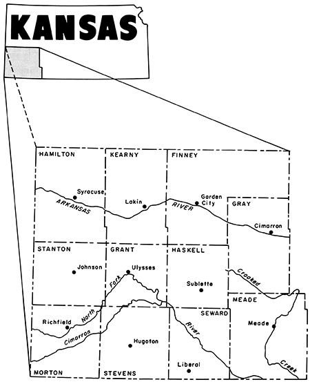
The study area (fig. 1) includes Finney, Grant, Gray, Hamilton, Haskell, Kearny, Meade, Morton, Seward, Stanton, and Stevens Counties in southwestern Kansas. The total area is about 8,900 square miles (Institute for Social and Environmental Studies, 1971).
Figure 1--Location of report area.
Previous Investigations
There are many studies dealing with geology and water resources in the study area. Early studies from 1897 to 1940 are listed by Smith (1940).
The historical data for this report were obtained from studies of the ground-water resources that began in 1937 in cooperation with the Kansas Geological Survey. These studies were reported as follows: Finney and Gray Counties by Latta (1944); Grant, Haskell, and Stevens Counties by McLaughlin (1946); Hamilton and Kearny Counties by McLaughlin (1943); Meade County by Frye (1942); Morton County by McLaughlin (1942); Seward County by Bryne and McLaughlin (1948); and Stanton County by Latta (1941).
Additional cooperative studies were made in southwestern Kansas after irrigation development. These studies were made as follows: Finney County by Meyer and others (1970) and by Gutentag and others (1972); Grant and Stanton Counties by Fader and others (1964); Gray County by McGovern and Long (1974); Hamilton County by Lobmeyer and Sauer (1974); Haskell County by Gutentag and Stullken (1974); and Kearny County by Gutentag and others (1972).
Well-Numbering System
The well numbers in this report give the location of wells and test holes according to the Bureau of Land Management's system of land subdivision. This method of well and test-hole location is shown in figure 2. The first number indicates the township; the second number indicates the range west of the sixth principal meridian; and the third indicates the section in which the well or test hole is situated. Letters following the section number locate the well within the section. The first letter denotes the quarter section or 160-acre tract; the second letter, the quarter-quarter section or 40-acre tract; the third letter, the quarter-quarter-quarter section or 10-acre tract.
Figure 2--System of numbering wells and test holes in Kansas.
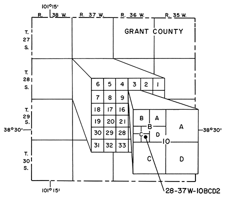
These tracts are designated A, B, C, and D in a counterclockwise direction beginning in the northeast quadrant. Where two or more wells are located in a 10-acre tract, wells are numbered serially, beginning with 2, according to the order in which they were recorded. For example, 28-37W-10BCD2 indicates that this is the second well or test hole recorded in the SE SW NW sec. 10, T.28 S., R.37 W., Grant County.
Metric Units
The inch-pound units of measurement given in this report are listed with equivalent International System (SI) of Units using the following abbreviations and conversion factors:
| Inch-pound unit | Multiply by | SI unit |
|---|---|---|
| Inch (in) | 2.54 | Centimeter (cm) |
| Foot (ft) | 0.3048 | Meter (m) |
| Mile (mi) | 1.609 | Kilometer (km) |
| Square foot (ft2) | 0.0929 | Square meter (m2) |
| Acre | 0.4047 | Square hectometer (hm2) |
| Square mile (mi2) | 2.590 | Square kilometer (km2) |
| Gallon (gal) | 3.785 | Liter (L) |
| Cubic foot (ft3) | 0.02832 | Cubic meter (m3) |
| Acre-foot (acre-ft) | 0.001233 | Cubic hectometer (hm3) |
| Gallon per minute (gal/min) | 0.06309 | Liter per second (L/s) |
| Cubic foot per second (ft3/s) | 0.02832 | Cubic meter per second (m3/s) |
| Foot per day (ft/d) | 0.3048 | Meter per day (m/d) |
| Gallon per minute per foot [(gal/min)/ft] | 0.207 | Liter per second per meter [(L/s)/m] |
| Foot per mile (ft/mi) | 0.1894 | Meter per kilometer (m/km) |
Acknowledgments
The authors wish to thank the land owners and farm operators for their cooperation, especially those who permitted the use of their wells or allowed test drilling on their property. Acknowledgment is given to Howard Corrigan, Water Commissioner, Division of Water Resources, Kansas State Board of Agriculture, for his help in this study. Acknowledgment also is given to the District Conservationists of the Soil Conservation Service and the County Executive Directors of the Agricultural Stabilization and Conservation Service who helped in the location of wells and irrigated acreage.
Prev Page--Contents || Next Page--Geologic framework
Kansas Geological Survey, Geohydrology
Placed on web July 28, 2013; originally published 1981.
Comments to webadmin@kgs.ku.edu
The URL for this page is http://www.kgs.ku.edu/Publications/Bulletins/IRR7/02_intro.html