![]()
Prev Page--Geologic Structure || Next Page--Chemical Quality
Hydrogeology
The lower Paleozoic aquifer system is considered in this report to consist of two carbonate aquifers separated over much of the area by a confining layer. The upper aquifer is composed of undifferentiated Mississippian carbonates, whereas the lower aquifer consists of rocks of the Cambrian-Ordovician System. Rocks of the Precambrian and Pennsylvanian systems are considered to be confining layers. However, in some parts of the study area shallow wells do obtain ground water from low-yielding sandstone and limestone aquifers in the Pennsylvanian. The U.S. Geological Survey has, for the Central Midwest Regional Aquifer Systems-Analysis Study, subdivided the lower Paleozoic rocks into geohydrologic units that differ from the designations used in this study (Bob Leonard, personal communication, 1984). Ground water occurs in these lower Paleozoic aquifers under confined artesian conditions except where the Mississippian is exposed at the surface.
A confined aquifer is a water-bearing, permeable geologic unit capable of transmitting significant quantities of water under ordinary hydraulic gradients, which is overlain by a geologic unit that may be saturated with water but is less permeable (Freeze and Cherry, 1979). Artesian conditions exist when the static water level of wells penetrating a confined aquifer is above the top level of the aquifer.
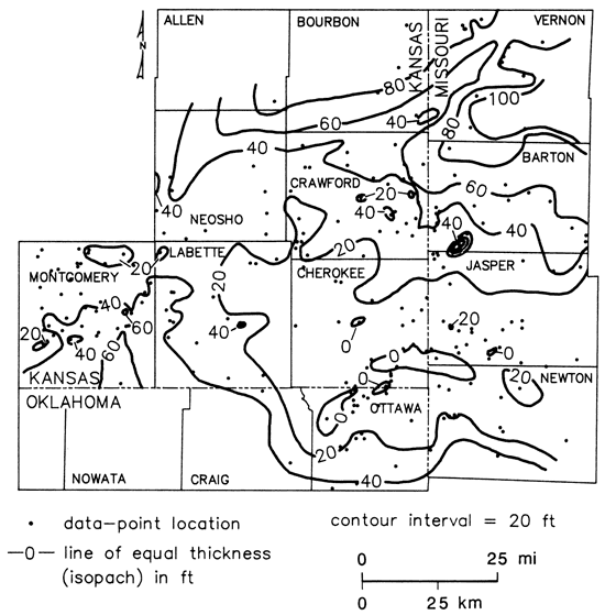
One or more stratigraphic units act as confining layers separating the Mississippian and Cambrian-Ordovician aquifers over most of the study area. These layers are composed of shale and fine-grained, dense limestone and dolomite belonging to the Chattanooga Shale, the Compton Dolomite, and the Northview Formation. Fig. 4 shows the variation in thickness of the confining layer across the study area. No field estimates of vertical permeability are available for the confining unit to assess leakage; however, Emmett and others (1979) assigned a vertical permeability of 10-9 ft/sec to the Northview Formation in the Springfield, Missouri, area. Where the confining layers are not present, the two aquifers might behave as one system although little data are available to confirm this hypothesis.
Figure 4--Isopach map of stratigraphic interval that includes Northview Shale, Compton Limestone, and Chattanooga Shale in Tri-State region.
Ground-water flow in most of the study area is in response to hydraulic gradients according to Darcy's Law. The fracture systems and solution channels introduce considerable heterogeneity into the aquifer system limiting the use of Darcy's Law on a local scale. This limitation can be partly ignored if the Darcian approach is used on a regional scale. The direction of water flow in the freshwater portion of the aquifer is from points of greater to lesser hydraulic head. Temperature, density, and hydraulic-head gradients influence the flow of ground water in the more saline portions of the aquifer. The lateral direction of water flow in the less saline portions of the aquifer can be found by constructing a potentiometric surface map in the region of interest. The configuration of the potentiometric surface is determined by contouring a map of measured, static water levels in wells that are open to the aquifer. The direction of water flow is then perpendicular to contours in the down-gradient direction. The authors have assumed that the aquifers are mostly isotropic since no data indicate the orientation of principal directions of anisotropy.
Aquifers in Mississippian rocks
Ground-water availability
The aquifer in Mississippian rock is used extensively for domestic supplies where the depth to the top of the aquifer is shallow and water quality is acceptable in southwest Missouri and northeast Oklahoma. The aquifer does not produce adequate amounts of water for most other purposes. Farther west in southeast Kansas and parts of northeast Oklahoma, ground-water chemical-quality changes make this aquifer unsuitable for domestic use.
Driller's logs of wells in the area indicate several water-bearing zones in the Mississippian. Ground water is stored in and transmitted by fractures and solution channels in the carbonate rock, especially where pre-Pennsylvanian erosion has developed a karstic surface in the rock at the top of the aquifer or where the aquifer contains brecciated chert or collapse features. Where the carbonate rocks are unfractured and dense, well yields are likely to be low. The maximum well yields can be expected to be 100 gal/min or more where the aquifer is more open. Typical well yields are likely to be approximately 25 gal/min.
Ground-water flow, recharge, and discharge
An insufficient number of water wells penetrating the Mississippian were studied to develop a reasonably detailed potentiometric surface map for the Mississippian aquifer in the study area. However, from the data available, the potentiometric surface is believed to slope generally westward from recharge areas where the aquifer is unconfined. Most of the recharge to the aquifer comes from precipitation falling on the land surface and entering solution-enlarged fractures and bedding-plane openings where the Mississippian is exposed at the surface (Feder, 1969). The aquifer also is recharged by surface water entering unplugged drill holes and mine shafts in the Tri-State mining area. Feder (1969) presents some hydrographs of water levels in abandoned mines in the Joplin, Missouri, area which show that water levels in the mines respond rapidly to precipitation events. Historically, the dewatering of lead-zinc mines in the Picher field along the Kansas-Oklahoma border created a large cone of depression in the Mississippian aquifer and changed the local direction of groundwater flow in Ottawa County, Oklahoma (Reed and others, 1955).
With the cessation of mining, the potentiometric surface is recovering in the Picher field. Streams in northern Ottawa County, Oklahoma, are receiving discharge from the aquifer and mines (Spruill, 1984). Outside the mining areas, ground water from the unconfined Mississippian aquifer normally supplies the base flow to many of the streams. Feder (1969) estimated that the undifferentiated Mississippian aquifer discharges an average of approximately 300 ft3/sec (135,000 gal/min) to streams in the Joplin area. Reed and others (1955) estimated that the total annual ground-water discharge from the aquifer in Ottawa County, Oklahoma, was 10,220 Mgal/yr (43 ft3/sec). Most of the regional discharge from the Mississippian aquifer in the study area is to the west into the deeper parts of the Cherokee basin.
Aquifers in Cambrian-Ordovician rocks
Well construction and water availability
Public water supply and industrial water wells in the Tri-State region are usually constructed in one of two ways. In most wells the casing extends from ground surface through the Mississippian and into the Cambrian-Ordovician; below the casing the well is an uncased bore hole to the total depth of the well. In the other method, portions of the Mississippian are not cased out. Thirty-two wells with this latter type of construction were inventoried during this study. In one well at Capaldo, Kansas, the open bore-hole portion intercepts aquifers in the Pennsylvanian, Mississippian, and Cambrian-Ordovician rocks. Typically, well depths range between 900 and 1,500 ft (270-450 m) for both types of wells and depend upon desired yield and changes in ground-water chemical quality noted with increasing depth in the aquifer.
The occurrence of ground water is directly related to the development of secondary porosity and permeability in the rocks. Secondary porosity and permeability are enhanced where there are solution-enlarged interconnected fractures and cavities. As a result, the relative amount of water produced by each zone in the Cambrian-Ordovician for a given well is difficult to predict. It should not be concluded that certain horizons within this aquifer will always produce more water than others. Porous zones can be readily identified on the sonic neutron-formation density and caliper logs and in well cuttings of several wells. Typical well yields of municipal and industrial wells range from 250 to 750 gal/min (33-100 ft3/min). Water is generally produced at a rate of approximately 100 gal/min (13.4 ft3/min) from most rural water-district wells. In areas where well yields are relatively low, the yield often can be increased somewhat by acid treatment of the well.
Ground-water flow, recharge, and discharge
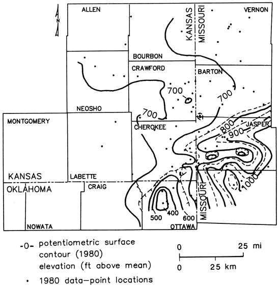
Ground-water flow in these aquifers is generally westward across the region from recharge areas in the Ozarks of southern Missouri to discharge areas west and south in Kansas and Oklahoma (fig. 5). The main source of recharge is precipitation entering the rocks where they are exposed at the surface in the Ozark region of southern Missouri. The potentiometric-surface map was drawn using 1980 static water-level measurements and other relatively recent static water-level data from other sources. Additionally, static water levels from wells open to the Mississippian and the Cambrian-Ordovician were included to supplement the data because head differences between the units seem to be small where these measurements were used. The contours on the potentiometric-surface map were closely spaced in southwest Missouri and eastern Cherokee County, Kansas, indicating relatively steep hydraulic gradients in the Cambrian-Ordovician, whereas to the west, the gradient decreases. The smaller gradients indicate increased permeability and relatively stagnant flow conditions in the aquifer in the chemical-quality transition zone. Also, a rather well-defined ground-water divide extends from Jasper County, Missouri, into Cherokee County, Kansas, between two pumpage centers in the Miami, Oklahoma, and Pittsburg, Kansas, areas. Large cones of depression have been created in these areas where wells have been pumping ground water from the deep aquifer since before 1900.
Figure 5--Composite potentiometric surface map of lower Paleozoic aquifers in Tri-State region.
Properties of Cambrian-Ordovician aquifer
Transmissivity and storativity are two properties that determine the ability of a confined aquifer to transmit and to store water (Freeze and Cherry, 1979). Transmissivity is defined as the product of the hydraulic conductivity and the aquifer thickness and indicates the capacity of a confined aquifer as a whole to transmit water. The storativity of a confined aquifer is defined as the volume of water an aquifer releases from or takes into storage per unit-surface area of aquifer per unit decline in the component of hydraulic head normal to that surface.
Few complete pump tests have been conducted in the Tri-State region to estimate transmissivity and storativity. Several drawdown and recovery pump tests were conducted in the 1940's at Miami, Oklahoma, on water-supply wells owned by B. F. Goodrich Rubber Company. The average transmissivity and storativity values determined from these tests were 38,100 gpd/ft (5,100 ft2/day) and 8.00 x 10⁻⁵ respectively (Reed and others, 1955). Pump tests also were conducted on the city wells at Pittsburg, Kansas (Stramel, 1957). These wells were open to aquifers in both Mississippian and Cambrian-Ordovician rocks. The average transmissivity and storativity values computed from these tests were 252,000 gpd/ft (33,800 ft2/day) and 7.8 x 10⁻⁴, respectively. Feder and others (1969) reported that values computed from a 24-hr interference test at Webb City, Missouri, were 4,000 gpd/ft (540 ft2/day) for transmissivity and storativity, 2 x 10⁻⁴.
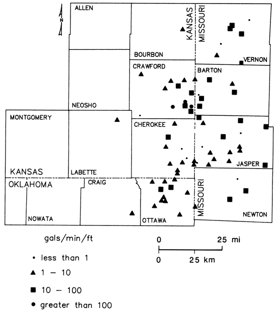
Some estimate of an aquifer's ability to transmit water can be developed from production tests on wells. During these tests both drawdown and discharge are measured in the pumping well. The test results are usually reported as the specific capacity (gpm/ft of drawdown). These tests, usually of short duration, may yield unreliable estimates of transmissivity if the test-pumping period is not sufficiently long, the well does not fully penetrate the aquifer, or if hydrogeologic boundaries exist nearby. In general, however, the specific capacity is directly related to transmissivity (Walton, 1970).
Fig. 6 shows the distribution of well specific capacities across the region. Specific capacities are generally less than 10 gpm/ft in Cherokee County, Kansas, and in Jasper and Newton counties, Missouri. To the north the specific capacities of wells are much higher and range from 10 to greater than 100 gpm/ft. The lower values of specific capacity (less than 10 gpm/ft) in Cherokee County, Kansas, and Jasper County, Missouri, coincide with steeper hydraulic gradients in the aquifer. These findings indicate that aquifers in Cambrian-Ordovician rocks are less permeable in this part of the study area than in other parts. The highest specific capacities in the area found near Pittsburg, Kansas, correspond to the highest values of transmissivity in the region.
Figure 6-Specific-capacity variation reported for wells completed in Lower Paleozoic aquifers in Tri-State region.
Hydraulic connection between aquifers
Leakage of ground water downward from aquifers in the Mississippian rocks to the Cambrian-Ordovician is possible where the Northview and Chattanooga shales are thin or absent and where greater hydraulic head exists in the Mississippian aquifer than in the Cambrian-Ordovician aquifer (Reed and others, 1955; Feder and others, 1969). Fractures further enhance the possibility of downward leakage in these aquifers. Interconnection of aquifers does occur in 32 wells in the study area where the open bore-hole portion of the well includes Mississippian and Cambrian-Ordovician rocks. Hydraulic-head data from Spruill (1984) for the Mississippian in the Joplin, Missouri, and Miami, Oklahoma, areas indicate that substantial hydraulic-head differences exist between the Mississippian and Cambrian-Ordovician aquifers in these areas. Some recharge may be occurring in western Jasper County, Missouri, where the static water levels of two water wells have apparently risen since they were drilled. Additionally, geochemical evidence from this study and Feder and others (1969) indicate that aquifers in the Cambrian-Ordovician rocks are receiving significant amounts of recharge from the overlying Mississippian in southwest Missouri and northeast Oklahoma. This is discussed further in the ground-water chemical-quality section of this report.
Effects of well development
The ground-water resources of the Cambrian-Ordovician aquifers in the Tri-State region have been used extensively in the area for water supply since the early 1900's. One result of this development has been a lowering of the static water levels in wells completed in the aquifer systems throughout the area (Reed and others, 1955; Stramel, 1957). Where the rate of water withdrawal from the Cambrian-Ordovician aquifer has been relatively low, the decline in static water level is generally less than 50 ft (15 m). Static water-level declines in excess of 450 ft (135 m) have occurred in the area north of Miami, Oklahoma, and declines of 150 ft (45 m) have occurred southeast of Pittsburg, Kansas, and in northwestern Jasper County, Missouri. In these areas the rate of ground-water withdrawal has been substantial (approximately 4 Mgal/d in the Miami, Oklahoma, area in 1980) since the early 1900's. The static water-level declines in wells in the Joplin area have not been as extensive because sufficient recharge from the Mississippian may be able to partially overcome the effects of ground-water withdrawals from the Cambrian-Ordovician, and the total amount of water withdrawn from the aquifer by wells has been small relative to other parts of the Tri-State region.
Prev Page--Geologic Structure || Next Page--Chemical Quality
Kansas Geological Survey, Geohydrology
Placed on web Sept. 1, 2010; originally published 1987.
Comments to webadmin@kgs.ku.edu
The URL for this page is http://www.kgs.ku.edu/Publications/Bulletins/GW9/05_hydr.html