![]()
Prev Page--Introduction || Next Page--Lost Branch Formation
Origin and evolution of previous nomenclature
Earliest work
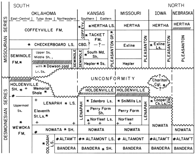
The names Wewoka Formation, Holdenville Shale, and Seminole Formation (fig. 3) were originally applied in ascending order by Taff (1901) to a thick sequence of shale and sandstone with conglomerate and thin limestone beds in what is now recognized as a Middle-Upper Pennsylvanian basinal facies in the east-central Oklahoma counties of Hughes and Seminole (for geographic localities, refer to fig. 7). The names Nowata Shale, Lenapah Limestone, and Curl (now Coffeyville) Formation were originally applied in ascending order by Ohern (1910) to a shale-limestone-shale-with-sandstone sequence in what is now recognized as the equivalent shelf facies 120 mi (193 km) northward, in Nowata County, northeastern Oklahoma. Ohern (1918) later erroneously correlated the Lenapah Limestone with the Dawson coal of the Tulsa region to the south, a region now recognized as near the shelf edge along the north side of the basin. Thus the Nowata Shale was regarded as extending upward to the base of the Dawson coal around Tulsa.
Figure 3--Previous nomenclature and correlation of Desmoinesian-Missourian boundary interval from Bandera Shale to Hertha Limestone along the midcontinent outcrop belt [compiled from references discussed in text and from Fay et al. (1979) for Oklahoma]. Asterisks (*) denote geographic locations of type sections of each named unit. Formation and group names are printed in capital letters; member and other names are printed in lowercase letters. Hatch marks (///) show previously correlated positions of strata now recognized as correlative with the uppermost Desmoinesian marine horizon described in the text on the basis of distinctive conodont fauna (Swade, 1985; my work) and ammonoid fauna (Boardman and Mapes, 1984). Plus signs (+) denote previous correlated positions of strata correlative with the lower Lenapah Limestone (Norfleet Limestone Member) based on distinctive conodont fauna (Parkinson, 1982; Greenberg, 1986; my work). Scratch marks (#) denote previous positions of strata correlative with the Altamont Limestone based on distinctive conodont fauna (Swade, 1985; my work) and ammonoid fauna (D. R. Boardman, personal communication, 1984). Hatch marks drawn in the Hertha Limestone in Nebraska are based on conodont analysis of shale within the limestone in the Amerada core (NAC) that was correlated with the Hertha by Condra (1939) and to my knowledge has not been revised since.
Revised correlations
Later work [reported by Dott (1941)] determined that the stratigraphically lower, informally named Eleventh Street limestone of the Tulsa region, rather than the Dawson coal, is equivalent to the Lenapah Limestone. Then, when Moore et al. (1937) delimited the base of the Coffeyville Formation at the Checkerboard Limestone [named from Okmulgee County just to the south; see Oakes (1940, p. 27)] and extended the Seminole Formation below it northward into the Tulsa region as the lowest Missourian formation in that area, they also included the Dawson coal in the middle shaly part of the Seminole (fig. 3). This revision of correlation caused D. J. Jones to change the unit names in his long-term study of the conodont fauna of the black shale that overlies the Dawson coal at Collinsville, 20 mi (32 km) northeast of Tulsa, from "Nowata Shale" in his Master's thesis (1935) to "Seminole Formation" in his doctoral dissertation (1941).
Dott (1941) applied the name Memorial Shale to a sequence previously regarded as part of the Nowata Shale. This sequence extends upward from the Eleventh Street limestone to the base of the lower sandstone of the Seminole Formation, which lies below the Dawson coal. Along with Moore et al. (1937), Dott (1941) indicated that the Memorial Shale is Desmoinesian in age, equivalent to the upper part of the Holdenville Shale to the south, and that the regionally unconformable contact supposedly existing between the Memorial Shale and the overlying Seminole Formation is the Desmoinesian-Missourian boundary. Oakes and Jewett (1943) discussed and illustrated the nature of this unconformable contact in the two counties (Nowata and Labette) on either side of the Kansas-Oklahoma border. Their placement of the contact depended on the assumption that the Dawson coal was Missourian and that the brachiopod Mesolobus was a Desmoinesian index fossil. These assumptions effectively classified any coal lying upon the Lenapah Limestone and above which no Mesolobus was found (as in most of Nowata County, Oklahoma) as Missourian Dawson coal and any coal lying upon the Lenapah Limestone but above which Mesolobus was found (as around Mound Valley in Labette County, Kansas) as Desmoinesian and thus not Dawson coal (Oakes and Jewett, 1943, fig. 1).
Oakes (1952, p. 41) decided that in Tulsa County and southward the Lenapah (Eleventh Street) Limestone is equivalent to the uppermost sandstone beds of the Wewoka Formation (fig. 3). On the basis of this assumed correlation, the Memorial Shale, which extended from the top of the Lenapah to the base of the Seminole Formation, would occupy the same stratigraphic interval as the earlier named Holdenville Shale to the south, and thus the prior name, Holdenville, should take precedence. This change was subsequently accepted by the Missouri and Kansas geological surveys [e.g., Howe (1953), Searight and Howe (1961), and Zeller (1968)], which now utilize the name Holdenville Shale or Formation for the shale interval between the top of the Lenapah and the Desmoinesian-Missourian unconformity (fig. 3). This boundary is marked by a basal Missourian sandstone along much of the outcrop in Kansas and Missouri.
Hepler sandstone
Based on a type section in southern Bourbon County, Kansas, Jewett (1940) originally applied the name Hepler to the basal Missourian sandstone that he assumed was a persistent key marker horizon for surface mapping. (Current problems with this assumption involve recognition of sandstones at three distinctly different stratigraphic horizons, all of which had been identified as Hepler sandstone in the older literature, a point that is discussed later.) The Hepler sandstone was considered to overlie the Memorial (=Holdenville) Shale in Kansas and to form the base of the Bourbon group (now called the Pleasanton Group) (fig. 3). Although Jewett (1940) thought that the Hepler was equivalent to the lower part of the Seminole Formation in Oklahoma, Oakes and Jewett (1943) stated that it is equivalent to only the upper part, because the middle part of the Seminole, which contains the Dawson coal, supposedly had overlapped the lower part northward from Tulsa. More recently, Jewett et al. (1965) classified the Hepler sandstone as the lower member of the Seminole Formation in Kansas and proposed the name South Mound for the overlying shale member of the Seminole, which is overlain by the Checkerboard Limestone, the same unit that caps the Seminole in Oklahoma (fig. 3).
Lenapah Limestone
Jewett (1941, 1945) subdivided the Lenapah Limestone in Kansas into three members, all named from central or western Labette County. In ascending order they are the Norfleet Limestone Member, the Perry Farm Shale Member, and the Idenbro Limestone Member (fig. 3). Jewett (1941, p. 337) recognized the Idenbro as the limestone bed at the top of the type Lenapah Limestone in northern Oklahoma and concluded (Jewett, 1945) that the Perry Farm, which contains limestone nodules in Kansas, grades southward into the nodular limestone that constitutes the main part of the type Lenapah, with only a thin green shale at the top representing the shale facies. Jewett (1941, 1945) recognized the Norfleet Limestone Member as discontinuous and thin, except where it forms the sandy base of the lower limestone ledge just south of the Lenapah type section in Oklahoma (Jewett, 1945, plate 4). Oakes (1952) neither recognized nor traced these members of the Lenapah Limestone as separate lithic units southward to Tulsa.
The tripartite subdivision of the Lenapah Limestone was soon recognized in Missouri [see Howe (1953, p. 10)], but the name Idenbro was dropped in favor of Sni Mills Limestone Member, named by F. C. Greene [in Moore et al. (1936)] from the Kansas City area, because Cline and Greene (1950) believed that the two limestones were equivalent (fig. 3). Howe (1953) noted that the base of the Holdenville Shale just above the Sni Mills is a black fissile phosphatic shale in many places, that it extends laterally beyond the pinch-out of the Sni Mills, and that it had been called the "Dawson coal horizon" by earlier workers.
After correlations by Weller et al. (1942) and despite mild reservations expressed by Cline and Greene (1950), the Iowa Geological Survey recognized the Cooper Creek Limestone, named by Cline (1941, p. 65) from Appanoose County on the Missouri border, as the only member of the Lenapah Limestone in that state (Hershey et al., 1960). The Cooper Creek Limestone had been correlated with the Sni Mills Limestone Member of Missouri by Howe (1953) and also with the Lonsdale Limestone Member of Illinois by Weller et al. (1942). The Iowa Geological Survey did not recognize the Holdenville Shale, instead considering the Cooper Creek Limestone to be overlain by the Pleasanton Group of Missourian age (Hershey et al., 1960). In Iowa the Pleasanton lacks the Hepler sandstone but contains a thin limestone, named the Exline limestone by Cline (1941, p. 65) from Appanoose County, not far from the type Cooper Creek. Cline (1941, p. 70) suggested that the position of the Desmoinesian-Missourian series (now stage) boundary was marked by the "Chariton conglomerate," a lenticular unit that Cline (1941) thought lay above the Exline limestone but that Landis and Van Eck (1965) thought lay below the Exline (fig. 3). The Iowa Geological Survey has placed this series/stage boundary at the top of the Cooper Creek limestone (Hershey et al., 1960; Landis and Van Eck, 1965). Although Howe (1982, p. 34) believes that the "Chariton" overlies the Exline limestone member in Missouri, the stratigraphic relations of the "Chariton conglomerate" in its type area in Iowa remain uncertain (Ravn et al., 1984).
Neither the Lenapah Limestone nor the Holdenville Shale has been officially recognized in Nebraska (Condra, 1949), where the Missourian Pleasanton Group is considered to rest disconformably upon the Nowata Shale (fig. 3), with the uppermost Marmaton beds removed by erosion (Burchett, 1979).
New findings
Age of the Dawson coal
The old scheme of classification and correlation (fig. 3) began to come apart when Wilson (1972) noted that fossil plants in the Seminole Formation in Tulsa County have Desmoinesian affinities and when Pearson (1975) and Wilson (1979, 1984) reported that the Dawson coal in Tulsa County, its type area, contains Desmoinesian palynomorphs. Moreover, both Wilson (1979) and Bennison (1979, p. 289) reported that the Dawson coal is overlain in Tulsa County by shale that contains Mesolobus, the supposed absence of which had helped previous workers place the coal in the Missourian. Also in 1979, I collected conodonts from the black shale above the Dawson coal at Collinsville (just north of Tulsa) to corroborate the fauna reported by Jones (1935, 1941). This fauna closely resembles the Desmoinesian fauna found by Swade (1982, 1985) in a thin shale below the Cooper Creek Limestone in Iowa. Shortly thereafter, D. R. Boardman discovered ammonoids in the upper part of the type Holdenville Shale that are identical with those reported by Miller and Owen (1937) from the black shale above the Dawson coal at Collinsville (Boardman and Mapes, 1984). Although Miller and Owen (1937) had noted that the Collinsville ammonoids include many characteristic Desmoinesian forms, they regarded them as Missourian because the beds had been mapped as Missourian. The new findings now necessitate the removal of the Dawson coal and the overlying black shale from the Seminole Formation and the Missourian Stage (fig. 4). Detailed subsurface correlations by Krumme (1981) and extensive field mapping by Bennison (1981, 1984) southward into the basinal type areas of the Holdenville Shale and Seminole Formation have revealed enough uncertainty in definition and miscorrelations by previous workers between there and Tulsa to question the use of these names in the Tulsa area and northward until the northern equivalents can be adequately ascertained.
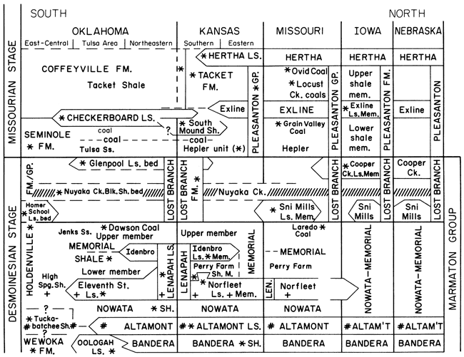
Figure 4--Revised correlation and new nomenclature of uppermost Desmoinesian and adjacent strata shown in fig. 3 along the midcontinent outcrop belt, based on lithic relations in outcrop exposures and cores and correlated by means of conodonts (Swade, 1985; Parkinson, 1982; Pavlicek, 1986; Greenberg, 1986; my work), ammonoids (Boardman and Mapes, 1984; D. R. Boardman, personal communications, 1982-1986), and palynomorphs (R. A. Peppers, personal communications, 1981-1984). As in fig. 3, hatch marks (///) show the correlation of the Lost Branch horizon, plus signs (+) show the correlation of the lower Lenapah horizon, scratch marks (#) show the correlation of the Altamont horizon, and asterisks (*) show the geographic location of the type sections of all named units. Formation and group names are printed in capital letters; member and other names are printed in lowercase letters. Bandera Shale-Oologah Limestone relations were worked out by Price (1984). The nomenclature of Missourian strata is still in flux. Krumme (1981, p. 20-32) and Bennison (1984, p. 120-122) summarized problems of miscorrelation of the Seminole Formation and Checkerboard Limestone in Oklahoma. An understanding of Hertha Limestone-Tacket Formation-Pleasanton Group relations has evolved through the work of Ravn (1981), Bennison (1984, pp. 122-123), Underwood (1984), and Pavlicek (1986) and is currently being summarized by Heckel (unpublished). Pleasanton nomenclature in Iowa is based on Ravn et al. (1984), and in Missouri it is currently under revision by W. B. Howe.
Relations of the Lenapah Limestone
Bennison's field mapping north of Tulsa revealed that the Lenapah Limestone is traceable south of Lenapah as two distinct limestone beds diverging from one another, and he rediscovered the observation of Moore et al. (1937, p. 41) that the upper limestone at the Lenapah type section is overlain by the Dawson coal and its overlying black shale. Recognition of this relation strongly aided Parkinson's (1982) study of the Lenapah Limestone in its type area, which turned up a distinctive Neognathodus-dominated conodont fauna [plus signs (+) in figs. 3 and 4] at the base of the lower limestone bed, a fauna that was not detected by Swade (1982) in the Iowa cores. Greenberg (1986) and I have since recovered this fauna from the entire thickness of the Eleventh Street limestone in the Tulsa region, from the type Norfleet Limestone Member of Labette County, Kansas, and from numerous places in eastern Kansas and western to north-central Missouri in limestones that Howe (1953) had correlated mostly with the Norfleet. Greenberg (1986) noted that this fauna is replaced progressively by a nearshore Adetognathus-dominated fauna in the Norfleet Member in north-central Missouri.
Thus the Eleventh Street limestone is equivalent to only the Norfleet Limestone Member at the base of the type Lenapah Limestone (fig. 4) rather than to the entire Lenapah Limestone, as assumed by previous workers (fig. 3). Furthermore, because the lower Seminole sandstone, which defines the top of the original Memorial Shale, extends northward only through T. 23 N. (Oakes, 1952, p. 54) just south of Talala in northeastern Oklahoma (see fig. 8) and because A. P. Bennison has traced the upper Lenapah Limestone (Idenbro Member), which always lies a few feet below the Dawson coal, from the Lenapah type section southward to Talala, it follows that the type Memorial Shale of Dott (1941) is largely equivalent to the Perry Farm Shale Member in the middle of the Lenapah, which Parkinson (1982) found to thicken southward near Nowata. Consequently, the type Holdenville Shale is equivalent to at least the middle and upper Lenapah Limestone in addition to what had been called the Holdenville Shale to the north, and Krumme (1981) suggested that it might include most of the Nowata Shale as well. In this light, the Memorial Shale can be viewed as a valid subdivision of the Holdenville Shale, rather than as a junior synonym.
Moreover, D. R. Boardman's latest ammonoid information and my latest conodont information strongly suggest that the lowest marine horizon currently assigned to the Holdenville Shale in its type region, informally named Tuckabatchee shale by Bennison (1984), actually correlates with the Altamont Limestone below the Nowata Shale and one marine cycle below the Lenapah Limestone (fig. 4). If this is the case, then the type Holdenville Shale is equivalent to the entire upper (post-Bandera Shale) part of the Marmaton Group of the northern shelf. Nevertheless, uncertainty still exists as to whether the Tuckabatchee shale properly belongs in the Holdenville, where it was mapped by Weaver (1954) in northern Hughes County, or in the Wewoka Formation, where its supposed southern extent was mapped by Taff (1901) in southern Hughes County. Either alternative reinforces the case that the name Holdenville Shale (Formation) as currently utilized by the Kansas and Missouri geological surveys (fig. 3), should be abandoned because it is equivalent to only the top of the type Holdenville Shale in Oklahoma.
Recorrelation of northern "Lenapah" limestones
Parkinson (1982) also found in the black shale above the Dawson coal, where it lies above the upper Lenapah Limestone, the same conodont fauna that Jones (1935, 1941) found at Collinsville and later that I found both at Collinsville and in samples from the upper part of the type Holdenville Shale that D. R. Boardman sent to me. Swade (1982, 1985) found this fauna below the Cooper Creek Limestone in Iowa, and I collected it from the dark phosphatic shale in the base of the "Holdenville Formation" in west-central Missouri, where it directly overlies the Sni Mills Limestone Member in its type area (fig. 3). The occurrences of this distinctive conodont fauna [hatch marks (///) in figs. 3 and 4] point to several conclusions: (1) This offshore-marine, conodont-rich, black to gray, phosphatic, shale-dominated horizon seems to be continuous along the midcontinent outcrop. (2) This horizon overlies the type Lenapah Limestone but is separated from it by the terrestrial Dawson coal and its underclay. (3) Therefore this marine horizon and its northern associated marine strata, the Sni Mills Limestone Member and the Cooper Creek Limestone, formed during a marine inundation that was younger and more widespread than that forming the Lenapah Limestone, and this inundation followed a marine withdrawal to at least the southern extent of the Dawson coal some distance south of Tulsa. [The importance of the lateral extent of the terrestrial horizon below the Sni Mills Member in Missouri was recognized earlier by Greene and Howe (1952) and Howe (1953).] (4) Consequently, the Sni Mills Member and Cooper Creek Limestone must be removed from the Lenapah Limestone (fig. 4).
Desirability of a new named formation
The higher marine horizon is significant because it contains the youngest known midcontinent occurrences of the conodont Neognathodus, the brachiopod Mesolobus, and several typically Desmoinesian ammonoid taxa (Boardman and Mapes, 1984). Moreover, it overlies the Dawson coal, which contains the youngest known occurrence of a typical Desmoinesian miospore flora rich in Lycospora (R. A. Peppers, personal communications, 1982, 1983). Thus the regional correlation of this interval is of paramount importance for the exact delineation of the Desmoinesian-Missourian boundary in the type area of both stages in the midcontinent outcrop belt. Because the names previously applied to different parts of this horizon are overly inclusive names (Holdenville Shale), miscorrelations (Seminole Formation, Lenapah Limestone), or just local facies [Cooper Creek Limestone, Sni Mills Limestone Member; also Homer School limestone bed, Nuyaka Creek black shale bed, and Glenpool limestone bed of Bennison (1981, 1984)], I propose to name the entire marine horizon as a new formation (fig. 4).
Prev Page--Introduction || Next Page--Lost Branch Formation
Kansas Geological Survey, Geology
Placed on web Nov. 2, 2010; originally published 1991.
Comments to webadmin@kgs.ku.edu
The URL for this page is http://www.kgs.ku.edu/Publications/Bulletins/GS4/03_prev.html