![]()
Prev Page--Wells || Next Page--Issues, Conclusions
Ground-water management
Working out the water balance for a river basin, watershed, or aquifer that serves individual towns or cities with water is in some ways like checking the financial balance of a household--it helps us to see where the expenditures are going and whether we can afford to spend more or need to restrict expenditures. The water balance enables us to see whether more use can be made of the area's water resources. Because detailed information about water is often unavailable, it is difficult and time-consuming to prepare a detailed and accurate water budget for a watershed or an aquifer. However, enough information exists to prepare an approximate annual budget for the state as a whole as an example of the analysis that has to be done in more detail for local areas.
Although our interest here is in ground water, it is easier to construct our overall water balance in terms of water arriving at and leaving the land surface. The inputs of water (precipitation in the form of rainfall and snowfall, or streams and ground water flowing in from outside the state) may be considered credit items; amounts of water withdrawn or depleted (including the outflow of streams and ground water; evaporation from lakes, ponds, rivers, and moist soil; and transpiration from plants) represent debit items. Precipitation (the dominant input) averages approximately 115 million acre-ft (MAF) over Kansas annually (if water were placed 1 foot deep over the entire state, the volume required would total 52.55 MAF.). Of the output terms, the largest is evapotranspiration, which averages about 105 MAF per year from the state. The annual outflow of Kansas rivers that originate within the state amounts to approximately 9.9 MAF (for this analysis, flow that originates outside the state is simply subtracted from total outflow). This flow leaves the state and eventually reaches the Gulf of Mexico. Ground-water recharge quantities are not precisely known, but they are smaller than the uncertainties of the other budgetary terms, most probably less than 0.9 MAF per year. Much of this is returned to the streams as baseflow, which sustains the rivers throughout dry weather. If the recharge number were actually 0.9 MAF per year and all of it reached the ground water, this would correspond to about 0.8 billion gallons per day--a far smaller number than the average statewide withdrawal rate of 5.6 billion gallons per day, or 6.3 MAF per year. To pursue the financial analogy, our ground-water usage clearly exceeds present income and is cutting into capital; this is possible because of the large amount of ground water stored in the aquifers. The terms in this large-scale water budget are portrayed in Figure 25. When we focus specifically on analysis of ground-water systems, a very similar process is used, but different budgetary terms become important on the time scales of ground-water movement. Figure 26 gives a schematic example of an approach to ground-water balance calculations.
Figure 25--A water budget schematic as it might be applied to a specific region. Part A shows the natural condition; part B indicates the kind of changes that must be considered when extensive ground-water withdrawal occurs.
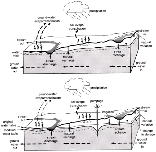
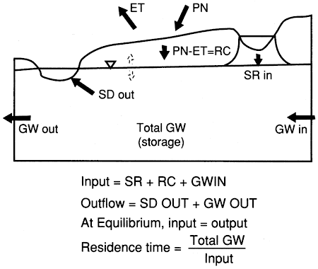
Figure 26--A large-scale schematic depiction of a water budget. ET = evapotranspiration, PN = precipitation, RC = recharge, SR = stream recharge, SD = stream discharge, GW = ground water.
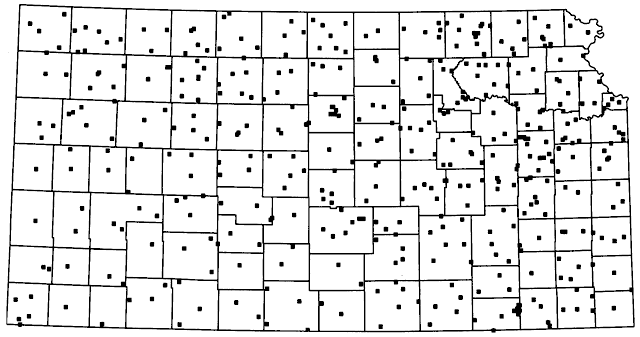
Although precipitation, evapotranspiration, and other factors in the water budget vary widely from year to year at any one location and from place to place within the state, the large-scale, long-term averages remain nearly constant. That permits us to construct the approximate state water budget with ease. Unfortunately, this is of little use in managing the day-to-day reality of local water supplies--we can't effectively move the rainfall of eastern Kansas to the west, or transplant the western aquifers to the east. For dealing with local issues we need local data--usually more of it and over a longer time period than actually exists. To meet these needs, a number of state and federal agencies maintain monitoring programs for critical hydrologic data. Figure 27 shows the distribution of wells in the Kansas ground-water-level monitoring network; the density of points corresponds reasonably well with the availability of ground water. That is, the more points on the map, the more ground water. Other key hydrologic variables are streamflow and climate, and the measurement stations for these are shown in Figures 28 and 29. Other programs monitor water quality, reservoir water levels, etc. This network of measurement may seem extensive, but it has been carefully designed to obtain the essential information with minimum cost and effort. Building the data base needed to understand and manage the hydrologic system is time-consuming and expensive--but not nearly as expensive as the consequences of ignorance.
Figure 27--Kansas ground-water monitoring network.
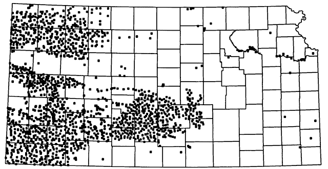
Figure 28--Streamflow-measurement stations in Kansas. For more information, visit the U.S. Geological Survey Kansas page. Map adapted from U.S.G.S.
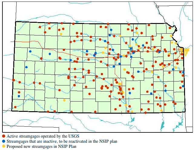
Figure 29--Climate-measurement stations in Kansas.
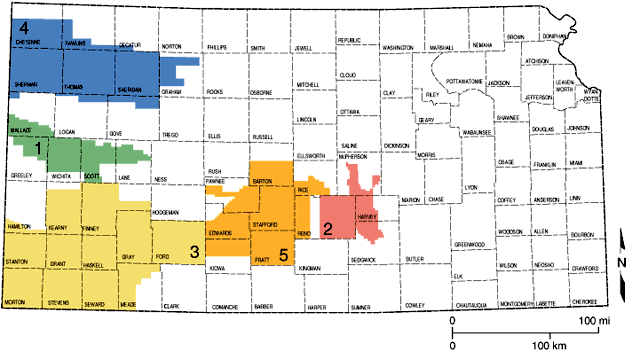
The basic tool for managing water resources on a statewide basis is the system of water rights appropriations administered by the Division of Water Resources (DWR) of the State Board of Agriculture (for an annotated list of water research and regulatory agencies and organizations, see Appendix C). Certain minimal uses of ground water, such as domestic and livestock wells, are exempt from water-rights regulation, but large-scale water users must apply for and be granted water rights--essentially, a permit to divert surface water or pump ground water in specified amounts. Local levels of management are provided in some areas by groundwater management districts; these bodies were created in the 1970s and are authorized under state law to provide more detailed levels of ground-water use administration and planning. Today, five groundwater management districts (GMDs) exist and are shown in Figure 30. All districts correspond to major portions of the High Plains aquifer system (GMDs 1, 3, and 4 overlie the Ogallala aquifer, GMD 5 corresponds to the Great Bend Prairie aquifer, and GMD 2 covers the Equus Beds aquifer and part of the alluvial aquifer of the lower Arkansas River). Primary ground-water uses in the groundwater management districts are irrigation, although the Wichita area obtains part of its municipal supply from the Equus Beds aquifer. These districts are governed by local boards and have been instrumental in providing information and identifying research and regulatory needs in their boundaries. Several of the districts, for example, have worked with the Division of Water Resources to identify intensive ground-water use control areas (or IGUCAs), locations where there have been substantial ground-water declines or water-quality problems. In those areas (which also have been declared for locations outside of groundwater management districts), limits are placed on the drilling of new wells or on pumping from existing wells. Groundwater management districts also have been involved with water-education programs and some districts have even carried out cloud-seeding programs designed to increase rainfall and suppress hail.
Figure 30--The state's five groundwater management districts.
Access to water was historically an issue long before the present level of hydrologic understanding was available, and Kansas, like most western states, adopted a seniority system to deal with uncertainties in water supply. "First in time, first in right" is the traditional slogan, meaning that when water supplies are not adequate to supply all of the water rights, priority is established according to the seniority of the rights. That is, older (or senior) water rights take priority over more recent (or junior) water rights. This rule is reasonably straightforward when applied to surface water, but the concept is harder to apply to ground water because ground-water-system response times are long compared to the time scales of local human perturbations, and we usually have only an approximate idea of the exact size or renewal rate of the resource. In other words, heavy pumping of one water right may limit pumping of another right, but that is difficult to prove and may take years to show up.
At present, state and local policies indicate that aquifers should be managed on a safe-yield basis, but this is a goal rather than an accomplished fact. Many major Kansas ground-water resources were over-allocated in terms of pumping rights before safe-yield policies were in place. State and local agencies and water users are grappling with the issues of how to deal with the situation. The problem is further complicated by the fact that our predecessors did not understand the degree to which streamflow and ground water are interconnected when separate systems of ground-water and surface-water rights were established. As we discussed earlier, permanent streamflow is usually the result of ground-water discharge, so that if ground-water pumping lowers the elevation of the water table below that of the stream bed, streamflow will be reduced or interrupted. On the other hand, streamflow may be the major source of recharge to some alluvial aquifers, so that streamflow regulation or diversion may alter the recharge characteristics, and therefore the safe yield of the ground water in the area. For example, in 1991 and 1992, the state's Division of Water Resources held hearings concerning streamflow in Wet Walnut Creek (which provides some of the water for Cheyenne Bottoms). The DWR eventually decided that streamflow was being lowered because of ground-water pumping for irrigation, created an IGUCA, and limited pumping on existing wells. This was an historic recognition of the relationship between streamflow and ground water.
Water-resource management also must consider other needs and values, among them water quality, flood control, wildlife habitat, and recreation. The conflicts between the multiple uses are well expressed by the observation that for flood control a reservoir should be empty, for water supply it should be full, and for recreation the level should remain constant. Ground-water issues come into play most strongly with respect to biological habitat concerns. Wetlands and marshes, like the baseflow of streams, are generally related to ground-water discharge. They are therefore vulnerable to water-table fluctuations as well as surface-water balance, and concerns about the major wetlands habitats of central Kansas (Cheyenne Bottoms and Quivira Marsh) have sparked interest in the water budgets of those areas.
Keep in mind, however, that the legal process, and not social or scientific policy, determines how water is allocated to different interests. Very often, cases boil down to senior water-rights versus junior water-rights. Older rights, quite simply, give their owner the priority for access to water when supplies are tight. In the case of Wet Walnut Creek, again, the rights to water flowing into the stream (and eventually to Cheyenne Bottoms) were older, or more senior, than rights for pumping ground water. Thus, the case was decided not on the desirability of maintaining streamflow for the sake of Cheyenne Bottoms, but on the legal issue of the age of the right to acquire water.
Water management is a complex and difficult process and will become more so as demands increase while available resources decrease. Fortunately, Kansans have taken a forward-looking step in creating the Kansas Water Plan. The Kansas Water Office (under the direction of the Kansas Water Authority) is responsible for centralized planning and coordination for all water-related issues, while leaving intact the specific responsibilities of existing state water agencies. Much of the water-resources planning for Kansas is currently accomplished on the basis of the state's twelve major drainage basins, a division based on the philosophy that areas drained by the same stream often have many similar water issues in common.
This current approach to water planning and regulation in Kansas attempts to avoid the problems inherent in dealing with an integrated system (the hydrologic cycle) on a piecemeal and patchwork basis, while still retaining local control and the advantages of specialized expertise. If successful in this effort, Kansas will be better positioned than most states to address the water problems of the future.
Prev Page--Wells || Next Page--Issues, Conclusions
Kansas Geological Survey, Kansas Ground Water
Comments to webadmin@kgs.ku.edu
Web version Jan. 2005. Original publication date August 1993.
URL=http://www.kgs.ku.edu/Publications/Bulletins/ED10/07_manage.html