![]()
Prev Page--Use || Next Page--Quality
Ground-water occurrence
General
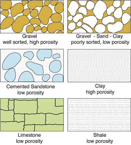
Nearly all rocks and sediments contain openings called pores or voids, which come in all shapes and sizes. Some of them are too small to be seen with the unaided eye, and the smallest range in size down to the dimensions of molecules. In exceptional cases, they may be many feet across, like the limestone caverns in the Ozarks. The fraction of total volume occupied by pores or voids is called porosity. Materials containing a relatively large proportion of void space are described as porous or said to possess "high porosity." That fraction of the pores through which water can flow is called effective porosity. Total porosity may range from near zero to over 50%, depending on the material, while effective porosities are typically somewhat smaller. Figure 2 shows examples of different types of porosity.
Figure 2--Different rock types have different levels of porosity.
Soil also is porous. On hot summer days, the surface soil may appear quite dry, but if we dig down a little way the soil feels damp; if we could dig far enough to reach rock, this too would feel damp. This is because the pores are not empty; some are filled, or partly filled, with water. In general the smaller pores are more likely to contain water and the larger ones are more nearly empty. At a still greater depth, we would find that all the pores are completely filled with water, and we would then describe the rock or soil as "saturated." In scientific terms, we would have passed from the surface through the vadose or unsaturated zone to the saturated zone.
If we dig or drill a hole from the ground surface down into the saturated zone, water will flow from the surrounding material into our hole until it reaches a constant level. This is the depth at which all of the pores are filled with water--in other words, the upper limit of the saturated zone. We call this level the water table. The thickness of the layer of rock or loose sediment that is saturated with water is called the saturated thickness.
The distance we need to drill or dig to reach the water table varies from place to place; it may be less than 3 feet (1 m), or more than 300 feet (90 m). It may even coincide with the ground surface. If so, the ground will be wet and marshy, or there will be a pond, spring, or river. Where the water table is below the ground, as is usual, its depth can be measured in a well.
Once we drill to the water table, several factors control how much water we can extract from the saturated zone. One is the porosity. If it is small (a few percent or less), then the amount of water contained in a given volume of rock will be small. The second factor is the ease with which fluids can move through the porous rock or loose sediment. It is directly related to a combination of the size of the pores and the degree to which the pores are interconnected. We call this second factor permeability or hydraulic conductivity. Materials that allow water to pass through them easily are said to be permeable; those that permit water to pass only with difficulty or not at all are impermeable. A rock may be porous but relatively impermeable, either because the pores are not connected or because they are so small that water can be forced through them only with difficulty. Conversely, a rock that has no voids except for one or two open cracks will have a low porosity and will be a poor storer of water, but because water will be able to pass easily through the cracks, the permeability will be high. Layers of rock sufficiently porous to store water and permeable enough to allow water to flow through them at useful rates are called aquifers. Related terms are applied to low-permeability layers (aquitards) and impermeable zones (aquicludes). Aquifer materials may be either consolidated (that is, solid but porous rock) or unconsolidated (sands and gravels with little or no attachment of the mineral grains).
When an aquifer is covered by an extensive layer of low-permeability material, the aquifer is said to be confined. Water in an unconfined aquifer is free to flow and establish an equilibrium level with respect to gravity and atmospheric pressure. However, water in a confined aquifer may be under pressure from being confined. If a well penetrates that confined aquifer and the water is allowed to seek a natural level, the hydraulic head or equilibrium elevation of the water may be very different from the confined elevation. In artesian wells, pressure in the aquifer causes water in the well to rise above the top of the aquifer. If the pressure in the confined aquifer is high enough, a well that penetrates the confining layer may produce water that flows freely at or above the ground surface; this is known as a flowing well. Kansas has flowing wells in many locations, particularly where the water table is close to the earth's surface. Southwestern Kansas and central Kansas were once the site of numerous flowing wells. The artesian valley of Meade County had a number of flowing wells, and water in one Meade County well rose as much as 17 feet (5 m) above the land surface. Because of lowered ground-water levels, most of those wells no longer flow at the surface. However, a flowing well still exists at Meade County State Lake. There also are flowing wells in other parts of the state, such as northeastern Stafford County and western Marion County.
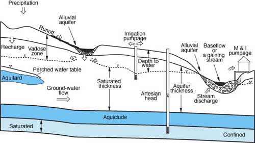
Impermeable layers also play a role in another hydrologic phenomenon known as perched water bodies. In this case locally occurring aquitards (rock or clay layers) may collect and support water that infiltrates through the soil to form the underground equivalent of a puddle. To the dismay of those who try to develop them into water supplies, perched water bodies are not connected with any larger aquifer system and are often very limited in extent. If the perching layer is leaky, it may fluctuate greatly with variations in rainfall. Figure 3 illustrates several of the terms and aquifer types discussed above.
Figure 3--A cross section of the subsurface, depicting several hydrologic situations.
In the preceding paragraphs we have focused on characteristics that determine how much water an aquifer holds (or can hold) and how easily the water may be extracted. The question of how easily water may be extracted from an aquifer on an instantaneous basis relates to a property called the specific yield, which will be discussed more in the section on well construction and ground-water production. However, an aquifer is a container of finite size and it can be effectively emptied if water removal exceeds water replenishment. The factor that determines the amount of ground water available from an aquifer over the long term is the rate of replenishment or ground-water recharge--the degree to which water removed from the aquifer is replaced over time--minus the natural discharge such as flow into rivers. The sustainable yield (also known as the safe yield) of an aquifer is often defined as the long-term average recharge rate minus the average natural discharge. However, it is important to recognize that withdrawals equal to long-term recharge can result in reduction of streamflow and wetlands, as ground-water discharge is replaced by ground-water pumpage as the means of balancing the inflow of water to the aquifer.
Withdrawals in excess of the sustainable-yield rate will result in aquifer depletion (also referred to as loss of saturated thickness, drawdown, water-level decline, etc.). The replenishment factor or recharge depends not only on the nature of the rocks but on the soil and vegetation that cover them and on the climate of the region. It is part of the water balance (or budget) of the area--the average balance between the water that enters the area and the water that is used and leaves it. Hydrologists use water-budget calculations in much the same way that homeowners balance their checkbooks or businesses monitor cash flow and assets. In assessing the ground-water resources of any region, knowledge of the water balance is as vital as knowledge of the porosity and permeability of the rocks. This is because ground water is not isolated from other water; as we have seen, it is part of the earth's total amount of water. As such, it is in more or less continuous interchange with all other water in a system of circulation called the water cycle or hydrologic cycle.
Hydrologic cycle
The hydrologic cycle is a vast and complex system that circulates water over the whole planet. Figure 4 illustrates the various parts of this cycle, which starts and ends with the oceans. Energy from the sun powers the system, causing water to evaporate from the surface of the world's oceans. This water then condenses to form large cloud masses. These clouds are moved by the global wind system and, when conditions are right, the water precipitates, falling back to the surface again as rain, snow, or hail. Most precipitation returns to the atmosphere as evaporation from water bodies or from the ground surface, and as transpiration from plants. Transpiration is very similar to respiration (breathing) in animals, and releases water vapor to the atmosphere. The processes of evaporation and transpiration are usually lumped together as evapotranspiration. Some of the water that falls onto the land generates surface runoff that collects to form streams and rivers that eventually flow back into the sea, where the process starts all over again. A final portion of precipitation--generally the smallest fraction--percolates through the soil to reach the water table and become ground water. Unless ground water is removed by pumping from wells, it flows through the aquifer towards natural discharge points, such as springs, streams and rivers, lakes, or the ocean coastline. Figure 5 illustrates these processes and provides a picture of a local part of the hydrologic cycle and the effects of ground-water withdrawal.
Figure 4--The hydrologic cycle. Precipitation falls to the earth's surface, runs off or infiltrates into the ground, then moves back into the atmosphere through transpiration or evaporation.
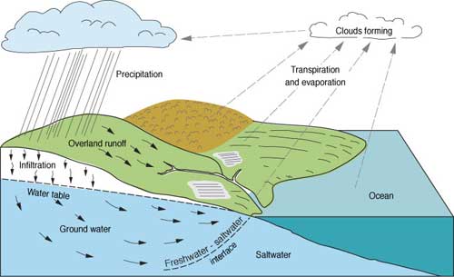
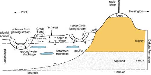
Figure 5--A schematic cross section of hydrogeology in the Great Bend area.
A ground-water system, therefore, consists of recharge from precipitation percolating into the ground, reaching the water table, and flowing through rocks of varying permeabilities towards natural discharge points. The rate at which water flows through the system depends upon the precipitation, evaporation, transpiration (respiration by plants), the geological conditions, and many other factors. Hydrogeology encompasses many fields of study because it is impossible to isolate completely one portion of the hydrologic cycle from the others, and because water in its natural cycle takes different forms in different realms--ice in glaciers, liquid and vapor in the sea, rivers, aquifers, and vapor in the atmosphere.
People have trouble visualizing and understanding ground water because it is out of sight and operates on unfamiliar scales. When we look at a river, lake, or ocean, we can see and measure its area and its depth, and we know that the water is relatively uniform throughout (homogeneous). If water is flowing, particularly in a flash flood or a summer stream, we can see and measure that process, and we have an intuitive grasp of how quickly water moves on the earth's surface. For ground water, our surface-oriented intuition does not serve us well.
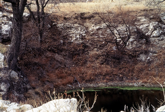
St. Jacob's Well, a spring at the bottom of Little Basin in Clark County.
Aquifers are out of sight, often difficult to identify and measure, and they are far from uniform in thickness, shape, and such important properties as porosity and permeability. When an aquifer is deep underground or extremely variable in its characteristics, obtaining a precise estimate of its extent, characteristics, or water content can be impractical. Because of the inability to accurately characterize these complex and highly variable systems, ground-water scientists and managers must accept and deal with various types and levels of uncertainty.
Although we haven't specifically said so, most of the descriptions so far assume that we are concerned primarily with aquifers containing freshwater. This is generally true, but aquifers can (and many Kansas aquifers do) contain and transport brines or other poor-quality water. Although not usable for human water supplies, these aquifers can't be ignored. Where aquifers with poor water quality are near the surface or are hydraulically connected with usable aquifers, water-quality problems may occur in freshwater supplies--this is common in much of central and southeast Kansas. In addition, deep saltwater-bearing aquifers (most notably the Arbuckle Group) are economically important because they contain hydrocarbons and are used for the injection and disposal of liquid wastes from both industry and oil-field operations. Kansas ground-water issues therefore can not be fully addressed without considering these aquifers, and we will mention them in the course of discussing freshwater supplies.
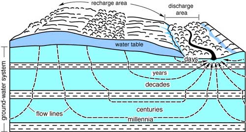
Time scales of ground-water processes also are difficult for many people to understand. Although ground water in very shallow, permeable aquifers may recharge and drain on a time scale of years to decades, deeper ground water may be thousands to millions of years old (thus, this ground water is sometimes referred to as "fossil water"). If this is the case, climatic conditions under which it was recharged may bear little resemblance to those of today, and we may not be able to define the safe yield of such an aquifer with any real confidence. Figure 6 illustrates some of these time-scale points. Recharge in the Ogallala aquifer of western Kansas, for example, is slight, and it may take many years for precipitation at the earth's surface to reach a deep aquifer.
Figure 6--Ground water moves, though slowly. Movement from the surface to a point of discharge may take years, decades, or much longer.
In much of western and central Kansas, aquifers slope or dip down slightly to the east, resulting in a west-to-east flow of the water. The flow velocities, however, are only about a foot per day-much slower than free water would flow on the earth's surface. (To gain a practical appreciation of this difference, observe how long it takes for water to flow out of a full bottle when it is tipped over with the cap off--and then repeat the experiment with a wet sponge tied firmly over the mouth of the bottle.) This means that it will take about 15 years for ground water to move a mile, almost 500 years to cross a typical county in Kansas. As we have learned to our distress, depletion and contamination may seem like local problems in the short run, but they have a way of involving all of us eventually.
Kansas aquifers
We have discussed some of the characteristics of aquifers, but when we come to identifying and describing specific aquifers, the terminology can be a bit untidy. Part of the aquifer definition problem stems from the use to which a water-bearing formation may be put. Rocks in which wells can produce a few gallons per minute (gpm) may be a perfectly adequate aquifer for domestic or livestock water supplies, but they would be completely inadequate for irrigation or municipal supply use where well yields of thousands of gpm may be required. Likewise, rocks that may transmit water over significantly long periods of time may not produce water for wells during short time periods. Still, such a formation is an aquifer in either case.
Other distinctions may arise from the background of the person defining the feature (like mountain peaks, underground features tend to be named by the person who first discovers them). Geologists often define rock layers according to their nature and origin. They usually define rock layers according to a unit called a formation, the smallest possible layer of rock that can be mapped and described over a wide area. For example, the Dakota Formation is a layer of sandstone and shale that crops out in central Kansas. However, hydrologists view aquifers in a functional sense, and may include in a single named unit a wide variety of rocks and sediments as long as they are all hydraulically interconnected. Hydrologists, therefore, talk about the Dakota aquifer, and use the term to include several geologic formations that are hydraulically connected and were deposited at about the same time in geologic history.
Both approaches have merit; the hydrologic definition is simple and practical, but an understanding of the geology can often yield important knowledge about aquifer extent or characteristics. In the description of Kansas aquifers that follows, all types occur. For example, the High Plains aquifer in western and central Kansas is a hydrologic feature that includes geologically defined units like the Ogallala Formation and various other units that can be defined either geographically or geologically (the Equus Beds, the Great Bend Prairie aquifer, etc.). Figure 7 gives the ages and geologic context of the major aquifer formations in Kansas.
Figure 7--Kansas geohydrologic timetable, showing the age and characteristics of the major Kansas aquifers. Note: Eons not shown. [*Decade of North American Geology, 1983 Geology time Scale, Geological Society of America.]
| Eras | Periods | Epochs | Estmated Length (years)* |
Description |
|---|---|---|---|---|
| Cenozoic | Quaternary | Holocene | 10,000+ | Glaciers moved into northeast at least twice, forming glacial till aquifers. Sand dunes formed by wind in west. Equus Beds and Great Bend Prairie aquifers, as well as present-day stream-channel alluvial aquifers, formed by stream and river action. |
| Pleistocene | 1,590,000 | |||
| Tertiary | Pliocene Miocene Oligocene Eocene Paleocene |
3,700,000 18,400,000 12,900,000 21,200,000 8,600,000 |
Rocks found are part of Ogallala Formation (sand, gravel, and porous rock), which contains a large quantity of ground water and occurs only in western third of state. No rocks were formed in eastern Kansas. | |
| Mesozoic | Cretaceous | 77,600,000 | Much of western half of Kansas was covered by seas. Limestone, sandstone, and chalk formed from sea deposits, and Dakota aquifer formations were deposited by stream channels and deltas. | |
| Jurassic | 64,000,000 | Most rock in Kansas is underground in west. A few small outcrops found in southwest corner, where Jurassic Morrison formation acts as an aquifer. | ||
| Triassic | 37,000,000 | No rocks have been found in Kansas. | ||
| Paleozoic | Permian | 41,000,000 | Much of Kansas was covered by several seas, which deposited limestone, shale, and chert as they rose and fell. When seas dried up, they left behind salt and gypsum in bedded deposits and "red beds" of central Kansas, which are sources of natural saltwater discharge. | |
| Pennsylvanian | 34,000,000 | Seas and swamps came and went, leaving behind coal as well as shale, limestone, sandstone, chert, and conglomerate. Pennsylvanian rocks are found at surface in eastern Kansas, and include the Tonganoxie and Ireland sandstones that serve as locally important aquifers. | ||
| Mississippian | 40,000,000 | Repeated layers of limestone, shale, and sandstone indicate that seas rose and fell. Mississippian rocks are oldest found at the surface and are used locally as source of ground water in extreme southeastern part of state. | ||
| Devonian | 48,000,000 | Seas covered Kansas during much of period. Limestone, shale, and sandstone deposits are only underground. | ||
| Silurian | 30,000,000 | Land was uplifted and seas disappeared. Limestone deposits found only underground. | ||
| Ordovician | 67,000,000 | Seas covered parts of Kansas during much of period. Dolomite and sandstone are underground, and in combination with Cambrian formations, form important aquifer in southeastern Kansas. | ||
| Cambrian | 65,000,000 | Early climate was dry and many rocks eroded. Later, dolomite, sandstone, limestone, and shale were deposited by seas. Carbonate rocks form part of Cambro-Ordovician aquifer used extensively in Crawford and Cherokee counties. | ||
| Precambrian | 3,930,000,000 | These rocks are oldest on earth. In Kansas, they are only found deep below the surface and not much is known about them. many are igneous and metamorphic and have gone through many changes. | ||
Unconsolidated aquifers
In Kansas, the shallowest, largest, and most productive aquifers are usually unconsolidated deposits of sand, gravel, silt, and clay that were deposited by water, wind, or ice. The majority of these aquifers were formed from the sediment (or alluvium) deposited by streams in bedrock valleys. Stream and river deposits of this sort are termed alluvial materials, although in today's hydrologic terminology, the alluvium associated with existing streambeds is referred to as an alluvial aquifer. Older material of alluvial origin is typically designated by some other name, such as terraces, a geologic term for broad benches of land that formed the banks of ancient rivers.
Alluvial valleys
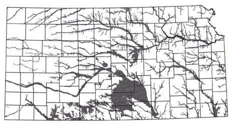
All the major rivers and many of the smaller streams in Kansas have alluvial deposits associated with them. Rivers such as the Arkansas and Republican have material from the erosional remnants of the Rocky Mountains so that commonly more coarse sand and gravel is found there. Smaller Kansas streams may have more silty or clay material derived from the limestones and shales of the area they drain. In parts of eastern Kansas alluvial aquifers are the only significant source of ground water, while in western Kansas they often overlie or intersect other shallow unconsolidated aquifers. Figure 8 shows the distribution of these aquifers, which closely follows the major streams and rivers. The thickness of the alluvial material is highly variable, ranging up to 300 feet (90 m) in some of the major river valleys such as the Arkansas. Depth to water is usually shallow (10-30 ft [3-9m]) and in many of the valleys the ground water in the alluvium is directly connected to the stream.
The South Fork of the Republican River in Cheyenne County.
Figure 8--Distribution of alluvial aquifers in Kansas.
The general flow of ground water is downstream, and there is a close relationship between streamflow and ground water in alluvial aquifers (which in turn are often connected to adjacent or underlying aquifers). During times of high streamflow, water often moves out of the stream channel and hastens recharge of the alluvial aquifers. When streamflow is low, water may flow back out of the alluvial aquifer and into the stream. This is called baseflow, and it maintains streamflow even in times of little precipitation. However, in locations where the water table in alluvial aquifers has been lowered by heavy pumping, water levels may drop to the point that the aquifer does not replenish the streamflow. Now that widespread conservation practices in agriculture--such as terracing--help keep water on the soil and allow more of it to soak in rather than run off into streams, loss of baseflow further contributes to streamflow declines.
Ground water contributes to streamflow in many of the streams in eastern Kansas. In western Kansas, however, ground-water levels in many stream valleys have declined to the point where ground water's contribution to the stream is less than in the past. In some reaches of streams such as the Pawnee, Walnut, Smoky Hill, Arkansas, and Solomon, no ground water discharges at all and the streams are intermittent, flowing only after runoff from precipitation (streams that flow only in response to precipitation are called "ephemeral streams"). This relationship between streamflow and alluvial aquifers emphasizes that ground water cannot be understood or managed without reference to the larger hydrologic cycle. In essence, ground water and surface water are inextricably linked.
The chemical quality of surface and ground waters in most alluvial valleys is acceptable for most purposes. Saltwater from Permian formations is known to leak into shallow ground water in the Solomon and Smoky Hill River valleys in Saline and Dickinson counties, in the Cimarron River in southwest Kansas, in the Ninnescah River in south-central Kansas, in the Arkansas River valley downstream from Great Bend, and other areas. Similarly, the Dakota aquifer discharges saltwater into the Saline and Smoky Hill rivers in Russell County and the Solomon River in Mitchell and Ottawa counties. High concentrations of total-dissolved-solids in ground waters (a rough measure of water quality) also are known to be present in the upper Smoky Hill Valley in Logan County and in the Arkansas River alluvial aquifer.
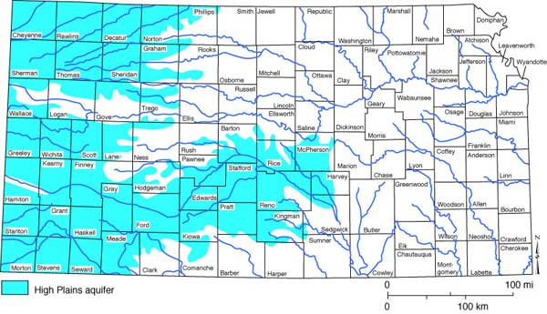
High Plains aquifer
As was discussed earlier, the High Plains aquifer is a major regional hydrologic unit that can be broken down into different geologic aquifer units formed at different times in various locations. Figure 9 shows the location of the High Plains aquifer and its major constituent formation, the Ogallala Formation. Figure 10 shows the Kansas portion of the High Plains aquifer, which includes not only the Ogallala, but also the Great Bend Prairie, Equus Beds, and alluvial and sand dune aquifers. Like the modern alluvial aquifers, these units were mainly deposited by streams flowing within, into, or through the state.
The Cimarron River runs south of Point of Rocks, an Ogallala-capped hill in the Cimarron National Grasslands of Morton county in southwestern Kansas.
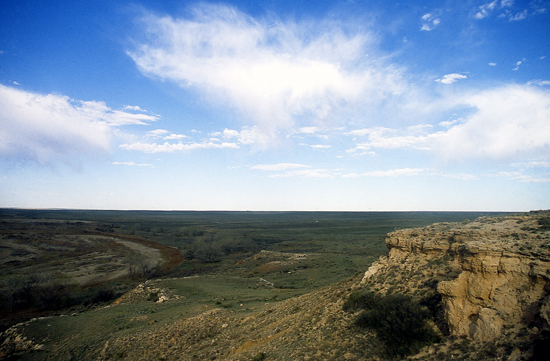
Figure 9--The High Plains aquifer underlies parts of eight states and holds enough freshwater to fill Lake Huron.
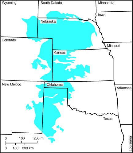
Figure 10--The portion of Kansas underlain by the High Plains aquifer.
The Ogallala Formation was deposited by streams flowing out of the Rocky Mountains about 3.8 million years ago. Those streams created an enormous alluvial fan extending out from the Rockies. It was originally a continuous layer up to 800 feet (240 m) thick that covered eastern Colorado and western and central Kansas, and extended north into Nebraska, Wyoming, and the Dakotas, and south through parts of Oklahoma and Texas. However, subsequent erosion has reduced the thickness and removed much of the formation from eastern Colorado, and the Ogallala is no longer connected to the Rocky Mountains. Where it crops out at the surface, the Ogallala commonly forms a dense, naturally cemented rock that is known locally as mortarbeds. The Ogallala appears at the surface throughout western Kansas, particularly at locations where streams have eroded through soil, such as in the Smoky Hill River and other drainage areas and at Lake Scott State Park in Scott County. The Ogallala also is found at the surface in parts of central Kansas. Even at the surface, the pore space in the Ogallala is obvious, and it is easy to see why the Ogallala captures and holds water in the subsurface.
In western Kansas, the Ogallala is up to several hundred feet thick in places; it is thickest in southwestern Kansas. In places, tens to hundreds of feet of the Ogallala are saturated with good quality water. The quality of Ogallala water is particularly high because the sands and gravels of the formation have a low solubility and act as a filter and to help purify the water. However, depth to water may be substantial and is increasing because irrigation pumping is far in excess of recharge. Recharge to the Ogallala is from precipitation and is limited to approximately 1/4-1/2 inch per year in most of western Kansas. The direction of ground-water flow is from west to east.
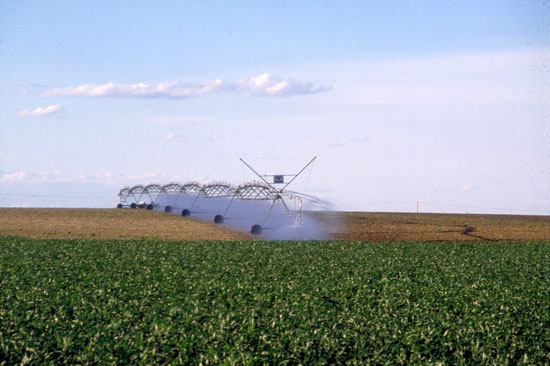
In recent years, the High Plains aquifer has come under increasing pressure as a source of water for irrigation. With the introduction of large-capacity pumps and technological improvements such as center-pivot irrigation, the aquifer has been pumped heavily. Water from the aquifer has made it possible to grow thirsty crops such as corn that otherwise could not be raised with the scant rainfall in western Kansas. With the use of that ground water, however, has come a drastic decline in the High Plains aquifer water levels. In west-central Kansas--particularly in the counties of Wichita, Scott, and Finney--and in some areas of southwestern Kansas, more than 50% of the water originally in place in the High Plains aquifer has been used. The situation is less severe in northwestern Kansas, where irrigation has been less developed and the decline has been less substantial; in those locations, the water table is 10-25% lower than it was before the days of ground-water development.
A center-pivot irrigation system in Trego County.
In terms of measured declines in the water table, a 10-foot (3-m) decline has been common across much of western Kansas. The much greater declines--in some cases the water table is now 200 feet (60 m) below its level prior to irrigation--are mostly centered in southwestern and west-central Kansas, where irrigation development has been greatest and the amount of water in the aquifer has been greatest.
Those statistics indicate substantial water use. However, in parts of western Kansas, where the High Plains aquifer was originally several hundred feet thick, considerable water remains. Even in those locations, the drop in the water level has meant that irrigators must pump the water farther to get it to the surface. That extra pumping requires increased energy use, which in turn has slowed use of the water. Increased awareness of the finite nature of the High Plains aquifer also has slowed use of the aquifer in the past few years. Irrigators have employed increasingly more efficient irrigation methods. Finally, irrigated acreage has decreased somewhat. These factors, and others, have slowed declines. Still, substantial amounts of pumping continue in the High Plains, often in excess of recharge. The eventual outcome may be some leveling off of use and a stabilization of water levels. In some areas, the High Plains aquifer may become depleted to the point that it is no longer useful for irrigation, although it should be able to continue as a source of municipal and domestic water.
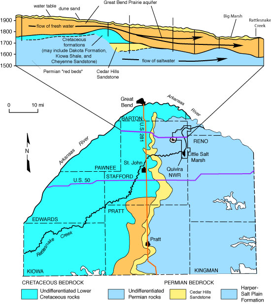
The Great Bend Prairie aquifer, in central Kansas, is largely similar in composition to the Ogallala. However, it was deposited by ancestral equivalents of the Arkansas River and other streams such as Walnut Creek and the Pawnee River. The Great Bend Prairie aquifer ranges in thickness from 350 feet (106 m) in areas of Kiowa and Edwards counties to a featheredge in Kingman and Reno counties. The aquifer overlies the Dakota aquifer in the west and Permian shales and siltstones farther east. It is an unconfined aquifer and yields up to 1,500 gpm to wells. Water quality is variable due to an influx of salty ground water from the underlying Permian rocks (see Figure 11). Where this saltwater intrusion occurs, ground-water depletion results in a further deterioration of water quality. That is because heavy pumping of freshwater may allow upward flow of the underlying saltwater, contaminating the freshwater above. Depth to water in this aquifer ranges from 5 to 30 feet (1.5-9 m) but may be as much as 150 feet (45 m) in some areas. Natural ground-water flow is primarily from west to east, with some natural discharge occurring to Rattlesnake Creek, the North and the South forks of the Ninnescah River and in and around Quivira Marsh.
Figure 11--The lower figure shows the bedrock geology of the Great Bend Prairie. The upper figure is a cross section showing that the area is underlain by Permian bedrock. Salty water from those Permian rocks can move into and contaminate the overlying freshwater aquifer.
The Equus Beds is an alluvial deposit of the ancestral Smoky Hill River, deposited when that stream flowed south into the Arkansas River. The deposit fills an abandoned river channel (known as the McPherson channel) in McPherson and Harvey counties. In places, the alluvium also fills areas of subsidence caused by dissolution of the underlying Hutchinson salt. Thickness ranges from 0 to approximately 270 feet (0-82 m) and depth to water from 5 to 10 feet (1.5-3 m) to 60 or 70 feet (18-21 m). The deep ancestral channel of the Arkansas River lies to the south and southwest of the McPherson channel and has sediment thicknesses of over 300 feet (90 m) in an area where solution of salt beds in underlying bedrock has caused subsidence. Wells yield up to 1,000 gpm, and water quality is generally good for most purposes. However, salt contamination is a concern because of natural brine discharges to the west and human activities (oil-field brine disposal and salt-mining wastes). This aquifer is the primary water source for the city of Wichita, and water-table declines of up to nearly 30 feet (9 m) have taken place in the southern part of the area due to pumping for municipal and agricultural purposes. Ground-water-flow directions in the Equus Beds aquifer are primarily toward and along the axis of the McPherson channel, which trends in a southerly direction in McPherson County and turns to the southeast in Harvey County. The flow in the Arkansas River alluvium adjacent to the Equus Beds is to the southeast and generally parallels the Arkansas River.
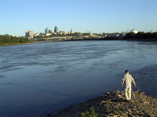
Other alluvial aquifers in Kansas are not as broad as those discussed above, but extend for appreciable distances along major rivers. The Kansas River valley contains a very productive alluvial aquifer extending from Junction City to Kansas City, with saturated thicknesses of more than 40 feet (12 m) along nearly all of this distance. The alluvium of the Republican River also contains saturated thicknesses of more than 40 feet (12 m) from within Republic County to Clay Center, and thicknesses of more than 80 feet (24 m) north of Concordia. The Missouri River alluvium is thickest and most used in Kansas near its junction with the Kansas River valley at Kansas City. Alluvial aquifers in other river valleys in Kansas such as the Smoky Hill, Solomon, Saline, Neosho, Marais des Cygnes, and Verdigris also are locally important sources of ground water. Saltwater intrusion from underlying Permian bedrock limits the use of ground water in the Smoky Hill River valley in eastern Saline and western Dickinson counties.
The confluence of the Kansas and Missouri rivers at Kansas City. Alluvial aquifers neighbor both rivers.
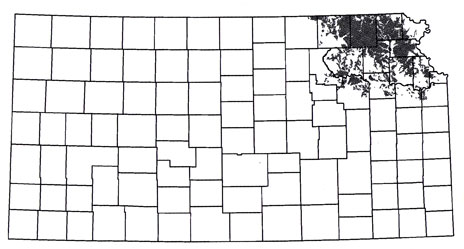
Glacial deposits
During one of the ice ages, about 750,000 years ago, the northeast corner of the state was invaded by continental glaciers that scraped up and transported large quantities of material ranging in size from boulders to clay. The extent of these glaciers into Kansas was roughly east of the Big Blue River and north of the Kansas River. The farthest penetration of the glaciers is marked in places by deposits of red quartzite boulders that were hauled by the glacier from the area around Sioux Falls, South Dakota, southwest Minnesota, and northwest Iowa. When the ice melted and the glaciers receded, this material was left behind, especially in low-lying areas. These deposits are now common in an area north of the Kansas River to the Nebraska state line and east of Tuttle Creek Reservoir to the Missouri River (Figure 12). Some of the most prolific water-bearing formations are buried valleys--ancient river valleys partly filled with alluvium that was covered by glacial debris. The pore space in this alluvium is excellent at trapping and holding ground water. These aquifers, however, are not widespread. The alluvial deposits are quite variable and range in thickness from 0 to more than 200 feet (0-60 m). The materials that filled and buried the valleys range from clay to sand and gravel, and the poorly sorted, coarse-grained deposits at the bottom of the valleys yield large quantities of generally good-quality water. The buried valleys may be up to several miles wide, 400 feet (120 m) deep, and tens of miles long. Water levels are commonly between 5 and 50 feet (1.5-15 m) below land surface, but locally they may exceed 100 feet (30 m). Because these valleys are buried, they are difficult to locate. Published reports, water and oil and gas well records, test drilling, and geophysical techniques are used to help delineate the aquifers.
Figure 12--Glacial aquifers in Kansas.
High concentrations of iron, manganese, sulfate, nitrate, chloride, sodium, hardness, and total dissolved solids occur in the ground water in parts of northeastern Kansas. While many of these concentrations result from hydrogeologic conditions and cause only aesthetic, scale, or taste problems, high nitrate concentrations may cause cyanosis in infants and some young livestock. Some high values of calcium, sodium, sulfate, and chloride may result from the movement of poor-quality water from bedrock surrounding the glacial buried valleys.
Bedrock aquifers in Kansas
In Kansas, ground water occurs in many consolidated sandstones and limestones, and occasionally in fractured shales. Aquifers in consolidated rocks are the only local source of water for the people living in many parts of the state. This is particularly true for much of eastern and parts of central Kansas where surface waters and shallow aquifers in unconsolidated sediments are scarce or unavailable. The Cambro-Ordovician and Dakota aquifers are the most significant sources of usable water in the consolidated rocks of Kansas. Other locally important sources of fresh water can be found in sandstones in the Codell Formation of central and west-central Kansas. Other important bedrock aquifers are Permian limestones in the Flint Hills of east-central Kansas, Pennsylvanian sandstones and limestones in eastern Kansas, and the Mississippian limestones in extreme southeast Kansas.
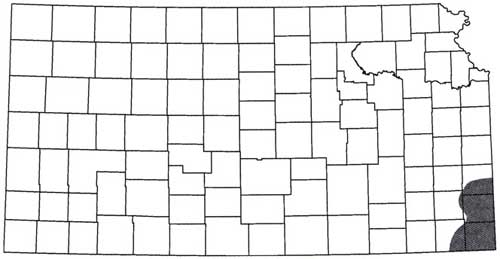
Cambro-Ordovician aquifer
The Cambro-Ordovician aquifer (locally referred to as the Arbuckle or Roubidoux aquifer) is a confined aquifer system in Kansas and is an important source of water for many communities, industries, and rural water districts in Crawford, Cherokee, and southeastern Bourbon counties. In the Ozark region of southern Missouri and northeastern Oklahoma, the Cambro-Ordovician aquifer is the major source of water. In southeastern Kansas, the depth to the top of the aquifer ranges from 200 feet (60 m) in southeast Cherokee County to more than 1,000 feet (300 m) in northwest Crawford County. Well yields typically range from 150 gpm to more than 1,000 gpm. Recharge to the southeast Kansas portion of the aquifer comes from precipitation falling on the Ozark region in southern Missouri where the rocks that comprise the Cambro-Ordovician crop out at the surface. Figure 13 shows the aquifer location and extent of usable water in the Cambro-Ordovician. In southeast Kansas, the ground-water recharge moving westward and northwestward encounters saltwater present in the Cambro-Ordovician aquifer farther to the west. As a result, the usable portion of the aquifer is restricted to those areas now being developed in southeast Kansas. In this case the entire formation functions as an aquifer, but water quality limits the portion that is useful.
Figure 13--Cambro-Ordovician aquifer in Kansas.
Dakota aquifer
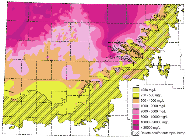
The Dakota aquifer is used by communities, industries, and agriculture as a source of water in parts of central and western Kansas. At the surface, the Dakota Formation is probably best known for the red sandstones and clays that crop out in central Kansas. This aquifer consists of shales and discontinuous sandstone bodies that were deposited in stream channels and river deltas along an ancient seashore during the Cretaceous Period. Where the aquifer is covered by younger Cretaceous strata, it is confined and the depth to the top ranges up to 2,600 feet (790 m) in extreme northwest Kansas. In central and a few areas of southwestern Kansas, the strata that comprise the Dakota aquifer crop out at the surface and the aquifer is unconfined. In much of the southwestern part of the state, the Dakota underlies and is hydraulically connected to the High Plains aquifer. In parts of central Kansas, the Dakota overlies saltwater-bearing aquifers in Permian strata and is recharged, in part, by saltwater, making the aquifer's water unusable. This situation is illustrated in Figure 11. The usable portion of the aquifer in southwest and central Kansas is shown in Figure 14.
Figure 14--Usable portion of the Dakota aquifer in southwest and central Kansas. The Dakota outcrop/subcrop area is shown by the diagonal lines; the usable water quality (less than 2,000 mg/L total-dissolved solids) is indicated by the different colors. Nearly all outcrop/subcrop area contains usable water. Area is shown in the western two-thirds of Kansas (compare with figure 10 for location).
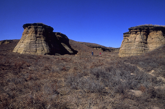
An outcrop of sandstone in the Dakota Formation.
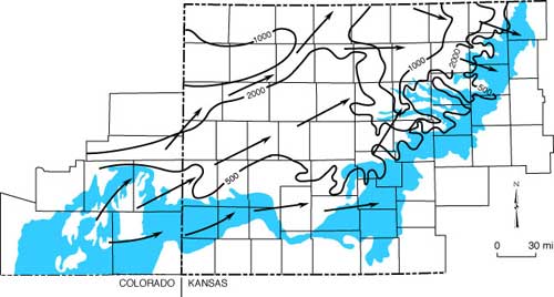
Ground-water flow in the Dakota aquifer is from recharge areas in southwestern Kansas and southeastern Colorado towards discharge areas in central Kansas and southeastern Nebraska. The directions of regional ground-water flow are shown in Figure 15. Well yields from the Dakota aquifer range from less than 10 to more than 2,000 gpm but average between 50 and 100 gpm. This wide range in wells yields is primarily due to the variation in the proportion and nature of sandstone contained in the Dakota aquifer from one location to another. In southwestern Kansas well yields from the Dakota and underlying Jurassic sandstones are generally higher than the average due to hydraulic connection with the overlying High Plains aquifer.
Figure 15--The direction of ground-water flow in the Dakota aquifer. Recharge enters the aquifer in southeastern Colorado and southwestern Kansas, then moves out of the aquifer in central Kansas.
With the depletion of the High Plains aquifer, there is growing interest in the Dakota aquifer as a possible water source. The Dakota has generally not been used heavily in western Kansas because it is considerably deeper than the Ogallala Formation (and thus water is more expensive to pump to the surface), because its quality is variable, because yields from the Dakota are generally much less than from the Ogallala, and because information about the Dakota is scarce. To help provide guidance in the use of the Dakota aquifer, the Kansas Geological Survey, in conjunction with the U.S. Geological Survey, has under-taken a multi-year study of the aquifer, which should help define its extent and the quality of water it contains.
Mississippian aquifers
In southeast Cherokee County unconfined aquifers in Mississippian limestones provide limited water for domestic use only. In this area, contamination from past lead-and-zinc mining activities in the Tri-State mining district is a concern. Recharge to these aquifers is from local precipitation falling on the land. Some of this ground water is discharged from springs and seeps in the Spring River valley. Wells yield from less than 10 to more than 100 gpm.
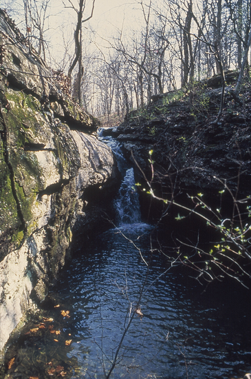
Water flowing over limestones of Mississippian age in Cherokee County in southeastern Kansas.
Sandstone aquifers
Many small towns, rural water districts, and individuals in eastern Kansas rely on Pennsylvanian sandstones and limestones for water. The principal aquifers here are the Tonganoxie and Ireland sandstones, which are generally medium- to fine-grained, and occur in ancient river valleys cut into older bedrock. Total thickness of these sandstones may exceed 100 feet (30 m) in places. Currently these aquifers supply water to much of the rural population living in upland areas away from accessible sources of surface water such as streams or reservoirs. Typical well yields range from less than 5 to more than 50 gpm. Other units within the Pennsylvanian, including sandstones and fractured limestones, are capable of producing water locally. Typically wells penetrating these units yield less than 5 gpm. Recharge to the Pennsylvanian aquifers comes primarily from precipitation in areas where the aquifer crops out or occurs in the shallow subsurface. The deeper these units are buried, the higher the total-dissolved solids and chloride concentrations in the water they contain.
Ground-water quality also may pose problems for some people whose supplies come from the sandstones in the Douglas Group in northeastern Kansas. Several public-water-supply well fields are located in areas where this aquifer has a large total-dissolved-solids content but is still usable. Chemical-quality changes caused by the lateral movement of saline waters are likely to occur in these well fields if the wells are pumped too intensively.
Permian aquifers
In the Flint Hills of Kansas, limestone aquifers of Permian age in Chase and Council Grove groups provide water for farmsteads and several small communities. Ground-water flow is toward wells, stream valleys, and springs, such as Diamond Springs in Morris County, a well-known stop along the Santa Fe Trail in the 19th century. Most wells yield water at a rate of 100 gpm or less. However, discharge from individual springs in the region may be considerably higher than 100 gpm. For example, the town of Florence, in Marion County, derives its municipal water supply from a local spring. In central and west-central Kansas, wells in the Codell Sandstone yield water at generally less than 10 gpm.
Prev Page--Use || Next Page--Quality
Kansas Geological Survey, Kansas Ground Water
Comments to webadmin@kgs.ku.edu
Web version Jan. 2005. Original publication date August 1993.
URL=http://www.kgs.ku.edu/Publications/Bulletins/ED10/04_occur.html