![]()
Prev Page--Geologic setting || Next Page--Digital model
Hydrologic Setting
Figure 4 shows conceptual block diagrams depicting the ground-water flow pattern which led to the formation of the Wellington aquifer. Originally the depositional edge of the salt probably was several miles farther east where salt interfingered with shale that was washed into the Permian basin from low-lying border areas. During and following removal of most of the Cretaceous and the upper part of the Permian rocks by erosion, fresh ground water from surficial deposits was able to penetrate to the salt body. This resulted in differential dissolution of large parts of the salt and consequent westward migration of the edge of the salt body.
Figure 4. Conceptual block diagrams near Lindsborg showing geologic development, mechanism of dissolution of the Hutchinson Salt Member, and development of Wellington aquifer between Cretaceous time (A) and present (B).
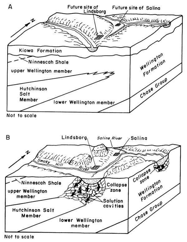
Owing to the west-southwestward dip of rocks in the area, the lower Wellington member generally subcrops beneath the undifferentiated Pleistocene deposits east of the salt body, as depicted in a series of cross sections on plate 2. Circulating ground water also has caused large-scale dissolution of gypsum and anhydrite in the lower Wellington. The dissolution of gypsum and anhydrite appears to be best developed in the Smoky Hill River valley and in the area between Belle Plaine and Geuda Springs.
Fracturing, slumping, and collapsing of overlying deposits in the Wellington Formation occurred coincidentally with the solution of salt, gypsum, and anhydrite at many locations along the solution trend. These mechanisms also influenced the depositional patterns of Pleistocene streams resulting in accumulation of unconsolidated deposits as mentioned earlier. This process has altered the normally impermeable unit into one that is capable of transmitting large quantities of water at a few locations. This permeable unit has been named the Wellington aquifer; the solution zone in the salt and the solution zones in the gypsum and anhydrite are termed, respectively, the "salt-dissolution zone" and the "gypsum-dissolution zone."
Ground water in the Wellington aquifer moves downgradient in two directions from a potentiometric "high" east of Hutchinson. One vector indicates northward movement of saltwater through the salt-dissolution zone and discharge through the gypsum-dissolution zone into the Smoky Hill River alluvium between New Cambria and Solomon. The other vector indicates southeastward movement of saltwater through the salt-dissolution zone and discharge through the gypsum-dissolution zone in the vicinity of Belle Plaine, Adamsville, and Geuda Springs.
The degree of permeability development in the Wellington aquifer is indicated by the frequency that drillers report a rapid loss of drilling fluid into voids as they penetrate the dissolution interval that comprises the aquifer. As a result, drillers have applied the name "lost-circulation zone" to the interval. The degree of permeability development in the Wellington aquifer was examined on the basis of drillers logs of wells in the area. The logs indicate that there are many more reports of "lost-circulation" in the area from Salina to Wichita than in the area south of Wichita. The former area is associated with thick sections of salt that are subject to the dissolution and collapse that greatly increase permeability. The latter is near the depositional edge of interbedded salt and shale where dissolution would cause less significant collapse and increased permeability.
The thickness of the Hutchinson Salt Member is shown on plate 3; the altitude and configuration of the top of the member also is shown. As shown in plate 3, the Hutchinson Salt Member generally thickens southward and southwestward from about 200 to 500 feet. Along the eastern edge of the member, the abrupt decrease in thickness of as much as 200 feet coincides with the dissolution zone. The trend of this zone, which corresponds with the Wellington aquifer, extends from northwest of Salina through central Saline, western McPherson, western Harvey, eastern Reno, central Sedgwick, and central Sumner Counties. Another area of apparent salt solution, as indicated by abrupt thinning, occurs east and south of Wellington.
The colored part of plate 3 denotes areas where thick salt beds are present. In stippled areas, data from electric logs indicate the presence of thin salt layers Interbedded with shale suggesting a sequence representative of the original depositional edge of the salt. However, the salt layers in stippled areas also may represent numerous outliers remaining after widespread dissolution occurred.
The top of the Hutchinson Salt Member, as shown on plate 3, has a regional dip that ranges from westerly in the northern part of the area to southwesterly in the southern part. Plate 3 also shows the rapid thinning of the top of the salt along the eastern margin, as evidenced by local reversals in dip.
Depths below land surface to the salt-dissolution zone range from 205 feet in the area northwest of Salina to about 550 feet in the area southeast of Hutchinson near the Arkansas River. Southeastward from this area the depths below land surface to the salt-dissolution zone are about 220 feet near Clearwater and 120 feet at Belle Plaine.
Depths to the gypsum-dissolution zone in the Smoky Hill River valley range from about 200 feet in the area immediately east of the salt-dissolution zone to about 60 feet (at the base of the alluvium) in the New Cambria-Solomon area. Depths to the gypsum-dissolution zone in the southern part of the study area range from about 200 feet in the area northeast of Wellington to land surface near Geuda Springs, where saline water is present, in the form of seeps and springs.
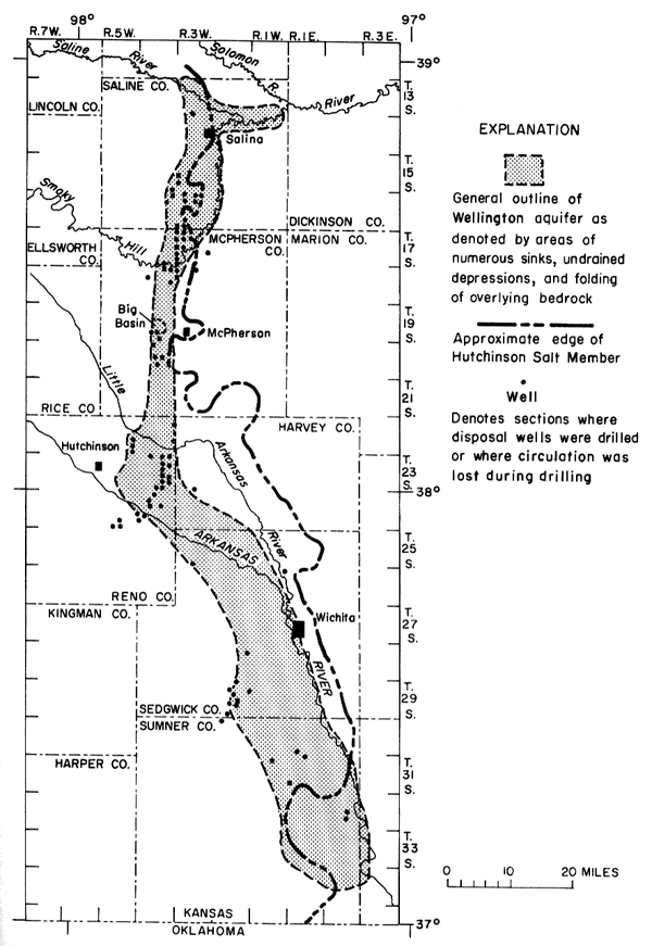
The Wellington aquifer is located in an area that has undergone intensive exploration for oil and gas trapped in deeper horizons. Prior to implementation of pollution protection standards by the State of Kansas, the aquifer was used extensively for disposal of brine produced in association with oil and gas. Many disposal wells have been drilled, and the general limits of the aquifer are defined by their location. Figure 5 shows where disposal wells were, or are located, and where circulation was reportedly lost during drilling. Elsewhere, the limits of the Wellington aquifer are nebulous and are defined mainly by topographic and geologic evidence as discussed later.
Figure 5. General outline of Wellington aquifer as denoted by areas of sinks and undrained depressions, locations of disposal wells, and areas where lost circulation was reported.
Uses of Ground Water in Wellington Aquifer
Ground water in the Wellington aquifer has been used for several purposes. On the west side of the McPherson channel near Conway, brine is withdrawn from wells in the aquifer and used to displace LPG (liquified petroleum gas) that is stored in "jugs" or cavities in the Hutchinson Salt Member. These jugs are formed by dissolving the salt with freshwater pumped from the "Equus beds." During summer months the brine is displaced from the jugs as LPG storage occurs. The brine is either stored in lined surface pits, disposed into deeper horizons such as the Arbuckle Group of Cambrian and Ordovician age, or occasionally returned to the Wellington aquifer. Between summer 1968 and winter 1974-75 almost 26 million barrels of brine were withdrawn from the Wellington aquifer and more than 27 million barrels were injected into the aquifer (John Mooney, oral commun., 1976).
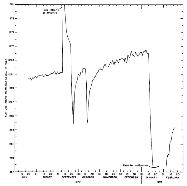
Figure 6 is a hydrograph of well 19-4W-34BDA completed in the Wellington aquifer near Conway. The hydrograph depicts a generally rising potentiometric surface on which is superimposed the effects of barometric pressure changes, pumping, and injection. Pumping from the aquifer extended from September 19-23, 1977, and from October 11-14, 1977. Pumping began again on January 10, 1978; the ending date is unknown owing to lack of record but probably occurred about January 25, 1978. Injection into the aquifer occurred from September 7-10. 1977. Minor fluctuations in the potentiometric surface are due to changes in barometric pressure.
Figure 6. Hydrograph of well 19-4W-34BDA showing fluctuation of potentiometric surface of Wellington aquifer in response to changes in barometric pressure, pumping, and injection.
Southwest of Wichita, near Clearwater, large quantities of brine were formerly withdrawn for industrial purposes. However, because of economic factors and excessive quantities of calcium, manganese, and sulfate, removal of brine from the Wellington aquifer was curtailed in about 1955 in favor of solution mining of the salt. The brine wells continued to be used as disposal wells until they became plugged with slurry containing carbonates and hydroxides of calcium and magnesium (Leonard and Kleinschmidt, 1976).
Brine is withdrawn at a rate of about 1,000 bbl per day from the Wellington aquifer and used for secondary recovery operations in an oilfield in southern Saline County.
Hydraulic Characteristics of Wellington Aquifer
In an attempt to determine the hydraulic characteristics of the Wellington aquifer, 24 observation wells were completed in the aquifer between Solomon and Geuda Springs (pl. 4). Sixteen wells were completed in the salt-dissolution zone and eight in the gypsum-dissolution zone. Reported water levels from two wells operated by Vulcan Materials Co., Oatville, Kansas, were also used. The installation of these observation wells illustrates the discontinuity of the Wellington aquifer. Circulation was lost in salt- or gypsum-solution cavities at 10 sites. The remaining wells were screened in intervals that were believed to be stratigraphically equivalent to the Wellington aquifer and that appeared permeable based upon drilling time, drilling-fluid loss, sample appearance, and increase in specific conductivity of drilling fluid.
Upon completion, attempts were made to remove drilling water by pumping the wells so that formation water would be obtained when the wells were sampled for chemical analysis. The observation wells that were screened in solution cavities were easily pumped, and formation water was obtained. Also, water levels recovered rapidly. However, at the sites where circulation was not lost, pumpage could not be sustained due to the exceedingly low hydraulic conductivity of the formation. In these cases, water was pumped from the well to ascertain if the water level would recover, thereby indicating that hydraulic connection existed between the well and the aquifer. Water levels recovered to static levels in all wells in 2 days. Repeated evacuation of the wells and subsequent water-level recovery indicate that hydraulic connection does exist between the wells and the Wellington aquifer.
Another indication of hydraulic connection between the wells and the aquifer is the fact that as more drilling water was removed, the water became significantly more concentrated with chloride. The increase in chloride concentration varied from one site to the next. However, chloride concentrations approached saturation levels (180,000-190,000 mg/L chloride) only in the wells that were completed in solution cavities. Additionally, the potentiometric surface defined by the water levels measured in observation wells is continuous, indicating that hydraulic connection exists throughout the Wellington aquifer system.
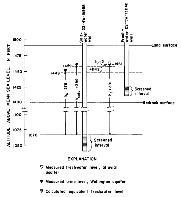
Because water in the Wellington aquifer has very high concentrations of dissolved solids (high density), water levels are lower than comparable levels of freshwater. Thus, water-level measurements in the aquifer have been adjusted to equivalent freshwater levels. The equivalent, or calculated water levels, comprise the control for the potentiometric map of the Wellington aquifer (pl. 4). For example, measurements near Buhler show that the altitude of the potentiometric surface in the Wellington aquifer is 1,449 feet above mean sea level in well 22-4W-19BBB (fig. 7). If the top of the screened interval in the well is used as datum (1,070 feet), the hydraulic head (hw) of the brine is 379 feet. The altitude of the measured water level in a well in 22-5W-13DAD, completed in the freshwater aquifer, is 1,461 feet. Thus, the hydraulic head (hf) above the same datum is 391 feet, or 12 feet (Δh) above the potentiometric surface of the Wellington aquifer. If the head in well 22-4W-19BBB is adjusted for density of 1.026 (measured from chemical analysis), the calculated head (hcalc) of an equivalent freshwater column is given by:
hcalc = 1.026 x hw
= 1.026 (379)
= 389 feet.
Thus, the observed freshwater head is only 2 feet higher in altitude than the calculated head of an equivalent freshwater column above datum. This residual difference (hr) is the part of Δh not accounted for by density differences and probably represents head loss across Intervening beds.
Figure 7. Comparison of measured and calculated water levels near Buhler.
Hydraulic Connection Between Wellington Aquifer and Overlying Unconsolidated Aquifers
Topographic evidence of hydraulic connection between the unconsolidated deposits and the Wellington aquifer is present in the form of hundreds of sinkholes that have developed in the unconsolidated deposits (fig. 5). These sinkholes, which range in area from 10 ft2 to more than 4 mi2 (Big Basin, west of McPherson), have been formed by dissolution of the underlying salt, resulting collapse of the overlying shale, and settling of the unconsolidated deposits. The fact that many sinks have developed since the area has been populated adds support to the hypothesis that salt solution is still continuing.
Where the salt section is Intact, the thickness of the upper Wellington member is relatively uniform. Based on this assumption of uniformity, if the top of the intact portion of the salt is projected eastward, the Hutchinson Salt Member, lower Wellington member, or collapsed portion of the Wellington aquifer subcrops at the base of the unconsolidated aquifers in several areas (pl. 2). Thus, there exists a direct avenue of hydraulic communication between unconsolidated aquifers and the Wellington aquifer. If the collapsed portion of the Wellington aquifer is permeable, freshwater from the unconsolidated deposits could move downward into the Wellington aquifer. However, if the head in the Wellington aquifer is higher than the head in the unconsolidated deposits, potential exists for saltwater to move from the Wellington aquifer upward into the unconsolidated deposits.
Changes in the chloride concentration of water from wells completed in the Wellington aquifer suggest localized connections with overlying freshwater aquifers. When pumping begins, water from wells in the Conway area is about 85 percent saturated with salt (Leonard and Kleinschmidt, 1976). With continued pumping, the water soon becomes saturated. During nonpumping periods, a relatively small amount of fresh ground water infiltrates through the collapsed shale overlying the Wellington aquifer and occupies a position overlying the saltwater. When pumping begins, stratification is destroyed by mixing, and the fresher water is removed early during the pumping period.
Lane and Miller (1965) observed a general increase in chloride concentration with depth in the alluvium of the Arkansas River valley southeast of Hutchinson. The observed trend could be the result of: (1) poor sampling methods, (2) saline water derived from surface contamination and consequent settling toward the base of the unconsolidated deposits owing to the higher density of the chloride, or (3) upward leakage from the Wellington aquifer.
Although many water samples have been collected for analyses, the methods of collection and analysis have varied widely. For example, many sampling locations and depths are poorly documented. Thus, a comprehensive description of water quality in this area based on existing data is not possible. Moreover the reach of the Arkansas River and adjacent alluvium from Hutchinson to Wichita has received localized contamination in the past from oilfield activities, from brine emitted from salt plants, and, in a few places, by inadequately treated sewage (Bayne, 1956).
The ancestral Arkansas River has eroded much of the confining layer between the alluvial aquifer and the Wellington aquifer along the reach southeast of Hutchinson. In T. 24 S., Rs. 3 and 4 W. and T. 25 S., R. 3 W., less than 100 feet of shale is present between the two aquifers (pl. 1 and section E-E , pl. 2). The possibility exists that there is upward flow of saltwater into the alluvial aquifer in this area.
Additional evidence of hydraulic connection is the relationship between the water table in the freshwater deposits and the potentiometric surface of the Wellington aquifer. Plate 1 depicts the contours of the water table in the freshwater aquifers where they overlie the Wellington aquifer. The water table of an aquifer reflects the influence of geology, hydrology, and topography. The shape of the water table, as shown by contour lines, indicates the slope and direction of ground-water movement.
The water-table "high" in the area just east of Hutchinson reflects the combined factors of a relatively high bedrock surface (pl. 1) and dune sand deposits on the land surface. The linear area of dune sand, which extends about 16 miles eastward from Hutchinson to the Little Arkansas River, affords an excellent catchment for precipitation. Thus, recharge to the shallow water table probably is greater than that in surrounding areas and contributes to local mounding. A ground-water divide is present about 4 miles south of McPherson. Ground water flows southward and southeastward from the divide toward the Little Arkansas and Arkansas River valleys and northward toward the Smoky Hill River valley.
Water-table contours indicate that the Arkansas River between Hutchinson and Wichita is essentially in equilibrium with the alluvial aquifer, neither gaining water from nor losing water to the alluvium. Contours flex sharply upstream as they cross the Smoky Hill, Little Arkansas, and Ninnescah Rivers, the Arkansas River below Wichita, and Slate and Salt Creeks. These flexures indicate groundwater is discharging to these streams during low-flow conditions. Other ground-water discharge from the alluvium includes wells, streams, springs, evapotranspiration, subsurface outflow from the area, and downward leakage to the underlying Permian rocks.
The water-table gradient is markedly steeper on the west side of the unconsolidated deposits between Lindsborg and Hutchinson and on the southwest side of the Arkansas River valley, west of Wichita. In these areas, the water moves from bedrock terrain through thin, silty residual material before entering the thick, highly permeable sand and gravel in the valley.
Recharge to the alluvial aquifer is principally by precipitation and subsurface inflow from outside the area of investigation. Recharge to the deposits in the vicinity of the Wichita well field is estimated at 20 percent of precipitation (Williams and Lohman, 1949). This value probably is a reasonable estimate for the entire study area. The principal areas of subsurface inflow are in the Saline, Arkansas, and Smoky Hill River valleys; minor amounts of subsurface Inflow occur in the Little Arkansas and Ninnescah River valleys.
Plate 4 shows the observed potentiometric surface of the Wellington aquifer and the potentiometric surface calculated by the steady-state model (discussed later). Owing to lack of control, the potentiometric surface of the Wellington aquifer is more generally defined than the water table of the fresh-water aquifers. However, a comparison of plates 1 and 4 shows that the two surfaces are similar in form. This similarity provides additional evidence that ground water in the Wellington aquifer results from downward leakage of freshwater from the overlying deposits. Plate 4 shows: (1) An area east of Hutchinson with a relatively high potentiometric surface bounded on the north and southeast by two areas of steep hydraulic gradient and (2) gradual hydraulic gradients north and southeast toward outflow areas in the Smoky Hill River valley and in the Belle Plaine-Adamsville-Geuda Springs area, respectively.
There are three major areas where observed potentiometric heads in the Wellington aquifer are higher in altitude than observed water levels in the freshwater deposits (pl. 1). Thus, there is potential for upward leakage of saltwater from the Wellington aquifer to the overlying freshwater systems. Two of these areas are synonymous with the saline-water outflow areas in the Smoky Hill River valley and in the Belle Plaine-Adamsville-Geuda Springs area.
The outlined areas show only where there is potential upward leakage. In addition to the necessity for heads in the Wellington aquifer being higher in altitude than heads in the water table of the freshwater aquifers, hydraulic connection must exist between the two aquifers. The confining bed overlying the Wellington aquifer in the northern and southern areas has been subjected to fracturing and slumping concurrent with dissolution and removal of salt and gypsum. Moreover, the confining bed is relatively thin in both areas, ranging from 50 feet to 150 feet. The fact that saline-water inflow to the freshwater system does occur in these areas Indicates that hydraulic connection exists between the two systems.
The third major area of higher observed potentiometric heads is east of Hutchinson. The potentiometric surface in observation well 23-4W-30ABB, completed in the Wellington aquifer, is higher in altitude than the water table in the alluvial aquifer when density corrections are made as previously described. However, the thickness of shale in the upper Wellington member in this area averages about 300 feet. Even with the noted head reversals, it is doubtful that the head differential is great enough to overcome the flow-retardation effects of such a thick confining layer. A more probable area of possible saline-water inflow is the Arkansas River valley to the south, as discussed earlier.
It is emphasized that saline-water inflow to the freshwater system probably does not occur throughout the entire shaded areas on plate 1. Owing to the lack of control, the contours of the observed and calculated potentiometric surface are very generalized. With added control, the areas denoting saline-water inflow could be defined to a much greater degree.
Prev Page--Geologic setting || Next Page--Digital model
Kansas Geological Survey, Geology
Placed on web Jan. 2006; originally published 1981.
Comments to webadmin@kgs.ku.edu
The URL for this page is http://www.kgs.ku.edu/Publications/Bulletins/CQS9/04_hydro.html