![]()
Prev Page--Geography || Next Page--Geology
Geomorphic Development
Tertiary Time
Little evidence of a pre-Pleistocene surface remains in the mapped area. The closest known deposit of possible Tertiary age is a chert gravel 6 miles west of Kiro and north of Silver Lake which rests on a bedrock floor which in turn is more than 150 feet above the flood plain of Kansas River. Many late Tertiary chert gravels which once filled stream channels remain as isolated deposits on divides in Osage and Franklin counties. The topographic position of the gravel suggests at least 150 feet of post-Tertiary erosion in the major valleys. However, some of the uplands protected by underlying beds of resistant limestone, may not have been greatly modified by erosion, solution, and loess deposition since late Tertiary time.
Pre-Kansan Pleistocene Time
North of the Kansas River Valley the till-mantled bedrock surface has a slope of about 90 to 100 feet in a distance of from 1 to 2 miles toward the present axis of the valley. The proximity of the glacial margin suggests that this slope was not caused by glacial scour and that a valley existed here prior to Kansan time. Several pre-Kansan gravels and pro-glacial gravels of Kansan age in the Kansas River Valley have been described (Davis, 1951) and probably represent material deposited by an eastward-flowing stream occupying essentially the same position as the present-day valley. The contact between early Pleistocene river deposits and Pennsylvanian rocks is everywhere at least 15 feet above the present flood plain of Kansas River which indicates that this early valley had a surface well above the present valley floor. This in turn indicates that the general topography which preceded glaciation was more subdued than at present since the approximate surface of the pre-glacial upland north of the river is mantled by a considerable thickness of till and was therefore lower than at present. As a result of test drilling in areas to the north which are buried under great thicknesses of till, Frye and Walters (1950) have also concluded that the pre-Kansan topography was more subdued than at present.
Kansan Time
The principal event of Kansan time was the advance, into this area of the Kansan glacier which spread out from a center in Canada. Kansas River as it exists today is judged to have had its beginning during this glacial advance (Lohman and Frye, 1940) and was essentially an ice marginal river in the area studied. Wakarusa River may have served as a spillway for melt water during the time of a temporary ice dam (Todd, 1911).
The effect of the glacier on the topography was fourfold. (1) The pre-Kansan river valley was cut wider and a little deeper by melt water as the glacier advanced toward the area. (2) The uplands were stripped of some bedrock by the advancing ice (judged to be small due to the proximity of the ice margin). (3) Kansas River Valley was filled with glacial outwash which became progressively finer grained as the glacier was dissipated. (4) The uplands were mantled with as much as 40 feet of glacial drift after the glacier was gone from the area.
As the Kansan ice was dissipated, alluvial deposits continued to accumulate for some time in the ice-marginal Kansas River Valley, the surface of this fill being at least 80 feet above the present flood plain. Dissected remnants of this surface can be seen along Kansas River at many places between Holliday and Kiro. In Menoken Township (secs. 9, 10, and 11, T. 11 S., R. 15 E.) northeast of Topeka there is a large remnant of this terrace bordering the north side of the valley. Here accordant summits of the terrace are 90 feet above the flood plain and a number of deep erosional gullies expose the underlying material. The terrace has been subjected to a long period of erosion and therefore an exact accordance of summits within the terrace is not to be found.
This terrace is named the Menoken terrace from the township in which it is typically developed. It has been mentioned previously or described in Kansas River Valley by Newell (1935), Hoover (1936), Lohman (1941), Jewett (1949), and Frye and Walters (1950), but no name was proposed. Table 2 gives the elevation of the surface of the Menoken terrace at selected intervals between Kiro and Holliday.
Table 2--Altitude of terrace levels between Holliday and Kiro, Kansas. Altitude given to the nearest 5 feet and obtained from U. S. Geological Survey topographic maps.
| Surface | Holliday | Lawrence | Buck Creek |
Newman | Grantville | Topeka | Kiro |
|---|---|---|---|---|---|---|---|
| Menoken terrace | 890 | 925 | - | 950 | 970 | 975 | 1,015 |
| Buck Creek terrace | 785* | - | 880 | - | - | 920* | - |
| Newman terrace | 775* | 830 | 845 | 860 | 875 | 895 | 905 |
| Kansas River | 745 | 805 | 820 | 830 | 850 | 865 | 875 |
| * Identity of these terraces is not certain. | |||||||
Illinoian Time
Following the formation of the Menoken terrace there was a period of erosion in which the bedrock floor of Kansas River Valley was cut 50 to 60 feet below its former level. After this entrenchment the valley was again aggraded to about 35 feet above the present flood plain. The terrace surface formed by this aggradation is preserved at only a few places along the major valley but is found in many of the minor tributary valleys. The usual absence of this terrace along the valley is probably due to destruction by lateral river erosion. The Menoken terrace was preserved during this time because it has a much higher bedrock floor which has effectively resisted erosion.
This second terrace is named the Buck Creek terrace from a well-developed surface along Buck Creek in sec. 27, T. 11 S., R. 19 E. (Pl. 4A). Its age is judged to be Illinoian as the, terrace fill truncates deposits of Kansan age and has a well-developed soil (Sangamon) at the surface which is discontinuously mantled by Peoria loess.
Wisconsinan and Recent Time
Newman terrace
The youngest terrace in Kansas River Valley is extremely youthful and is still being aggraded by exceptionally severe floods. This terrace is virtually undissected except for minor gullying on the scarp, and has a well-developed natural levee from 3 to 6 feet high which slopes away from the scarp to a very level "backswamp" area. Small alluvial fans are being built on this terrace at the present time by intermittent streams which emerge from the bluffs along the valley. In the 6 test holes and 20 auger holes drilled into this terrace it was found that the first 10 to, 25 feet is invariably a silt or silty clay except within a few hundred feet of the natural levee. These facts indicate that the terrace was formed by Kansas River being stabilized in a restricted portion of the flood plain while the rest of the valley floor was aggraded by flood-water deposition.
This terrace is named the Newman terrace from the town of Newman, Kansas, where a large segment of the terrace is unmodified by tributary streams for almost a mile to the north and 2 miles to the east. The terrace surface at Newman was surveyed and the elevations plotted (Fig. 3). The profile shown is considered to be typical of the Newman terrace between Lawrence and Kiro. The scarp is accentuated by vertical exaggeration in the plotted profile; however, the normal configuration can be seen in Plate 4B.
Plate 4--A, Surface of Newman terrace with scarp of Buck Creek terrace in background, sec. 27, T. 11 S., R. 19 E. B, Scarp of Newman terrace in background and flood plain in foreground, NE SE sec. 20, T. 11 S., R. 17 E. C, Aerial view of Kansas River Valley looking southeast across Stone House Creek to Lakeview Lake in upper right of picture. Kansas River in center of picture.
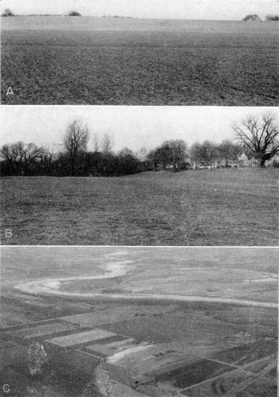
Figure 3--Transverse profiles of the Newman terrace and the flood plain.
Flood plain
The flood plain as mapped in this report (Pl. 1) contains many surface irregularities and minor scarps which may be interpreted as representing one or more minor terraces. Two factors give the impression of a. terrace younger than the Newman terrace. First, the point bar accretion slopes in abandoned meanders are so gentle that they appear horizontal and unless carefully surveyed could be easily mistaken for terraces (see the point bar accretion slope just south of Newman in Fig. 3). Second, it has been suggested that the radii of curvature of the meander scars have increased greatly during the last stages of floodplain development (Harbaugh, 1950). Arcuate point bar accretionary patterns and abandoned meander loops of varying radii can be differentiated on aerial photographs (Pl. 4C).
Kansas River between Kiro and Lawrence is actively cutting on only the south, or right, bank except at a few points. This may be due partially to the operation of Ferrel's law. A more reason-able explanation seems to be that the Wakarusa River basin intercepts most of the stream run-off south of Kansas River, and north of the river the streams are larger and more numerous. Thus the sediment supply from northern tributaries is much greater and produces a delta effect in the Kansas River channel which forces the river to the south. It is significant that the river shifts to the northern bluff line only opposite points at which large northward-flowing tributaries enter the channel. The northward loop of Kansas River at Topeka is the most notable example and is the reflection of the entrance of Shunganunga Creek.
Minor upland cycles of erosion
Two periods of alluviation and two periods of gullying are almost universally indicated in upland deposits. Bottoms of the oldest gullies are marked by local gravel accumulations and by an extremely well-developed soil zone. The oldest gullies are filled with 2 to 3 feet of black silt which has a weak central soil zone. Gullying in historical times has incised much deeper than formerly and has exposed the entire sequence to view. Gullies up to 20 feet in depth have developed in the soft till and terrace deposits. No effort was made to correlate these erosion cycles from one exposure to the next or to relate the upland cycles to changes in river erosion or alluviation.
Prev Page--Geography || Next Page--Geology
Kansas Geological Survey, Geology
Placed on web April 10, 2012; originally published June 1, 1952.
Comments to webadmin@kgs.ku.edu
The URL for this page is http://www.kgs.ku.edu/Publications/Bulletins/96_5/04_geom.html