Kansas Geological Survey, Bulletin 6, pt. 1, originally published in 1920
Next Page--Origin, migration, and production of oil and gas
Originally published in 1920 as Kansas Geological Survey Bulletin 6, part 1. This is, in general, the original text as published. The information has not been updated. An Acrobat PDF version (4 MB) is also available.
Dr. E. H. Lindley, Chancellor of the University of Kansas,
ex officio Director of the State Geological Survey:
Sir--The oil and gas resources of this state constitute one of its most important natural assets, the development of which in recent years has advanced remarkably. The amount of these fuels already produced places Kansas very high on the list of oil- and gas-producing states. In view of the rapidly increasing demand for oil and gas and the declining production from known fields, it is very important that undeveloped resources be found. Much of the state of Kansas is prospective or possible oil and gas territory, and the demand for authentic information concerning the oil and gas industry in Kansas, the possibilities of future development and the application of geological knowledge to the problems of increased production is constantly increasing.
It is proposed to issue the present report in parts, in order both to expedite the publication and to make readily available to citizens of the state information covering different phases of the subject and different portions of the state. The report will constitute Bulletin 6 of the Reports of the State Geological Survey of Kansas. Respectfully submitted.
Raymond C. Moore, State Geologist.
Petroleum1 and natural gas2 are naturally occurring materials of the greatest economic importance, which are widely, though not uniformly, distributed in the rocks of the earth. In some cases they are found under enormous pressures and in almost incredible quantities, but in general their occurrence is limited. At the present time so very great is man's use of petroleum and natural gas that they have become almost indispensable to him.
[1. Petroleum (Latin, petra, rock, and oleum, oil) in its widest sense embraces all of the hydrocarbons, gaseous, liquid, and solid, occurring in nature. The term is, in practice, limited to the liquid forms, and synonymous with the simple word "oil" so widely used by geologists and the industry in general.]
[2. Natural gas, as the term is applied, has come to have technical meaning, referring only to those gases occurring in rocks that are sufficiently inflammable to be used as a fuel or illuminant. Volcanic gases, or gases of the atmosphere, are also "natural," but are not included in the common use of the term.]
Composition. Even prior to the discovery of commercial quantities of petroleum, a number of determinations of its chemical composition were made. These analyses, supplemented by much recent investigation, show that petroleum consists of about 84 to 87 percent carbon and 11 to 13 percent hydrogen, with varying small proportions of sulfur, nitrogen, and oxygen.
| Ultimate Analyses of Petroleum3 | ||||||
|---|---|---|---|---|---|---|
| Locality | Specific gravity | Oxygen, Nitrogen |
Carbon | Hydrogen | Sulfur | |
| Regular | Baumé | |||||
| Pennsylvania | .816 | 39 | 82.0 | 14.8 | 3.2 | Trace |
| West Virginia | .841 | 36 | 84.3 | 14.1 | 1.6 | Trace |
| West Virginia | .873 | 30 | 83.5 | 13.3 | 3.2 | Trace |
| Pennsylvania | .886 | 28 | 84.9 | 13.7 | 1.4 | Trace |
| Ohio | .887 | 28 | 84.2 | 13.1 | 2.7 | Trace |
| Texas | .921 | 22 | 84.6 | 10.9 | 2.9 | 1.63 |
| California | .965 | 15 | 81.5 | 10.0 | 6.9 | .55 |
3. A chemical analysis showing the irreducible elements of which it is composed is known as an ultimate analysis. |
||||||
Hydrocarbons. The various hydrocarbons4 of which petroleum is chiefly composed, fall primarily into a regular series, in which a number (n) of hydrogen (H) atoms are combined with a given number (n) of carbon (C) atoms in the ratio indicated by the following series of generalized formulae:
| CnH2n+2 | Paraffin series |
| CnH2n | Olefine and naphthene series |
| CnH2n--2 | Acetylene series |
| CnH2n--4 | |
| CnH2n--6 | Benzene series |
| CnH2n--8 | |
| CnH2n--10 | |
| CnH2n--12 |
[4. The analysis of petroleum, which consists in the separation of its various components, and in their identification as hydrocarbons of definite constitution, is known as a proximate analysis. The exact nature of these, various hydrocarbon compounds, of which there are a very large number, is in most cases not easily determinable.]
The series represented in these formulae have all been recognized in petroleum. Each includes many members, the paraffin series, for example, beginning with marsh gas or methane, CH4, ranges at least as high as the compound C35H72. The lower members in this instance are gaseous, the middle members are liquids, with regularly increasing boiling points, and the higher members are solids, like ordinary paraffin. Gaseous and solid hydrocarbons that are present in petroleum are in solution. The paraffins5, are found in all crude oils, in many cases composing the largest proportion of the oil. The olefine series occurs in the majority of petroleums and is important in a few. The acetylene series is represented in some petroleum, notably that from the Baku district of Russia. Members of the benzene series, especially benzene and toluene, occur in all petroleums, but not in large amounts. Certain crude oils have been found to contain camphenes, napthalenes, and other so-called aromatic hydrocarbons.
[5. Petroleum, which contains chiefly the paraffin hydrocarbon series and which yields paraffin when the heavier distillates are subjected to a freezing temperature, is said to have a paraffin base. Crude oils, which upon evaporation yield a residue consisting essentially of asphalt, are said to have an asphaltic base. Some oils, including representative midcontinent samples, have both paraffin and asphaltic bases.]
Impurities. Sulfur may be present in crude petroleum either as free sulfur, as a constituent of hydrogen sulfide, or as an organic sulfur compound. Petroleum entirely free from sulfur is extremely rare, but the amount of this constituent is commonly very small. Most petroleum contains some nitrogen, but it rarely exceeds 2 percent. In most cases it exists in the form of complex organic compounds. Small amounts of oxidized materials, as complex acids and phenols, are found in some oils.
Color. Most crude oils are opaque by transmitted light except in very thin layers. Many of the lighter grades, however, notably certain oils from Pennsylvania, Wyoming, and Alberta, range in color from a pale straw yellow, through red and brown, to dark green. By reflected light most crude oils have a greenish cast.
Refractive Index. Of scientific interest and technical importance is the effect exerted by petroleum on light rays that are passed through it. Thus, the refractive index has significance regarding the origin of various petroleums, and may be used in their identification. It is observed, also, that certain crude oils and their distillates rotate slightly the plane of polarized light, the direction of rotation being in general to the right.
Odor. The odor of certain crude oils is very characteristic. The oils from Pennsylvania and parts of the midcontinent region have the odor of gasoline. Much of the Texas and Mexican oil has the disagreeable odor of hydrogen sulfide.
Specific gravity. One of the important physical properties of petroleum, affording the basis of a rough classification that may be correlated with the proportion of more valuable light oils contained, is specific gravity. Crude oils show an extreme range in specific gravity from .771 to 1.060, the average being between .800 and .980.
The specific gravity of any substance is the relation it bears by weight to the same volume of water. Water has a specific gravity of 1. Most petroleums are lighter than water, and hence have a specific gravity less than 1, the amount being commonly expressed in decimals, as .850, for average Kansas oil. For the measurement of the specific gravity of fluids, such as oil, a thermometer and a hydrometer are used. The hydrometer is a glass tube, enlarged and weighted at the lower end, so that when placed in a fluid it will float upright, being submerged to an amount depending on the relative weight or buoyancy of the fluid. The upper part of the tube is marked with graduations from which may be determined the amount of submergence, and from this the relative weight or specific gravity of the fluid. The scale commonly used is that devised by a French chemist Antoine Baumé in 1768, and after him known as the Baumé scale. A specific gravity of 1, compared with water, is arbitrarily chosen as 10° on the Baumé scale. Ordinary specific gravity determinations may be converted to the Baumé scale by dividing 140 by the specific gravity and subtracting 130; Baumé degrees may be converted to specific gravity by dividing 140 by degrees Baumé and adding 130. Thus a heavy oil has a low gravity in Baumé degrees, and a light oil a high one. Though the Baumé scale has no marked advantage over the rational scale, the refiner and the oil trade have adhered to its use through custom.
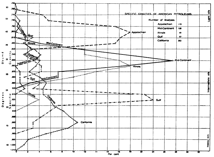
The specific gravity of crude oils from the fields of the United States is shown in plate 1. It will be observed that average midcontinent petroleum has a specific gravity of .850, or 35° Baumé, and that more than 90 percent of the oils tested from this field have a specific gravity between .875 and .825, or 30° and 40° Baumé. Average Pennsylvania (Appalachian) crude oils, which are relatively very light, have a specific gravity of .800 or 45° Baumé. Petroleum from Texas and Louisiana (Gulf region) have an average specific gravity of about 23° Baumé and those from California as low as 16° Baumé, though some of the California oils also are light.
Plate 1 Specific Gravities of American Petroleums---Available determinations of the specific gravity of crude oils from each field have been separately computed to 100 percent for that field. Thus plotted they are directly comparable and show clearly the general average and the range of the crude oils of each field. About 27 percent of the oils rereported from the Midcontinent field have a specific gravity of 0.850, or 35° Baumé. Nearly 11 percent of California petroleums have a specific gravity of 0.960, of 16° Baumé, but the oils from this state range from 1.010 to 0.750. (Data from Mineral Resources, 1913, U. S. Geological Survey, p. 1,126-1,265.)
Expansion. Changes of temperature produce a slight but variable change in the volume of petroleum. The coefficient of expansion of petroleums is important for determining the expansion space to be allowed in storage vessels and for transport. Observation shows that the coefficient of expansion decreases as the specific gravity rises. Thus a light oil has a high coefficient of expansion and a heavy oil a low one.
Viscosity. The viscosity of petroleums, the resistance offered to flow, like the specific gravity, shows a considerable range. Indeed, a somewhat direct relation appears to exist between these properties, certain of the very light paraffin oils being remarkably fluid and the heavier asphaltic oils showing an increase of viscosity with specific gravity. Temperature, however, has an important effect on the viscosity of petroleum. The viscosity of crude oil is an important character because it determines the facility with which it may be pumped through pipelines. Some oils flow with such reluctance that they must be heated before they can be pumped. The heavy oils with high viscosity can be transported by pipeline only in the warm summer months. Crude petroleum solidifies when cooled to a temperature varying from 82° F in the case of some Burma oils, to several degrees below zero in certain very light Italian oils.
Flashing point. The flashing point, or the lowest temperature at which inflammable vapors are given off, is a matter of concern in the case of certain oils. It has an extreme variation, from below zero in the Italian oils to more than 300° F in certain oils from Africa.
Boiling point. The boiling points of petroleums and the distillates obtained at specified temperatures differ very considerably, also, in the crude oils obtained from different sources. Distillation begins at lower temperatures in the lighter oils and at higher temperatures in the heavier oils.
Heating value. The heating or calorific value of crude petroleum is an important character, especially in view of the rapid increase in the use of crude oil and residues for fuel in steam plants, and railway and marine engines. Some of the very heavy crude oils are used almost entirely for fuel and compete to advantage with coal. Many of the lighter, high-grade petroleums, after partial distillation, also furnish a residue which is sold as fuel. The average heating value of crude petroleum from the midcontinent field is about 10,900 calories6 or 19,600 B.T.U. Good average coal has a heating value of about 7,500 calories, or 13,500 B.T.U.
[6. A calorie is the heat required to raise the temperature of 1 gram of water 1° Centigrade. The British thermal unit (B.T. U.) is the pound-degree or the amount of heat required to raise a pound of water 1° Fahrenheit.]
Composition. Natural gas contains only the lightest and most volatile of the hydrocarbons. It consists chiefly of the lower members of the paraffin series, especially marsh gas, or methane, which has the chemical formula CH4. Ethane (C2H6) is present in considerable quantities in the natural gas from some regions. In association with these hydrocarbons there may be varying quantities of carbon dioxide (CO2), carbon monoxide (CO), hydrogen sulfide (H2S), hydrogen, oxygen, and nitrogen. Some of the natural gas from Kansas is of more than usual interest because of its remarkably high nitrogen content, a sample from Dexter, Cowley County, containing 82.7 percent of this element. Helium, to more than 2 percent, argon, and the rare element neon, have been discovered in the natural gas of Kansas.
| Analyses of Average Gas from Various Kansas Fields | |||||
|---|---|---|---|---|---|
| Locality | Carbon dioxide CO2 |
Oxygen O2 |
Methane CH4 |
Ethane C2H6 |
Residue |
| Allen County | 2.22 | .34 | 90.62 | 3.67 | 3.25 |
| Arkansas City | .07 | .24 | 65.63 | 15.30 | 18.76 |
| Augusta | .23 | .34 | 68.75 | 15.46 | 15.22 |
| Montgomery | .90 | .22 | 85.91 | 9.12 | 3.85 |
| Winfield | .12 | .61 | 71.77 | 10.75 | 16.75 |
There are two general types of natural gas: (1) "dry" gas, which consists principally of methane (CH4) with a small content of ethane (C2H6) and nitrogen, and (2) "wet" or casing-head gas, which contains beside methane varying amounts of the heavier hydrocarbons. The dry gas is the chief type produced in most localities. It does not contain any appreciable amount of readily condensible gasoline and is not usually closely associated with petroleum. Wet or casing-head gas contains condensible gasoline. It is characteristically associated with petroleum and is yielded with the oil in many wells. It also comes from the gas wells in oil pools, producing from the oil-containing strata.
Although natural gas is somewhat closely related chemically to petroleum, its physical properties are very different. Of first importance, of course, is the gaseous character of its constituent hydrocarbons, which necessitates methods of handling commercially quite different from those used in oil production. The gas is colorless, practically odorless, and burns with a luminous flame. When mixed with air, it is highly explosive.
In heating value, natural gas varies considerably, depending on the chemical character and proportion of its combustible hydrocarbons and the relative quantities which are present of such incombustible impurities as nitrogen. The heating value of natural gas is high, as shown by numerous tests. Dry gas has a value amounting to about 525 calories or 950 B.T.U. per cubic foot. Thus about 135 cubic feet of natural gas is equivalent in heating value to one gallon of average midcontinent fuel oil. Casing-head gas may have a heating value as high as 2,500 B.T.U. and rarely falls lower than 1,000 B.T.U. Natural gas has a much higher heating value than manufactured gases. In many respects it may be regarded as an ideal fuel because of its cleanness, ease of handling, efficiency of combustion, and low content of poisonous constituents.
Petroleum is found in many parts of the world and under a variety of geological conditions. Observations concerning its distribution guide the search for new deposits and assist in the efficient development of known fields. A summary of these observations may be presented here as an introduction to the more detailed consideration of the occurrence of oil in the succeeding chapters.
Plate II--Map showing distribution of oil in world.

There is hardly a country in the world in which petroleum, in large or small quantity, has not been found. It is known both in high latitudes and in the tropics, in the eastern hemisphere and in the western, on islands and on the continents. Oil has been found in lofty plateaus and mountain ranges; it is also known very deeply below the level of the sea. There appears to be no simple limiting factor of a geographic nature in the distribution of petroleum.
The occurrence of oil is by no means uniform, however. In some places it is concentrated in enormous quantities and under very great pressures. In other places the quantity of oil is so small, or it is so disseminated and so difficult to extract that at least under present conditions, the deposit cannot be regarded as of commercial importance.
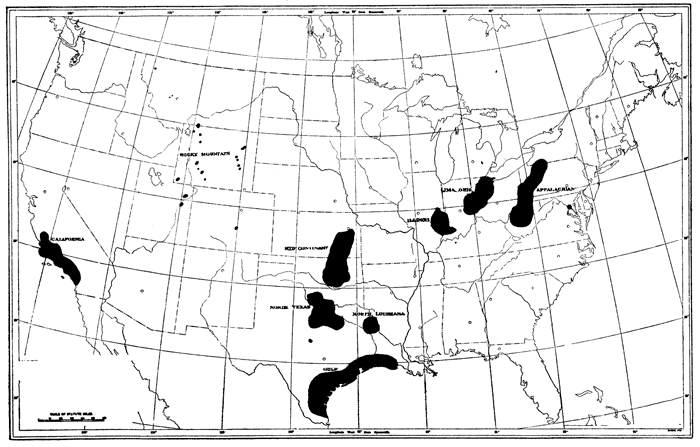
Oil fields and districts. In any given oil-containing region, as for example the Mississippi Valley in the United States, it may be observed that the commercially valuable accumulations are restricted to certain relatively small parts of the general region. These are conveniently known as oil "fields." The midcontinent field, comprising parts of Kansas, Oklahoma, and northern Texas, and the Lima-Indiana field, which includes portions of eastern Indiana and western Ohio, are examples. Much the greatest portion of the Mississippi Valley region is not included in any of the oil fields.
Detailed maps of any of the so-called oil fields shows that the oil comes chiefly from rather small areas, which are separated by unproductive territory. These more or less isolated areas of large production are commonly known as "pools" or districts. The El Dorado district, in Kansas, and the Cushing district, in Oklahoma, are such very productive areas or pools in the midcontinent field. They are separated from other parts of the field by unproductive territory. (See Map Kansas Oil Field, Part III.)
Finally, it is to be observed that within a given oil-producing district or pool there may be spots where there is no commercial production. This is especially true in some of the midcontinent oil districts.
Plate III--Map of United States, showing "oil fields."
Depth. Oil comes naturally to the surface in some localities in springs and seepages. Beneath the surface of the earth it is found in some places at very shallow depths, but in others at depths of as much as 1 mile. The oil obtained in the discovery well drilled by Drake in 1859 was found at a depth of 69 feet. A well recently drilled in West Virginia, not far distant from the first American oil well, reached a depth of 7,579 feet7 but did not succeed in attaining the oil- and gas-bearing horizon that it was intended to test. Probably the lower limit of important quantities of oil is not more than 1 mile; for at great depths the pore space in the rocks is reduced by compacting due to the weight of overlying rocks. The greatest deposits of commercially available oil are found at intermediate depths, that is, more than 1,000 feet and less than 3,000 or 3,500 feet. In the zone near the surface there is maximum possibility of the dissipation of oil accumulations through fracturing and erosion. In some districts, or even in individual wells, oil is obtained from several horizons that may be separated by several hundred feet of unproductive strata. Apparently depth is not a controlling factor in the formation of an oil deposit of commercial value, though it is a very important factor in the cost of development. Oil may be encountered at almost any depth down to 1 mile or perhaps more.
[7. Lake well No. 1, Hope Natural Gas Company.]
Lithologic character. In small quantities, oil has been found in almost all kinds of rocks. In some, however, the occurrence is very evidently the result of special geologic conditions and is not of commercial importance. Valuable accumulations of oil are confined to sedimentary rocks. This is due to the facts that the oil apparently originates in the sedimentary rocks and that in certain of them is found the requisite porosity. Sand and sandstone, which are commonly the most porous sedimentary rocks, are the most important containers of commercially available oil deposits. So general, indeed, is the association of oil production with sands or sandstone that in practice almost any rock from which oil is obtained in a well is known as a "sand." In some fields considerable amounts of oil have been obtained from porous, fractured or water-channeled limestone8 and from fissured shale.9
[8. Lima-Indiana field, and Mexican fields.]
[9. Florence and Boulder fields, Colorado; Gaines pool, Pennsylvania.]
Geologic age. The known oil deposits are not confined to the rocks of any particular geologic age. About 57 percent of the world's total production, however, comes from Tertiary strata, and more than 25 percent from the Carboniferous. The remainder comes chiefly from the Cretaceous, Devonian, and Ordovician. The chief Tertiary fields in North America are those in California, Texas, Louisiana, and Mexico. All of the important foreign oil fields, those of Russia, Roumania, Galicia, Dutch East Indies, Peru, and Trinidad, produce from Tertiary formations. The commercial production of petroleum from Paleozoic rocks is confined to the North American continent. In the midcontinent field the oil is obtained from the Pennsylvanian, in the Appalachian field from Devonian and Mississippian beds, and in the Lima-Indiana field from the Ordovician. Production in Illinois is obtained from the Mississippian. In New York and Ontario, oil has been obtained from the Devonian and Silurian. The chief Cretaceous fields are those in Wyoming, Colorado, Gulf Coast region, and Mexico.
Figure 1--Diagram showing the distribution of oil produced in the United States by geologic periods.
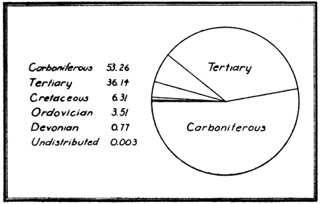
The absence of important production from Permian, Triassic, and Jurassic rocks is doubtless due to lack of original organic material in the case of these formations in North America, but in other parts of the world where they are at least in part abundantly filled with organic matter, it is possibly due to lack of exploration and development.
Structure. Study of the geologic conditions associated with large accumulations of petroleum in the known oil fields of the world indicates that there is an important relation between the occurrence of the oil and the position or structure of the rocks which contain them. The oil is found, in most cases, in the upper part of the porous containing rock; if gas is present, also, immediately beneath the gas. Saltwater, which is commonly associated with the oil, occurs beneath the oil.
The position of the oil accumulation appears to depend primarily on the shape and position of the containing porous rock or reservoir. In some cases, especially if the reservoir is lenticular in shape, commercially important deposits are found in strata, which are essentially horizontal or inclined in one direction. Most commonly, however, large amounts of oil are found where the containing rock has been arched in such a manner that one portion is higher than other parts. These structures, anticlines, domes, and terraces, which are most favorable for important accumulations of oil, it is largely the work of the geologist to determine.
There are many kinds of rocks, but only a few are likely to contain important quantities of oil or gas or to be associated with such deposits. One who seeks in a scientific manner to find and develop the natural accumulations of oil and gas which occur in the earth must understand the essential characters of the rocks which are associated with them.
Based on their mode of origin, three main classes of rocks are commonly recognized by geologists. These are (1) igneous rocks, which have been formed by the cooling and solidification of a lava or magma, (2) sedimentary rocks, which have been formed, chiefly under water, of particles derived by mechanical or chemical agents from previously existing rocks, and (3) metamorphic rocks, which have been formed from igneous or sedimentary rocks by alteration (due chiefly to heat and pressure) which has partly or wholly obscured their original characters.
Igneous and metamorphic rocks which are frequently classed together as crystalline rocks, are, in general, quite compact and rather hard. In practically no cases have they been found to contain important deposits of oil or gas. This is due both to their low porosity and to the unfavorable conditions for the formation of oil or gas in such rocks.
Igneous rocks include (1) solidified lavas of all sorts which have been poured out on the earth's surface from volcanoes or other vents, and (2) magmas which have cooled and hardened below the surface. The former comprise the extrusive rocks such as basalt, rhyolite, volcanic tuff, ash, and scoria.
No typical surface igneous rocks are known in Kansas, but beds of volcanic ash are known in Phillips, Norton, Meade, and Harper counties. Lava-capped mesas occur a short distance outside the state in southeastern Colorado.
The latter include dike and vein rocks, which are in general characterized by a porphyritic texture, and the deep-seated, coarse-grained rocks that crystallized deep below the surface of the earth. The last mentioned, represented by such well-known rocks as granite, are exposed at the surface only after long erosion.
A single very small outcrop of igneous rock, a dark-colored basic rock, has recently been found in Riley County,10 but elsewhere in Kansas the igneous rocks do not appear at the surface. Crystalline rocks, chiefly granite, underlie all of Kansas and in the central part of the state rise to within a relatively short distance of the surface, a fact which has had a very important bearing on the search for oil and gas and probably also on the formation of the important commercial accumulations of this region.
[10. Moore, Raymond C., and Haynes, Winthrop P., Outcrop of Basic Igneous Rock in North-central Kansas, Bulletin, American Association of Petroleum Geologists, v. 4, 1920.]
Metamorphic rocks are in some cases developed locally as from the heating and chemical alteration produced by ascending lava or heated waters, or they may be formed over a considerable region by great pressure and heat that affect a large area. Metamorphic rocks of the first class have been observed south of Yates Center, Woodson County, at the very old mining camp called Silver City, now abandoned. Since the heat and pressures which are associated with the making of metamorphic rocks are so great that any oil or gas that may originally have been present has been driven off, these substances are never found in association with metamorphic rocks except in unimportant cases where the accumulation is certainly secondary.
The character of sedimentary rocks depends on the nature of the material from which they are formed and the degree of consolidation or compacting which it has assumed. Four chief types of sediment, to which correspond four main types of sedimentary rocks, are commonly recognized.
| Sediment | Compacted Rock |
|---|---|
| Gravel. | Conglomerate. |
| Sand. | Sandstone. |
| Silt and clay. | Shale. |
| Lime deposits. | Limestone. |
Conglomerate. Unconsolidated aggregates of more or less rounded or water-worn pebbles are called gravel. The gravel may be deposited by a stream or accumulated along a lake or sea beach by the action of the waves. When the pebbles are cemented together into a coherent rock, it is called conglomerate. Silica, calcite, and limonite are the principal cements that bind the particles together.
There are beds of conglomerate in various parts of Kansas, but none are very thick. The most widespread are the so-called "mortar beds," which are found at or near the surface over a large part of western Kansas. The gravel was brought eastward from the Rocky Mountain region by streams that flowed across this part of the state in the Tertiary geologic period. The cementing material of these conglomerates is lime carbonate. In places the gravel grades into coarse, or even fine sand, in which cases the rock would properly be termed a sandstone. Some of the oil-producing horizons in the Peabody-Elbing field are conglomerates.
Sandstone. Sand consists of rather small, rounded or angular rock particles that are most resistant to the effects of weathering and erosion. Most sand is composed largely of grains of quartz. Sands that have been consolidated are known as sandstones. In most sandstones the grains are bound together by cementing material, but in some there is little if any cement, the grains being held together by the pressure to which they have been subjected. According to the strength and the amount of cement, sandstone is hard and firm, or soft and friable. The cementing materials in sandstones are commonly silica, iron oxide, calcite, or clay. Sandstones are generally very porous rocks. In some cases the porosity is as much as 30 percent, but where the interspaces between the grains are filled with cement or fine clay, the porosity is very much reduced. The texture of sandstones is commonly rather even. If the grains are large, the rock is coarse; if very small, fine grained, and therefore may contain large quantities of water, oil, or other fluid.
There are numerous sandstone beds in Kansas, some of them 100 to 150 feet thick, or even more. In eastern Kansas the sandstones occur in association with limestones and shales which belong to the Pennsylvanian system. In many instances they contain large amounts of oil and gas. In Montgomery, Chautauqua, and other counties of the southeastern part of the state, sandstones are especially common. The topography is locally very rough and broken, due to the resistance of these massive sandstone beds to weathering. The sandy soil which is formed in sandstone districts supports a thick cover of scrub oak. In the south central part of Kansas, including especially Sumner, Barber, Comanche, and Clark counties, there are extensive exposures of red sandstones which belong to the upper Permian. No oil or gas has been found in these sandstones or beneath the surface here. One of the most widespread and well-known sandstone formations in the state is the Dakota sandstone of Cretaceous age, which appears in a very irregular band extending from the north state line in Washington County southwestward to the extreme west and south parts of Kansas. This sandstone, light to very dark brown in color on account of an abundance of iron oxide cement, has a total thickness of more than 200 feet. It extends continuously beneath western Kansas and eastern Colorado, appearing at the surface just east of the Front Range of the Rocky Mountains. It is a very porous rock and carries a large volume of water from Colorado downward and eastward underground into Kansas. The water appears as springs along the outcrop of the Dakota sandstone in Kansas, and in wells which have been drilled into the rock. No oil or gas has been reported from the Dakota sandstone.
Shale. Muds and clays, which consist of exceedingly fine particles of mineral matter of various sorts, when compacted are known as shale. As in the case of sandstones and conglomerate, the particles may be held together by cement, but most commonly they are packed together simply by the pressure to which they have been subjected. Consequently, shales are in general rather soft rocks, can be cut with a knife and are apt to be brittle, readily breaking into little chips. They exhibit a much more distinct stratification or bedding than sandstones or conglomerates and may commonly split very readily along the thin bedding planes. Shales have a variety of colors from light to dark. Yellow, brown, gray, drab, and black are common colors observed. Oil is found in many shale beds, but in most cases not in sufficient quantities to be of commercial value. Some of the oil-bearing shales from Colorado and adjacent areas to the northwest are so impregnated with hydrocarbons that they may be readily ignited. Unlike sandstone, shales tend to be impermeable to water. Owing to the soft soapy feeling of many deposits of weathered shale the name "soapstone" has been locally incorrectly applied.
There is no part of Kansas in which deposits of shale do not occur at or near the surface. This type of rock, indeed, constitutes approximately 80 per cent of all the sedimentary rocks, from the standpoint of quantity. In eastern Kansas the shale occurs between the limestones, which make more or less prominent escarpments across the state. The thickest of these shale formations is the Cherokee shale, which appears at the surface in Labette, Cherokee, and Crawford counties in the extreme southeastern part of the state. Much of the Permian also is shale, the Wellington formation which outcrops in a broad belt across central Kansas from north to south consisting almost entirely of shale. The Benton division of the Cretaceous is largely composed of shale. The largest single formation of shale in the state is the Pierre shale of upper Cretaceous age, which appears at the surface in the northwestern counties of Kansas. It has a thickness of at least 1,200 feet.
On account of its softness and numerous thin bedding planes, shale breaks down very readily under the action of the weather and forms a soil which ordinarily bears a thick cover of vegetation. The stratified shale is therefore effectually concealed, and good exposures are very unusual. The presence of a shale formation immediately below the surface is commonly marked by smooth slopes or gently rolling topography, for the rock is not sufficiently resistant to erosion to form a prominent feature of the landscape.
Limestone. Limestones are rocks that consist essentially of lime carbonate. Almost all contain more or less impurities such as clay and siliceous matter, those which contain appreciable proportions of magnesium carbonate being known as magnesian limestones or dolomites. Limestones may be fine or coarse grained, hard and brittle or soft and chalky, massive or thin-bedded, and of almost any color. The most common colors are light or drab gray, yellow, or brown. The limestones may be distinguished from other rocks that they resemble by the readiness with which they can be scratched or cut, and by the rather brisk effervescence which is exhibited when they are treated with acid. Limestones are not sufficiently porous in most instances to be of much importance as containers of oil or gas, but some of the limestones of eastern Kansas, notably the Fort Scott ("Oswego") limestone, and the Mississippian limestone in Osage and Kay counties, Oklahoma, and possibly in central southern Kansas, contain important deposits of these materials.
Limestones are apparently much the most widespread and common rock type in Kansas, especially in the eastern part of the state. Beds of limestone, some of them thick, others thin, are found at intervals from the Mississippian almost to the top of the lower Permian, and in the Benton and Niobrara divisions of the Cretaceous. The Mississippian and Niobrara are almost wholly made up of limestone. Quantitatively the limestones are not as important as the shales, but on account of their resistance to weathering and erosion, the limestone beds form more or less prominent escarpments and flat-topped hills. These are the most outstanding topographic features of many parts of the state.
Flint and chert. Flint is a dark gray to black, very hard and compact mass of silica which occurs in irregular nodules and beds in limestone or chalk. Chert, commonly light gray or white in color, is an impure variety of flint which is very abundant in some limestones, as in the Mississippian of the midcontinent region. Both flint and chert are very hard, and although they are brittle and tend to break in sharp-angled fragments, it is extremely difficult to drill through them.
Gradations. All sedimentary rocks are by no means referable to clearly defined examples of one or other of these four main types. Just as some muds are sandy, or sands muddy or gravelly, there are gradations between the main kinds of sedimentary rocks. Thus shales may be sandy (arenaceous) or limy (calcareous), sandstones shaly (argillaceous) or limy, and limestones shaly or sandy. A rock composed of nearly equal amounts of sand and clay might be regarded either as a very sandy shale or a very shaly sandstone.
Any natural accumulation of gravel, sand, clay, or lime is potentially a sedimentary rock. The geologic agents which make or assist in making such accumulations are the wind, streams, glaciers, lakes, and the oceans. Deposition of the materials which later by pressure and cementation become rocks takes place wherever winds, streams, or currents can no longer transport them.
Because the velocity, and therefore the transporting energy of winds, streams, and lake or ocean currents is by no means constant, the amount and size of the materials which are transported under different conditions and at different times varies. A strong current may move coarse and relatively heavy particles, such as pebbles, but a gentle current may be able to move only very small particles, as clay. A natural assortment of the materials is thus effected, coarse sediment, as gravel or sand, being deposited in one place, fine sediment, as clay or lime mud, in another. Under changing conditions a layer of fine sediment may be deposited upon coarser material, and coarse, in turn, on fine. The deposition of sediments in layers in this manner is termed stratification. From the nature of their origin, sedimentary rocks are, typically, stratified rocks, though some rocks, as shales, are much more perfectly and finely stratified than others, as sandstones and conglomerates. The planes of division between layers of rock are known as bedding planes. Not only is each accumulation of one kind of sediment more or less finely stratified, but the deposition of other kinds in succession upon the first forms a stratification of a larger order. Thus, a formation of limestone may overlie shale, which in turn rests upon sandstone. Sedimentary rocks are well known, therefore, as stratified rocks.
Where particles of sediment are deposited on an inclined surface, as on the lee side of a dune or bar, the fine lines of stratification incline at the angle of the slope. Since this inclined bedding is not parallel to the main stratification of the formation, it is known as false bedding or crossbedding. Crossbedding is chiefly observed in sandstones. It may be developed in sands deposited by the wind, streams, or lake and ocean currents. The Dakota sandstone in Kansas is locally very much crossbedded.
On the basis of the place of deposition, sedimentary rocks may be divided broadly into (1) continental deposits and (2) marine deposits.
Continental deposits are those laid down on the lands (a) by the winds, (b) by streams, (c) by glaciers, and (d) in lakes or swamps. They are as a whole characterized by the absence of marine fossils and for the most part by irregularity of distribution, thickness, and stratification. Apparently their importance in relation to the production of oil or gas is almost entirely negative, for the conditions which seem to be requisite for the formation of oil and gas are generally lacking. Accumulations of these hydrocarbons, which in some instances have been found in deposits of continental origin, are probably derived from adjacent marine deposits. The "red beds" of upper Permian age, the Tertiary, and at least a part of the Dakota sandstone in Kansas, are evidently continental deposits. As indicated by coal beds and very numerous land-plant fossils in the Pennsylvanian and lower Permian, there is evidence that parts of these beds were land deposited.
Marine deposits are those formed in the sea. Such deposits are now being made along the borders of the continents, the materials coming primarily from streams which dump their load of sediment and dissolved rock materials into the sea, and from the work of waves which are eroding the lands. In the geologic past it is apparent that much of the present continents has at various times been submerged by the sea, for marine deposits are very widespread on the lands. In general, they are characterized by the presence of marine fossils and by the wide distribution and comparative uniformity of character of individual formations. Petroleum and natural gas are so characteristically associated with marine deposits that it seems certain the former is genetically related to the latter. Marine sedimentary rocks are therefore of utmost importance to the student of oil and gas deposits. Most of the sedimentary rocks of Kansas are marine. They include the Mississippian and older Paleozoic rocks not exposed at the surface in the state, and all but a small portion of the Pennsylvanian, lower Permian, and Cretaceous.
The important geologic characters of sedimentary rock formation are (1) lithologic character, (2) distribution and thickness, (3) fossils, (4) relation to other rocks, and (5) structure.
The geological unit among sedimentary rocks is a formation. This may be defined as a sedimentary deposit having more or less similarity in lithologic character and fossils readily identifiable and capable of representation on a geologic map. It should be a practically useful, as well as a natural division of the rocks. Since sedimentary rocks of a given type are in many instances graded both vertically and laterally into a different type, it is in these cases difficult to identify satisfactory lines of division. Consequently, while in most cases a geologic formation consists chiefly of a single rock type, some formations are composed of a succession of different rock types. Where geologic formations are clearly differentiated by individual distinguishing characters, they are very readily recognizable. However, in such a series of stratified rocks as those of eastern Kansas, which consist of alternating deposits of limestone, sandstone, and shale, variable in thickness and extent, and with more or less similar fossil content, formations have not been defined in identical manner by all workers--a fact which has caused some confusion in the geologic study of this region.
Separately identifiable and traceable parts of a geologic formation are in some cases distinguished and named as members. The Oread limestone member is a prominent portion of the Douglas formation. In a few instances (in regions where detailed geologic studies have been made) the parts of a member may be separately designated as beds. For instance, the Oread limestone member consists of the upper, middle, and lower limestone beds, which are separated by shale beds.
Formations are in some cases grouped together in larger units known as series. All the rock formations of a series must be related in geologic age and generally represent the deposits of a single epoch of submergence of the land by the sea.
The deposits made during the larger periods of geologic time are known as systems.
Geologic names. The names that are given to geologic formations are derived from a geographic feature--river, creek, hill, mountain, town, or county--in the vicinity of which they are typically developed. By agreement the same name may not be used for different formations and the first name properly applied to a formation has priority over names that later may have been employed.
The composition, texture, color, and peculiarities of stratification or other features which distinguish a sedimentary rock formation may be described under the head of lithologic character. While this is not entirely constant in all parts of a formation, it is a very important and in most cases a consistent distinguishing feature. Thus the Dakota sandstone of Cretaceous age is in general very readily identifiable on the basis of its lithologic character. It is a brown, rather coarse-grained, massive, extensively crossbedded and very ferruginous formation, quite unlike most of the other sandstones of the state in appearance. Careful study of lithologic characters may indicate clearly the source of the material in the formation, the general position of old shore lines, and other important geologic information.
The geographic distribution and the thickness of a formation are matters of geologic significance, since they show the space relations of the formation. All rock formations are typically more or less lenticular in shape, the detailed character of which depends partly on conditions of deposition, and partly, in some cases, on subsequent erosion. A formation of approximately uniform thickness and wide distribution, like most marine limestones, is a reliable datum in the determination of rock structure. A local deposit of very irregular thickness is not a desirable datum. Oil sands are commonly lenticular and more extensive in one direction than another. It is consequently important to know as definitely as possible the horizontal extent and the thickness of the sand.
Distinguishing markers of different formations are the fossils they contain. Fossils are the remains or traces of animals or plants that are found in the rocks. Some formations are much more fossiliferous than others, which may be in itself a distinguishing feature; but it has been found that the fossils of one formation are different either in kind or in associations from those in other formations. There are great differences, which are readily evident to the trained geologist, between the fossils contained in formations of different geological ages. This, of course, is a very important aid in the identification of formations and in determining the geological conditions in any area. The fossils found in marine formations are chiefly marine invertebrates and in some cases vertebrates such as fishes and reptiles; those commonly found in continental deposits are freshwater vertebrates and invertebrates, and land plants. Continental deposits are in general much less fossiliferous than marine deposits.
The relation of one rock formation to others with which it is in contact is especially important to the petroleum geologist. This relation is the result of the geologic conditions and history of the region in which the formation occurs. When the sea is gradually encroaching on the land each succeeding formation has a wider distribution than those preceding. The formations then overlap. Many such overlapping series are known. In a continuous series of deposits one formation is normally laid down more or less evenly and regularly upon another, and each succeeding formation is, of course, later or younger in age than those previously deposited. The distinctions between such deposits are the lithologic character, fossils, thickness, and perhaps distribution, where a formation is in contact at its base with any rock formation which may chance to underlie it. If a land area composed of various sorts of rocks should be submerged by the sea, the deposit laid down in the sea would cover all the different rocks.
Laterally one rock formation may grade into another of different lithologic character and slightly different fossils, though of essentially the same geologic age. Indeed, this is the normal rather than the exceptional relation, for there is not a sharp line of division between gravel and sand, sand and clay, or clay and lime. Coarse sediments dropped by currents near the shore grade into finer sediments off shore. Consequently a sandstone formation may grade laterally into shale or shale into limestone.
Normally, rock strata are laid down in essentially parallel position, the younger beds regularly succeeding the older. If the deposition of sediment is interrupted, as when the sea is withdrawn from the continent and erosion of the recently formed rock intervenes, not only will there be a gap in the series of deposits, but, especially if the strata are tilted or folded during the change and are beveled off by erosion, the line of contact between the old rocks and those which are later deposited marks a break in the sequence of deposits. The younger beds do not conform to the older and the line of contact is known as an unconformity. Unconformities are important in their relation to oil and gas accumulations. Formations that unconformably overlie older beds conceal the structure of the latter.
Sedimentary rocks are originally deposited in a position that is horizontal or nearly so, and the layers or strata are essentially parallel. As a result of warping or folding which has taken place since the time of their deposition; however, the strata may have almost any angle or direction of inclination, in some places even standing in a vertical position. Steep inclinations are commonly found only in mountain areas. The slope of the rock strata in most of Kansas and the midcontinent region is very slight, being measurable only in feet per mile.
Dip and strike. The inclination or slope of rock strata is expressed geologically in terms of dip and strike. Dip is the maximum angle of slope of a bed from the horizontal. It varies from 0°, for a horizontal bed, to 90° for those which stand upright. Strike is the bearing of the line of intersection of a horizontal plane and the sloping plane of a stratum. The direction of strike is expressed in compass bearings as north 80° west (N 80° W). The directions of dip and strike are at right angles to each other. Dip and strike are frequently represented on maps by a T-shaped symbol, in which the upright leg marks the dip and the top the strike. The symbol is so placed on the map that the direction of the strike and dip is indicated by the position of the T, and since the dip line of the symbol does not show the amount of the dip, this is commonly indicated by the proper figure.
Folds. While rock strata are in some places found essentially in their original position, that is, horizontal or with a very slight initial inclination, in most cases they have been tilted, warped or folded. The resulting structures are simple or complex, depending on the nature of the deformation. (1) Horizontal strata have no dip. Such a structure is technically an acline (a [no] cline [dip]). There are no true aclines of large size. (2) Where beds are tilted in a single direction the structure is termed homocline (homo [uniform] cline [dip]). A homocline may be gentle and with nearly uniform inclination, or it may be steep and marked by variations in the degree of inclination. (3) Where strata are lifted into an arch or up-fold, the structure is termed an anticline (anti [opposing] cline [dip]). The sloping sides (limbs) of an anticline may be steep or gentle, nearly equal in slope (symmetrical) or quite unequal (unsymmetrical), and the flexure at the crest sharp, like the top of a gable roof, or evenly rounded. The crest, or highest part of an anticline (axis), may trend in a fairly straight line or it may change in direction. It may be approximately the same in elevation along its course, or irregularly plunging. An anticline in which the rocks dip in all directions from some point is termed a dome. Domes may be rounded, like an inverted saucer, or very irregular in shape. (4) Where the strata are downfolded into a trough-like structure the fold is known as a syncline (syn [uniting] cline [dip]). Like anticlines, synclines may be steep or gentle-sided, symmetrical or asymmetrical, and with axes nearly horizontal or plunging. Where the rocks dip downward from all sides toward a common point, forming a saucer-like depression, the syncline is termed a rock basin.
In size, folds vary from almost microscopic wrinkles to immense structures many miles in width and embracing thousands of feet of rock strata. Folds vary in complexity from extremely slight warpings, which require careful instrumental measurements to detect, to the bewilderingly intricate, crumpled folds of some mountain regions where it is exceedingly difficult, if at all possible, to trace a given bed any distance. Oil and gas deposits are found chiefly in the more simple structures. In most of the Kansas and Oklahoma folds, the maximum vertical distance between the top of an anticline and the bottom of an adjacent syncline is less than 200 feet.
Faults. In some regions the rock strata have been broken and displaced more or less extensively. Such displacements are known as faults. Faults are termed thrust faults when the break is produced by compression, some of the rocks being pushed up and over others. They are known as normal faults when caused by tension or stretching, one side slipping down with reference to the other. The fault planes of normal faults are steeply inclined, those of thrust faults gently. The displacement of the rock strata may be only slight, or in the case of some thrust faults, it may be a number of miles. The rocks of Kansas are almost unbroken by faults, but locally there are small normal faults.
Next Page--Origin, migration, and production of oil and gas
Kansas Geological Survey, Oil and Gas Resources of Kansas
Placed on web Aug. 18, 2011; originally published in 1920.
Comments to webadmin@kgs.ku.edu
The URL for this page is http://www.kgs.ku.edu/Publications/Bulletins/6_1/index.html