Kansas Geological Survey, Bulletin 6, pt. 1, originally published in 1920
Start--Chapters 1, 2, and 3
[11. For a very complete summary of all the hypotheses relative to the formation of petroleum, see Hofer, H. V., Das Erdol, 1906, v. 1, p. 160-229; and Engler, C. and Höfer, H. V., Die Geologie, Gewinnung und der Transport des Erdols, 1909, v. 2, ; Liepzig, p. 59-142. See also, Clarke, F. W., Data of Geochemistry: U.S. Geological Survey, Bulletin 616, 1916, p. 726-737; Campbell, M. R., Historical Review of Theories Advanced by American Geologists to Account for the Origin and Accumulation of Oil; Economic Geology, v. 6, 1911, p. 363-395; and White, David, Some Relations in Origin Between Coal and Petroleum; Washington Academy of Science, Journal, v. 5, 1915, p. 189-212, map.]
That the gaseous, liquid, and solid hydrocarbons which occur in petroleum and natural gas are closely related, is evident from the fact that liquids identical with those distilled from petroleum may be condensed from natural gas; similarly, that the gases given off by petroleum are like those predominating in natural gas; and finally, that exposure of many petroleums to the air results in change to a viscous mass, which on drying becomes a solid asphalt or paraffin-like substance. Petroleum is rarely free from natural gas, although the gas may sometimes be formed alone, as in coal mines or from decaying vegetation. The question of the origin of these hydrocarbon compounds has great scientific interest as well as a fundamental importance in the economic development of these materials. It has engaged the attention of naturalists and others for more than a hundred years and has been the subject of considerable speculation and no little controversy.
The hypotheses which have been so far advanced for the origin of oil and gas may be divided into two main categories: (1) the inorganic, advanced chiefly by chemists on the basis of laboratory experimentation, and (2) the organic, held chiefly geologists and those familiar with the geologic occurrence of oil and gas. The same evidence, interestingly enough, has been used in certain cases by persons holding opposite views. It is not possible or desirable in this report to consider in detail the almost innumerable hypotheses that have been advanced, but it will be valuable to review briefly the most important.
That oil and gas may be derived entirely from inorganic sources was first definitely suggested by the French chemist Berthelot.12 On the assumption that the interior of the earth might contain free alkaline metals, he stated that mineral oil was produced by purely chemical action, similar to that employed in the manufacture of acetylene. Other hypotheses of like nature have been proposed by other chemists, one of the most noteworthy of which is that of the Russian chemist, Mendeléef.13 This ascribes the formation of petroleum to the action of surface waters, which, percolating downward through the rocks to the heated interior of the earth, become converted into steam and attack iron carbides to form the hydrocarbons which make up oil and gas. From a chemical standpoint this more or less satisfactorily meets the requirements, but the circulation postulated is questionable and the actual existence of the carbides in nature remains to be proven. For example, if oil and gas were thus formed we should expect to find them most widely distributed and abundant in the oldest rocks of the earth's crust, an expectation which is distinctly contrary to fact. The production of hydrocarbons from cast iron,14 the formation of various metallic carbides in the electric furnace,15 and various reported occurrences of gaseous and liquid hydrocarbons in association with volcanic emanations and igneous rocks,16 seem to accord with inorganic hypotheses. The association of oil and gas with igneous rocks is not common, but even in the occurrences known there is no proof that the oil and gas originated in the igneous rock. Admitting that small quantities of different hydrocarbons may be formed by various inorganic agencies, the evidence seems to indicate clearly that this is not the origin of the large commercially important accumulations of the natural hydrocarbons.
[12. Berthelot, E. M. P., Annales Chem. Phys., 4th series, v. 9, 1866, p. 481.]
[13. Mendeléef, D., Ber Deutch. chem. Gesell., v. 10, 1877, p. 229; Jour. Chem. Soc., v. 32, p. 283; also, Mendeléef's Principles of Chemistry, Eng. trans., 1891, p. 346-366.]
[14. Hahn, Williams, and Clofz, Compt. rend., v. 75, p. 1,003.]
[15. Moissan, Compt. rend. v. 122, 1896, p. 1,362.]
[16. Analyses of volcanic gases from Sicily, Santorin, and West Indies (Clarke, F. W., Data of Geochemistry: U. S. Geological Survey. Bull. 616, 1916, p. 263, 268) show the presence of methane (CH4). Basaltic lavas near Etna contain small amounts of oil and paraffin (Silvestri, O., Gazz, chim. ital., v. 7, 1877, p. 1, v. 12, 1882, p. 9, cited by Clarke (1916, p. 727), and the petroleum of certain Javan and Mexican fields is closely associated with igneous rocks. (Clarke, F. W., 1916, p. 727.)]
An overwhelming and increasing majority of those who have studied the accumulated geologic evidence, and who are familiar with the natural conditions under which petroleum occurs, are of the opinion that oil and gas are of organic origin. The organic hypotheses suggest that the natural hydrocarbons have been formed by the decomposition of organic matter buried in the rocks, though the precise character of the organisms and the exact nature of changes involved are not entirely certain. Petroleum has been prepared by the distillation of certain animal oils and is produced by the natural decomposition of some seaweeds. It is found chiefly in sedimentary rocks containing more or less abundant fossilized remains of various organisms. Gaseous hydrocarbons, especially methane, are certainly derived from decaying vegetation, either as "marsh gas" in swamps, or "fire damp" in coal mines. Methane, carbon dioxide, hydrogen and nitrogen are produced in the decay of seaweeds.17 That hydrocarbons analogous to natural gas, petroleum and asphalt may be derived from either plant or animal matter or both has been demonstrated. The genesis of the larger accumulations of mineral oil, however, has not been proved. The fact that natural petroleum shows an optical activity similar to that of sugar, lactic acid, and other organic compounds, which inorganically synthesized oil does not possess, is claimed to indicate undoubtedly the organic origin of petroleum.
[17. Phillips, F. C., Am. Chem. Jour., v. 16, p. 427, 1894, cited by Clarke, Data of Geochemistry; U. S. Geological Survey, Bull. 616, p. 729, 1916.]
While the evidence seems to indicate the organic origin of oil and gas, there is a difference of opinion as to whether they have been derived from accumulations of plants, the remains of animals, or both.
Plant origin. It was held very early that oil and gas were derived from the natural distillation of carbonaceous matter such as the remains of plants in coal. That plants have been very abundant in the past is shown by the numerous plant fossils which have been found in the rocks of almost every geologic age, including plants living on the land, and others found only in the sea. An apparent relation between oil and gas and certain land plants is indicated by the facts that hydrocarbons similar to those found in petroleum have been reported18 in some bituminous coals, and that in at least one locality in West Virginia gas wells produce from the Pittsburg coal bed.19 Plant spores, the so-called "algal remains" of boghead coal, are very abundant in some highly bituminous or petroliferous coals and shales, and may be in some form or other a source of petroleum.20 Opposed to this it is observed that in general there is a striking lack of any association between petroleum and coal or lignite, that it requires a relatively high temperature, from a geologic standpoint, to convert wood into liquid bitumen without traces of its original structure, and that there is a great chemical difference between petroleum and the tar oils from coal and lignite. It does not seem that terrestrial vegetation would generally give rise to petroleum.
[18. Frazer, J. C. W., and Hoffman, E. J., The Constituents of Coal Soluble in Phenol: U. S. Bureau of Mines, Tech. Paper 5, 1912.]
[19. Johnson, R. H., and Huntley, L. G., Principles of Oil and Gas Production, p. 19, 1916.]
[20. Jeffrey, E. C., On the Composition and Qualities of Coal: Econ. Geology, v. 9, p. 741, 1914.]
It is possible, in accordance with the arguments of many, that marine plants such as seaweeds are largely the source of petroleum and natural gas. Sea plants along the coasts of Sweden and Sardinia give rise to petroleum as a product of decomposition.21 As observed in the California fields, oil is very closely associated, in many instances, with deposits of diatoms.22 The occurrence of petroleum in these diatomaceous deposits is so widespread that the diatom formations have been reliable guides in prospecting-a fact which furnishes the best evidence of the diatomaceous origin of the oil in these districts. Also, the saline water associated with some oils carries iodine,23 an element characteristically present in sea water. It seems likely that petroleum is at least in part derived from marine plants.
[21. Redwood, Sir Boverton, Petroleum and Its Products, 3rd edition, 1913, v. 1, p. 132, 148.]
[22. Arnold, Ralph, and Anderson, Robert, Geology and Oil Resources of the Santa Maria Oil District, Santa Barbara County, Cal.; U. S. Geological Survey, Bull. 322, p. 109, 1917. Anderson, Robert, and Pack, R. W., Geology and Oil Resources of the West Border of the San Joaquin Valley, North of Coalinga, Cal.; U. S. Geological Survey, Bull. 603, p. 198, 1915.]
[23. Watts, Cal. State Min. Bur., Bull. 19, p. 202, cited by Ries, H., Economic Geology, 4th edition, p. 82, 1916.]
Animal origin. The theory that petroleum is formed by the decomposition or destructive distillation of animal matter entombed in the strata has many adherents. Under conditions easily reproducible in the chemical laboratory, animal matter of almost any sort can be decomposed into mixtures of oils closely resembling petroleum. The chemical processes involve the elimination of nitrogen and nitrogen compounds and a destructive distillation of the fats to form mixtures of hydrocarbons. Since there is indubitable evidence of the former existence of hosts of animal life of various kinds in the strata now containing petroleum, it seems very possible that, at least in part, the natural hydrocarbons are products of animal remains.
In support of this belief it may be noted that certain petroliferous beds in Europe are very rich in fossil fish or the remains of mollusks.24 Shells filled with petroleum have been observed by various writers.25 The nitrogen bases of certain California petroleums furnish strong evidence that animal proteids contribute their share and are indication of the animal origin of these particular oils. Numerous objections, more or less valid, have been raised against an exclusively animal origin of the natural hydrocarbons. Since limestone is formed almost entirely by the accumulated shells and other hard parts of various sea animals, it might be supposed that oil and gas would be particularly closely associated with such formations. On the contrary, limestones are in most cases compact and massive, very ill-suited, except where rendered porous by strong jointing, solution, or dolomitization, to act as reservoirs for oil or gas. It has been pointed out26 that were oil derived from animal remains to any large extent there should be a certain proportion of phosphates in the composition of petroleum, since these are characteristic constituents of almost all animal life. The accumulation and burying of the dead animals in such a manner as to account for the great quantity of petroleum deposits known, is also to be considered. It seems necessary, however, to conclude that in certain cases petroleum and natural gas are largely derived from animal remains of various sorts.
[24. Clarke, F. W., loc. cit., p. 730.]
[25. Phillips, F. C., On the Occurrence of Petroleum in the Cavities of Fossils: Am. Phil. Soc. Proc., v. 36, p. 121-126, 1897. Fraas, O. F., Bull. Soc. sci. nat. Neuchatel, v. 8, 1868, p. 58. Clarke, F. W., loc. cit., p. 731, 732.]
[26. Craig, E. H., Cunningham Oil Finding, p. 9, 10, 1912.]
The statements which have been made at once suggest an intermediate group of hypotheses which assume a mixed origin for petroleum-animal matter in some cases, vegetable matter in others, or both together. Suggestions of this sort have been made by a large number of writers,27 probably the most detailed statement being that of Engler and Höfer28 This states that petroleum is derived from the natural decomposition in situ of the fatty remains of marine organisms, both animal and vegetable, and indicates the probable chemical stages of the change. Some contend that oils having an asphalt base are derived from animal matter, and that those having a paraffin base, from vegetable matter, but little can be advanced in proof. It seems clear that under the proper conditions both plants and animals may supply the essential hydrocarbon constituents of oil and gas.
[27. Haworth, Erasmus, Kansas Univ. Geol. Survey, v. 1, 1896; Bownocker, J. A., Geol. Survey Ohio, 4th ser., Bull. 1, 1903; Blatchley, W. S., Ind. Dept. Geol. and Nat. Hist., 28th Ann. Rept., 1904; McGee, W. J., U.S. Geol. Survey, 11th Ann. Rept., 1891, p. 589; Campbell, M. R., Econ. Geol., v. 6, 1911, p. 363-395.]
[28. Engler, C., and Höfer, H., Das Erdol., v. 2, p. 59-102, 1909. See also, Engler, C., Petroleum Industry, v. 1, p. 24-26, 1916.]
Differences in the quality of the oils are possibly in part due to differences of capillarity, heat, pressure, and extent of the migration of the oil,29 but none of the suggestions along this line has been definitely proved. It has been intimated recently by Richardson30 that phenomena of surfaces and films, as demonstrated by recent developments of colloidal chemistry, open an entirely new viewpoint for the interpretation of the origin of petroleum. According to this view the origin of all forms of petroleum must be attributed to surface action between a natural gas and the "sands" (using this term in a general sense) with which it comes in contact.
[29. Petroleum can be separated by simple filtration through fuller's earth into fractions that differ in density, viscosity, and composition as shown by D. T. Day (Cong.Internat. Petrole., Paris, 1900, p. 53).]
[30. Richardson, D. Jour. Ind. Eng. And Chem., v. I, p. 4, 1916, cited by Bacon and Hamor, loc. cit., p. 32.]
An interesting and apparently a genetically important correlation between the quality of the oil and the degree of deformation of the containing strata has been made by David White.31 He has shown that in general the oils associated with the low volatile coals are of light specific gravity. This is attributed to the formation of a new very light oil of dynamo-chemical32 origin, which is contributed to the reservoir, or else to the dynamic transformation of the old oil. White33 has considered the ingredient materials of coal and oil rocks; the biochemical and dynamo-chemical processes of alteration of the organic detritus; its devolatilization; its regional alteration, and the corresponding regional differences in petroleums, and the occurrence of higher-rank oils in regions of greater alteration of the carbonaceous residues. His conclusions are as follows: (1) Petroleum is a product generated in the course of the geodynamic alteration of deposits of organic debris of certain types buried in the sedimentary strata. (2) The quantity and characters of the oils generated are determined by: (a) the composition of the organic deposit at the beginning of alteration; (b) the stage in the progress of this; (c) the elimination of the heavier and more viscous hydrocarbons through filtration incident to migration. It is probable that the composition of the mother organic deposit largely regulates the types of oils; it may account for the nitrogen and sulfur content, color, etc. (3) The rank of the oils is proportional to the degree of alteration of the carbonaceous deposits. (4) The change is marked by concentration of hydrogen in the distillates and of carbon in the residues. (5) Abnormally light oils are in most cases due to filtration. (6) In general, the oils found in successively underlying formations are progressively higher in rank. (7) In regions where the progressive devolatilization of the organic deposits in any formation has passed a certain point (usually 65 to 70 percent fixed carbon) commercial oil pools are not present in that or underlying formations, although gas may occur. (8) Wherever the regional alteration of the carbonaceous residues passes the point marked by 65 to 70 percent of fixed carbon in the pure coals, the light distillates appear in general to be gases at rock temperatures.
[31. White, David, Some relations in origin between coal and petroleum: Wash. Acad. Sci. Jour., v. 5, p. 189-212, 1915.]
[32. The word dynamo-chemical is used to include the action of the heat generated by the pressure as well as the pressure itself.]
[33. White, David, Wash. Acad. Sci., Jour., v. 5, p. 189, 1915.]
It may be said that nearly all of the proposed theories to account for the origin of petroleum include certain elements of truth; in regard to some of the theories considerable experimental proof and geologic field evidence have been adduced. Hydrocarbons similar to those found in petroleum and natural gas may be formed by chemical processes from entirely inorganic sources. The volcanic hypothesis is supported by the fact that hydrocarbons occur among volcanic emanations, and perhaps by the limited occurrence of hydrocarbons in certain igneous rocks. As pointed out by Clarke,34 however, any attempt to discover the origin of petroleum must take into careful account the quantitative adequacy of the suggested sources. On this basis it seems clear that in none of the known petroleum fields are any of the inorganic hypotheses competent to explain the origin of the oil and gas. The organic origin of petroleum appears to be best maintained by the geologic relations of the hydrocarbons and by a consideration of all the factors involved. On the whole, the Engler-Höfer dual theory has the largest number of adherents. Campbell, who has considered the available evidence in a searching manner,35 states that the testimony favors the animal origin of most petroleum, although a certain amount has probably been derived from the fatty portions of plants. The factors that must be considered are of extreme variety and complexity, and it is doubtful if any dogmatic statement concerning the origin of the natural hydrocarbons applicable to all occurrences can be made.
[34. Clarke, F. W., loc. cit., p. 735.]
[35. Campbell, M. R., Petroleum and natural gas resources of Canada: Canada Dept. of Mines Branch, v. 1, p. 76, 1914.]
Whatever may be the source of petroleum and natural gas, and whatever the character of reactions which operate in their production, it is almost certain that they first appear in a state of dissemination. If this is true, question must be raised as to the conditions that have caused them to move through the rocks and to accumulate in the pools of varying size which have been encountered in drilling. These problems will be briefly considered before discussing the geological occurrence of oil and gas.
The movement of oil and gas through the rocks seems referable to five main causes. These are (1) gravitation, (2) capillary attraction, (3) displacement, (4) gas pressure, and (5) difference in specific gravities.
(1) Oil and gas, in common with all other substances, are affected by gravitation, but due to the intervention of more powerful forces it operates as a cause of migration only under conditions in which other agencies are relatively inactive. Where the rocks are dry and sufficiently porous, gravity causes a downward migration of the oil, which is pulled through the pores of the rocks until the spaces between the grains of the rock become too narrow or water is encountered. The movement of oil under the influence of gravity, however, is weak, and probably has played a very small part in the great migration of oil which has produced the large oil pools.
(2) Capillary attraction is effective in producing movement of oil and is probably a much more important agent than gravitation. Capillarity, which may be illustrated by the absorption of ink in the fine pores of a blotter, or the rise of kerosene in a lamp wick, affects all liquids. The amount of movement of oil in the rocks due to capillarity depends on the material of the rocks, the diameter of the pores, and the temperature. Day36 has shown that petroleum will diffuse readily in all directions through dry clay and shale, the oil becoming separated in the diffusion into fractions of different specific gravities. The migration of the oil depends on the extremely small size of the pores, the amount of attraction being inversely proportional to their diameter. Movement ceases where the diameter of the pores becomes too great. In the absence of water, capillarity will draw oil into the fine pores and will probably not operate to produce any considerable migration of the oil. The differential capillary attraction of oil and water is, however, as shown by Washburne,37 an important factor in causing movement. Since water has a surface tension almost 50 percent higher than that of oil, it tends to be drawn into the fine openings in the rocks with a correspondingly greater force than that of oil. The water, therefore, moves with more readiness from sandstone to shale than in the reverse direction, while gas and oil tend to move in the opposite way. The net result is the concentration of the gas and oil in the coarsest available spaces in the rocks. As shown by experiment,38 water-wet shale is practically impervious to oil and gas, and is, therefore, admirably fitted to serve as a cap rock, holding oil and gas which have accumulated in a porous rock beneath. Capillarity is doubtless effective in moving oil and gas from the less to the more porous rocks, but is probably not an important factor in the broad migration of these fluids.
[36. Day, David T., The conditions of accumulation of petroleum in the earth: Am. Phil. Soc. Of Phil., Proc., v. 36, p. 112-155, 1897; also, Am. Inst. Min. Eng., Trans., v. 41, p. 212-224, 1910.]
[37. Washburne, C. W., The capillary concentration of gas and oil: Am. Inst. Min. Eng., Bull., no. 93, p. 2365-2378, 1914; also, Capillarity, practical oil geology, Dorsey Hager, p. 8, 9, 1916.]
[38. Day, David T., loc. cit.]
(3) An effective cause of the migration of oil and gas is the displacement of these materials by agencies which drive them from places previously occupied to new positions in the rocks. One of the most important agencies of displacement is the compacting of oil- and gas-containing strata by weight of the overlying rocks. The muds or shales, in which the oil and gas may be assumed largely to originate, permit much greater compacting than associated sands or sandstones, and the fluid hydrocarbons of the former are squeezed out more or less completely into the porous rocks of the latter type, or along any other line or relief. If joints or fractures are present in associated competent strata there is ready movement along these, but in most cases the only avenue of escape is through the minute spaces between the grains of porous rocks. Since the oil and gas are not regular in their initial distribution through the rocks, and since, due to variation in the weight of overlying beds and differences in the composition and texture of the rocks compressed, the degree of compacting of the strata is not uniform, the squeezing out of the oil and gas is probably by no means the same in different localities.
A second agency of displacement which is probably active in many instances is the reduction of the volume of pore space in the oil- and gas-containing strata by deposition of cement between the grains of the rock. Cementation probably increases as the rocks become more deeply buried, since the load of dissolved material is very much greater in the ground water of the lower levels. In many rocks, even those of very coarse grain, cement may completely fill the interspaces between the grains, making it impossible for them to serve as a reservoir for oil and gas.
A third cause of displacement may be cited in the effect of temperature, which rises gradually with increase of depth within the earth. Since gas, oil, and rock do not expand at the same rate when heated, the expansion of the first and second being much greater than that of the last named, the gas and oil must, in general, be forced upward.
Fluctuations, such as take place in the geologic history of most oil and gas reservoirs, produce repeated changes both in temperature and pressure, which affect the volume relations of the reservoir.
(4) Gas pressure, which is probably responsible in large part for the tremendous force with which the oil is expelled from most wells of the "gusher" type, and for the more quiet flow of many other wells, is a fourth cause of the migration of oil and gas through the rocks. As gas accumulates in the rocks its pressure increases, causing it to expand and drive with it any liquid in its path. Pressure in addition to that of accumulated natural gas of the ordinary type is exerted where new gas is formed by dynamo-chemical agencies acting on organic matter under the increased heat and pressure of the deeper rocks. Such gas is known to be formed from certain of the deeper coals, and in the eastern oil and gas fields an apparent increase in the proportion of gas to oil and water at increased depths has been observed. This gas pressure will cause movement until equilibrium is reached by the capillary attraction of oil or water in the fine pores of the rocks or by compensating hydrostatic pressure. When by any chance the containing reservoir of the oil and gas is breached, as by erosion, or by a fault, gas pressure may cause the more or less complete escape of the lighter oil and gas.
(5) Difference in the specific gravities of water, oil, and gas is a very effective and important cause of the migration of oil and gas through the rocks. As the oil and gas are lighter than the water, they tend to rise to the surface of the water in the rocks, and may be raised by the pressure of the water up the dip of the inclined porous beds. Consequently, where the rocks are saturated, the oil and gas have been accumulated in the highest part of the reservoir. It has been argued by Munn39 that the movement of the oil and gas is due to the circulation of the water, the particles of oil being carried along by the water. In many regions, however, there is little to indicate such a general circulation, and the theory has not met with general acceptance. In any case, the presence or absence of water in the rocks has played a very important part in the movement and accumulation of oil and gas, and in the study of any district it is necessary to determine at the outset whether the rocks are wet or dry.
[39. Munn, M. J., Studies in the application of the anticlinal theory of oil and gas accumulation: Econ. Geology, v. 4, p. 141-157, 1909.]
The movements of oil and gas in the rocks due to the presence of water have been summarized by Campbell40 in accordance with the generally accepted ideas of oil geologists:
"Urged on by the difference in specific gravity, the oil will rise through the interstitial pores in the rock. If the rock consists of a great mass of sandstone the oil will be forced to the top of the bed, unless it has been arrested in transit by a barrier of impervious sand or clay-sealed fault. After reaching the top of a particular 'sand,' be it thick or thin, the oil, if still forced by the water behind, will seek to escape into the overlying bed, but if this bed be composed of impervious clay or shale the oil will be confined to the one stratum. When so confined its movement will depend almost entirely upon the attitude of the bed, or, in other words, upon the geologic structure. If the bed lies nearly horizontal there is manifestly no place to which the oil can migrate, and then it collects in the uppermost layers of the sand. Beds of rock, however, seldom retain their horizontality for any great distance. If they rise, the oil will tend to move in this direction, but whether this tendency develops into actual motion will depend largely upon the degree of inclination of the bed. If the dip is slight the pressure resulting from the difference in specific gravities of the water and oil may not be sufficient to drive the oil through the open sand, but in case the bed is sharply tilted the oil will move freely, provided that the sand maintains its open character."
[40. Campbell, M. R., Petroleum and natural gas resources of Canada: Can. Dept. of Mines, Mines Branch, part 1, p. 82, l914.]
The agencies which have been discussed in describing the movements of oil and gas through the rocks may, under proper conditions, operate to form at least partial accumulations of these materials.
In very porous, dry rocks gravitation may cause a downward migration of oil into the lowest available spaces, such as the bottoms of synclines, as observed in parts of the West Virginia and Pennsylvania oil fields. In general, however, the conditions requisite for accumulation of oil by gravitation are absent, and as gravity is at best a rather ineffective cause of oil movement, concentration by it must be regarded as exceptional. Capillary attraction, especially the difference in capillarities of oil and water, is competent to produce an initial concentration of oil and gas in the coarsest and most porous available strata, but such accumulations ire probably in few cases sufficiently large to be treated as commercial pools. Similarly, displacements and gas pressure may produce concentrations of oil and gas, but probably not in important amounts.
Difference in specific gravities tends to concentrate the gas, oil, and water at definite levels in the rocks (figs. 2, 3, 4, and 7), the degree of the separation depending on the porosity of the rock, and to a certain extent, in many cases, on the motion of the materials through the strata. The separation and concentration due to specific gravities are especially important in producing commercial pools of oil and gas, the character of the accumulations depending, of course, on geologic structure and other conditions. It is especially important in the very broad, lens-shaped reservoirs that are the largest producers in the midcontinent field. Even where the reservoir has not been tilted from the horizontal, the roof is sufficiently inclined in most cases to permit a separation according to specific gravities and hence an accumulation of gas and oil.
In the first-discovered fields oil and gas were found in porous, sandy strata which varied in texture from fine-grained sandstones to conglomerates. These rocks were termed sands,41 and the porous part of the sands containing oil or gas, pools. Discoveries in Ohio, Indiana, Illinois, Texas, and recently in Oklahoma and Kansas, have shown that oil and gas may occur in limestone. Much of the oil from the Bend limestone of Texas and the Mississippian in northern Oklahoma and the El Dorado district of Kansas appears to come from very porous, cherty beds in the limestone. In a few fields (Florence, Colo., and parts of California) the oil has accumulated in fissures in shale. In a few recorded instances oil has been found in igneous and crystalline rocks, though generally not in sufficient amounts to be important (Thralls, Tex.). The term "sands," as applied broadly to any oil- and gas-containing rock, is not, therefore, an accurate lithologic term, although most oil and gas accumulations are actually in sand or sandstone.
[41. The proper usage of the various terms applied to various portions of oil- or gas-containing rocks, such as sandbody, pay, pool, and oil sand, have been summarized recently by Johnson and Huntley, Principles of oil and gas production, p. 39, 40, 57, 59, 1916.]
The name reservoir is commonly applied to the sufficiently porous part of the sand or other rock that is capable of holding and yielding a commercial quantity of oil or gas if they are present. It includes the whole porous volume of the rock, whether it contains water, oil, or gas, or if part of the space is dry.
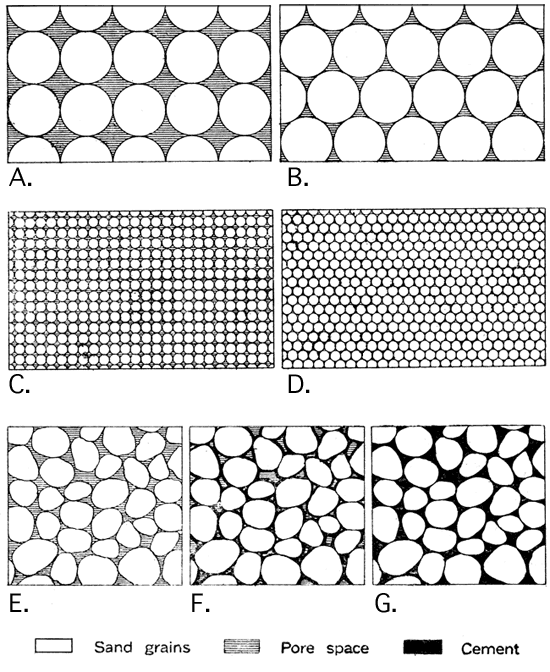
The fundamental requisite of an oil and gas reservoir is porosity. Shales have a relatively slight amount of pore space and the existing pores are very fine. Therefore, even though a shale is saturated with oil, a well drilled into it will hardly obtain a showing of oil, because the fineness of the openings in the rock hinders the escape of the oil. Limestones are, in the majority of cases, compact and rather fine grained, containing a relatively low amount of available pore space. The percentage of pore space in average sandstone is higher, but is by no means so large as that of most sands and conglomerates, because the cementing material which binds the grains of the sandstone together, to a greater or less degree, fills the pores. In average sandstone it varies from 5 to 15 percent, while in unconsolidated sands it may amount to 15 or 25 percent, and in conglomerates to as much as 30 percent. The porosity of the sands and the sandstones varies with a number of factors, such as the size of the grains, the uniformity of their shape, and the amount of clayey matter or cement between the grains (see plate IV). Spherical grains of uniform size, without any cement, would have a maximum pore space; grains of irregular shape and size, with abundant cement, have a minimum pore space. In case the spaces between the grains are completely filled with solid matter the rock may be absolutely compact and impervious (plate IV G). In sandstone of this type there can naturally be no commercially important accumulation of oil. Dry, nonporous sandstone may occur as local "dry spots" in the midst or porous sand reservoirs containing abundant oil and gas, or dry sandstone may be extensive enough to separate adjacent pools. Since lack of porosity is a matter of the rock texture, such irregularities cannot be predicted or defined except by drilling.
Plate IV--Pore space of rocks. A. Hypothetical rock with large spherical grains, maximum pore space. B. Hypothetical rock with large spherical grains, minimum pore space. C. Hypothetical rock with small spherical grains, maximum pore space. D. Hypothetical rock with small spherical grains, minimum pore space. E. Irregular grains without cement, showing maximum pore space. F. Irregular grains with interspaces partly filled with cement, showing reduced pore space. G. Irregular grains with interspaces completely filled with cement, no pore space. The total amount of pore space in A and C, or in B and D, is the same, but a fluid may be drained much more quickly and completely from the coarse-grained rock.
There is a not uncommon belief that oil is derived from underground lakes that are encountered by the drill. From the statements which have been made it is obvious that this is not a necessary assumption with regard to oil reservoirs, as the small pore spaces between the grains of the rock offer quite sufficient room for the accumulation of enormous quantities of oil and gas. Thus, in each 100 cubic feet of a sand containing 20 percent pore space, 20 cubic feet of oil might occur. An acre of such sand, 10 feet thick, would contain, if saturated, 15,553 barrels of oil, and greater thicknesses correspondingly greater amounts. It should be noted, however, that the total oil actually contained in a reservoir is never entirely capable of recovery. Indeed, under present methods of extraction, probably not more than 15 to 25 percent of the oil is, on the average, obtained from the reservoir.
An all-important requirement for the accumulation of oil and gas is an impervious cover or retaining roof which will hold the oil and gas in the porous reservoir. Such an enclosing cover may consist of almost any very fine or compact rock, such as shale, closely cemented sandstone or dense limestone. If the fine pores of the cover rock are filled with water, it is the more effective in retaining the contents of the reservoir below. In the absence of a suitable cover the oil and gas will escape from the reservoir, the lighter oil becoming volatilized and leaving behind a heavy residue. The abundant and heavy shales of the oil-bearing strata in Kansas have hindered the escape of the oil and gas, but at the outcrop of certain interbedded sands in Missouri (in the vicinity of Higginsville and elsewhere) heavy asphaltic deposits have been formed, due to the escape and evaporation of petroleum formerly present in the rocks. Impervious strata occur beneath as well as above most oil- and gas-containing beds.
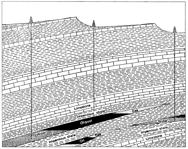
The lateral extent of the reservoir rocks is a matter of importance. If the sand is lenticular in shape (fig. 2), the capacity to hold oil and gas is gradually reduced in all directions until at the point where the sand disappears it is zero. If such a lenticular reservoir is enclosed between relatively impervious shale beds it may contain a large accumulation of oil and gas, even where inclined steeply, the shale at the end of the sand serving to retain the oil and gas. A very large number of the oil and gas reservoirs of the world are of this type. They are especially common in the midcontinent field.
Figure 2--Diagram showing oil and gas in porous lenses. The gas, oil and water accumulate in the order of their respective specific gravities, being hindered from escaping by the pinching-out of the reservoir between beds of essentially inpervious shale. Notice that there is no indication in the geologic structure of the existence of such oil deposits. The inclination of the beds is considerably exaggerated.
The accumulation of oil and gas has a fundamental relation to the geologic structure of the rocks containing them. There is rarely, if ever, a sufficient quantity of oil and gas initially distributed throughout a reservoir to permit commercial production, and consequently there must be a concentration of these materials in the reservoir. This further concentration is chiefly due to the geologic structure. In perfectly horizontal strata there is no force compelling accumulation of the oil and gas at any particular place in the reservoir rock.
Where the rocks are tilted there is a tendency, which is proportional to the amount of tilting and the degree of porosity of the rocks, for the oil to move along the strata. If the reservoir is very dry and sufficiently porous the oil will move downward under the force of gravity, but if the rocks are saturated with water, the oil and gas will be floated upward along the stratum.
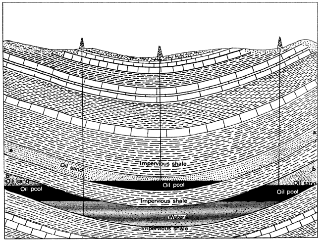
In the first case, which is exceptional, the oil may become concentrated at the bottom of a syncline or where water or some other obstacle is encountered (fig. 3). Oil accumulations of this type occur in the folded rocks of Pennsylvania and West Virginia and in at least one field (Spring valley, Uinta County) in Wyoming. In some instances a small syncline is filled with oil on account of its position on the limb of a larger anticlinal structure in which the oil and gas are concentrated. Downward movement of the oil tends rather to dispersion than concentration.
Figure 3--Diagram showing oil in a syncline. This diagrammatic, geologic cross section shows the occurrence of oil in a synclinal fold in which one porous stratum (a) is entirely dry, and in which another (b) is partly filled with water. It will be noted that in the dry stratum the oil sinks to the bottom of the fold, but in a partly filled bed it is floated on the water a certain distance up the sides of the fold. The vertical scale is greatly exaggerated.
In the second case the oil and gas are elevated as far as the water rises. If the water advances only a portion of the possible distance, the oil and gas may be partially concentrated and will not be under pressure (fig. 3, bed b). If, however, the pressure of the water is strong, they will be forced through the porous bed until they reach the earth's surface and escape, or until some obstacle is encountered which hinders further movement, when they may be compressed to occupy a minimum of volume.
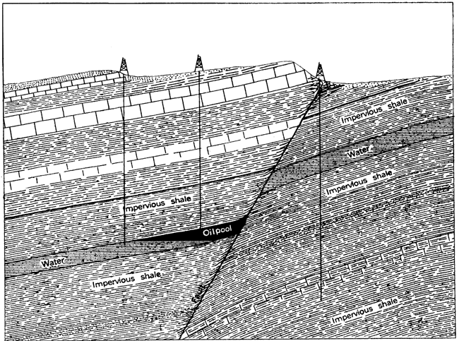
The obstacles to unimpeded upward migration of gas, oil, and water are various. If the reservoir rock is lenticular in shape the terminal upper portion of the lens will retain the fluid contents of the rock by reason of the inclosing impervious beds, the gas accumulating at the top, the oil next below, and the water occupying the lowermost portion of the reservoir (fig. 2). In some cases the reservoir stratum is broken across by a clay-sealed fault (fig. 4) or fine-grained igneous intrusion, which obstructs the movement of the gas, oil, and water through the rocks, and accumulation takes place in the same manner. Where an oil- and gas-containing bed crops out at the surface the oil and gas may escape, but in some instances the outcropping reservoir is effectively sealed by the very viscous or solid paraffin or asphaltic residues, which remain in the pores of the rock after the partial escape and evaporation of oil. Such a barrier may operate effectively to produce a concentration of the oil remaining in the reservoir.
Figure 4--Diagram showing oil sealed in by a fault. The oil in the porous bed has accumulated above the water, but is hindered from escaping by the impervious shale and clayey matter which cut across the oil reservoir. Oil formerly in the stratum to the right of the fault has escaped. Slight oil seepage may occur where the fault appears at the surface, but a well drilled here has missed the oil pool.
By far the most important obstacle to continued movement of oil, gas, and water along the reservoir, and hence a most significant cause of oil and gas accumulation is a marked lowering of the angle of inclination or a reverse tilting of the upwardly inclined reservoir stratum, forming a monoclinal or anticlinal fold (fig. 7) or dome.
Under these conditions the oil and gas are raised into the uppermost part of the structure, where they are prevented from further movement or escape by the impervious cap rock which overlies the reservoir bed. The gas, by reason of its lightness, will accumulate at the top of the structure immediately beneath the cap rock; the oil, having a specific gravity lower than the water, will be separated in a zone or layer between the gas and water, and the water will occupy the lowest parts of the reservoir.
In proportion to the sharpness of the anticline and the steepness of the inclination of the strata on either side, the oil and gas will be concentrated into narrow limits and the pressure will tend to increase. In some districts in California and parts of the Rocky Mountain fields, the oil-containing strata stand vertically, or are even overturned, and the amount of the arching or folding may be from 500 to 5,000 feet. In many cases, on the other hand, the anticline is so very broad and gentle, or the structural terrace (monocline) is so poorly defined, that the accumulation is not very effective. In Oklahoma and Kansas the strata have everywhere a very slight inclination, and the amount of folding or uplift is rarely more than 100 or 200 feet. For example, the vertical distance from the top of the anticline to the bottom of the adjoining syncline at Cushing, the most productive pool in the midcontinent field, and one of the most remarkable in the world, is but 160 feet. Such low deformations occur in most cases in a distance of one-half mile to a mile.
It should be observed that not all folds, even well-defined anticlines in oil regions, are productive of oil or gas. In some cases a structure is thought to be "dry" when the only difficulty is in the insufficient depth of drilling. Scores of instances might be cited from various localities in Kansas where, after many unsuccessful tests, oil has been discovered in quantity by merely drilling to greater depths. Some folds contain very good oil and gas deposits in certain portions of the structure, but are barren in others. This is due to variation in the porosity of the reservoir, the nonproductive part being so low in percentage of pore space as to contain little or no oil and gas, the productive part showing all the characteristics of the normal porous reservoirs. Such a lack of uniformity in the reservoir is rather the rule than the exception, and the existence of a single dry well does not by any means condemn a structure. In other instances, however, the structure is absolutely barren, the conditions having been unfavorable in various ways for the accumulation of oil and gas. Some of these unfavorable conditions are local absence of matter from which oil and gas are derived, or lack of proper initial conditions for preservation and distillation; lack of porous rocks suitable for reservoirs; lack of water to saturate the reservoir and force oil and gas to the top of the structure, in which case the oil, if present, will lie on the sides of the folds or in the bottom of the synclines; presence of intrusives or old land mass (granite of central Kansas) below the central portion of the fold.
In summary, the essential general facts with reference to commercially important pools of oil and gas may be stated as follows: (1) All42 so far discovered occur in sedimentary or water-laid rocks, such as sands, sandstones, conglomerates, limestone's, and shales; (2) the containing reservoir is porous rock, the amount of porosity and size of the pores directly controlling the possible accumulation and production of oil and gas; (3) the reservoir is capped or covered by practically impervious beds of shale, limestone, or sandstone, similar impervious beds in most cases also underlying the reservoir; (4) water is present in almost all cases in the oil and gas reservoir, and because of its greater specific gravity, tends to occupy the lowermost portion of the reservoir; (5) commercial oil and gas deposits are closely related to the structural character of the associated rock strata, occurring for the most part in the higher parts of folds, such as anticlines, domes, and monoclines.
[42. With the exception of the peculiar and relatively unimportant occurrence at Thralls , Tex.]
The evidences of the presence of petroleum or natural gas which are commonly noted by geologists, and used by them in the exploration of commercial pools and their development, are not such as can be properly evaluated by the average layman. These may for convenience be divided into (1) direct surface indications, and (2) indirect evidences. The former, which offer the more definite evidence of the existence of oil in the rocks, either in the particular locality of their occurrence or at a distance, include (a) oil seepages, or springs, (b) natural-gas springs, and (c) outcrops of sand impregnated with bitumen. The indirect are the structural features of the region that are so important in the accumulation of oil and gas.
(1) Oil seepages may exist where the outcrop of an oil sand reaches the surface, or where there is a crevice or fault through which the oil may rise to the surface. Seepages are most common in the lowlands or along small streams, sometimes appearing only as a faint scum43 on the water. In certain oil regions the occurrence of these scums on the surface of rivers lakes and ponds is rather common, but in the midcontinent field oil seepages are rather rare. The reason for this is that the beds in this region are so slightly tilted that for the greater part they remain unbroken, and there have been no means by which the oil could reach the surface except, perhaps, in the minutest quantity. Where the oil-bearing formations reach the surface in the midcontinent field the oil has doubtless already leaked away, owing to the fact that the productive strata are of considerable geologic age and there has been ample opportunity during long periods of erosion for the oil and gas to escape.
[43. Distinction must be made carefully between true oil scums and those of other substances on water. For instance, iron scum has been very commonly mistaken for petroleum, and some operators have invested thousands of dollars on such slight evidence. As a rule, where a film of petroleum is present it can be distinguished from that of iron by its odor. A small stick thrust into an iron scum will break it up into separate patches, while an oil scum is so thin and cohesive that it will retain its unbroken appearance and its iridescent color.]
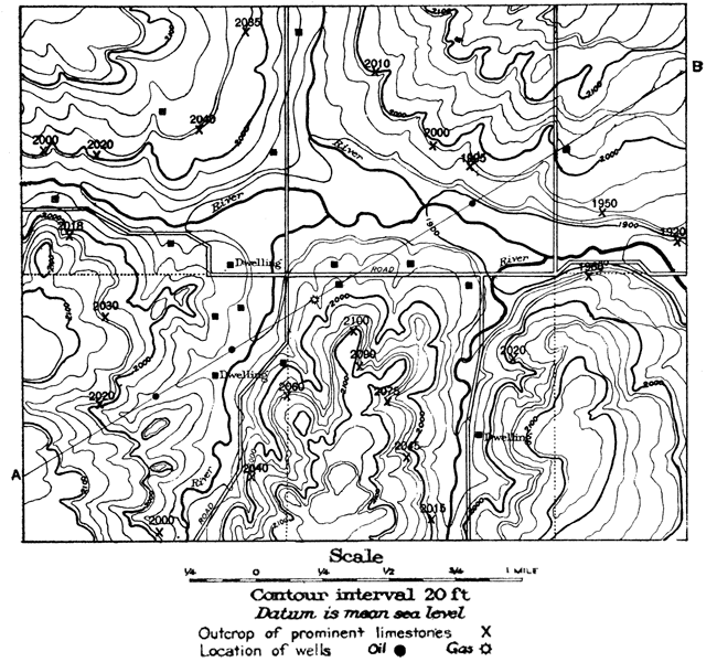
Figure 5--Topographic map of a small area, showing the position and elevation of outcrops of a prominent limestone bed. The lines, called contours, drawn around the hills are of constant elevation above mean sea level and are drawn at regular vertical intervals. Thus they show the actual elevation of the country, the shape of the hills and valleys, and the character of the slopes. The limestone formation traced by geologists appears at different elevations over the area, indicating definitely that the strata are not horizontal. A-B shows the line of vertical cross section, figure 7.
(2) In some oil and gas fields bubbles of gas rise in minute quantities through the water to the surface of streams, and at a few localities there are great gas springs. One such spring in the Baku district of Russia is reported to have been burning for thousands of years.44
[44. Clapp, Frederick G., The geology of petroleum: Am. Petroleum Industry, by Bacon and Hamor, v. 1, p. 36, 1916.]
(3) Outcrops of sand impregnated with bitumen, the so-called tar or asphalt sands, are not common, but exist in several parts of the world. One of the best-known occurrences in North America is that along the Athabasca and other rivers of northern Alberta, in Canada. Recently an asphalt-impregnated sandstone has been reported from the vicinity of Higginsville, in Missouri.
These surface indications have certain association with petroleum or natural gas, but commercially important pools of these materials in many instances lie at a distance from the point where the evidence appears at the surface. For example, where oil, gas or asphalt seepages occur at the outcrop of a gently inclined formation the important commercial deposits of oil may exist at a distance of several miles from the exposed outcrop. For this reason it is generally inadvisable to drill on or near seepages unless there is evidence that the main deposit of petroleum occurs directly below. In many cases it is possible for a geologist to locate the field from which the oil or gas has escaped.
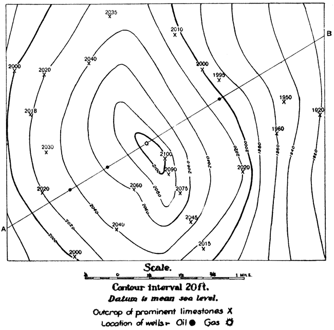
Figure 6--Structure contour map of area shown in figure 5, indicating the elevation and structure of prominent limestone bed. It should be imagined that the portion of the limestone bed which has been eroded away (see fig. 7) is restored and that all of the beds overlying the limestone are removed. The surface of the limestone would then appear as a low dome sloping away gently on all sides. If the area were flooded with water standing at 1,920 feet above sea level, the contour at this elevation would represent the shore line, and if the water were raised by 20-foot intervals the successive shore lines would be represented in turn by the higher contours. Thus if the water level were lifted to 2,100 feet only a small island in the center of the area would indicate the surface of the limestone bed.
From what has been said of the conditions governing the accumulation of oil and gas in the porous rock strata, it is evident that another class of surface indications may be used in exploration for these materials. This is the presence of folding in the rock strata, which, if pronounced, may be observed readily with the eye. If the folding is very slight it may be detected only with the aid of instruments by which the elevation of the outcrops of given strata may be noted and the direction and amount of their dips registered. By studying and mapping these indications of the rock structure carefully, a geologist is able to define fairly closely the general structure of the underground strata (fig. 6). Hence, if oil and gas are present in the strata at all, the position of their accumulation with reference to the observed geologic structure may be predicted and the most favorable area of probable production definitely and scientifically indicated. In the case of a well-defined anticline or dome (fig. 7), the central portion of the dome would be most likely to contain gas and oil. Wells drilled on the sides of the structure would probably strike oil or water.
Figure 7--Vertical cross section along line A-B across area shown in figure 5. The vertical scale is exaggerated about 4 1/2 times.
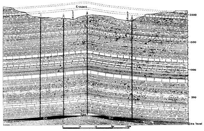
It is evident that the structure of the rocks has little or nothing to do, necessarily, with the character of the surface topography. Thus, the crest of a rock anticline may directly underlie a valley at the surface. (Fig. 7 and Plate V.)
In most oil regions, and especially in Kansas, there are numerous places where the solid rocks can be found in outcrops from point to point over the land. In most cases the ravines and creeks cut into the rocks in their natural bedding, and exposures may also be found along roadways or in railroad cuts. These are very important in gathering data for the geologic map. Indeed, without rock outcrops or other indication of the character and attitude of the strata, the geologist can do little. In practice, a single prominent bed, such as a limestone horizon or coal bed, is selected, and the measurements of geologic structure are either made directly on the chosen stratum or are referred to it. Since the sedimentary rocks of the earth are bedded more or less regularly one above another, the folding of the top layers indicates more or less accurately the folds of the lower layers. Consequently, the structure of the key bed at the surface indicates the structure of the oil and gas strata perhaps some thousands of feet below. This relation between the rocks at the surface and those deep below must be understood clearly to appreciate the work of the geologist. It should be borne in mind that vast quantities of rock have been removed from the surface of the earth by erosion. Ledges on one side of a valley match those on the opposite side, and the beds of one hill those of another. What erosion has taken away must, in imagination, be restored in order to form a picture of the original continuous extent of the key layer.
A very common mistake among prospectors for oil and gas, especially in the early development of petroleum in the United States, has been the belief that oil and gas pools run in uniform directions through the rocks. Accordingly, in certain fields thousands of wells have been drilled along definite lines and at given angles from existing pools that were supposed to represent the position of new deposits. However, pools are by no means always arranged in a definite system.
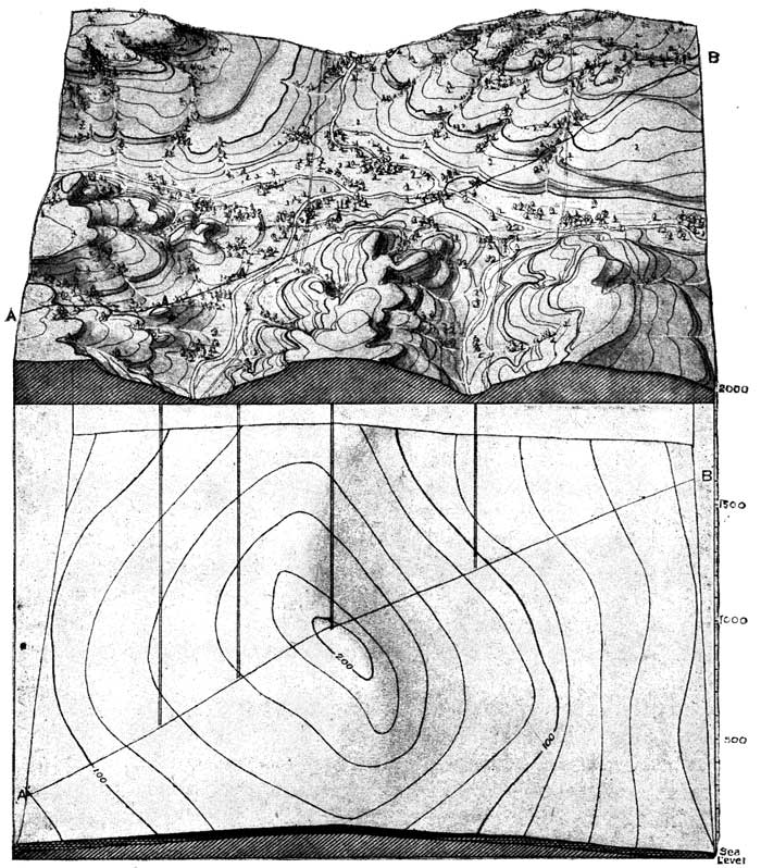
Plate V--Stereogram showing surface topography and underground structure of a typical oil and gas pool. The upper part shows the area mapped in figure 5 and below it a slightly folded gas- and oil-bearing sandstone layer the structure of which was indicated by observation of the outcrop of a prominent limestone bed (figs. 6 and 7). The line of the cross section A-B and wells (fig. 7) are indicated. Notice that the configuration of the land at the surface does not in this case have any relation to the underground structure.
The modern business of oil and gas production is in its present state a rather complicated and highly developed industry. There are many important factors to success, and the large companies are organized with minute attention to all the various details connected with the business.
In the development of a new oil or gas pool, for example, the geologic structure is first located and carefully mapped by competent geologists. Oil and gas leases on the lands overlying the structures are obtained, and when all the desirable land has been secured, drilling rigs are brought in for boring the wells. When a well is completed and oil or gas encountered, it is necessary to arrange for the storage or the disposition of the materials obtained from the well, involving the arrangement for pipeline transportation or tank storage. Large oil companies operating in any of the fields such as those of Kansas and Oklahoma have separate departments devoted to geologic exploration and mapping, leasing, drilling, pipeline and tank storage, buying, engineering, refining, and marketing.
In the case of an oil strike by any individual or company, the first step of the competing oil operator is to secure leases as near as possible to the producing well. If he has knowledge of the geological structure of the area he will follow the trend of the anticline or other favorable structure, and if he feels that the properties are within the limits of possible producing territory he may make locations and start drilling. In many cases, however, land is leased merely because it is in proximity to a producing well, and in the rush to newly proved areas many inexperienced operators, by lack of knowledge both of the nature of the business and of the underground conditions, are led to failure. It is often the case, however, that the inexperienced operator, or group of operators, is responsible for the location of new areas by wells of the "wildcat" type.
It should be noted that none of the large oil companies at present engaged in operations in any of the large oil fields drill wells in entirely unproved territory without any knowledge of the geologic structure. A "wildcat" well drilled without any knowledge of the underground conditions, and at a distance from producing areas, is a speculative hazard of the most extreme sort. Consequently, in any area that it is desired to test, reference to all geologic advice should be had at the very outset.
There are no set rules nor any strictly uniform practice in the matter of leasing. As this is necessarily more or less dependent upon local conditions, the oil men deal entirely with the individual landowners, and the oil leases are private bargains. The unit areas of the lease are the simple and uniform land divisions of the civil townships of 36 sections into which Kansas is divided. The sections are subdivided into tracts of multiples of 10 or 20 acres.
The usual form of oil and gas leases in Kansas grants to the oil producer, or lessee, the irrevocable and exclusive right to seek for oil and gas on the area covered by the lease, the length of the lease ranging from one to five years and "as long thereafter as oil and gas is produced in commercial quantities." In many instances the lease is taken for a period of five years, with option of extending the lease as production continues.
For the right thus given the landowner or lessor is paid one dollar to make the contract legally binding, and in addition such other considerations as may be desirable, varying with the particular case. The additional compensation to the landowner may be arranged for in a number of different ways. A stated consideration may be paid to the landowner for each acre as a bonus, depending on the probability of the production of the lease. In many cases the lessee arranges to pay so much rent per year for the lease, thereby holding it until it expires. The most important feature, however, in the compensation of the landowner is the royalty, which consists in the payment of a stated fraction of the gross production or profits of wells on the lease. This may, according to stated agreement, be paid either in cash or in oil.
In actual practice these various forms of remuneration for the right to drill supplement each other in various ways according to the agreement of the particular lease. For example, in a lease where a large bonus is paid, the royalty will probably be rather low, or if a small price is paid for the lease a large share of royalty may be exacted. In general, the price and the details of the lease contract depend on the nearness to producing territory and the probability of production in the area leased. In purely "wildcat" regions a bonus is seldom considered, but in a district that is located near good production a large bonus may be given. In addition to the customary royalty of one-eighth, bonuses as high as $100 to $200 per acre have been paid. In the Cushing field, Oklahoma, in one instance a royalty of 50 percent was given without bonus.
In the case of producing gas wells the amount and method of payment of the remuneration to the landowner are somewhat variable. On an average, about $100 to $150 per year is paid for each gas well, stipulations being made with regard to the use of the gas by the landowner and his payment for gas used.
In general, a landowner desires to have a test well drilled at as early a date as possible. Rental leases are therefore somewhat in disfavor, because the oil operator under these circumstances has the right to drill or not to drill at his pleasure. The common rental for commercial leases is $1 per acre per year. In some cases the leases have been so drawn that by payment of 10 to 25 cents per acre annually, after the expiration of the first period of time, the lessee may continue to lease for five or ten years, or indefinitely.
In many leases a time is set for the beginning and completion of a well, a clause being inserted to the effect that drilling shall begin within 90 days or other given time limit, and be completed to a specified depth within a given period, providing that oil and gas is not found in paying quantities above this depth. A clause may also be inserted requiring some sort of systematic continuation of drilling and development of the lease. In some cases a bond is required of the lessee as guaranty to the landowner of the fulfillment of the terms of the lease in payment of royalties, rentals, and damages.
In leasing of land for oil and gas, the lessor retains all surface right to the land except on the portion which is necessarily used by the operator for his equipment, including the full number of wells, power house, boiler house, tankage, waste pit, and pull rods. Upon an 80-acre tract not more than 5 or 6 acres are necessary for this. In a considerable part of the oil fields, the land is not considered sufficiently valuable from an agricultural standpoint to make it necessary to place any restrictions upon oil and gas operations. In certain portions of the field, however, farmers till the land and at the same time derive an income from the oil. Where the land adjoining producing oil wells contains a growing crop, it is agreed that the lessee is responsible for all damages to the crop, provided they reach sufficient amount to warrant complaint. Pipelines should be buried below plow depth, but the pull rods from the power house to the various wells are sometimes a source of more or less bother because they run just above the ground.
After production has been established the lease becomes one of the most valuable parts of the oil property. It may be sold or transferred at the option of the lessee, the price depending upon the number of producing wells and their average daily yield. Transfer of leases also takes place even before wells have been drilled, the price being dependent upon the distance from proven property. Lease speculation has become a rather lucrative business at the present time, especially in newly opened districts. The speculator closely watches the prospecting and development, and on news of an oil strike rushes to the locality and leases all available property with as little expense as possible. When the operators who really wish to drill come to the field later, they are forced to pay the speculator's price. Examples of this speculation may be seen in every newly opened oil district and have been common in the Kansas and Oklahoma fields. From the standpoint of bona fide development, the operations of the lease speculator are very undesirable both from the standpoint of the landowner and the real oil and gas operator.
The recent development in the production of natural-gas gasoline makes necessary provision for royalty to the lessor in this regard. The average lease is written without such provision.
After a favorable geologic structure has been located and leases have been secured, the operator must choose the location of the wells to be drilled. In the case of the first wells the selection of sites should be governed as nearly as possible by the geologic information that is available, the wells being located over the central portion of the anticline or dome. Such wells will form the most satisfactory test of the structure.
In cases where detailed geologic information is lacking, or where the entire area of a lease is likely to be productive, the wells are placed according to generally recognized rules and courtesies among the operators, or with reference to local conditions, such as the nature of the topography. Wells are commonly placed about 200 feet within the boundary line of the lease, but this distance varies, with the depth of the sand and other considerations, from 1 foot to 330 feet. Since it is common practice to lease oil and gas land in multiples of 10 acres, which equal 660 feet square, there is a tendency, especially in the midcontinent field, to put down wells at a distance of 660 feet from each other. In shallow sands they are located at greater distances apart, about 1,320 feet being an average interval. In large parts of certain fields, like those at El Dorado and Augusta, in Butler County, the wells are located with mathematical precision in rows and cross-rows. It is customary to place the wells on one lease directly opposite those on an adjoining one, in order to protect property lines and to prevent drainage of oil from the lease. This practice is termed "offsetting."
In practically all of the producing fields many wells have been drilled at distances much too close together. In one district in Oklahoma probably one-half million dollars has been spent on unnecessary wells within an area of 2 square miles, and in the Burkburnett district of Texas the timbers of adjacent derricks almost overlap in a number of cases. In the latter case the division of the land into town lots under different ownership has been the primary cause of much of this very wasteful drilling. No general rule applicable to all districts can be given, the proper distance depending largely on certain local conditions, which must be determined largely by close watch of wells drilled later among older wells. If the reservoir stratum is not very porous, gas or oil may drain into the well rather slowly and from a limited area. Wells recently drilled in the Iola gas field show a surprisingly large production, almost equaling the yield of wells first put down. This indicates the limited area drained by wells in this district. On the other hand, oil and gas may move readily a considerable distance through a very porous reservoir rock. The most efficient spacing of wells is really a geological problem, the terms of which include the depth to the sand, porosity of the reservoir, character of the oil and other factors in production.
When oil or gas has been discovered in one well there is still urgent need for accurate geologic information for use in the location of new wells, that there may be a minimum of dry holes and that additional leases secured may be the most profitable.
As a rule, leases are obtained and wells located as close to the producing wells as possible, on the strong probability that the oil and gas reservoir will also be encountered by drilling on adjacent properties. However, a reservoir usually extends a considerable distance farther along one line than in other directions, and a knowledge of the geologic structure and the probable outline of the porous reservoir is all-important in the scientific location of wells and in the development of adjacent areas. As soon as an important oil strike has been made the price of leases in the vicinity advances at an exceedingly rapid rate. It is consequently a difficult matter in certain instances to know whether it is better to pay a high price for leases in close proximity to producing wells or to invest in lower-priced leases at greater distances with correspondingly greater risk. The various factors entering into this consideration have been studied by Roswell Johnson.45 A statistical investigation of a number of pools in the Appalachian field indicates a rather rapid decline of production in this region for distances from 3 to 6 miles from the first well, and a more gradual decline at greater distances. So many are the variables, however, that no general statement of this nature applicable to pools in the midcontinent field can be made. It is, of course, almost certain that within the general area of a pool a number of the wells will prove dry or will contain only water. Consequently, the mere location of a lease in the general area of an oil or gas pool is by no means a guaranty of oil or gas production.
[45. Johnson, Roswell, Efficiency in the production of petroleum; in, Bacon and Hamor, The American Petroleum Industry, v. 1, p. 420, 1916; also, Petroleum and natural gas resources of Canada: Canada Dept. of Mines, Mines Branch, v. 1, p. 325, 326, 1914.]
In general the conditions most similar to those observed in the discovery well will be observed at the same level in the rock strata in either direction along the strike of the rocks. The reservoir is likely to persist in this direction and a uniformity of conditions will probably obtain.
Since gas, oil, and water in the rocks tend to arrange themselves in distinct layers in the order of their specific gravities, it is evident that gas, if present, may be expected in the uppermost parts of the reservoir, oil at points lower down on the dip, and water in the lower portions of the porous stratum. Consequently, if a well yields only gas, or gas with a little oil, an oil-producing well may be sought at a point down the dip of the reservoir, or if a well encounters water, or water and a little oil in the reservoir rock, an oil-producing well is most likely to be found higher up in the structure.
Since the productive pools in a reservoir usually have a greater extent in one direction than at right angles to it, careful observation of the production and rate of production of the wells may indicate to the producer the direction of this axis, and therefore suggest the most favorable line of development.
If pressure persists after a long flow, it is highly probable that an undrilled extension of the reservoir exists.
After a favorable geologic structure has been found and leases have been secured comes the operation of drilling. The methods of drilling are various and have been developed to suit the particular needs and conditions in different fields. In a region of soft, unconsolidated strata, such as parts of California or the Gulf Coast, the rocks are easily penetrated by a special type of drill, but in regions of hard strata, such as the midcontinent or Appalachian fields, this drill cannot be used successfully and other methods must be employed.
The system almost exclusively used in Kansas and Oklahoma is the so-called "standard" or cable drilling, which consists essentially of a heavy steel bit attached to a manila or wire cable, which is raised and dropped by means of a walking beam extending over the hole. It is especially adapted for drilling into hard formations or those sufficiently consolidated that the sides of the hole will not cave. Under these conditions drilling may be continued until it is advisable to case off a water- or gas-bearing stratum.
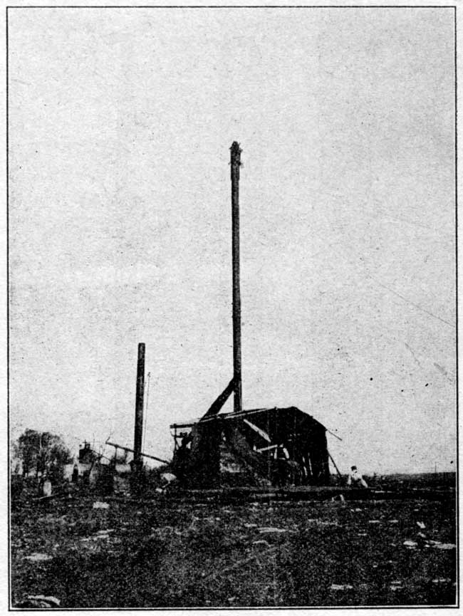
In comparatively shallow territory in the Kansas or Oklahoma fields a portable machine of the "Star" or "Parkersburg" type is commonly used (plate VIII). These have the advantage of being moved about easily even where roads are bad, with less loss of time than a heavy regulation outfit, but are not adapted for handling heavy strings of tools or casing. The time-saving and the cheapness with which such a machine can drill a well from 1,000 to 1,200 feet especially adapts it for developing shallow territory.
Plate VI--Standard drilling outfit, coupled for raising tools. (After Bowman, U.S. Geological Survey.)
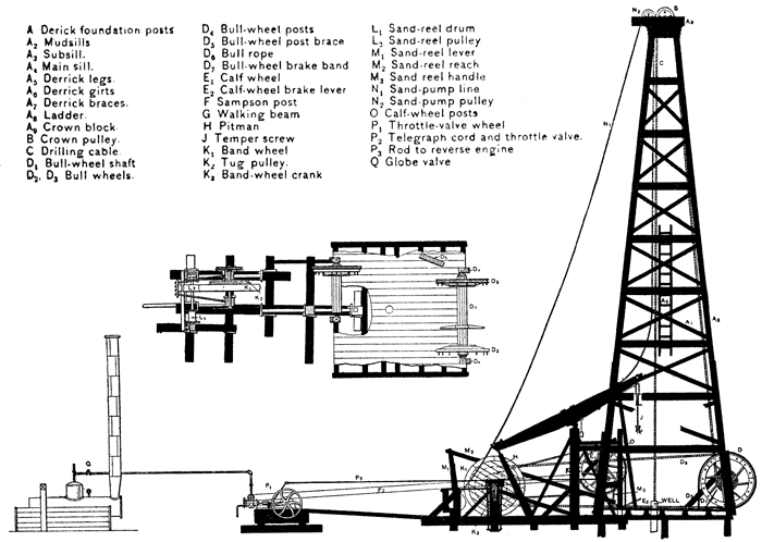
Plate VIII--Star drilling rig, south of Sedan.
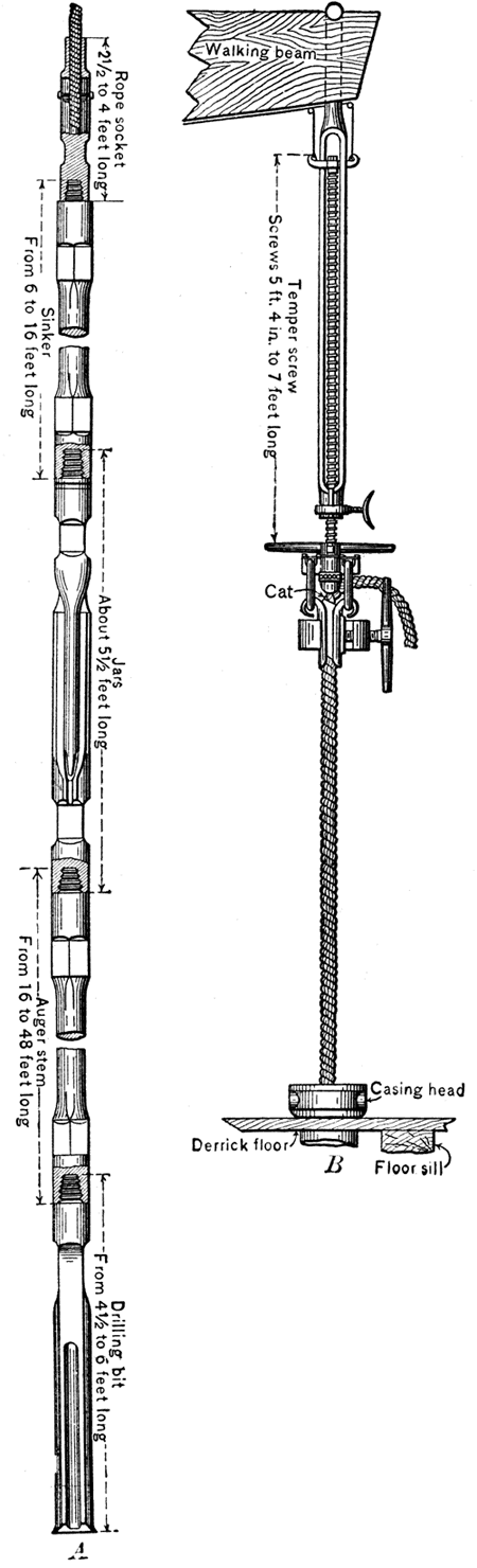
The site of the well having been selected, the first operation in drilling is the erection of the rig (plate VI). The main portion of this is the derrick, which consists of four strong uprights converging toward the top, held in position by ties and braces and resting on a strong foundation of concrete piers or wooden sills. For drilling the deeper wells the derrick is at least 70 feet high, on account of the length of the "string" of drilling tools, and from 20 feet wide at the base to about 4 feet at the top. The derrick is surmounted by the crown block, bearing the pulleys for the drilling cable and the sand-pump. The parts of the rig actually employed in the operation of drilling are, in addition to the drilling tools and cable, the temper screw (fig. 8) which grips the cable and adjusts its length to the depth of the hole; the walking beam, to one end of which the temper screw is attached; and the large wooden jack or band wheel, which gives power to the walking beam and other parts of the rig (plate VI). The temper screw is gradually turned as drilling goes on, increasing the depth of the tools from the surface. When the entire length of the screw, amounting to about 5 feet, has been let out, the tools are withdrawn and preparations are made for the next "run." The walking beam is a massive timber, measuring from 16 to 24 feet in length, which gives the vertical motion to the cable and string of tools. It is supported in the middle by the upright samson post and connected at the end opposite the temper screw by a pitman rod to a crank on the band wheel. The motion of the band wheel thus moves the walking beam alternately up and down. The drilling machinery is very simple, but the effectiveness of the drill is due to the peculiar form of the drilling tools and the skill used in handling them.
Figure 8--A, String of tools used with standard drilling outfit. B, Temper screw. (After Bowman, U.S. Geological Survey.)
After the tools have drilled the length of the temper screw into the rock it is necessary to draw the tools to the surface and bail out the sandy or muddy debris at the bottom of the well. For this operation an entirely different arrangement is necessary, the portions of the rig used being the bull wheel on which the drilling cable is wound, the crown pulley at the top of the derrick, and the band wheel which is connected to supply power to the bull wheel. The bull wheel consists of a reel on which the drilling cable is wound and an attached wheel on either side, one of which carries the driving belt from the band wheel, the other bearing a stout iron band brake by which the speed of the reel may be controlled. The cable, having been loosed from the clamps of the temper screw, runs directly to the crown pulley from the well, thence down to the bull wheel at the side of the derrick, and as the cable is wound on the reel the long string of tools is lifted out of the well up into the derrick. When the tools have been thus withdrawn the well is ready to be bailed.
The operation of bailing the well consists simply in lowering a sand pump or bailer by a separate line from the sand-reel pulley at the top of the derrick, allowing the bailer to fill and drawing it again to the surface. The bailer is a plain cylinder of light galvanized iron, with a bail at the top and a stem valve at the bottom (plate VII). As this projects beyond the bottom it automatically fills the bailer when lowered to the bottom of the waste trough at the surface. The average length of the bailer is about 15 feet, but some are as long as 20 feet. When the well has been bailed it is ready for further drilling.
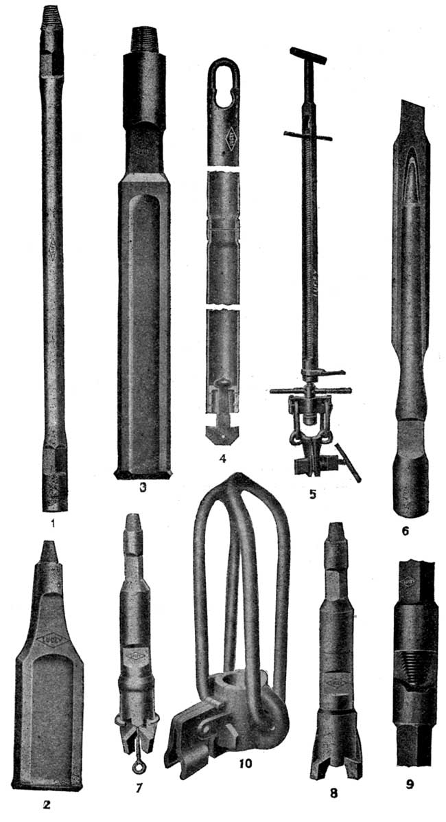
Plate VII--Drilling tools. 1, Auger stem; 2, spudding bit; 3, drilling bit; 4, bailer; 5, temper screw; 6, drilling jars; 7-8, underreamer, closed and open; 9, joint; 10, elevator, for lifting casing into derrick.
In some standard rigs, especially those used in California, an additional wheel, known as the calf wheel, is located opposite the bull wheel. It is used for handling casing, and saves much time because it obviates the necessity of disconnecting the tools from the drilling cable and the use of the bull wheel for this work.
Beyond the derrick and the other parts of the rig is the engine, which furnishes power to the band wheel by a belt. Steam power is almost universally used in the drilling of oil wells, the steam being supplied by a boiler located at a distance from the well in order to decrease the danger of fire. The engine is controlled from the derrick. Water for the boiler is obtained from a nearby water well or stream, but in some cases the matter of water supply is a serious difficulty and greatly hinders or delays the drilling of the well. Some of the wells in the El Dorado field have recently been drilled using electric power, the experiment being apparently quite successful.
The string of tools used in deep-well drilling consists of several parts, all of which have certain definite functions and are the outgrowth of years of experience. A full string comprises a rope socket, sinker bar, jars, auger stem, and bit (fig. 8 and plate VII). The socket is used to attach the end of the drilling cable firmly to the drilling tools, the methods of attachment varying rather widely in different cases. The sinker bar is a long, heavy bar used to give weight to the drill and to keep the hole straight. It was formerly thought to be essential to the string of tools, but is now used only in wet holes. The jars are in many respects the most interesting and important portion of the apparatus (plate VII). They consist essentially of a long double link with close-fitting but freely moving jaws, which may be compared to a couple of flattened and elongated links of chain. The links are about 30 inches long and are interposed between the heavy iron auger stem carrying the bit and the upper bar. The principal use of the jars is to give a sharp jar or jerk to the drill on the upstroke so that the bit is dislodged if it has become jammed in the rock. The drill responds to the powerful upward blow of the jars as they are jerked violently together by the stroke of the walking beam when it will not yield to the slow and relatively steady pull of the rope. The jars are not used to drive the drill into the rocks, such practice at the hands of an inexperienced driller invariably resulting in serious damage to the links within a short time. The auger stem (plate VII) gives additional weight to the blows that are struck, and also, by increasing the length of the drill, helps to maintain a straight hole. The drilling bits are of various patterns, according to the character of the rock that is being penetrated. A short, light bit is used in the preliminary drilling, known as "spudding" (plate VII). All the joints of the string of tools are fitted with taper-screw joints, so that they may be fastened together firmly with a few turns.
The operation of drilling an oil well as practiced in the midcontinent field may be described briefly. After the rig has been built the preliminary drilling, known as "spudding," is begun. For this a short, light bit is attached to a cable, which is run through the crown pulley at the top of the derrick and fastened to the bull-wheel shaft. The up-and-down motion to the spudding drill is given by a rope called the jerk line, which is fastened to the wrist pin of the band wheel and attached by a curved metal slide, called a spudding show, to the part of the cable that extends from the crown pulley to the bull-wheel shaft. Spudding is much harder on the derrick than ordinary drilling, because the entire strain comes at the top of the derrick, while in drilling with the walking beam the weight and jar of the tools is borne by the samson post.
After the hole has been deepened by spudding sufficiently to permit the use of the regular string of drilling tools, this distance amounting on the average to about 75 or 100 feet, the drilling cable is rigged to the walking beam by the temper screw and the regular work of drilling is begun. The pitman of the walking beam is fastened to the crank of the band wheel, and the beam begins to raise and drop the tools at the rate of about 25 strokes a minute. In the earlier drilling, when the length and therefore the spring of the cable is less, a shorter stroke is used than when the well has been drilled to greater depths.
The operation of drilling is frequently interrupted by the occurrence of an accident, such as the breaking of the cable, which necessitates the use of fishing tools of various sorts. If the fishing is successful, drilling is resumed, but if unsuccessful the well must be abandoned, often after weeks or months of labor.
A very important consideration in the drilling of a well is the casing, which protects the hole from caving and keeps out water. In many places where the surface material consists of a loose sandy clay or similar material, a conductor box or large iron "drivepipe," is sunk to bedrock. This facilitates the work of drilling the deeper portion of the well. The strata in the deeper portion of a well are, as a rule, made up of alternating layers of hard and soft beds, porous or slightly porous, and water-bearing or without water. Unless the water in the rocks is under considerable head it is welcomed by the driller, for it saves the trouble and expense of pouring water into the hole to keep the drillings from interfering with the work of the bit. If the water coming into the hole is too great, it is necessary to lower a string of casing from the surface to the first non-water-bearing rock below the water-bearing strata. The casing is set very hard into this lower layer and the water may be securely shut off by the use of a mud-laden fluid which is forced back under pressure into the porous rock and by the use of cement. Further drilling necessitates the use of a smaller bit that will pass within the diameter of the casing. If other heavy flows of water are encountered they must be cased off in a similar way. As many as eight or ten different strings of casing are necessary in some deep wells, which penetrate porous, water-bearing strata.
In comparatively shallow territory a well is sometimes drilled "wet," the water sands not being cased off and the tools running in a hole in which the water stands high. If the sides do not cave, casing may not be put in until the well is finished. Drilling under these conditions is, however, considerably slower and only rarely justifies the saving in labor and expense of casing.
Several varieties of casing are used. Sheet-iron riveted pipe is used in some foreign wells, but in American fields is almost unknown. Casing most commonly used in the midcontinent fields consists of sheet-iron pipe of various sizes and weights, depending on the depth of the well and the water pressure it is necessary to withstand. The ends of the sections are threaded, so that one section may be attached firmly to the preceding. The diameter of the casing pipe varies from 3 or 4 inches to more than 18 inches.
For the drilling of a well a contract is made between the operator and a drilling contractor on the basis of a certain price per foot, the amount of which depends on the locality and the depth of oil sand. The rate is fairly uniform in an active field, but in "wildcat" areas the rate is usually higher. Stipulation is commonly made in the contract for drilling to a specified depth, the contractor being held responsible for reaching this depth. The agreement usually calls for the commencement of drilling within a given time. The contractor purchases and constructs the derrick, furnishes tools, fuel, water, boiler, and engine, and hires the drillers and tool dressers. He is held responsible for accidents. Oil or gas which is found during the process of drilling may be used as fuel by the contractor. In general, he is required to handle all the necessary casing, and in case of a dry hole must pull out all the casing possible. The operator furnishes drivepipe, casing, and whatever rodding or tubing is necessary, provides for the hauling of the pipe and other accessories, except the derrick and driller's tools, and is responsible for plugging a dry well and filing affidavit thereto.
The cost of drilling varies notably in different fields, and under certain conditions may fluctuate widely even in the same field. The controlling factors are, in general, the depth of the well, hardness of the strata or other conditions increasing the difficulty of drilling, distance from supply center, and availability of working supplies such as fuel, water, etc. In the case of individual wells the cost may be from 50 to 100 percent higher on account of unusual underground conditions or accidents. In general, the drilling of an isolated well in the first development of a property costs more than later wells, because many items necessary for the first well may be used a second time in the drilling of adjacent wells.
One of the greatest needs at present in the scientific development of oil and gas fields of the state is good well logs. Every log should give the top and bottom of every sand that carries gas, oil, or water, in addition to giving the distance from the top of the sand to the level where the flow into the well is found. The character of other strata passed through, especially those of prominent horizons, such as limestone formations and coal beds, should be noted and described as carefully as possible. When drilling is begun in a new field, the logs, with samples of drill cuttings, should be studied carefully by a competent geologist in order to determine as accurately as possible the underground conditions and to advise with regard to further development. The State Geological Survey may act as a clearing house for such information and may give assistance in the correlation of formations, in determining the depth to given formations in various localities, the direction of the dip of the strata, and other features. Without care in recording the information obtained by drilling, and without the assistance of a geologist, the best results cannot possibly be obtained.
When the drilling of a well has been completed in a rather close-textured reservoir rock, or when the production of a well has begun to decline, it is common practice to "shoot" the well, a charge of nitroglycerine being generally used for the shooting. The amount of explosive used varies from a few quarts to 60, 80, 100, or even 250 quarts, and is placed in specially designed canisters. The canisters are lowered to the bottom of the well and discharged by dropping a nitroglycerine "jack squib" carrying a fulminate cap, which explodes on striking the torpedo at the bottom of the well. Formerly the percussion cap was placed with the charge at the bottom of the well and the torpedo was exploded by dropping a conical piece of iron--the so-called "go-devil"--upon the charge.
It is a matter of considerable importance, as shown in practice, to locate the nitroglycerine charge in the pay sand rather than to allow it to extend above into the barren formations. If the latter are shattered and fall into the pay sand the debris may interfere very greatly with the operation and production of the well. The use of too large a charge in the hope of thoroughly shattering the pay sand in a considerable surrounding area may so disturb and break the barren formations as to make the well valueless.
The problem of management of the oil well involves (1) the method of recovery of the oil, especially as practiced in the midcontinent field; (2) the more or less rapid but continuous decline from the initial production, the typical life history of all oil wells; and finally (3) the manner of handling the oil after it has been brought to the surface.
In certain parts of the Kansas oil fields the oil reaches the surface under its own pressure. Wells from which the oil thus flows are known as "gushers," and, especially when the pressure is very great, are much the most spectacular part of an oil field. The oil does not long continue to flow under its own head, even when the initial pressure is very great, and it then becomes necessary to pump the wells. The great majority of wells in the Kansas oil fields are of the pumping type, the method of pumping, however, varying greatly in different cases. Some wells are pumped by motive power--steam, gas, or gasoline engine--which is located at each well. This demands a separate power unit for each individual well. In other cases a central power plant supplies steam or compressed air to a number of pumps operating wells located around the plant. The central plant may be connected with the individual pumps by shaft or pull rods, which are so fastened to the operating drum at the plant as to compensate one another and make a minimum load on the engine. At the wells are pumping "jacks" of various design which convert the horizontal pull of the rods to a vertical movement of the sucker rods in the well.
It is impossible to determine in advance, with any degree of accuracy, the life of an individual oil well, but it is possible, by means of accurate records of the history of wells, and of the pool containing them, to obtain an approximate estimate as to the length of time during which the well or pool will be productive. A record of the production of an oil well always shows a maximum yield at its very beginning or immediately after a successful shooting of the well. This is known as "flush production." The production then drops off, suddenly at first, and then declines more gradually into "settled production." Minor irregularities in the plotted production curve may be due to the influence of neighboring wells or special conditions.
In most cases a record of the production of an oil field as a whole shows a gradual rise to a maximum, followed by a gradual decline. The increase in production at first is, of course, due to an increased number of wells as the field is developed. When the declining production of wells already drilled is not compensated by production of new wells, the total production of the field begins to decline.
The large initial production of many oil wells is evidently due to the strong pressure in the oil reservoir when the wells are drilled in. The duration of the period of greater production depends upon local conditions, such as the porosity and structure of the sand, the development of the pool, the position of the well, and the character of the oil. With the decline in pressure, production gradually decreases in many districts to a fairly constant amount. Decreased production is due to decline of gas pressure, decrease in quantity of oil draining into the area affected by the well, and perhaps by flooding either by saltwater or freshwater from adjacent strata. The drilling of nearby wells, defects in the setting of the casing, and failure to clean the well may be contributary causes to the decline.
Effective management of an oil well is aided by a carefully plotted record of the production of the well. This curve gives a fairly definite idea as to the yield that may be expected and indicates the probable future history of the pool.
After the oil has been brought to the surface, either by natural flow or by pumping, it is necessary to store it near the well or to arrange for transportation to a point where it can be used. Where the wells are some distance from a pipeline or from the railroad, it is usually necessary to have large storage tanks where the oil can be kept until its further transportation. The storage tanks are usually of steel and rest like huge covered tubs on the ground. The largest size used in the midcontinent field is the 55,000-barrel tank, which has a diameter of about 115 feet and a height of 30 feet. There are 30,000-barrel tanks, diameter 86 feet, height 30 feet; 20,000-barrel tanks, diameter 70 feet, height 30 feet; 10,000-barrel tanks, diameter 49 feet 7 inches, height 30 feet; 5,000-barrel tanks, diameter 40 feet, height 20 feet; and even smaller ones for temporary storage. These figures for the capacity and dimensions of oil storage tanks are, of course, subject to a variation depending on the local conditions. Recently, large storage tanks of concrete have been constructed underground. Greater storage capacity and smaller losses by fire and evaporation are advantages claimed for the reservoirs of this type. In the case of a well of the gusher type, it is frequently impossible to get sufficient tank space to store the oil, at least during the time of maximum flow. In this case earthen embankments are built and a large temporary reservoir constructed. Of course, in open-air storage of this sort there is a very large loss due to evaporation and to the dissipation of the lighter volatile constituents of the oil. It is therefore economical to have an air-tight sealed-roof tank; but under the conditions of the gusher some loss by evaporation is unavoidable. At the refineries are a large number of storage tanks of various sizes and types, both for crude oil and for various refined products. Before the oil is pumped to storage it is usually measured in small gauging tanks 25 to 100 barrels in capacity. Where the oil is kept moving, daily large storage tanks are unnecessary.
Crude oil is transported either by pipeline or by tank car. At the present time pipelines are being constructed almost as rapidly as refineries, and it is almost impossible, therefore, to give up-to-date information.
Pipelines that have been well established are shown on the general index map (part III). Wells in Texas and Louisiana belonging to the Gulf district are connected by pipelines through Oklahoma with the region about the Great Lakes and eastward to the Atlantic coast. The pipe used in these lines is about 8 inches in diameter, that in diverging branch, large main lines, 6, 4, and 3 inches in diameter. The crude oil is forced through the pipe from one pumping station to another and is conducted underground from the oil wells directly to the refinery. The most extensive system of pipe lines in the midcontinent field--probably the largest in any part of the country--is that of the Prairie Oil and Gas Company. This was the first company to begin operations in Kansas, when in 1893 a short line was built connecting the oil wells at Thayer, Kan., with a small refinery at Neodesha. At the present time there are a great number of independent refineries, which in most cases operate their own wells. Accordingly, there is an unusual development of short pipelines that connect the refineries with adjacent producing pools.
Oil may be shipped to the refinery in tank cars, but at present little is transported in this way, because in most cases the production of a pool is sufficient to warrant the laying of a pipeline. The chief use for tank cars is in the transportation of the refined products from the refineries. The cars vary in capacity from 3,600 to 12,500 gallons. Many of the refineries own their tank cars, but in some cases they are leased.
Where large quantities of oil are stored, either in the field or near refineries, there is always danger from fire. This may be due either to artificial causes or to lightning. Proper insulation of the tanks is usually sufficient to safeguard them from danger of ignition by lightning, and proper rules for employees will usually control the danger from artificial causes. It is, however, possible to extinguish fires that have started in tanks or oil reservoirs by means of chemicals and apparatus that can be installed easily. The general principle of such fire extinguishers is either to form a blanket of gas or foam over the burning liquid, which excludes the oxygen of the air, or to dilute the burning liquid with a non-inflammable agent, such as carbon tetrachloride, which extinguishes the flames. Some of the foam-producing mixtures have been particularly effective.
More or less successful refining of petroleum was in practice before the eighteenth century, but so great has been the advance in petroleum refining methods within the last few years that refineries seem to be only a recent development. The large number of refineries which have been completed within very recent years indicate the great importance of the refining industry. The large number now in construction shows its continued rapid development.
Most of the refineries in the midcontinent field are equipped with apparatus for the production of naphtha, illuminating oils and fuel oils. Some of them are prepared to distill the residuals and produce lubricating oils, paraffin, and other products. The general procedure at the refineries is about as follows: Crude oil is admitted into the storage tanks along the pipelines or received by rail from the tank cars. The oil is then run into the still and distilled by fire heat or by a combination of fire heat and superheated steam. The vapors from the still are carried into a condensing arrangement, about which is a cold-water jacket, and the liquid product run into a tank. Many of the large refineries distill petroleum by the "continuous system," in which the stills are connected and operated in a continuous manner. By firing successive stills to higher temperatures, fractions with successively higher boiling points are obtained simultaneously.
The chief methods of distillation are46 (a) the "dry" destructive or distillation "cracking" process, used when a large yield of gasoline and illuminating oil is desired; (b) fractional distillation; (c) vacuum process; (d) pressure distillation.
[46. For a complete account of petroleum refining methods, see Bacon and Hamor, American Petroleum Industry, v. 2, 1916.]
(a) "Dry" or "cracking" distillation process. In this process the heavy vapors from the crude oil condense in the top of the still and fall back on the superheated oil, and are thus "cracked" or partially decomposed. The first of the products to form is naphtha or benzine. In the destructive distillation of a paraffin-base petroleum the flow begins at about 80° Baumé gravity, the product being termed "light naphtha." The next distillation is from 69° to 58° Baumé, and is known as "heavy naphtha." The third fraction, which is generally called the "high-test burning oil," is collected from 58° to 43° Baumé. The fourth fraction is known as "low-test burning oil" and is collected until the residue in the still reaches 21° or 22° Baumé. Fractions 3 and 4 are usually redistilled in steam stills and yield "burning-oil distillate" and "burning-oil stock." The residue is called tar and contains the paraffin oil and paraffin wax. It is distilled to dryness, yielding "paraffin distillate" and "wax tailings," coke remaining behind. The proportion of the various products from this dry distillation is on the average as follows:
| Light and heavy naphtha (gasoline) | 12 to 15 percent |
| Burning-oil stock | 65 to 75 percent |
| Tar | 10 to 12 percent |
| Loss | 5 to 6 percent |
The temperatures at which the chief refinery products are derived in the "cracking" distillation of Kansas petroleum are as follows: When the temperature of the oil in the still is gradually raised from 200°F to 325°F, about 6 to 8 percent of crude naphtha (boiling point 200°F) is distilled. With a gradual increase from 325° to 475°F, 13 to 15 percent of the crude heavy is distilled; and to about 625°F a "natural lamp distillate," representing 16 to 18 percent, of the crude petroleum, is obtained. The destructive distillation known as "cracking" begins at a temperature of about 625°F. The cracking is carried on very slowly, until at 700°F, a distillate called the "gas and fuel-oil stock" is produced. This contains some gasoline, lamp oil, and heavier oils, and has an average boiling point of about 550°F. It comprises about 20 percent of the original crude petroleum. The residue left in the still at this temperature is a heavy black tar, about 42 percent of the crude oil.
(b) Fractional distillation. In the manufacture of lubricating oil from paraffin-base petroleum, "dry" steam is introduced into the oil. The hydrocarbons are then distilled at temperatures below normal boiling points, because the partial pressure on the hydrocarbons is less than that of the atmosphere.
(e) Vacuum process. In some refineries a vacuum process is used in combination with (b). It consists in the creation of a partial vacuum in the still, so that the hydrocarbons are distilled at temperatures considerably below their boiling points at atmospheric pressure.
(d) Pressure distillation. Several patented processes that involve pressure and high temperatures are now in use in the production of gasoline from gas and fuel oils. These "cracking" processes are too complex to be discussed here.47
[47. Bacon and Hamor, op. cit., p. 554-579.]
Benzine. The raw condensate distilled from crude petroleum from the lightest fraction to about 52° Baumé gravity.
Gasoline. This includes many steam-refined products from the benzine. Three grades of gasoline are produced in Kansas and Oklahoma-68° to 70° Baumé, 64° to 66° Baumé, and 61° to 63° Baumé. The last two grades are those ordinarily used in automobiles.
Naphtha. The portion of steam-refined benzine of gravity heavier than gasoline, showing a gravity of 50° to 58° Baumé.
Kerosene. Including the heavier fractions, showing a gravity of 52° to 36° Baumé. These condensates are chemically treated with sulfuric acid and caustic soda. Several grades of kerosene and naphtha are manufactured by various refineries.
Fuel oil. This is an indefinite term, and there are no specifications for midcontinent fuel oils. It must not contain gasoline and many customers require that it be of such consistency that it can be pumped through pipes and burners.
Road oil. An indefinite name, covering grades of oil used chiefly as a dust preventive, ranging from 34° Baumé to an asphaltic material which is solid at 60° F. Several grades of road oil are produced from Kansas petroleum.
Lubricating oil. A great many grades of lubricating oil are produced at some of the refineries. Various companies have their own trade names for the different grades of these lubricating oils. In 1916 there were six refining companies in Kansas listed as producing lubricating oils.
The refining of crude oil has undergone great changes during the past two years. Undoubtedly one of the chief factors has been the very rapidly increasing demand for gasoline. In 1915 average motor gasoline ranged from 60° to 64° Baumé. That generally used at this time has a distinctly lower gravity. Very little 60° to 61° gasoline is sold, the average being from 54° to 56°. This heavier fraction, formerly called naphtha, is now included in gasoline. It is realized, however, that degrees Baumé gravity do not necessarily indicate the quality of the gasoline or oil produced. It has been demonstrated that a 57° product may be just as good or better than a 60° product from another oil which has been treated in another manner.48
[48. An illustration of this is given by Mr. H. G. James, president of the Western Petroleum Refiners Association (James, H. G., Refining Industry of the United States, Derrick Publishing Company, Oil City, Pa., 1916) : "Taking a 40° gravity Cushing crude, a first-class 58° gravity gasoline is made by starting the initial at 125°F. and cutting the end point at 410°F. Now let us suppose the initial of this same end point is 140°F., and the end point 460°F., you will secure a larger quantity but a far inferior product. In other words, a 58° gravity gasoline, as first described above, is a much superior article to a 60° or 61° with an initial of 130°F. and an end point of 435°F."]
Figure 9--Average midcontinent crude petroleum contains 5 to 10 percent naphtha, 34 to 40 percent kerosene, and 50 to 60 percent residues.
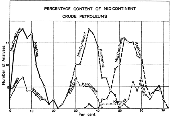
[49. Johnson, R. H., and Huntley, L. G., Oil and gas production, chapter XVII, 1916.]
Mention of natural-gas gasoline is not out of place here. Under a compression of 350 pounds, casing-head gas yields from 1 to 4 gallons of "wild" gasoline per 1,000 cubic feet of gas. In practice, commercial plants produce from 1 1/2 to 3 gallons. The gasoline produced is in many cases higher than 88° Baumé, but it is allowed to "weather" to this gravity before being shipped to a refinery for blending with low-grade naphtha.
A new process, in which gasoline is absorbed in oil, makes it possible to treat great quantities of gas rapidly. The oil, with its absorbed gasoline, circulates through a continuous still, in which gasoline is driven off and condenses separately, the oil going back to the absorbing apparatus.
The gas gasoline is sold to refineries to be blended with low-grade naphthas in the production of commercial-grade gasoline, or is used in various chemical industries. Because of its very light, volatile character, gas gasoline is very valuable in the production of highest-grade motor spirits for airplanes and other powerful gasoline engines. Kansas led the United States in 1919 in percentage of increase in the production of natural gas gasoline.
Kansas Geological Survey, Oil and Gas Resources of Kansas
Placed on web Aug. 18, 2011; originally published in 1920.
Comments to webadmin@kgs.ku.edu
The URL for this page is http://www.kgs.ku.edu/Publications/Bulletins/6_1/02_origin.html