![]()
Prev Page—Structure || Next Page—Cherokee and Distribution
McLouth Sand
Lithology
The variable assemblage of lithologic types that constitutes the McLouth sand does not permit precise classification and description. Although this subdivision of the Cherokee is termed in the aggregate McLouth sand, only about one-half of the body of sediments actually is sand. A characteristic feature of the McLouth sand is intricate interlamination and interbedding of different lithologic types, some of which, in addition, are vertically and laterally intergradational. The outline classification (table 2) gives a breakdown into generalized lithologic types and varieties based largely on composition and grain size.
Table 2—Classification of generalized lithologic types of the McLouth sand, based on composition and grain size. (The quantitative importance of the lithologic varieties is indicated by asterisks: *** abundant; **, common; * uncommon, but not rare; no asterisk indicates rare.)
|
Examination of large fragments shot from wells has indicated that the sandstone beds of the McLouth are not solid bodies of sand but contain thin layers of siltstone, clay, or shale. The presence of these layers is also indicated by study of well cuttings from sandstone zones, the larger fragments commonly showing contacts between sandstone and siltstone, clay, or shale. These thin layers of impermeable material probably have an important effect on the passage of fluids through the sandstone beds.
Another feature of the McLouth sediments that must have an important effect on the movements of gas and water is the tendency toward lateral variation in lithology and the inter gradation between different lithologic types. The McLouth reservoir furnishes several examples of sandy zones that grade laterally from productive sandstone to nonproductive beds of sandy siltstone or shale containing only thin layers of argillaceous sandstone. Furthermore, the degree of cementation of the sandstone beds shows much lateral variation. Thus, lateral trends from permeable to nonpermeable rocks are common.
Forest City Well
Table 3 is a log of the basal 210-foot thickness of the Cherokee in the diamond drill hole on the W. F. Davis farm near Forest City, Missouri. This partial log, a result of the examination of cores, was taken from the report on the geology of northwestern Missouri by McQueen and Greene (1938). The sandstone and associated beds in the lower 119-foot section of this log have much in common with the McLouth sand and are believed to be its correlative. The two asterisks in table 3 mark the point believed to be the equivalent of the top of the McLouth sand. The dark, argillaceous, fossiliferous limestone reference bed of the McLouth field also is represented in this well. The greater thickness of the McLouth sand and of the interval between the top of the McLouth and the base of the limestone reference bed in this well, as compared with thicknesses in wells of the McLouth field, probably is due to the fact that the Forest City well is in a structurally deeper part of the Forest City basin where the entire Cherokee section is thicker and where differential subsidence was greater.
Table 3—Log of the lower part of the Cherokee shale in the diamond drill hole on W. F. Davis farm, sec. 4, T. 59 N., R. 38 W., Forest City, Holt county, Missouri. (From report by McQueen and Greene, 1938, p. 174.)
| Description of lithologic units | Thickness | Depth | ||
|---|---|---|---|---|
| feet | inches | feet | inches | |
| 1,403 | ||||
| *Limestone, dark, argillaceous (calcareous shale to 1,412). Contains some shells | 22 | 3 | 1,425 | 3 |
| Sandstone; contains much woody material and large brown spores | 9 | 9 | 1,435 | |
| Shale, black | 5 | 1,440 | ||
| Shale, gray, badly slacked. Some pseudo-oolites of siderite and plant fossils | 26 | 1,466 | ||
| Shale, black, thin-bedded, some shells; much carbonized wood. From 1,465 1/2 feet to 1,474 1/2 feet very shaly coal. Pyritiferous badly slacked. Some sandy shale, black toward base | 22 | 8 | 1,488 | 8 |
| **Sandstone, tan, medium coarse-grained, plant fragments carbonized | 1 | 9 | 1,490 | 5 |
| Interbedded sandstone and darker gray shale. Sandstone is white, fine-grained, with glauconite, mica, and clay particles. Shale is mica-bearing and fissile | 3 | 1 | 1,493 | 6 |
| Shale, gray, badly slacked, with carbonized plant remains | 1 | 10 | 1,495 | 4 |
| Sandstone with interbedded shale and clay- filled cavities. Many plant remains, carbonized wood. Some siderite cement | 11 | 2 | 1,506 | 6 |
| Shale, dark gray to black with fossil plants, some linguloid shells, conodonts, and spores | 11 | 8 | 1,518 | 2 |
| Sandstone, fine-grained, with mica and plant remains; brown spores. Becomes shaly and more fine-grained with depth | 6 | 10 | 1,525 | |
| Grades into shale, gray, micaceous with some sand, spores, woody fragments | 5 | 1,530 | ||
| Clay, soft, gray, with plant fossils, leaf imprints | 4 | 6 | 1,534 | 6 |
| Interbedded shale (micaceous), and sandstone, thin layers, with carbonized wood and plant remains, spores. Sandstone from 1,441 feet 10 inches to 1,442 feet 6 inches | 21 | 1,555 | 6 | |
| Sand, fine-grained, irregularly bedded with cross-bedded appearance. Many plant remains | 1 | 8 | 1,557 | 2 |
| Shale, black, carbonaceous; some linguloid shells | 2 | 10 | 1,560 | |
| Clay shale, with leaf imprints. Irregular beds | 5 | 1,565 | ||
| Shale, black and dark gray, carbonaceous. Many plant remains. Sandy, conglomeratic at 1,580 feet to 1,582 feet. Sandy at 1,586 1/2 feet to 1,587 1/2 feet. Large brown spores. Some thin sand beds in lower 10 feet | 48 | 1,613 | ||
| Top of Mississippian rocks | ||||
| *Probably the correlative of the dark, argillaceous, fossiliferous marine limestone occurring approximately 20 feet above the top of the McLouth sand in the McLouth field. ** Probably approximately correlative with the top of the McLouth sand in the McLouth field. |
||||
A notable feature of the McLouth sand in the Forest City well, similarly as in the McLouth field, is the abundance of carbonized wood and other plant remains, spores, and leaf imprints, and the generally carbonaceous character of the sediments. The presence in the Forest City well of linguloid shells and conodonts in black shale is significant of similar environmental conditions. Other features of the basal Cherokee of the Forest City well that indicate the similarity of the Kansas and Missouri sequences include the assemblage of lithologic types of the McLouth, as described in the present report, the presence of siderite cement, the interbedding and intergradation of sandstone and shale, and the conglomeratic character of certain beds.
Character of Sandstone Beds
The constituents of the sandstone beds of the McLouth reservoir have been determined by petrographic study of thin sections of shot fragments and by binocular microscopic examination of cuttings. These constituents may be grouped into three general categories: (1) detrital grains mostly of sand size, (2) minerals precipitated in place, primary, almost contemporaneous, or formed during later diagenesis, and (3) material of the clay "paste," which in the argillaceous sandstones partially or completely fills the interstices between the sand grains or forms a matrix in which the grains are set.
The detrital grains consist predominantly of quartz sand. Accessory detrital constituents comprise grains of feldspar, biotite, muscovite, and chert; heavy minerals, including grains of zircon, leucoxene, ilmenite, magnetite, and tourmaline; rock fragments through sand and pebble size composed of locally derived Cherokee siltstone and clay; and carbonized fragments and comminuted particles of land plants. Part of this detrital material, including the quartz, feldspar, biotite, muscovite, and heavy minerals, probably was derived from regions beyond the boundaries of the Forest City basin and was carried some distance to the area of McLouth deposition; whereas other constituents of the sandstone beds, including fragments of siltstone and clay and remains of land plants, probably were of local derivation and carried but a relatively short distance. Grains of detrital chert in the sands are common only at the base of the McLouth sand and probably were derived from residual material by weathering of cherty Mississippian limestones exposed in the Forest City basin region.
Quartz constitutes more than 95 percent of the detrital grains in sandstone beds of the McLouth sand. The grains vary considerably in average size and degree of sorting. Most of the sands show poor or only fair sorting and consist predominantly of fine sand (1/8 - 1/4 mm) with admixtures of very fine grains (1/16 - 1/8 mm), medium grains (1/4 - 1/2 mm), and locally contain quartz granules (2 - 4 mm) having irregular outlines and highly frosted surfaces. In samples from a few wells quartz sands having grains of two dimensions (grain-size distributions) were noted, a typical example being a very fine to fine sand containing an abundance of coarse sand grains ranging from 1/2 to 1 mm in mean diameter.
In general, very fine and fine sand grains are angular to subangular. Thin section studies indicate that in certain beds the angularity is due in part to secondary quartz growths. The coarse and very coarse sand grains, as a rule, have subangular or subrounded outlines, although a few are well-rounded; in the argillaceous sandstones this tendency toward roundness for the most part has been retained. In the nonargillaceous beds, however, the pore spaces have been partly filled with secondary quartz growths on the detrital grains, and angularity thus has been imposed, but the original subrounded or rounded outlines commonly may be detected by thin-section study. Thin sections reveal some medium and coarse grains whose outlines are in part angular and in part subround or round. They probably represent broken fragments of larger rounded grains.
There are several miscellaneous features of the quartz sand grains that are worth noting. Replacement of the margins by authigenic sericite, resulting in a serrated appearance, was found in several quartz grains. Most of the grains have few inclusions, and uniform extinction under crossed nicols probably represents normal igneous quartz. A large number, however, have marked undulose extinction and strain shadows and may represent metamorphic quartz; this conclusion is strengthened by the presence of a few subangular quartzite fragments of coarse sand size. In most of the sandstone beds the coarse sand grains show in thin section at least a slight tendency toward preferred dimensional orientation, and in a sample from one of the very coarse basal sandstone beds preferred orientation was prominent.
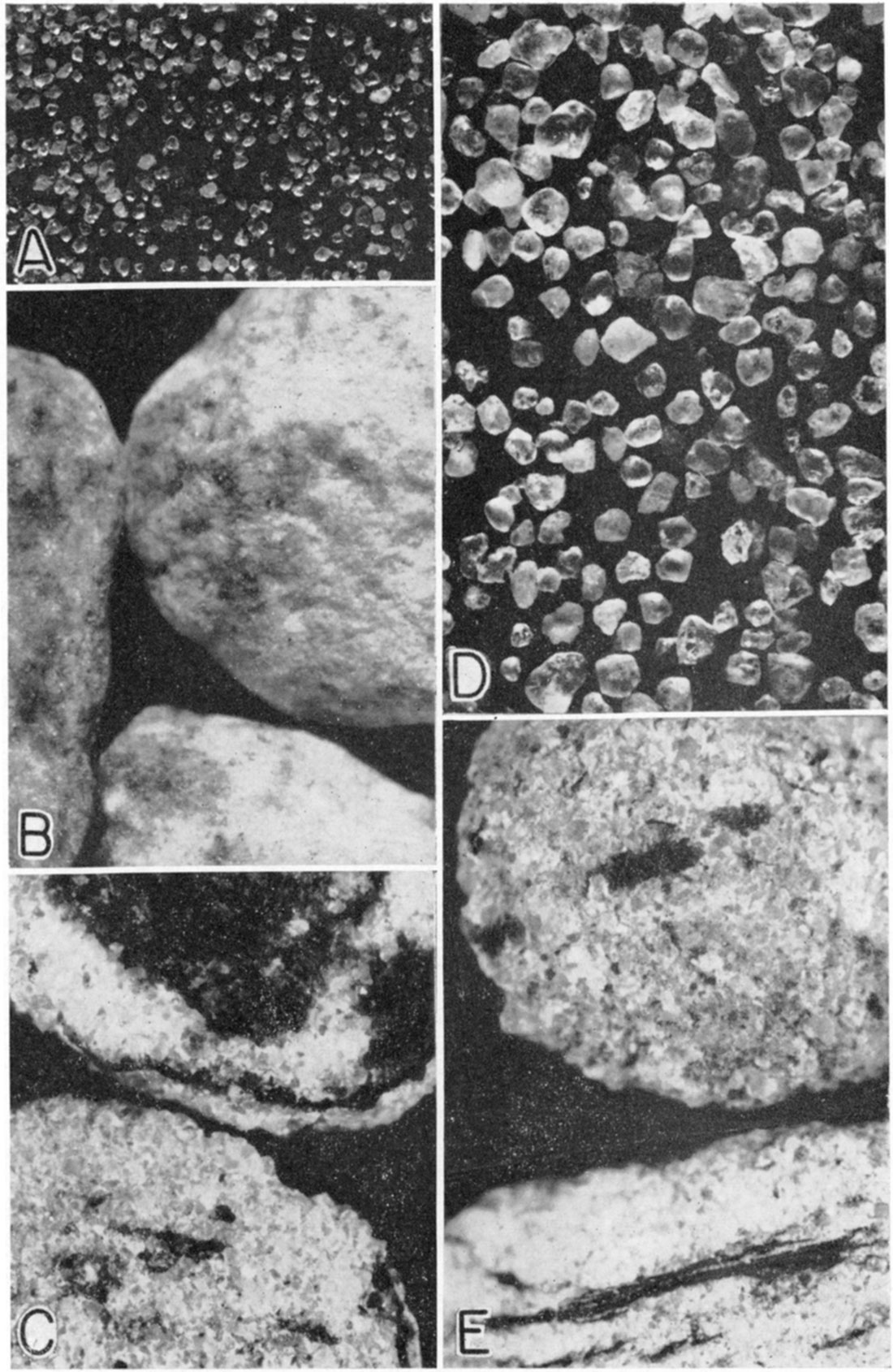
Plate 5—Photograph of core (X 10) from dolomite yielding oil in undifferentiated Burlington and Keokuk limestones of Mississippian age. The core was taken at 1,595 feet in the J. B. Apperson et al. (T. W. Sowell) No. 1 Bower well, in the SE NE sec. 5, T. 10 5., R. 20 E.
The rock was originally a conglomerate of calcareous fossil fragments including crinoid stems, imbedded in a matrix of sucrose dolomite. The solution of the more soluble limestone fragments during a period of weathering left a porous mass of irregularty distributed cavities in the dolomite which constitutes the reservoir in which oil has accumulated.
Feldspar, comprising microcline and orthoclase, constitutes on the average about one-half of 1 per cent of the detrital grains seen in thin sections. The feldspar grains range from very fine to medium sand size. The larger detrital mica flakes, including both muscovite and biotite, are distinct from the minute mica flakes and shreds of the clay "paste" and average approximately 1 percent of the detrital material. They are partly concentrated in irregular laminae probably parallel to the stratification planes. Most of the biotite flakes are chloritized. The flakes of mica tend to be ragged in outline, and the larger ones commonly are bent around quartz grains.
Zircon and leucoxene are the most abundant heavy minerals in the sandstone beds of the McLouth sand. Other detrital species noted include magnetite, tourmaline, and ilmenite which usually is coated with a white crust of leucoxene. Taken together, detrital heavy minerals average only a fraction of 1 percent of the sands. Except for refractured grains, they commonly are well rounded and range in grain size from coarse silt through very fine and fine sand.
Rock fragments of local derivation are present in minor quantity in most argillaceous sandstone beds, and in several beds were found to constitute a major detrital constituent. They are composed largely of siltstone and clay, rock types indigenous to the McLouth sand, and range in size from 0.4 mm (mean diameter) through the coarse sand, granule, and pebble size grades. Locally, the larger fragments form breccia and conglomerate phases, the character and origin of which are described in a later section of the present report. That these siltstone and clay fragments were derived locally during McLouth time is indicated by the following facts: (1) they are the same rock types that occur elsewhere as ,beds in the McLouth, (2) they are for the most part angular to subangular, and (3) they consist of rather easily dis integrable material that could withstand transportation only over a very short distance. These fragments probably were derived from locally disrupted beds of partially lithified siltstone and cohesive clay.
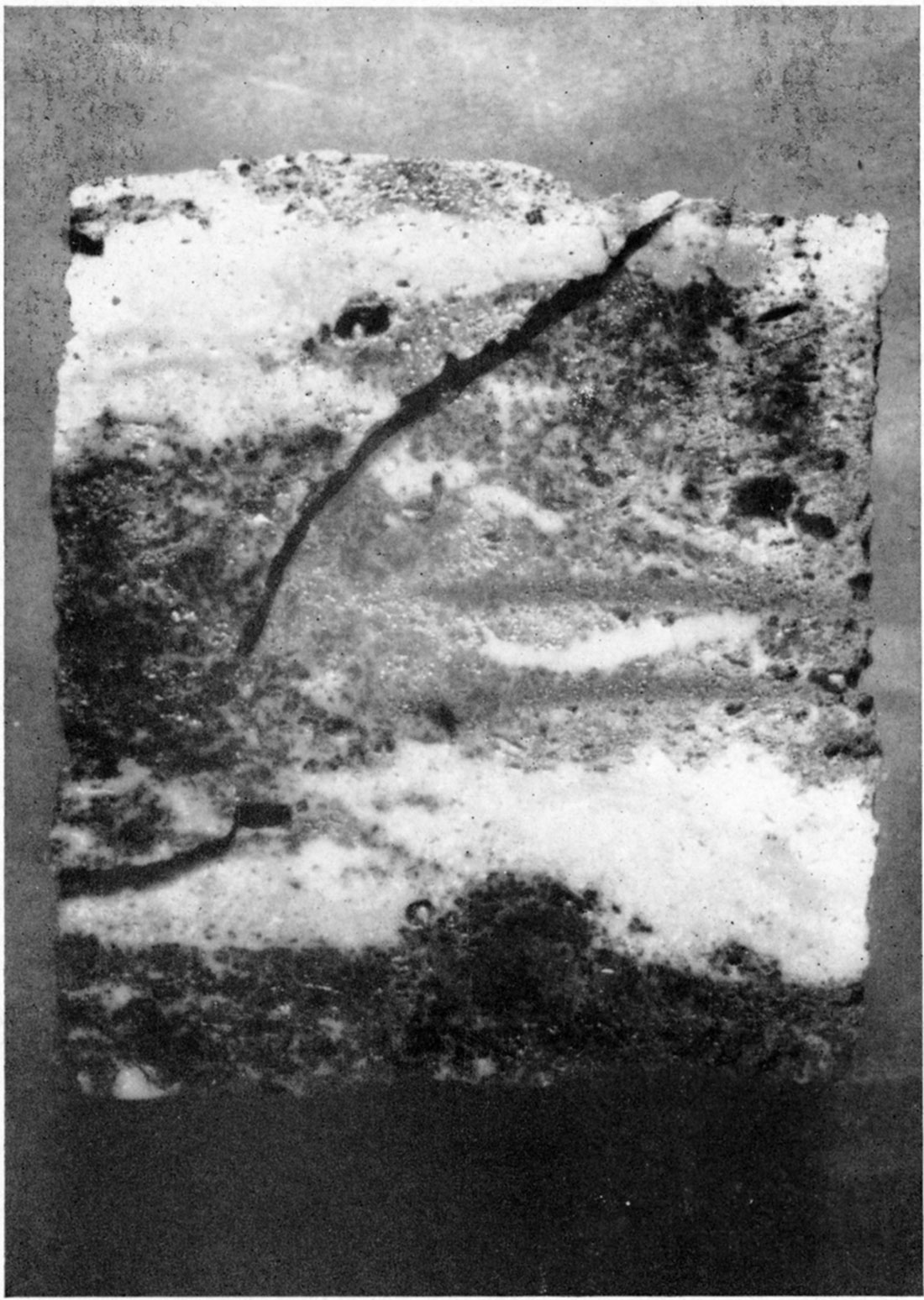
Plate 6—Photograph of core, sawed in half, (X 1/4) from dolomite yielding oil in undifferentiated Burlington and Keokuk limestones of Mississippian age. The core was taken at 1,595 feet in J. B. Apperson et al. (T. W. Sowell) No. 1 Bower well, in the SE NE sec. 5, T. 10 S., R. 20 E.
The illustration shows the distribution of cavities in the porous dolomite due to the solution of crinoid stems and fragments of other fossils, and also the irregular saturation by oil (dark areas) of the porous rock. This core probably does not represent the zone most productive of oil.
Minerals of the second category, those precipitated in place, comprise quartz, siderite, calcite, dolomite, and pyrite, of which quartz and siderite are by far the most abundant. Quartz occurs in the form of secondary growths and as interstitial cement. Siderite occurs both as interstitial cement locally in sandstone beds and as a prominent constituent of certain of the argillaceous sandstone beds, in which it takes the form of irregular thin lenses and laminae and is associated with carbonaceous material, Thinsection studies have shown that the siderite lenses and laminae commonly contain siderite spherulites in the form of complete spheroids and sectors of spheres; these also occur outside of the lenses and laminae. The spherulites, averaging 1/8 - 1/4 mm in diameter, consist of a radiate arrangement of crystal fibers about a common center and display a black extinction cross between crossed nicols. Some of the spherulites are separated, whereas others occur in clusters, the individual growths of which coalesce and are mutually interferent. Many of the spherulites completely enclose fine quartz grains or partially envelop large grains of sand size around part of which they have grown. Thus, it is evident that they were formed after deposition of the detrital quartz. Inasmuch as the siderite lenses and laminae constitute a large part of several of the argillaceous sandstone beds and are not merely interstitial, they are believed to have been primary or almost primary and laid down during intervals of quiet water between the times of sandstone deposition.
Calcite and dolomite occur in very minor quantities, constituting less than one-tenth of 1 percent in most sandstone beds, but in a few beds calcite serves as a minor cementing substance. constituting less than 1 percent of the rock mass. Where it is not in the form of cement, calcite occurs as tiny lenses and scattered irregular patches. Dolomite is limited in its mode of occurrence to minute idiomorphic rhombs scattered at random through the rock mass. These carbonate minerals are authigenic and probably originated during penecontemporaneous or later diagenesis. Authigenic pyrite also is present in minor quantity, generally less than one-tenth of 1 percent, and is in the form of tiny cubes, pyritohedrons, and irregular patches. It is limited for the most part to sandstones containing carbonaceous material.
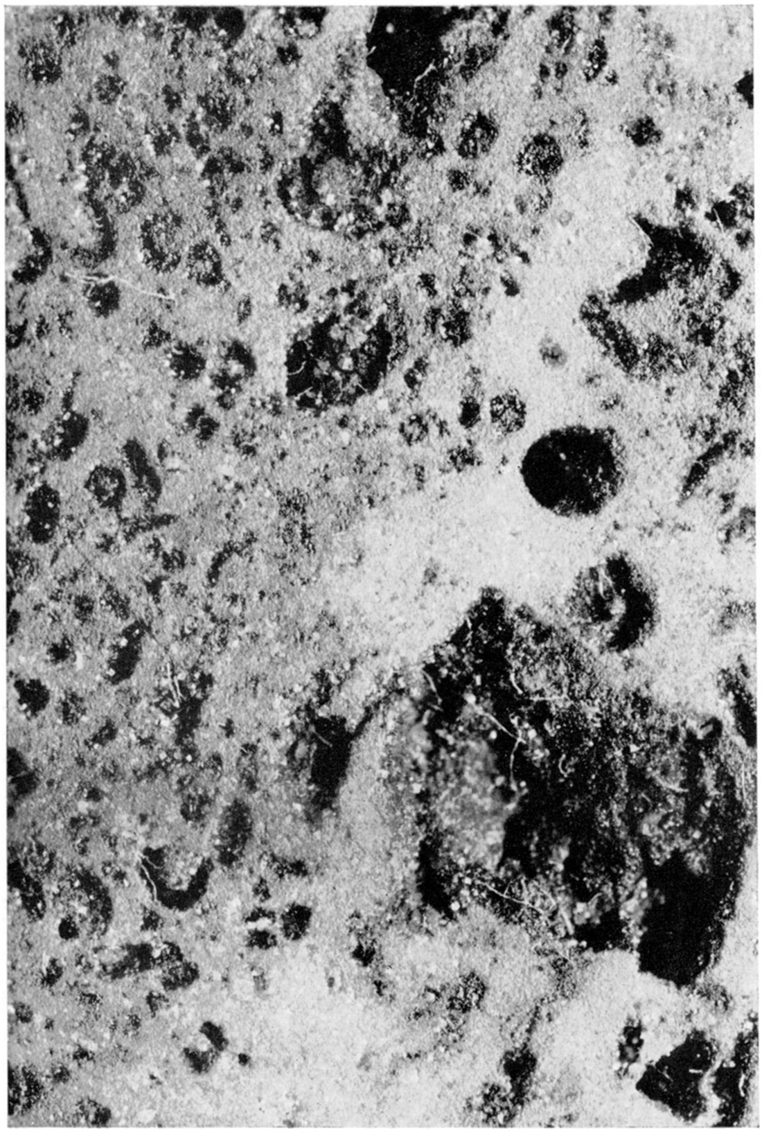
Plate 7—Photomicrographs of cuttings from wells showing clastic character of black shale cave deposits in Mississippian limestones (X 10). The light-colored particles include grains of green shale, light-colored shale, particles of chert, and sand.
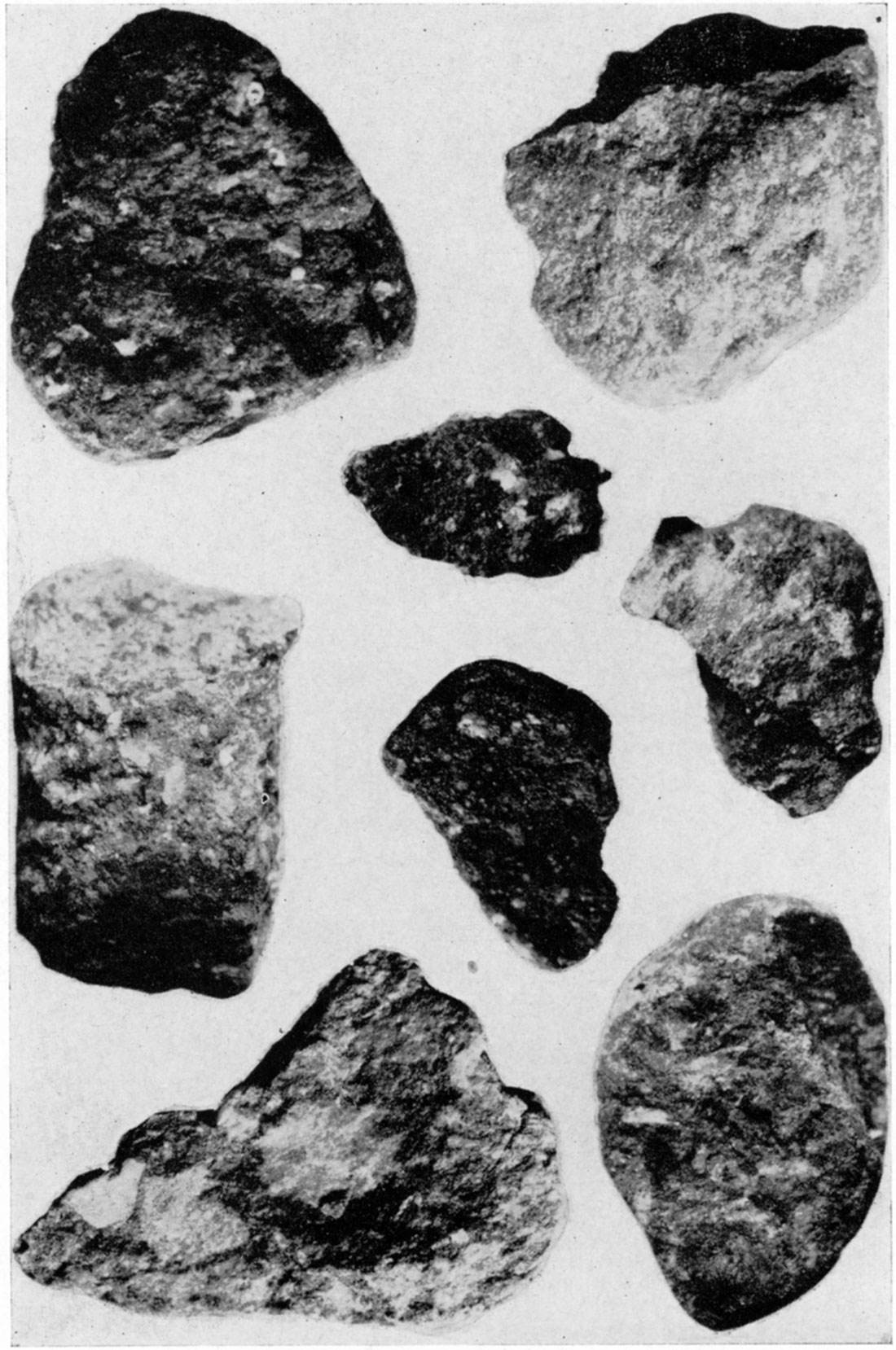
Plate 8—Photographs of chunk samples of McLouth sand shot from wells. A, Oil-stained highly argillaceous sandstone with thin layers and laminae of silty clay (X 1 1/2). B, Oil-stained argillaceous sandstone containing small pebbles and granules of silty clay (X 1 1/2), C, Oil-saturated sandstone containing clay pebbles (X 1).
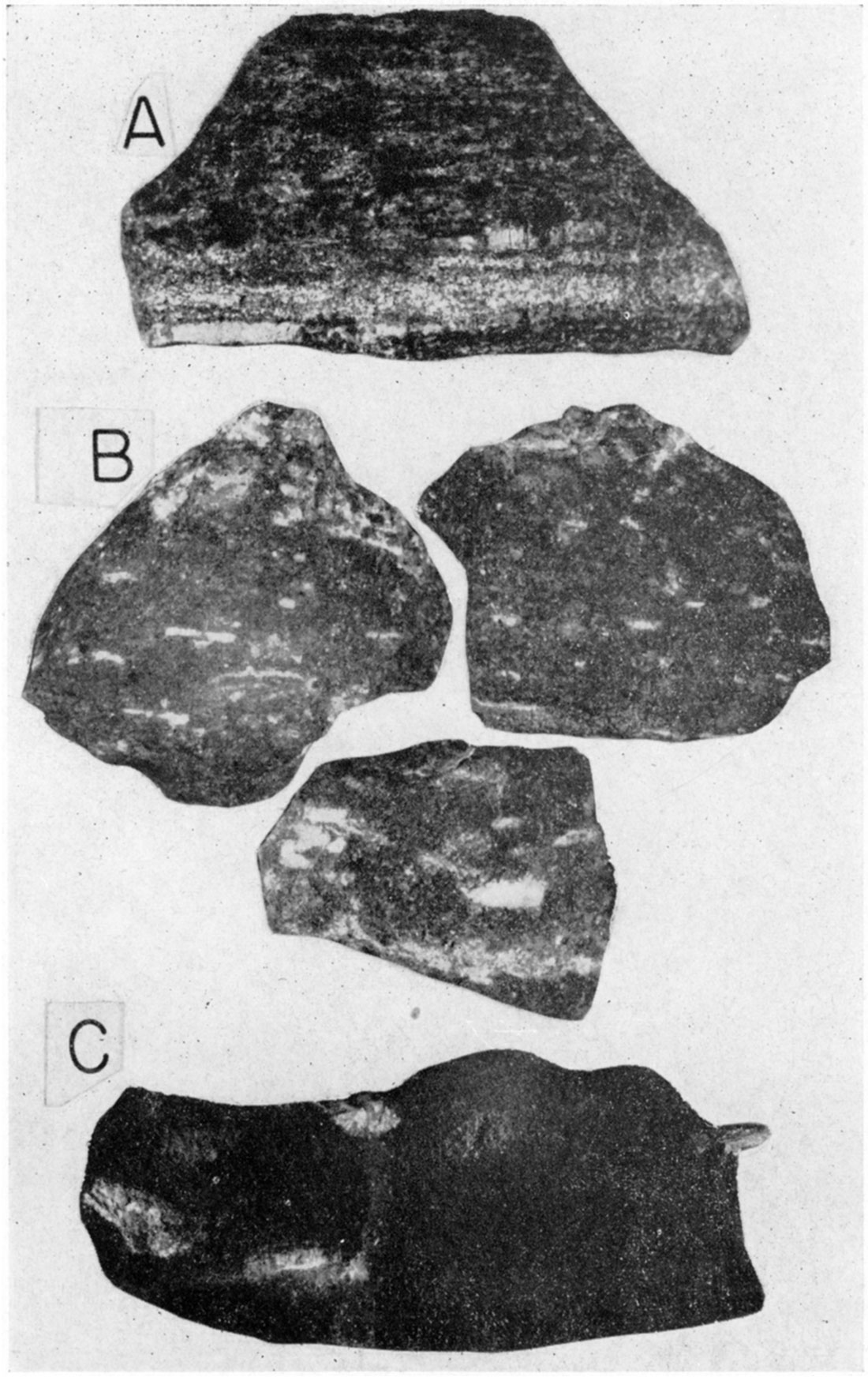
Plate 9—Photomicrographs (X 12) of cable-tool cuttings of wells showing lithologic types represented in the McLouth sand. A, Fine-grained quartzitic sandstone. B, Oil-saturated fine sandstone. C, Quartz sand from poorly cemented coarse sandstone. D, Oil-stained poorly sorted fine to medium-grained argillaceous sandstone.
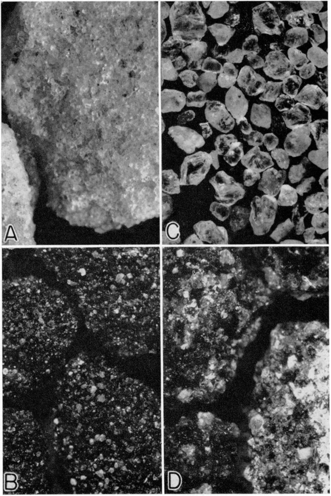
Plate 10—Photomicrographs (X 12) of cable-tool cuttings showing lithologic types represented in the McLouth sand. A, Well-sorted quartz sand from poorly cemented very fine sandstone. B, Slightly oil-stained siltstone. C, Argillaceous fine sandstone with coaly laminae and carbonaceous particles. D, Quartz sand from poorly cemented medium-grained sandstone. E, Argillaceous very fine sandstone with coaly laminae and carbonaceous laminae.
The clay "paste" of the argillaceous sandstone beds is composed of minute flakes and shreds of biotite, chlorite, and sericite, together with clay minerals and fine quartz silt. Whether the fine "hydromica" flakes are predominantly sericite or illite, a clay mineral, could not be determined. In argillaceous sandstones in which the quartz sand grains are for the most part in mutual contact the paste is interstitial and constitutes 10 to 15 percent of the rock mass. In some beds, however, the sand grains tend to be separated and are set in a matrix of clay paste, this material being partially concentrated in thin laminae and lenses.
Cementation
The sandstone and siltstone beds of the McLouth sand vary greatly in degree of cementation and kind of cement. Silica in the form of quartz is the dominant cement; siderite, calcite or dolomite, and pyrite also are represented. In some beds, quartz cement is combined with siderite or a minor quantity of calcareous cement. Locally, siderite or pyrite is the sole cementing substance of sandstone beds, but in no case was calcite or dolomite found to constitute the dominant cement, calcareous material being present only in minor quantity in certain beds. This prevalence of silica cement and general lack of calcareous cement is a notable feature of McLouth sediments. In sandstone beds containing siderite cement, siderite spherulites commonly are present locally.
The degree of cementation in the sandstone and siltstone beds of McLouth sand varies from a poorly cemented condition, in which the rock is easily disintegrated to loose grains by drilling, to a tightly cemented condition, in which case only rock fragments are found in the cuttings. In most of the argillaceous sandstone beds relatively little precipitated cement is present, the sand grains being bound together largely by the clay paste.
Well-sorted Porous Sandstone
Well-sorted porous sandstone occurs locally in the McLouth sand and grades laterally to argillaceous sandstone or quartzitic sandstone. It has intermediate to high porosity and permeability and yields gas, oil, or water in wells of the McLouth field. Off the flanks of the anticlines, wells that penetrated this type of sandstone in the McLouth sand filled with water. Examinations of well samples indicate ,that oil wells in the McLouth sand commonly produce from this type of rocks, and it is probable that the gas wells with large initial open flow and pressure derive gas from similar well-sorted porous sandstone.
Unlike the argillaceous sandstone variety, which generally contains a significant quantity of micas, siderite, and carbonaceous material as well as clay and silt, this type of sandstone consists almost entirely of quartz sand grains that tend to be of uniform grain-size. Accessory detrital minerals of the sand include feldspar, zircon, leucoxene, and others mentioned in the section on Character of sandstone beds. Although different beds are well-sorted, they show variation in grain-size from very fine sand to coarse sand. The sand grains in the fine and very fine sandstones tend to show some degree of rounding, but in many cases the subangular to subround condition has been masked by an imposed angularity produced by precipitation of secondary quartz growths in optical continuity on the surfaces of quartz grains after their deposition. The original rounded outlines of many grains can be detected in thin sections of shot fragments of the rock.
The porosity of this type of sandstone is dependent on the degree of cementation. In places, the rock evidently is poorly cemented, as indicated by the fact that it is completely broken up to loose grains during drilling. Elsewhere, it is fairly well cemented, and the well cuttings consist of aggregates of grains cemented by quartz. Commonly, the quartz cement is precipitated in the form of secondary growths. The name quartzitic sandstone is applied to that variety of sandstone which is rather completely cemented by quartz and therefore has low porosity and permeability. Locally and rarely the sandstone is tightly cemented by siderite or pyrite rather than quartz, in which case the terms sideritic sandstone or pyritiferous sandstone are applied.
Well-sorted porous sandstone varies greatly in hydrocarbon content, ranging from slightly oil-stained sands to sands that are partly or completely saturated with oil. In a few wells the sandstone was found to be impregnated with tar or asphaltic material which acts as a cement and greatly reduces the porosity and permeability; this kind of rock is termed asphaltic sandstone. In most of the oil-saturated sandstones the quartz sand grains show marked development of secondary growths; this suggests that the high porosity which permitted secondary growths also allowed the infiltration of oil.
Argillaceous Sandstone
In the argillaceous sandstone, the most common variety of sandstone in the McLouth sand, the pores between the quartz sand grains are partly to completely filled with silt and clay, and the rock thus is poorly sorted as to grain size. The fine interstitial or matrix material is termed clay "paste," as previously described, and may constitute as much as 30 to 35 percent of the rock mass. Argillaceous sandstone beds have intermediate to low porosity and permeability and usually do not yield water or oil in wells of the McLouth field. In numerous wells, however, this variety of sandstone yields gas, but the wells tend to have small open flows compared with those producing from well-sorted porous sandstone. In many wells, argillaceous sandstone, although unproductive; was oil-stained or even saturated with dead oil.
Argillaceous sandstone commonly contains flakes of mica (muscovite and biotite) and carbonaceous material. Carbonaceous material occurs in the form of scattered particles, representing comminuted plant remains, thin coaly laminae roughly parallel to the stratification, and carbonized remains of leaves, twigs, and other plant structures. Described in the section on Character of sandstone beds are other constituents, including feldspar, heavy minerals, and fragments of siltstone and clay, as well as siderite, that occurs in various forms as a prominent constituent of some argillaceous sandstones.
Argillaceous sandstone varies in grain size from very fine to very coarse sand. In some beds the quartz sand grains show fair sorting, although they were deposited together with silt and clay, but in other beds the sand grains are poorly sorted and heterogeneous in size. The grains of the fine and very fine sandstones tend to be angular; those of the medium and coarse sandstones commonly are subangular or subround. Unlike the well-sorted porous sandstones, in which the roundness of the coarse grains tends to be masked by secondary growths, the argillaceous sandstones maintain the rounded character of the grains and usually do not show secondary growths.
Certain beds of argillaceous sandstone evidently are poorly cemented, as indicated by the fact that the rock is partly or largely broken to loose grains during drilling. Most beds, however, are fairly well cemented by silica and clay paste, in which case well cuttings consist of fragments of the rock. The term quartzitic argillaceous sandstone is applied to the variety that is rather completely cemented by silica and is hard and resistant.
Argillaceous sandstone quite commonly is interbedded with or contains thin layers of siltstone, shale, clay, or even coal, and the contacts between layers tend to be sharp. Zones of argillaceous sandstone in the McLouth sand have been found to grade laterally to sandy siltstone, micaceous silty shale, or clay shale.
Siltstone
The beds of siltstone in the McLouth sand usually are nearly white, light buff, or very light gray. The silt particles are composed largely of quartz, although mica flakes are present in small quantities in most siltstones and are abundant in a few. Some siltstones contain sand grains and are related to and intergradational with argillaceous sandstone. In the variety termed clayey siltstone, the silt particles are set in a matrix of clay. The well-sorted siltstone variety seems to be somewhat porous and, where associated with oil sands, commonly is partly to completely stained or saturated with oil.
Siltstone beds that are hard and resistant as a result of being tightly cemented with silica are termed siliceous siltstone and are analogous to the quartzitic sandstone variety. The term sideritic siltstone is employed for siltstone beds partly or locally cemented with siderite. Siltstone beds very commonly contain abundant reddish-brown siderite spherulites about 1 mm in mean diameter.
Siltstone is interbedded with and is vertically and laterally intergradational with argillaceous sandstone and silty clay shale. Beds designated as siltstone are believed to be massive; well cuttings ordinarily do not give any indication of their having shaly structure.
Massive Clay
Beds designated as massive clay are common in the McLouth sand. They differ from clay shale in having a massive rather than a shaly or laminated structure. Furthermore, they do not have the microscopic micaceous appearance of most shales, a feature caused by the presence in shales of illite, the mica-like clay mineral. Well cuttings from clay beds usually have conchoidal fracture and "slickenside" surfaces, features characteristic of fire clays. It is probable that most of the beds of massive clay in the McLouth belong in the category known to ceramists as fire clay. Some of these beds probably represent the underclays of thin coal streaks in the McLouth.
The clays vary in color from bed to bed but ordinarily they are some shade of light gray-very light neutral gray, light greenish-gray, buff-gray, or light brownish-gray. Some beds have a higher carbonaceous content and are dark gray, and a few are black. Carbonized plant remains are common. Some of the clays contain reddish-brown siderite spherulites. Beds of well-sorted or homogeneous clay are common in the McLouth sand, but the silty clay and sandy clay varieties are rare. In sandy clay the sand grains are disseminated in a clay matrix.
Shale
The variety of shale designated micaceous silty shale is quite common in the McLouth sand. It is diagnostic of certain zones and has marked lateral persistence. It is composed dominantly of quartz-mica silt together with clay and carbonaceous material, and commonly has a laminated appearance due to the alternation of light-gray and dark-gray laminae and to the presence of microscopic partings composed of mica flakes and carbonaceous particles along which the rock tends to break.
Clay shale is the most abundant rock in the McLouth sand. It varies from silty clay shale to uniformly fine clay shale and is light to dark gray to black, depending on the carbonaceous content. Carbonaceous black shale is common. The mica-like clay mineral illite is prese nt and tends to give the shale a very fine micaceous appearance. Reddish-brown siderite spherulites are present in certain of the light-gray shale beds, and in some of the dark-gray and black shales pyrite occurs as disseminated grains or as clusters of crystals. Mica flakes are common, especially in the silty clay shales. Carbonized fragments of land plants and thin coaly laminae occur abundantly in certain of the clay shale beds.
Clay Ironstone
Clay ironstone occurs in the form of thin beds that are uncommon but not rare in the McLouth sand. The clay ironstone is fine-grained, compact, and reddish-brown, and is composed of variable proportions of siderite, clay, silica, and calcium carbonate; carbonaceous material commonly is present. Of rare occurrence in the McLouth are thin layers of red sideritic limestone, a variety of clay ironstone which contains less siderite and more calcium carbonate and effervesces in acid. It leaves an insoluble residue of clay and silica, colored red by finely divided siderite.
Coal
Thin layers of coal occur locally at different horizons in the McLouth sand and are associated with massive clay, clay shale, siltstone, and clay ironstone. It is probable that with increase of clay content, the coals grade into black clay rock which is somewhat similar to black shale but contains so much carbonaceous material as to nearly constitute coal. This black clay was noted in several wells.
Intraformational Breccia
Large shot fragments of McLouth sand obtained from several wells indicate that beds of argillaceous sandstone contain intraformational breccia phases. These consist of angular pebbles of clay and silty clay shale set in a matrix of argillaceous sandstone. The term breccia is not strictly applicable to this kind of rock inasmuch as the pebbles tend to be separated from one another in the sandstone matrix and in some specimens they are rather widely spaced. Thus, this phenomenon is considered to represent an intraformational breccia phase of argillaceous sandstone. Whether this breccia phase is widespread or only of local development was not determined, but it is represented in most of the shot fragments of argillaceous sandstone.
These breccias are truly intraformational in character inasmuch as the pebbles obviously once were part of continuous clay or silt layers that were broken up, reworked, and redeposited in a sandstone matrix. Argillaceous sandstone commonly contains thin layers of clay, siltstone, and shale. In some specimens these layers are undisturbed and unbroken, whereas in others they have been broken up to form breccias, the origin and depositional environment of which is described in the section on Origin of the McLouth sand.
The pebbles range in mean diameter from 4 to 20 mm or more. The silty shale pebbles are distinctly tabular in shape and tend to show preferred orientation which is probably parallel to the surface of deposition. The massive clay pebbles are less tabular and more spheroidal or irregular in shape.
Thickness
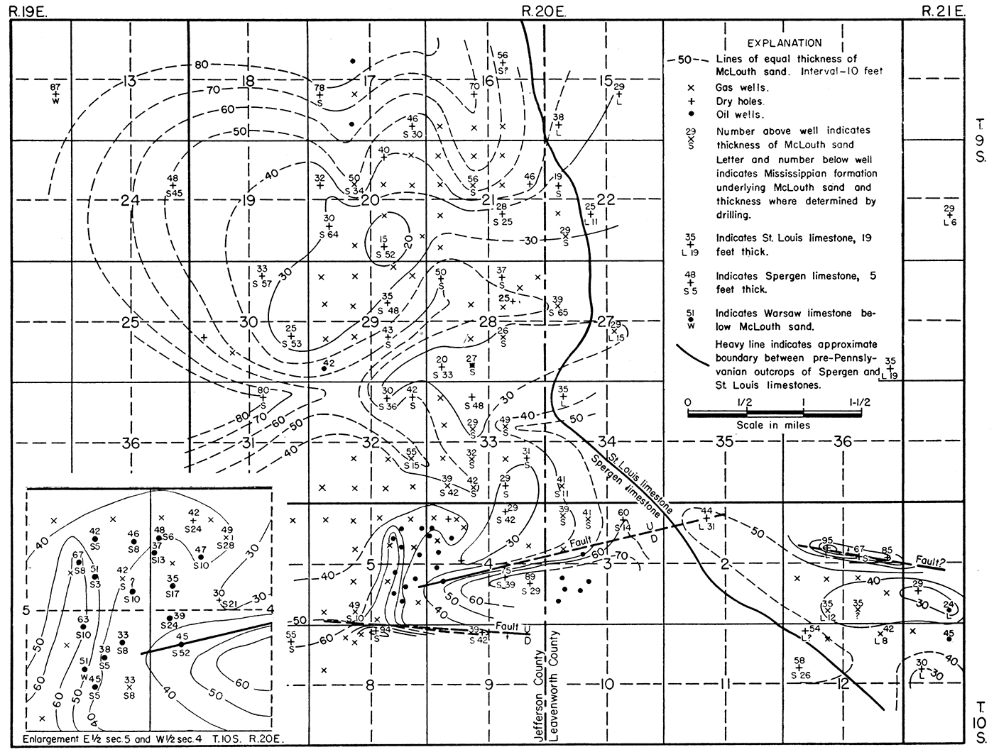
The top of the McLouth sand is a conformable surface and a reliable key horizon, but the top of Mississippian rocks was a deformed and eroded surface when the McLouth sand was deposited. As a result, the McLouth sand has an irregular thickness which ranges from 15 to 95 feet in the McLouth field, as shown by the isopachous map (fig. 14). This variation in thickness is due to two factors: (1) the depositional filling of topographic lows caused by erosion and deformation of the surface of the Mississippian rocks prior to McLouth deposition, and (2) gentle folding and faulting during McLouth time which resulted in local differential subsidence and differential accumulation of McLouth sediments.
Figure 14—Map of McLouth field showing variations in thickness of the McLouth sand by lines of equal thickness and the thickness of the underlying Mississippian formations where determined by drilling. Inset shows details in crowded area in E2 sec. 5 and W2 sec. 4, T. 10 S., R. 20 E.
It is probable that the greater part of the deformation of the eroded Mississippian surface occurred before the beginning of McLouth sedimentation inasmuch as it was preceded by a long period during which the whole region was re-elevated, important structural movements took place, and the region was again lowered to or near sea level. Differential structural movements, however, continued during deposition of the McLouth sand, but the local deformation was probably so gentle that sedimentation kept pace with subsidence without giving much if any relief to the surface of sedimentation. The irregularities of the surface of the Mississippian are in part residual drainage channels on the peneplaned surface and in part are due to erosion that took place after the re-elevation of the region.
It is difficult to isolate and differentiate the results of erosion and deformation on the old pre-Pennsylvanian surface. In some places the influence of one or the other was dominant, but in most areas both are reflected in the thickness of the McLouth sand. In some parts of the field, however, the character and thickness of the underlying Mississippian rocks provide a means of differentiating their influence.
Three Mississippian formations, the St. Louis, Spergen, and Warsaw limestones, are present at the top of the Mississippian in the area of the McLouth field. The St. Louis limestone in the eastern part of the area was beveled toward the west. Its featheredge is indicated on the map (fig. 14) by the line indicating the boundary between it and the underlying Spergen dolomite, which is the uppermost Mississippian formation to the west and throughout the greater part of the McLouth field. The Warsaw limestone, which underlies the Spergen dolomite, was found at the top of the Mississippian in two wells: (1) the Jackson No. 1 Sheldon well (well 9), in the NE SE sec. 14, T. 9 S., R. 19 E., in which the McLouth sand is 87 feet thick, and (2) the V-8 Drilling Company No. 3 McLeod well (well 166), in the SE NW SE sec. 5, T. 10 S., R. 20 E., in which the sand is 51 feet thick. Prior to Cherokee sedimentation, the surface of the beveled St. Louis, Spergen, and Warsaw formations dipped gently westward.
The local variations in thickness of the upper formations of the Mississippian rocks are generally low. The Spergen is thin on the crest of the McLouth anticline and generally thicker on the flanks. Irrespective of the thickness of the McLouth sand, the thinning of Mississippian strata on anticlinal crests indicates pre-Pennsylvanian beveling of pre-Pennsylvanian anticlines. Thinning of the Spergen rocks is not marked on the crest of the North McLouth anticline, probably because the structural relief of this anticline was low.
In places where the McLouth sand is thin and also overlies a thin section of Spergen limestone on a structural crest, the thinning of the McLouth is probably due to its deposition on an anticlinal surface that was rejuvenated before the deposition of the sand. An example of this condition occurs in the Young and Longwell No. 2 McLeod well, in the NW NW SW sec. 4, T. 10 S., R. 20 E., on the crest of the McLouth anticline; in this well the McLouth sand, which is only 39 feet thick, overlies Spergen limestone only 24 feet thick. Similarly, where thick deposits of McLouth sand overlie thick deposits of upper Mississippian formations, synclinal movements or faults of pre-McLouth age are suggested, as in the Sherrod et al. No. 1 Momyer well, in the NW SE sec. 4, T. 10 S., R. 20 E., which penetrated 75 feet of McLouth sand overlying 40 feet of Spergen on the down-dropped side of a fault. An abnormal thickness of Spergen or upper Mississippian rocks overlain by a thin section of McLouth sand probably indicates a topographic high on the old surface. Such a condition occurs in the Sifers No. 1 Leonhard well, in the SE SW sec. 9, T. 10 S., R. 19 E., where the McLouth sand, 60 feet thick, overlies an outlier of St. Louis limestone at least 36 feet thick.
There are some areas where the Spergen is thin or absent and where the McLouth sand, even on structurally high areas, is thick. This condition indicates erosional relief. Thus, in the V-8 Drilling Company No. 3 McLeod well, in the SE NW SE sec. 5, T. 10 S., R. 20 E., on the McLouth dome, the Warsaw limestone was exposed on the Mississippian surface and the McLouth sand is 51 feet thick. This condition is interpreted as being due to pre-Pennsylvanian erosion, in this case partly counteracted by prePennsylvanian structural elevation.
The isopachous map of the McLouth sand (fig. 14) illustrates all phases of thickness variations caused by depositional leveling of the surface of the Mississippian. In general, there is an inverse relation between the thickness of the McLouth sand and the thickness of the Spergen limestone, which indicates in most cases, erosion of the Mississippian. On the McLouth anticline, in the Stark No. 1 Ragan well in the NW1i4 NE sec. 4, T. 10 S., R. 20 E., the McLouth sand is 29 feet thick and the underlying Spergen is 42 feet thick. Approximately half a mile to the west, in the MeLaughlin No. 1 fee well in the NE NW sec. 4, the McLouth thickens to 49 feet and the Spergen thins to 28 feet. Anomalies in the thickness relations in two wells farther west in the NE sec. 5, where the McLouth sand is 51 and 57 feet thick and the Spergen is 3 and 8 feet thick, respectively, are caused by differential deformation of the eroded Mississippian surface and differential accumulation of McLouth beds during McLouth time.
The thickness contours on the structurally high western side of the McLouth anticline indicate the presence of an erosional trough in Mississippian rocks which extends from secs. 7 and 8, T. 10 S., R. 20 E., northward through sec. 5 and into the northwestern corner of sec. 4. In the deeper parts of this trough the Spergen limestone ranges from 3 to 15 feet and averages only about 8 feet in thickness in nine wells, but it is absent in the V-8 Drilling Company No. 3 McLeod well, in the SE NW sec. 5. The overlying McLouth sand in these wells usually exceeds 50 feet in thickness. The McLouth is only 33 feet thick, however, in two wells in the E2 SE sec. 5. These wells evidently are not in the erosional trough because the Spergen is only 8 feet thick and there is no compensating thickening of the McLouth sand. These wells are on the McLouth anticline. Therefore, thinness of the McLouth sand probably is due to the influence of local structural movements before or during McLouth time. Northward and eastward from the erosional trough, the Spergen thickens greatly and the McLouth sand thins to less than 30 feet; the McLouth thins in a westward direction also where, in the Richard No. 1 Sherman well in the NE NE sec. 6, T. 10 S., R. 20 E., it is only 32 feet thick.
Another example of the inverse relations of the thickness of the McLouth sand and the Spergen dolomite occurs in a structurally low area in the northwestern part of the isopachous map. The Spergen is 45 feet thick and the McLouth is 48 feet thick in a well in the SE NE sec. 24, T. 9 S., R. 19 E. About 1 1/2 miles to the northwest, in the NE SE sec. 14, still lower in the structural basin, drilling encountered Warsaw limestone at the base of Pennsylvanian rocks, the Spergen evidently having been completely removed by erosion; here the McLouth has increased in thickness to 87 feet replacing the eroded Spergen. Other examples of this relationship are found on the North McLouth anticline.
The isopachous map furnishes several examples of variation in thickness of the McLouth sand caused by gentle folding and by faulting before and during McLouth sedimentation. Movements along the fault zone on the south side of the McLouth anticline in secs. 3 and 4, T. 10 S., R. 20 E. were evidently important in controlling the thickness of the McLouth sand (fault profile, pl. 4, and structure contour map of the top of the McLouth sand, fig. 8). In two wells in the N2 SE sec. 4, on the downthrow side of the fault, the McLouth sand is 75 and 89 feet thick. Evidence that the fault was active during McLouth time lies in the fact that the upper zones of the McLouth carry across the fault but thicken on its downthrow side. Approximately half a mile in a west-northwest direction from these wells, there is a well on the upthrow side of the fault (cen. W2 sec. 4) in which the McLouth sand is only 30 feet thick. This marked difference in thickness could not have been caused solely by filling of an area of erosional relief on Mississippian rocks because the Spergen dolomite is thicker on the downthrow side where the McLouth is thicker. Movement along the fault may have begun prior to McLouth sedimentation, in which case part of the 45 to 50 foot excess in thickness of the McLouth sand on the downthrow side was due to filling in of a topographic low along a fault scarp.
A similar condition exists on the north flank of the Ackerland pool in sec. 1, T. 10 S., R. 20 E. In a well in the SE NW sec. 1, the McLouth sand is 95 feet thick and is underlain by St. Louis limestone. The finding of St. Louis limestone at the top of Mississippian rocks in a well in which the McLouth is exceedingly thick is contrary to expectations, and the anomaly is increased by the fact that in structurally higher wells to the south the McLouth is 35 feet thick but still overlies the St. Louis limestone which has a maximum known thickness of 36 feet. The anomaly. suggests the presence of a fault, which also is indicated by structure on the top of the McLouth sand (fig. 8).
The effect of gentle folding on the thickness of the McLouth sand is illustrated by wells on the North McLouth anticline treated in table 4. Inasmuch as the Spergen dolomite is of rather uniform thickness in these wells, the differences in thickness of the McLouth sand probably are the result of gentle folding during McLouth time rather than filling of erosional relief, for the several lithologic zones of the McLouth, which are thick in the structurally deeper wells, here carry across the structural high. In the second well in table 4, the top of the McLouth sand is 9 feet deeper and the McLouth is 10 feet thicker than in the first well; in the third well the top of the McLouth is 18 feet deeper and the McLouth is 18 feet thicker than in the first well. These observations lead to the conclusion that the structure shown by the top of the McLouth sand and its thicknesses are the result of structural movements that began before the close of McLouth deposition and were revived during later Pennsylvanian time, an assumption that is supported by evidence from other parts of the field.
Table 4—Relation of thickness of McLouth sand to structure.
| Location of well in T. 9 S., R. 20 E. |
Thickness of McLouth sand, feet |
Altitude of top of McLouth sand, feet below sea level |
Thickness of Spergen dolomite, feet |
|---|---|---|---|
| SW SE sec. 20 | 15 | 383 | 52 |
| NE SE sec. 30 | 25 | 392 | 53 |
| NW NE sec. 30 | 33 | 401 | 57 |
The structure contour map of the top of the McLouth sand (fig. 8) shows a pronounced saddle between the McLouth anticline and the North McLouth anticline that extends northeastward from secs. 30 and 31 through parts of secs. 29 and 28, T. 9 S., R. 20 E. This structural saddle is represented on the isopachous map of the McLouth sand by a belt, trending in the same direction, in which the McLouth sand is up to 80 feet thicker than it is on the anticlines to the north and south.
Most of the producing wells of the McLouth field were not drilled completely through the McLouth sand, and the total thickness of the McLouth in them is not known. The actual thickness penetrated followed by a plus sign is shown on the isopachous map in some wells where the partial thicknesses are significant.
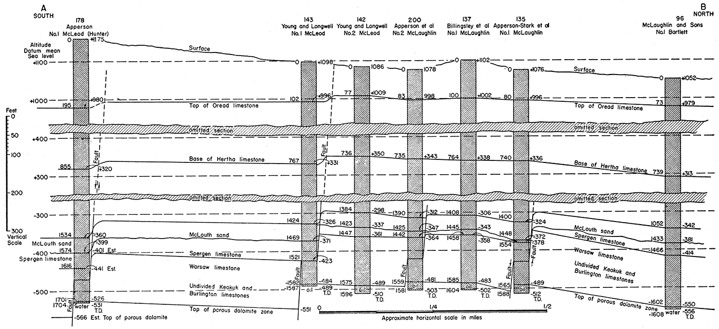
Figure 15—Diagrammatic cross section of the McLouth field along line A-B (figs. 10, 11, pl. 3) showing structural relations of Pennsylvanian and Mississippian rocks. The structural relief increases with depth. Some faults in the Mississippian die out in the lower Pennsylvanian.
The numbers at right of well columns indicate altitudes above and below sea level. The numbers at left of well columns indicate depths below surface. The numbers above well names refer to the numbers of wells as listed in table 27.
Lithologic Zones
The subdivision of the McLouth sand into lithologic zones which, although showing lateral lithologic variation, may be traced throughout large parts of the field, has been made possible by the examination of cable-tool cuttings, usually taken at 5-foot or smaller intervals in the McLouth sand, and information from drillers logs. Sandy zones and shale zones alternate vertically in the McLouth. As shown by the block diagram (pl. 4), the McLouth contains four sandy zones, one or more of the upper three of which yield gas, oil, or water. They are designated as sandy zones because they are not everywhere represented by sandstone; locally, they consist of sandy siltstone or sandy shale or are represented by thin sandy laminae in beds of siltstone, shale, or clay. The four sandy zones are separated by three non-sandy zones composed of varying amounts of siltstone, clay, clay ironstone, coal, and several varieties of shale. Samples from the Sherrod and Workman No. 1 Seitz well, in the SW NE sec. 32, T. 10 S., R. 19 E., and the O'Dea No. 1 Borst well, in the SW NE sec. 1, T. 10 S., R. 20 E., indicate that in these wells the McLouth does not contain any beds of sandstone, the sandy zones being represented by thin sandy laminae in beds composed of fine clastic material. The distinguishable lithologic zones are designated from the bottom up by letters A to G.
The sandy zones of the McLouth are not shoestring sand bodies but are blanket deposits, although they wedge out and vary considerably in lithology within the McLouth field. The lowermost zone (A) is limited to the eastern part of the field and wedges out westward (pl. 4) , whereas the second sandy zone from the bottom of the McLouth (C) is limited to the western and central parts of the field, where it produces gas, and pinches out eastward. The upper two sandy zones (E and G) , which are separated by a thin shale zone, are present throughout the field; the top of the uppermost zone is the top of the McLouth sand, and provides a reliable key horizon for structure mapping. The intervening shale zones (B, D, and F) consist of shale, clay, and siltstone and are shown by solid black bands on the block diagram.
Detailed lithologic study and zonation of the McLouth make possible the lithologic interpolation between wells. This procedure is of potential value in guiding a drilling program. The well numbers used in the following description of lithologic zones refer to the well index numbers employed in the block diagram.
Zone A—The lowermost subdivision of the McLouth sand, Zone A, is composed dominantly of argillaceous sandstone and is limited to the easternmost part of the field, where it overlies Mississippian rocks from which it is separated by an erosional unconformity. It was found in wells 105, 145, 181, 182, 183, and 194 (pl. 4) and in other wells not shown on the block diagram. This zone pinches out westward and is not present on the crests or flanks of the major anticlines on which the McLouth and North McLouth pools are situated. Where Zone A pinches out in a westward direction, the entire McLouth section tends to become thinner. This thinning is due in part to the wedging out of the basal sandstone zone. In well 194, in which the McLouth has a total thickness of 65 feet, Zone A is about 17 feet thick. This zone evidently pinches out westward from this well because in well 187 there is no basal sandstone and the McLouth totals only 46 feet. In well 183, the McLouth is 55 feet thick and Zone A is about 10 feet thick, whereas in well 186, approximately 2 miles to the southwest, the McLouth is only 18 feet thick, and the basal sandstone is absent. In wells 145 and 144, south of the fault on the south flank of the McLouth pool anticline, the McLouth sand is thick, 89 feet in well 145 and 75 feet in well 144. The difference in thickness of the McLouth in these wells is largely due to the fact that the basal sandstone is present in well 145 but is absent to the west in well 144, where black shale that commonly overlies Zone A rests directly on Mississippian rocks.
Zone A consists predominantly of argillaceous, very coarse-grained sandstone, the pores between the coarse quartz sand grains being largely filled with silt and clay material. In places, the argillaceous sandstone is partly cemented by silica and is somewhat quartzitic. This zone has not yielded gas, oil, or water, probably because of low permeability due largely to its argillaceous and in some places cemented or quartzitic character.
Zone A shows much lateral variation in lithology (pl. 4). In well 194 (SW NE sec. 19, T. 10 S., R. 21 E.) it is about 17 feet thick and consists chiefly of argillaceous, very coarse-grained sandstone which is poorly cemented and for the most part broken up during drilling to loose sand grains which are angular to subangular and show good size sorting. In the basal 5 feet, however, the sandstone evidently is interbedded with dark-gray to black clay shale and light-brownish-gray siltstone. Coarse weathered grains of chert were noted at the base of the zone. In well 183, 3 miles to the west-northwest, Zone A is about 10 feet thick and contains sand similar to that found in well 194; however, well samples indicate that the argillaceous sandstone here is interbedded with dark-gray to black clay shale, coal, massive clay, and minor beds of clay ironstone. In well 145 (NE SE sec. 4, T. 10 S., R. 20 E.), the basal sandstone zone is approximately 10 feet thick and consists of coarse-grained angular sand. The sandstone is less argillaceous here than elsewhere, contains beds of oil-stained siltstone, and is saturated with oil. This well is in the vicinity of oil wells producing from a higher zone in the McLouth sand and is a short distance south of and on the downthrow side of the fault zone on the south flank of the McLouth anticline. Here the basal sandstone zone contains abundant angular chert fragments, some of which show a banded structure typical of some of the chert in the Spergen dolomite. This chert may have been derived from residual material of the Spergen on the upthrow side of the fault to the north where the basal sandstone zone is absent. There is evidence that this fault was active during the deposition of the McLouth sand. In well 182, situated 3 miles to the east in NW NE NE sec. 12. T. 10 S., R. 20 E., Zone A is about 15 feet thick and consists of highly oil-stained argillaceous coarse-grained sandstone with thin beds of oil-stained siltstone. A short distance southwest from this well, in well 181, Zone A is markedly different in lithology and is approximately 25 feet thick; the bottom part, about 10 feet thick, does not contain sand but consists of black carbonaceous clay, laminae of coal, and beds of siltstone and clay ironstone. The upper part of the zone, the remaining 15 feet, consists of layers of quartzitic silty coarse sandstone interlaminated with black shale and coal, massive clay, white siltstone with siderite spherulites, and clay ironstone. In well 105, more than 3 miles to the north, Zone A is only about 4 feet thick and consists of quartzitic silty slightly oil-stained sandstone.
Throughout the basal sandstone zone the quartz sand grains tend to be very coarse-grained and angular to subangular, although a few range through subround. Furthermore, they tend to be well-sorted or uniform in size, although the pores between them are filled with argillaceous material. Large quartz granules were noted at the base of the zone in several wells. Angular detrital chert grains, for the most part weathered and probably derived from Mississippian limestone, are present in the sand but are abundant only at the base.
Zone B—This zone consists of several types of shale, clay, and siltstone, and, unlike Zone A, does not contain beds of sandstone. The rock types are nonporous and nonpermeable, and the entire zone is represented on the block diagram (pl. 4) by a solid black pattern. Zone B is present throughout the greater part of the McLouth field and directly overlies Mississippian rocks on the McLouth and North McLouth anticlines and elsewhere in the central and western part of the field. In the easternmost part of the field, however, it is separated from Mississippian rocks by the underlying sandstone and associated rocks of Zone A.
Zone B is characterized by marked lateral variation in lithology. Micaceous silty shale, composed dominantly of quartz-mica silt, clay, and carbonaceous material, is the diagnostic lithologic type. Medium- to dark-gray to black clay shale which contains carbonized leaves and other plant remains also is common, especially in the lower part of the zone. The black shale beds in places contain pyrite. Another important rock type is massive clay, some of which is black. In a few wells the zone is composed almost entirely of a single one of these lithologic types, but in most wells there is interbedding of other types. Minor rock types of this zone, described in the section on Lithology, include sideritic white siltstone and thin beds of clay ironstone and coal. Coarse angular grains of residual chert from the Mississippian and coarse quartz sand grains and granules are common at the base of Zone B where it overlies Mississippian rocks.
Zone B is 8 to 10 feet thick throughout the greater part of the McLouth field. In well 101, in the SW SE sec. 33, T. 9 S., R. 20 E. on the McLouth anticline, the zone is only 2 or 3 feet in thickness; in well 139, a quarter of a mile to the south in the NW NE sec. 4, T. 10 S., R. 20 E., Zone B is not represented, and the sandstone of Zone C containing a show of gas rests directly on Mississippian rocks. Zone B increases in thickness on the south or downthrow side of the fault on the south flank of the McLouth pool where in wells 145 and 183 it merges with Zone D, the sandstone beds of Zone C having pinched out (pl. 4).
Zone C—This zone is present in the western half of the area shown in plate 4 and consists of sandstone with thin beds of shale and siltstone. This sandstone zone pinches out eastward in secs. 3 and 4, T. 10 S., R. 20 E. and in secs. 20, 28, 29, and 33, T. 9 S., R. 20 E. Westward from this area it ranges in thickness from 6 to 30 feet. The sandstone beds of Zone C vary from well-sorted porous sandstone to highly argillaceous sandstone, intermediate stages being present. In a few wells, part of the zone consists of quartzitic sandstone, but the sandstone beds are generally slightly cemented by quartz.
On the northwest flank of the McLouth anticline, Zone C is believed to form a stratigraphic trap from which comes most of the production of the numerous gas wells in the NW sec. 4 and the N2 sec. 5, T. 10 S., R. 20 E. and along the southern border of sec. 32, T. 9 S., R. 20 E. In this area, Zone C, consisting of well-sorted porous sandstone, pinches out eastward on the McLouth anticline, as indicated by wells 53, 94, 99, 125, and 145 (pl. 4). In well 89, with an initial open flow of 12,250 M cubic feet, the upper part of Zone C was penetrated and yielded most of the gas. Southeast of this well, in well 131, most of the initial open flow of 10,200 M cubic feet came from the upper 16 feet of Zone C. Still farther southeast, in well 134 which had an initial open flow of 8,500 M cubic feet, the total thickness of Zone C, 24 feet of porous sandstone, was penetrated and yielded gas. In well 140, a little more than a quarter of a mile to the east from well 134, Zone C thins to about 5 feet of porous sandstone and had only a show of gas (88 M cubic feet); in well 121, about half a mile farther east, the zone is nonproductive and is represented by only about 3 feet of highly argillaceous sandstone. The gas production from this well comes from a higher sandstone zone in the McLouth. Thus, along the line of these wells, Zone C thins and becomes argillaceous and nonproductive in an eastward direction. The stratigraphic trap in this zone on the northwest flank of the anticline is indicated by other wells not shown on the block diagram.
Well-sorted, porous sandstone developed locally in Zone C yields gas, oil, and water in other parts of the field. In well 9, in the NE SE sec. 14, T. 9 S., R. 19 E., the cuttings from Zone C consist entirely of loose well-sorted grains of quartz sand. The zone is 30 feet thick and carries water. In well 101, in the SW SE sec. 33, T. 9 S., R. 20 E., there was an oil show in Zone C which here is 10 feet thick and consists of porous, oil-saturated sandstone. Eastward from this well, the sandstone of this zone pinches out, and in well 103, half a mile to the east, the zone is represented by oil-saturated sandy siltstone which gave a small show of oil.
Aside from the areas of porous productive sandstone described in the preceding paragraphs, Zone C consists largely of argillaceous sandstone which is commonly interstratified with layers of siltstone and shale. In several wells the argillaceous sandstone was oil stained but failed to produce oil.
Zone D—The siltstone, shale, and associated beds of Zone D are similar to those of Zone B. This zone is present throughout the McLouth field and ranges in thickness from 4 to 10 feet. White siltstone, certain beds of which contain siderite in the form of spherulites and irregular shapes, is the characteristic lithologic type, especially in the eastern half of the area shown in plate 4. Some of the siltstone beds are sandy. Micaceous silty shale also is common in the zone throughout the field. Light- to dark-gray to black clay shale and beds of massive clay and clay ironstone are present locally.
Zone D directly overlies Zone B in the eastern part of the field, where the intervening sandy Zone C has thinned out. Inasmuch as these two shale zones are composed of similar lithologic types, it is impossible to distinguish them in this part of the field. Zone D increases in thickness on the south or downthrow side of the fault on the south flank of the McLouth pool, where it merges with Zone B to form a single body of shale, siltstone, and clay which is about 40 feet thick in wells 145 and 183.
Zone E—The sandstone and associated beds of Zone E are present throughout the McLouth field and range in thickness from 4 to 16 feet, usually 6 to 8 feet. Argillaceous sandstone is the dominant lithologic type. The sands range widely in grain size from very fine to very coarse. The zone contains laminae and thin beds of siltstone and shale. Carbonaceous material in the form of scattered particles and coaly laminae is abundant.
Locally, where porous sandstone phases of the zone occur in favorable structural positions, wells drilled to this zone yield large initial open flows of gas. Oil is found in some localities. In most wells of the field the. sands of Zone E are oil stained, and in several wells the sand is impregnated with asphaltic material. In well 194, in the SW NE sec. 19, T. 10 S., R. 21 E., the zone consists entirely of water-bearing well-sorted fine sand. Porous sandstone is developed only locally, however, and sand grades laterally into argillaceous sandstone which is commonly oil-stained but does not produce oil. Gas wells producing from argillaceous sandstone have smaller initial open flow than do wells that encountered porous sand in this zone.
In the North McLouth pool several wells found shows of oil, and two wells (21 and 23) in sec. 17, T. 9 S., R. 20 E. produce oil from Zone E. In the oil wells south of the fault zone on the south flank of the McLouth pool (sec. 3, T. 10 S., R. 20 E.), Zone E is thick and consists of well-sorted coarse porous sandstone containing thin layers of siltstone and shale. In these wells oil is produced from Zone E and from Zone G.
Zone F—Black clay shale is the dominant rock type of Zone F, which extends throughout the area of the field and averages only about 5 feet in thickness. White siltstone and dark-gray to black massive clay occur locally, either interbedded with black shale or comprising the entire thickness of the Zone. Well samples indicate that Zone F thins to 2 feet or less in parts of the field. The difference in oil and gas content of the sandstone in the underlying Zone E and the sandstone in the overlying Zone G indicates that the shale of Zone F forms an effective barrier between these producing zones. In several wells in the northern part of the North McLouth pool (secs. 17, 20, and 21, T. 9 S., R. 20 E.), the uppermost zone (G) produces gas or gives shows of gas, whereas in the same wells Zone E produces oil or gives shows of oil. In numerous wells in other parts of the field, Zone E produces gas, and Zone G is nonproductive.
Zone G—The sandstone and associated beds of Zone G are present throughout the McLouth field and form the top of the McLouth sand, a reliable key position for structure mapping. This zone averages about 5 feet in thickness and consists almost entirely of fine- to medium-grained argillaceous sandstone containing laminae and thin beds of dark-gray to black shale. The sandstone beds are carbonaceous and commonly contain carbonized plant fragments and coaly laminae. Locally, the sandstone beds are partly cemented by quartz and are somewhat quartzitic. In many wells of the field, this zone was found to be capped by a thin layer of nearly white quartzitic sandstone; this cap rock is dense and nonpermeable and has remarkable lateral persistence.
The sandstone beds of Zone G commonly are oil stained or saturated with dead oil, and in a few wells shows of oil were obtained from this zone. Production of oil from this zone is limited to the wells in sec. 3, T. 10 S., R. 20 E., south of the fault zone. Because of the argillaceous character of the sandstone, only shows of gas were obtained from Zone G throughout the greater part of the field. Zone G is the principal gas-producing zone, however, in the northern part of the North McLouth pool and in the Ackerland pool (secs. 1 and 12, T. 10 S., R. 20 E.) where the sandstone beds are less argillaceous and more porous.
Prev Page—Structure || Next Page—Cherokee and Distribution
Kansas Geological Survey
Comments to webadmin@kgs.ku.edu
Web version July 2019. Original publication date June 1944.
URL=http://www.kgs.ku.edu/Publications/Bulletins/53/06_sand.html