![]()
Prev Page—Producing Zones || Next Page—McLouth Sand
Structure
Resume of Structural History of Northeastern Kansas
Inasmuch as the development of the regional structure of northeastern Kansas has been presented in detail in Bulletin 51 (Lee, 1943), only a brief resume of the regional structure will be given here as a background for understanding the structural conditions of the McLouth field.
From late Cambrian time to the end of Arbuckle time the central Ozark region of Missouri was subsiding and southeastern Nebraska was rising. These movements were intermittent, and deposition and erosion alternated many times. The whole region was at times exposed, but exposure was more frequent and erosion greater toward the rising area to the northwest. Submergence was also general over the whole region at times, but it was more frequent and deposits were thicker in the central part of the Ozark basin than toward its northwestern margin. These events resulted in a great accumulation of sediments more than 3,000 feet in thickness in the central Ozarks, and a wedging out of the deposits toward southeastern Nebraska. The McLouth field occupies a position between. the subsiding area in southern Missouri and the rising area in southeastern Nebraska. The deposits from the granite to the top of the St. Peter sandstone have a thickness of about 700 feet in the McLouth field.
From the end of St. Peter time through the deposition of Chattanooga shale the relation of rising and sinking areas was reversed, Southeastern Nebraska was sinking and the Ozark region was rising. Most of the formations deposited within this time interval thicken toward the northwest. The beginning of the Chautauqua arch, which is a broad westerly to northwesterly trending fold in southeastern Kansas, seems to have been initiated contemporaneously with this change in isostatic balance. The McLouth field occupies a position which during this period was again intermediate but between the rising area to the southeast and the subsiding area toward the northwest. The aggregate thickness of St. Peter, Kimmswick, Maquoketa, Devonian, and Chattanooga rocks in the McLouth field is 430 feet.
Two very important time breaks occurred during the deposition of these rocks. One preceded the deposition of the Devonian during which there was a pronounced elevation toward the southeast with beveling of all the older rock formations. The other, of similar character, preceded the deposition of the Chattanooga shale when similar re-elevation of the surface toward the southeast was followed by widespread beveling of the Devonian and further erosion of the earlier rocks to the southeast.
Only a small amount of structural deformation occurred during deposition of the Mississippian rocks, although the thickness and distribution of the Mississippian formations and overlap of the younger Mississippian rocks toward the north imply a slight subsidence of southern Kansas. The initial movement of the Nemaha anticline seems to have occurred early in Mississippian time, but folding along the Nemaha anticline was unimportant until after deposition of the Mississippian limestone, when the crest of this anticline was raised several hundred feet in some places. Several other less pronounced parallel anticlines of great importance in oil and gas accumulation, such as the Voshell anticline of central Kansas, were also developed at the same time. The erosion that followed the development of these anticlines beveled the tilted beds and reduced the greater part of Kansas to a broad flat peneplain. Before the deposition of the first Pennsylvanian sediments, the base-leveled surface was disturbed by renewed structural movements particularly prominent along the Nemaha anticline and on its eastern flank. Though renewed folding took place along its crest, the most important feature of the new movements was a downward displacement of several hundred feet on the east flank of th~ Nemaha anticline. This displacement resulted in an escarpment produced in some places by faulting and in others by sharp monoclinal dip. It was accompanied by gentle downward warping of the peneplaned surface east of the escarpment. These structural movements produced the Cherokee basin in southeastern Kansas (the northern extremity of a very deep structural trough in eastern Oklahoma) and the Forest City basin, a relatively minor depression in northeastern Kansas separated from, but in northward continuation with, the Cherokee basin.
A comparison of thickness maps of early Pennsylvanian rocks and of Mississippian rocks and the distribution of Mississippian formations indicates that the pre-Pennsylvanian surface in northeastern Kansas was marked by broad shallow valleys. It is uncertain whether this topography is the result of incomplete peneplanation or of erosion that occurred after deformation of the peneplaned surface. The drainage basins seem to have been eroded on an otherwise flat surface suggesting that they represent post-peneplain erosion. However, there are areas in which thin outliers of younger formations occur in places where the lower Pennsylvanian rocks are thin (fig. 17). This unquestionably indicates the survival of unreduced mounds on the surface of the peneplain. Erosion of drainage basins surviving on the peneplain was probably renewed after the deformation of the peneplain.
The deepest part of the Forest City basin received the oldest and thickest Cherokee deposits, and its configuration is roughly shown by the thickness of the interval between the base of the Hertha limestone and top of the Mississippian rocks (pl. 1). The crest of the Nemaha ridge was not completely submerged until Bronson or Kansas City time, for rocks of this age overlie granite on the northern part of its crest. The structural movements initiated by the re-elevation and deformation of the peneplaned surface continued active throughout Pennsylvanian time. The increments of structural deformation were small but are determinable by comparison of the structure of each successive datum bed, for, after each period of differential folding, the succeeding strata were deposited in essentially horizontal positions. These movements resulted in an increase in the sharpness of nearly all the structural features with depth so that very low anticlines in the surface rocks are found to overlie similar structures of greater closure in the older rocks.
The Forest City basin and the Cherokee basin were at first separated by a broad flat arch (Lee, 1939, pl. 2, p. 24), which will be referred to as the Bourbon arch. This arch extended northwest from Bourbon county, Kansas, and was approximately parallel to the Chautauqua arch which is not known to have been active at this time. The Bourbon arch was submerged in middle Cherokee time, and during the remainder of Pennsylvanian time the Forest City basin was merely the northern end of the Cherokee basin.
The final major structural event affecting northeastern Kansas, as well as the rest of Kansas and adjoining states, was a tilting of the whole region toward the northwest. The geologic cross section from western Missouri to western Kansas prepared by Betty Kellett (1932) shows that the westward-dipping beveled Permian and Pennsylvanian strata of central Kansas were covered by nearly horizontal Cretaceous rocks. Mohr (1939) has presented a north-south cross section from Texas to Nebraska. This cross section also shows beveled upper Permian rocks in Kansas overlain by Cretaceous rocks along a component of the regional dip.
The Kellett section shows very clearly the close parallelism of Permian and Pennsylvanian strata and the angular unconformity between Permian and Cretaceous rocks. The Cretaceous rocks are still essentially horizontal and it follows that the regional dip in eastern Kansas was developed during the hiatus between the Permian and the Cretaceous. Since the deposition of the Cretaceous, the whole region has been elevated several thousand feet without disturbing materially the original horizontal position of the Cretaceous, although local structures have been imposed upon it. The whole region has been subjected to long continued erosion during and since the elevation, for partial peneplains and river benches reveal many stages of re-elevation during the erosional period.
Relation of McLouth Field to Regional Structure
The position of the McLouth field in relation to the regional structure is shown in figures 4 and 5. Figure 4 shows by 50-foot contour lines the present structural configuration of the top of the Mississippian rocks. This surface was originally an approximately flat peneplaned surface although it was traversed in some parts of the region by broad shallow valleys. Its present configuration is the result of all the deformational movements that have occurred in this area from the completion of the peneplain to the present. These include the re-elevation and progressive growth of the Nemaha anticline and the escarpment on its east side, the subsidence of the Forest City basin, local folds, and the pre-Cretaceous regional dip which modified the expression of all the earlier structural features in relation to sea level.
Figure 4—Map of northeastern Kansas showing regional structure of the top of the Mississippian limestone and so far as known the distribution of Mississippian formations on the pre-Pennsylvanian surface in the eastern part of the area.
The approximate contacts between areas of outcrop of the different Mississippian formations in the eastern part of the area are indicated by heavy lines.
Contour interval. 50 feet. Crosses show the locations of wells from which samples have been studied, Dots show the locations of wells for which data are available from well logs.
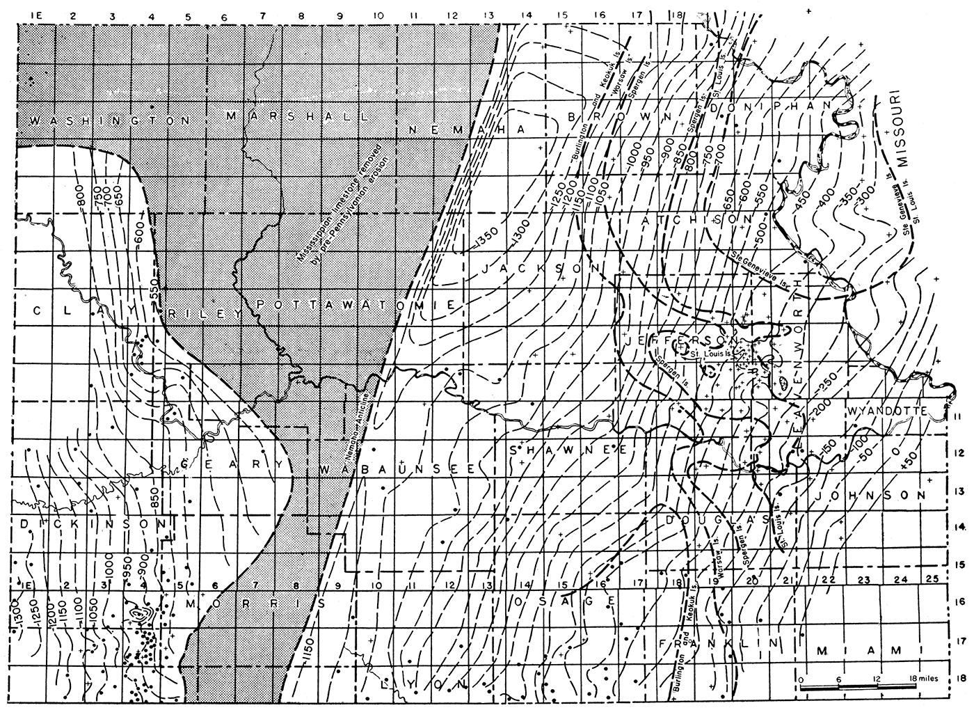
Figure 5—Map of northeastern Kansas showing regional structure at the base of the Hertha limestone. The structure at the base of the Hertha represents only the structural deformation that occurred after the deposition of the Hertha limestone.
Contour interval, 50 feet. Broken lines indicate structure determined from scattered wells. Full lines, mainly in the McLouth field, indicate structure determined from closely spaced wells. Crosses indicate wells for which data are available from sample logs. Dots show the wells for which data are available only from well logs.
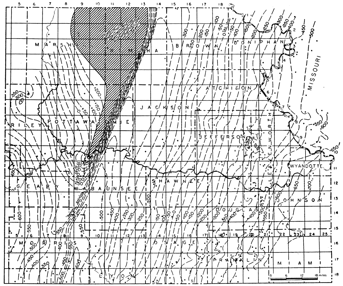
Similarly, figure 5 shows the structural deformation of the originally horizontal base of the Hertha limestone. This datum plane has, however, been affected only by post-Hertha structural movements, most of which, except the regional dip, are the rejuvenation of earlier structural features.
Plate 1 shows the thickness of rocks between the base of the Hertha limestone and the top of the Mississippian rocks by 50-foot lines of equal thickness ("isopachs"). Inasmuch as the base of the Hertha was deposited upon an essentially flat surface, the thickness map shows the configuration of the Mississippian surface at the time the Hertha was deposited. The isopachous lines, therefore, express the deformation of the Mississippian surface from peneplanation to beginning of Hertha time, plus the gentle topographic features of this ancient surface. The deepest part of the Forest City basin thus indicated lies 15 to 25 miles east of the Nemaha escarpment. In the structure maps, however, the deepest part of the basin lies at the base of the escarpment. This change in the apparent position of the syncline in the structural maps is the effect of regional dip, which gave the reference plane of the thickness maps an altered relation to sea level. The original geographic position of the bottom of the Forest City basin syncline is indicated by the thickness map. The structure maps show the regional structure in relation to sea level after the development of regional dip.
The thickness map (pl. 1) also shows by 50-foot thickness lines a broad oval northward-trending area of thinning on the eastern side of the basin which represents a broad arch on the surface of the Mississippian. The study of the structure of the McLouth field, to be discussed later, reveals that the relief of the pre-Pennsylvanian surface in the field is mainly structural, the erosional elements being of minor importance, Inasmuch as the McLouth area lies at the crest of the arch, it is believed from, analogy that the thinning of the lower Pennsylvanian rocks in Atchison, Jefferson, and Leavenworth counties represents in large part a structural arching of the Mississippian surface. Parts of the area of thinning, however, are not part of the arch. The Mississippian in these counties, as shown in plate 1, is underlain mainly by Spergen and St. Louis rocks beveled by post-Mississippian peneplanation, but outliers of St. Louis limestone occur west of the field in T. 10 S., R. 19 E. and in T. 9 S., R. 18 E. The thinning of the lower Pennsylvanian rocks over the St. Louis in these townships is, therefore, due to topographic relief and cannot be interpreted as the expression of structure.
The expression of the southern end of the arch is lost in an area of broad valleys shown on the lower Pennsylvanian thickness map by the dendritic pattern of the thickness contours in Douglas and Franklin counties. In this area the topographic features, which are reflected also in the areal distribution of the Mississippian formations, obscure the structural features as expressed by the thickness lines. After eliminating the areas of thinning in central Jefferson county due to outliers of the St. Louis limestone, the trend of the arch upon which the McLouth field is situated seems to be toward the north.
The structure map of the base of the Hertha limestone shows deformation that has taken place since the deposition of that formation. The contour lines represent both the amount of post-Hertha subsidence of the Forest City basin and local deformation, both of which have been modified by regional dip. The local deviations from regularity of dip are presumed to be the expression of low pre-Cretaceous folds modified by regional dip. The expression of most of these folds is vague and their configuration is uncertain, for the contour interval is large, the wells are sparsely distributed, and many of the wells were drilled without consideration of structural conditions. Restoration of this surface to its attitude prior to the development of the regional dip, as discussed in the chapter on the structure of the McLouth field, might reveal broad anticlinal areas worthy of detailed study to bring out local structural features of value in the search for oil and gas.
Examination of the contour lines reveals that there is a decrease in the rate of westerly dip in a belt 8 to 10 miles wide extending southward from Atchison county through the McLouth field into Douglas and Franklin counties. The flattening of the dip in this belt seems to be the expression of a low anticlinal fold which has been reduced by regional dip to a structural bench. Because of sparse control and the use of 50-foot contour lines, no great detail is revealed. In the McLouth field where many wells have been drilled local closure is shown. This structural bench traverses the same belt and has the same general trend as the structural arch suggested by the thickness map of the pre-Hertha Pennsylvanian rocks. It extends from Atchison county southward to Franklin county across the area in Douglas county in which the dissection of the Mississippian surface prevents its expression by thickness contours of the early Pennsylvanian rocks.
The recognition of a northerly anticlinal trend in both these maps is, to some extent, a matter of interpretation, but both lines of approach suggest that the McLouth field lies upon and is part of a northward- to northeastward-trending arch. Although this structural trend is more nearly toward the north than is the Nemaha anticline, the fact that folds in the McLouth field have a prePennsylvanian history warrants the belief that the arch upon which the McLouth field lies was also initiated in pre-Pennsylvanian time and that it was contemporaneous with the Nemaha anticline. However, few wells have been drilled to the Devonian and older rocks in northeastern Kansas, and it is impossible to be certain that some of the structural features do not have a pre-Mississippian origin, although from what is known about the regional history of folding it seems improbable that folds trending toward the north or northeast are older than the Nemaha ridge.
Structure of the McLouth Field
The black lines of plate 2 show the structure of surface rocks in the McLouth field as mapped by Haworth and Taylor on outcrops of Lecompton limestone. The contour lines of the map represent the following features: a northeastward-trending fold with a closure of less than 20 feet in secs. 3, 4, and 5, T. 10 S., R. 20 E., the site of the McLouth pool; a broad flat northwestward-trending structural nose in secs. 20 and 21, T. 9 S., R. 20 E., the site of the North McLouth pool; and a small north-south anticline with less than 10 feet closure in sec. 1, T. 10 S., R. 20 E., where the Ackerland pool has been developed. In addition to these anticlines, there is a northwesterly structural projection of the Ackerland anticline in sec. 25, T. 9 S., R. 20 E., and a low unnamed anticline in secs. 16 and 17, T. 10 S., R. 20 E., neither of which has been tested.
The shallow syncline in the surface rocks trending northeast between the McLouth pool and the North McLouth pool has been proved by drilling operations. The structural depression shown on the map extending across secs. 8, 9, and 10, T. 10 S., R. 20 E., although based on scanty surface evidence, is confirmed by such drilling as has been done south of the McLouth pool. This area is particularly affected by concealed pre-Pennsylvanian faults, which will be discussed later.
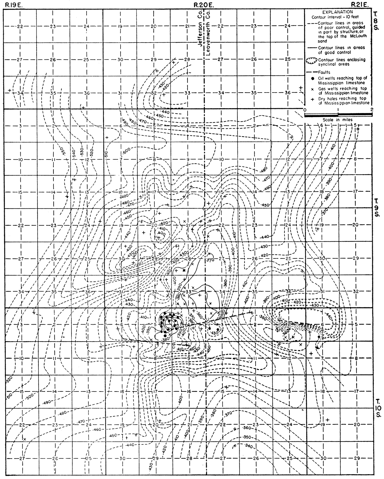
Figures 6, 7, 8, and 9 show the structure at the top of the Oread limestone, base of the Hertha limestone, top of the McLouth sandstone, and top of the Mississippian limestone. The structure at the top of the Warsaw limestone (fig. 10) and at the top of the porous dolomite zone-of the undivided Burlington and Keokuk limestones (fig. 11) is shown only in the McLouth pool because not enough wells have penetrated these datum beds to determine the detailed structure in a larger area. These maps were drawn from data determined by microscopic examination of complete sets of well samples and of insoluble residues below the Pennsylvanian rocks. In all, 202 sets of samples, which are now on file at the State Geological Survey, were collected and studied. Table 27 gives a list of all the wells completed in and adjacent to the field to June 15, 1943, and the depths and altitudes of the datum points used in drawing the structure maps.
Figure 6—Map showing the structure of the McLouth field contoured on the top of the Oread limestone. The structural relief is slightly greater than that on rocks exposed at the surface.

Figure 7—Map showing the structure of the McLouth field contoured on the base of the Hertha limestone. The contours show structural relief greater than that on the top of the Oread limestone.
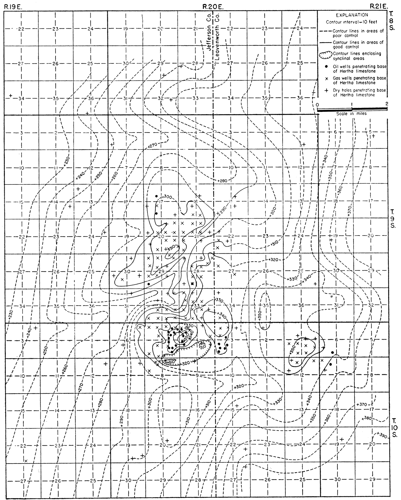
Figure 8—Map showing the structure of the McLouth field contoured on the top of the McLouth sand. The contours show structural relief markedly greater than that on the base of the Hertha limestone.
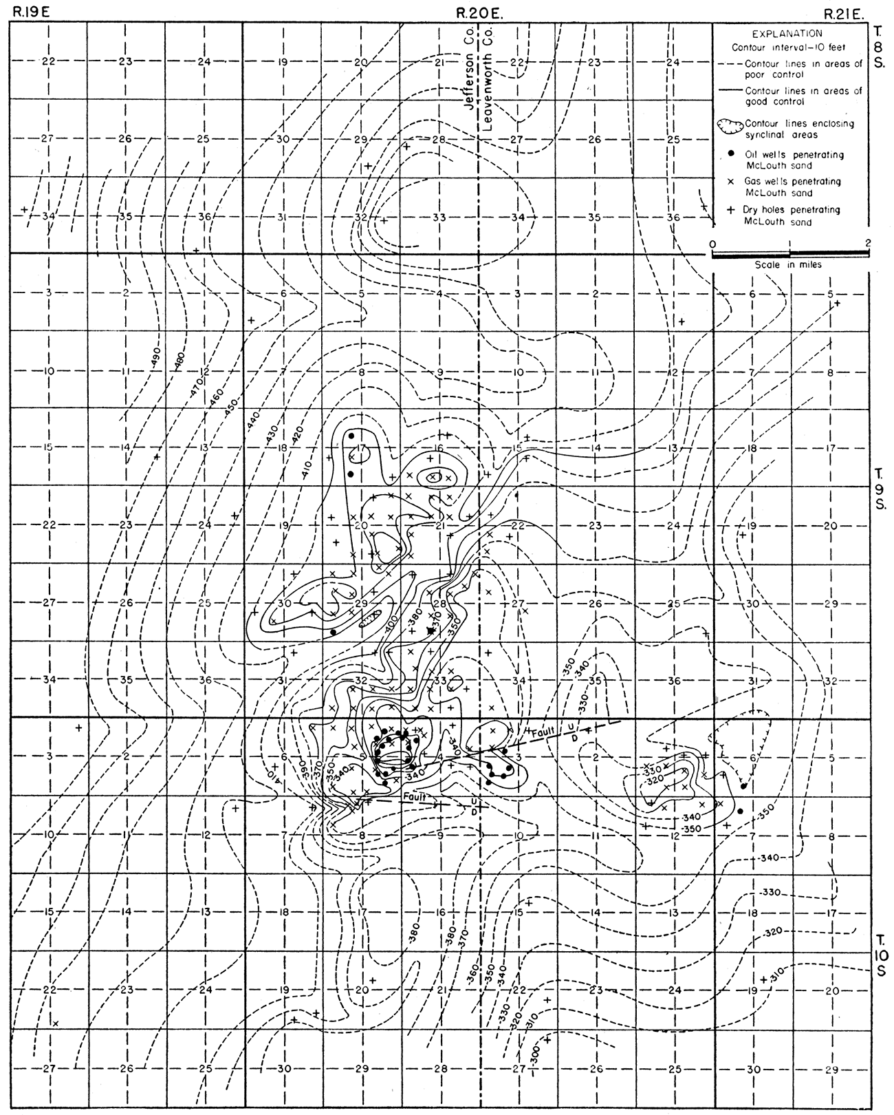
Figure 9—Map showing the structure of the McLouth field contoured on the top of the Mississippian limestone. The structural expression on the top of the Mississippian limestone is distinctly greater than that on the top of the McLouth sand, but is modified by mild pre-Pennsylvanian erosion.
This series of structure maps shows that the amount of folding increases with depth at least to the upper Mississippian rocks and that the folds were initiated in pre-Pennsylvanian time. Conversely, the maps show that during deposition of the Pennsylvanian rocks the folds were continually being revived by small increments of deformation. The vague amoeba-like pattern of the structure of the surface rocks represents only the distortion caused by structural movements that took place after the deposition of the Lecompton limestone.
Only six wells in the McLouth field have been drilled to the Devonian rocks, so the local structure of the pre-Mississippian rocks cannot now be determined. It is believed from the general relations that all the folds in the McLouth field originated after Mississippian time and will be found not to increase in intensity below the Mississippian. An angular unconformity separates the Devonian and older rocks from the Mississippian, however, and, although the amount of deformation of individual anticlines in the older rocks is the same as in the Mississippian, the expression of folding, as shown by the structural maps, may be modified below the angular unconformity by the pre-Mississippian regional dip toward the northwest.
Increase of Closure with Depth
The present closure of the anticline of the McLouth pool is less than 20 feet at the surface on the Lecompton limestone, but increases to 25 feet on the Oread limestone and to more than 30 feet on the base of the Hertha limestone. The closure on the top of the McLouth sand is more than 60 feet. The structural relief of the pre-Pennsylvanian rocks is even greater than on the McLouth sand (figs. 10, 11, and 13), and it is evident that well-defined structure was developed in the Mississippian rocks before the peneplanation that preceded Pennsylvanian deposition.
In the North McLouth pool no closure is shown in the surface rocks, but there are some areas with local closure of less than 10 feet at the top of the Oread limestone. The closure is more than 20 feet on the Hertha limestone and more than 30 feet on the top of the McLouth sand. The structural relief also increases in the Mississippian rocks on this anticline, but structural details on the crest are lacking. The Ackerland pool has a closure of about 20 feet in the surface rocks but the closure, as revealed by drilling, is at least 40 feet at the top of the McLouth sand.
Figure 10—Map showing structure of the McLouth pool contoured on the top of the Warsaw limestone. The structural. relief is greater than that on the McLouth sand.
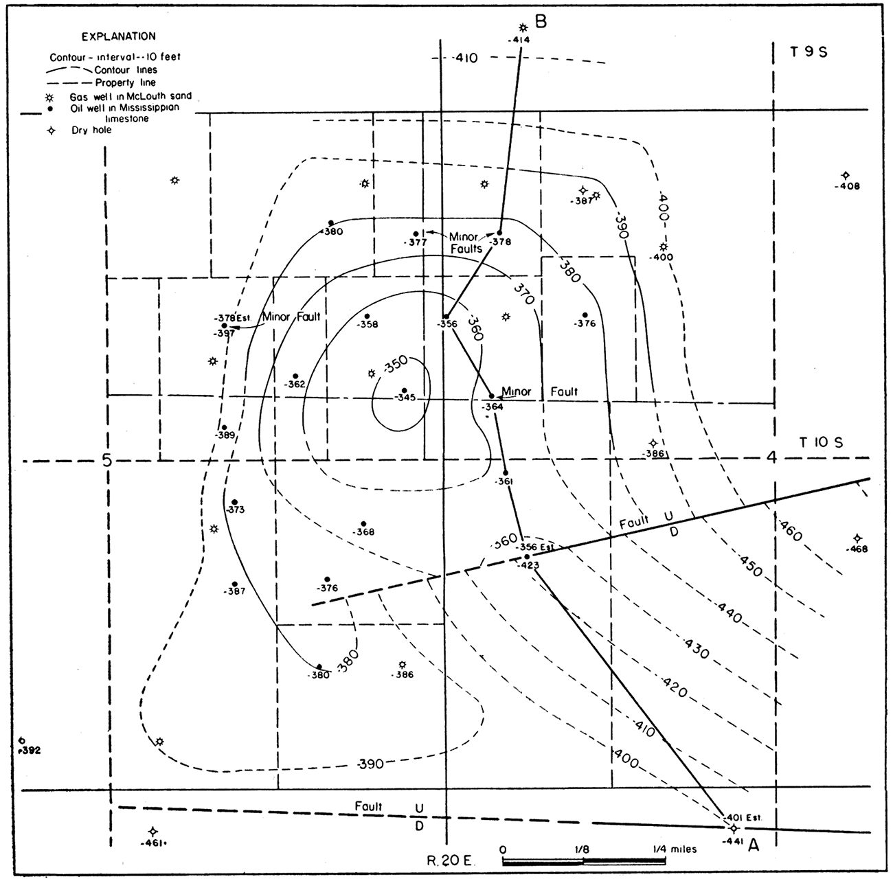
Figure 11—Map showing structure of the McLouth pool on the top of the productive dolomite zone of the undifferentiated Burlington and Keokuk limestones. The structural relief differs from that at the top of the Warsaw because several wells reveal shortened intervals of 12 to 17 feet between the Warsaw limestone and the dolomite zone. These shortened intervals are believed to represent minor tension faults in the Mississippian, but neither the strike nor the direction of displacements is known.
Relation of Surface Structure to Production
It will be noted in plate 2 that the distribution of gas and oil wells is not very closely related to the anticlinal areas of the surface structures. On the west side of the McLouth pool, gas wells have been drilled in a wide area outside the area of closure of the surface rocks. The discovery well of the field was located on the crest of the anticline as indicated by the surface rocks. Later drilling showed that the crest in the surface rocks was nearly one-half mile from the crest in the Mississippian rocks. The surface crest is outside the area of Mississippian oil production on the crest of the subsurface anticline. The area from which gas is produced in the North McLouth pool shows no closure in the surface rocks, but only a structural nose. The McLouth sand in the subsurface shows well-defined anticlinal structure. Comparison of the structure of the surface rocks with the structure of the subsurface rocks thus reveals a shift both in the position of the crests of the anticlines and also in the areas of closure.
Effect of Regional Dip on the Expression of Structure by Contour Lines
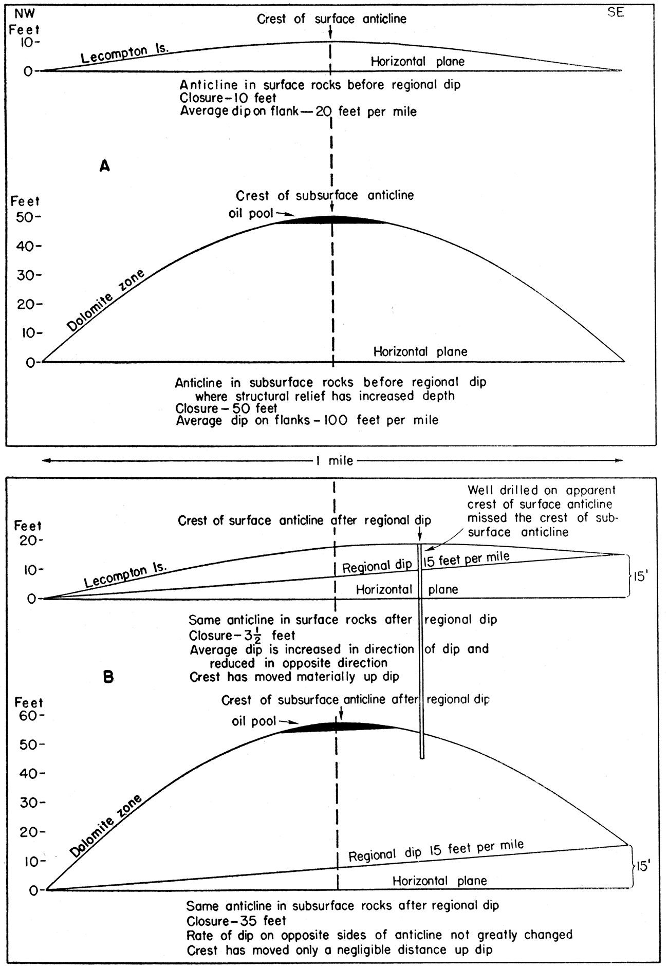
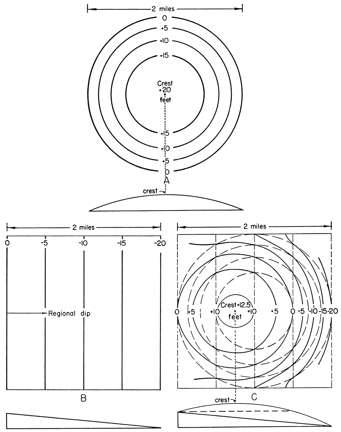
In order to explain the above-described anomalies it is necessary to consider the effect of regional dip upon the expression of structural features of varying degrees of relief. The effect of regional dip upon previously developed anticlines is shown diagrammatically in figure 12 by cross sections in the direction of the dip. Cross section A represents a low anticline in the surface rocks. The subsurface rocks are represented as having been more sharply deformed than the surface rocks, as is the case in the McLouth field. Cross section B shows the effect of regional dip on the surface and subsurface anticlines. It will be noted that the regional dip has not appreciably changed the position of the subsurface anticline and that the reverse dip has been reduced by the amount of regional dip. The regional dip, however, has produced a marked shift in the position of the crest of the low surface anticline and has reduced its closure by the amount of regional dip. The reverse dip of both surface and subsurface anticlines has been reduced by the same amount, but in the surface rocks the regional dip has almost eliminated the closure. A lower reverse dip at the surface or a steeper regional dip would destroy the closure and reduce the crest of the surface anticline to a structural bench.
Figure 12—Cross-sectional diagrams with exaggerated vertical scale to show: (A) relation of surface and subsurface anticlines in regionally horizontal rocks where structural relief increases with depth, and (B) altered relations of surface and subsurface anticlines and shift in position of crest of surface anticline after development of regional dip.
The effect of regional dip on a low hypothetical dome represented by contour lines is shown in figure 13. The regional dip (B) imposed on the dome (A) has caused the crest of the dome to shift up dip, has reduced the closure of the dome, and has altered the configuration of the contour lines as shown in figure 13 (C). The same regional dip on deeper and consequently steeper structures reduces the amount of closure by the amount of regional dip but only slightly modifies the configuration of the contour lines. The shift in the position of the subsurface crest is negligible.
Figure 13—Sketches to scale showing effect of regional dip on hypothetical dome with low relief. A, Symmetrical dome with closure of 20 feet and average dips of 20 feet per mile. B, Regional dip of 10 feet per mile. C, Effect of regional dip imposed on dome. Dotted lines show original dome; full lines show result of tilting. Crest has moved one-fourth mile up dip and closure is reduced from 20 to 12 1/2 feet, Contour interval, 5 feet in all sketches.
The regional dip thus induces a discrepancy between the position of the crest in low surface. anticlines and its position in steeper anticlines of deeper rocks. It should be noted that the amount of deformation of the strata in relation to a plane surface has not been altered, but that it is the expression of the dome by means of contour lines that has been altered as a result of the changed relation of the structure to the horizontal plane.
The extraordinary effect that the regional dip may have under certain conditions in shifting the crest of low surface anticlines is shown in a paper dealing with another subject by Rich (1935, pp. 1540-1543). Illustrations for this article, partly reproduced in figure 18, show the structure of an area in Greenwood county in T. 23 S., R. 9 E. as indicated by the surface structure and as it appears with the regional dip eliminated. The crest of the principal anticline shown in this township has been shifted southeast from its original position in sec. 9 to sec. 27, a distance of nearly 3 miles. If structural relief in Greenwood county increases in depth in the same ratio as in the McLouth field, the crest of the anticline in the deeper rocks will be found 3 miles distant from its position as mapped on the surface rocks rather than beneath the crest of the surface anticline.
The imposition of regional dip on pre-existing structure involves the greatest change in the expression of structure by contour lines in the surface rocks where the reverse dips are low. Where the sharpness of structure increases in depth, the contours on the deeper rocks, although they receive the same amount of regional dip, suffer less distortion (fig. 12).
The steeper the structural slopes and the sharper the anticline, the less the crest is shifted by regional dip. The crests of anticlines with reverse gradients commensurate with the subsequently imposed regional dip always undergo an important shift in position unless the crests of the folds are narrow and paralleled the strike of the dipping rocks. In this connection, it is pertinent to point out that the bottom of the Forest City basin was shifted at least 15 miles by the regional dip (fig. 4 and pl. 1).
Alteration of Contour Lines in the McLouth Field by Regional Dip
In order to determine the effect of regional dip on the structure of the McLouth field, the surface structure, as mapped by Haworth and Taylor, was recontoured to eliminate regional dip. The method used is described by Rich (1935, pp. 1538-1540) and illustrated in figure 13. The original position of the dome in A may be restored from C by considering C hinged on the zero-contour line of the regional dip and swinging the dip surface upward to a horizontal position. Corrections are made on the contour lines of the dome according to the amount of movement. No corrections are made on the hingeline. Elevations of points at the intersection of structure contours of the dome with contours of the regional dip are then made. The elevations at intersections of contours of the dome with 5-foot contours of the regional dip are increased 5 feet, those on the 10-foot contour are increased 10 feet, and so on. Restoration of the elevation of points on the dome between the contours may be determined by making similar but intermediate corrections.
The red lines of plate 2 determined in this manner represent the present surface structure of the McLouth field before development of regional dip. The actual local deformation of the strata has not changed but the contours, after regional tilting, have a different expression with respect to sea level. The regional dip in the McLouth field is about 15 feet per mile N. 700 W. in the surface rocks in the McLouth field. The dip was determined by averaging the dip across the field between wells far enough apart to eliminate the effect of local structure. The direction of strike was determined from the geological map of Kansas.
The surface structure of the McLouth field prior to the development of regional dip as represented by the red lines of plate 2 included many elements with lower or only slightly greater gradients than the regional dip. The regional dip caused a considerable shift in the position of the crest of the McLouth anticline and decreased the area of closure. The North McLouth anticline had original reverse surface dips so low that the regional dip reduced the fold in the surface rocks to a structural nose. The surface closure of the Ackerland anticline, only part of which has been tested at this date (April 1, 1943), was greatly restricted by the regional dip.
It has been pointed out that the area yielding gas in the McLouth pool (pl. 2, black lines) is eccentric to the present area of closure of the tilted surface beds and that gas wells on the west side extend far outside the closing contour. In plate 2 (red lines) which shows surface structure corrected for regional dip, all the gas wells lie within the area of closure represented by the 1,125-foot contour line of the structure in its original attitude. This line corresponds closely in position to the -375-foot contour of the structure on the McLouth sand (fig. 8). The original area of closure of the surface rocks and the distribution of gas thus correspond closely to the structural expression at the top of the McLouth sand (fig. 8) but differ sharply from the uncorrected surface structure with the imposed regional dip. Had this relation been recognized during the early development of the field, the extension of the producing area beyond the area of surface closure might have been anticipated.
The surface structure of the North McLouth pool, centering in secs. 20 and 21, T. 9 S., R. 20 E., is merely a broad anticlinal nose trending northwest without closure in the surface rocks. The restoration of this surface structure to its original horizontal position as shown in plate 2 (red lines) reveals an original low anticline. All but three of the gas wells lie within the 1,130-foot contour of the restored structure map. This line corresponds closely to the -395-foot contour of the McLouth sand. The lack of complete agreement is due in part to imperfections of mapping where there were no outcrops and in part to the fact that there was some deformation of the sand reservoir after accumulation of the gas. This factor will be discussed later. It should be pointed out, however, that where there is poor control for mapping the surface structure the corrected lines also will lack accuracy. This difficulty is illustrated on the west side of the North McLouth anticline where control for mapping the surface beds was inadequate.
The Ackerland pool, in sec. 1, T. 10 S., R. 20 E., lies on the eastern end of a surface anticline that has a closure of about 20 feet. The surface structure of this anticline seems to be well authenticated by numerous outcrops. Correction for regional dip in this area greatly enlarges the area of closure which may have two crests. Only the eastern end of this anticline has been tested at this date (April 1, 1943). The restored contours in the Ackerland pool reflect the subsurface structure of the McLouth sand, so far as developed, more accurately than the unrestored surface structure.
The importance of determining the original attitude of the structure is well illustrated in the McLouth pool by the Mississippian dolomite. The crest of the dome that yields oil from the Mississippian dolomite was shifted so far from the subsurface crest that the well drilled on the surface crest lay outside of, and missed, the producing area (pl. 2). If the well drilled on the apparent crest had been the only test drilled to the Mississippian, it would probably have been concluded that the Mississippian rocks were unproductive.
The crests and areas of closure of structures in the subsurface and the areas of production of oil and gas are thus in close agreement with the original surface structure as revealed by the elimination of regional dip. They do not agree with the surface structure as contoured in their present relation to sea level. Weak surface structures recontoured with elimination of regional dip are, therefore, a more trustworthy guide to the development of weak surface structures than is their present attitude. Where anticlines are strongly developed in the surface rocks and trend in the direction of regional strike, as in central Kansas, these considerations are of no importance; however, under conditions prevailing in northeastern Kansas, they have an important bearing on the localization of producing areas.
In view of the structural relations existing at McLouth, no structural features in northeastern Kansas expressed in the surface rocks by low gradients, irrespective of the actual amount of closure, should be condemned or drilled until they have been evaluated by restoring the contour lines to their originally horizontal attitude.
Faulting in the McLouth Field
Faulting has been determined in the Mississippian rocks in two wells south of the McLouth field. It does not seem to be very strongly developed in the lower Pennsylvanian, either because of declining activity or because faults tend to die out in the incompetent shales of the Pennsylvanian. The Young and Longwell No. 1 McLeod well, in NW SW sec. 4, T. 10 S., R. 20 E., drilled through a fault having a displacement of 62 feet in the Mississippian. This fault was recognized by the fact that the interval from the top of the Warsaw limestone to the top of the dolomite zone was 62 feet less than the normal interval in other wells of the field. A normal or tension fault is indicated by the shortening of the interval between the datum beds. The downward displacement of the rocks on the south side is shown by the structural relations of nearby wells; the strike is shown by the attitude of the Mississippian limestone and the McLouth sand in wells in the S2 sec. 4, T. 10 S., R. 20 E. The fault seems to die out in the SE of sec. 5, but may extend toward the east into the NW of sec. 2.
Another normal fault that caused a shortened interval in the Mississippian rocks was revealed by the Apperson No. 1 McLeod (Hunter) well, in the NE NE NW sec. 9, T. 10 S., R. 20 E. The downward displacement caused by this fault is 45 feet. The control, however, is at present inadequate to determine with confidence the strike and direction of displacement although the fault is shown tentatively on the maps (figs. 9, 10, 11) as trending slightly north of west with a downward displacement on the south. Several other wells on the McLouth anticline have shown shortened intervals in the Mississippian rocks. The Sherrod No. 2 Bower well, an irregularly-spaced well in the NE SW NE sec. 5, T. 10 S., R. 20 E., found the interval between the top of the Warsaw and the top of the Burlington-Keokuk dolomite zone 17 feet shorter than normal. This shortened interval is believed to indicate a minor fault, but the strike and direction of displacement are uncertain. Some other shortened intervals that suggest minor faults in the Mississippian have been noted in other wells, but they may be the result merely of inaccurate measurements of depth or the result of depth corrections which have not been reported in the logs. One shortened interval in the Lansing group that has, however, been doubtfully accepted because of the location of the well occurs in the McNerney No. 1 Fidler well, in the NE NW sec. 2, T. 10 S., R. 20 E. In this well the Lansing group is 15 feet thinner than in the nearest wells. This well lies on the trend of the northeastern extension of the Young-McLeod fault. The possibility exists that the shortened interval may be the result of a correction of depth not reported in the log.
Interpretation of Structure from the Thickness Map of the McLouth Sand
Some of the displacements along the faults seem to have occurred prior to peneplanation of the Mississippian but were not subsequently revived in earliest Cherokee time. These conclusions are reached by a study of the thickness of the McLouth sand as shown in figure 14. The relief of the Mississippian surface at the end of McLouth deposition is indicated roughly by the thickness contours from the top of the McLouth sand to the top of the Mississippian limestone. The close parallelism of the top of the McLouth sand and the thin white siltstone, 20 feet higher, indicates that the top of the McLouth sand was essentially a flat surface when it was deposited. There has probably been slightly greater compaction of the sand and shale below the top of the McLouth in areas where the deposits of shale and sandstone were thick and less where these deposits were thin. The relief of the pre-Pennsylvanian surface referred to the top of the sand as shown by the thickness map (fig. 14) is probably slightly less than the actual relief when the McLouth was deposited by the difference in the amount of compaction that occurred over -elevations and over depressions. The original relief, however, was essentially as shown on the thickness map. The thinnest deposits of McLouth sand on the McLouth anticline as shown by the isopachous lines follow the structural trend of the McLouth sand (pl. 2, red lines) northward from sec. 4, T. 10 S., R. 20 E. into sec. 22, T. 9 S., R. 20 E., and conform in a general way to the anticlinal trend of this pool in spite of the fact that parts of the Mississippian surface in sec. 5, T. 10 S., R. 20 E. and sec. 32, T. 9 S., R. 20 E. were obviously channeled. Similarly, the McLouth sand is thin over the anticline of the North McLouth pool and the thickness lines of the sand roughly conform to the structural pattern of that anticline (pl. 2, red lines). In the Ackerland pool, thin McLouth deposits overlie the crest of the dome. The deep narrow syncline between the McLouth and North McLouth pools is also clearly recognizable in the thickening of the McLouth deposits in that area.
The Mississippian rocks exposed in pre-Pennsylvanian time at the surface of the McLouth and North McLouth anticlines were entirely Spergen dolomite—a homogeneous, sparsely cherty, silty dolomite without contrasting hard and soft beds—unlikely to produce a topographic hill on the crest of an arch as a result of selective erosion. The thinning of the McLouth sand on the anticlines is thus due to the revival of the earlier fold and reveals one of the increments of the slowly developing structure which continued active at least through Lecompton time.
The intermittent development of some of the faults in the McLouth field is indicated at several points. The increase in the thickness of the McLouth interval on the down-throw side of the fault in the Young and Longwell No. 1 McLeod well from 30 feet north of the fault to 45 feet on the south, and to 75 and 89 feet in wells in the N2 SE sec. 4, has already been mentioned in the chapter on thickness of the McLouth sand. This fault shows a displacement of 62 feet in the Young and Longwell No. 1 McLeod well, of which at least 34 feet took place prior to the deposition of the Pennsylvanian. It may have continued active even to Hertha time, as suggested in figure 15, but there is no indication of displacement in the upper part of the Pennsylvanian.
The Sherrod No. 1 Benne well in the NW NW NE sec. 8, T. 10 S., R. 20 E., shows an abrupt increase in the McLouth interval from 49 feet in an offset well to 94 feet in the Benne welt Even greater displacement occurs in the Mississippian rocks of this well. The structural displacement was not materially, if at all, revived during later Pennsylvanian time. In the Apperson No. 1 McLeod (Hunter) well, in the NE NE NW sec. 9, T. 10 S., R. 20 E., the McLouth sand zone has an average thickness of 39 feet on the downthrow side of the fault. Therefore, the displacement of 44 feet noted in the Mississippian rocks took place prior to peneplanation and was not revived appreciably during Cherokee time.
The abrupt increase in the thickness of the McLouth sand in the three dry wells in the N2 sec. 1, T. 10 S., R. 20 E. on the north side of the Ackerland pool is interpreted as indicating a fault Chert fragments in shale in the McLouth sand 35 to 45 feet above its base in two of three wells north of the displacement suggest proximity to an escarpment of Mississippian rocks. This sharp fault or monocline was, however, not revived in the younger Pennsylvanian rocks, and the structure, as contoured on the Hertha, Oread, and Lecompton limestones, fails to give any indication of more recent displacement.
Known and suspected faults in the McLouth field have a general trend east and northeast. They do not seem to be parallel to each other but converge upon each other at sharp angles between northeast and east.
Prev Page—Producing Zones || Next Page—McLouth Sand
Kansas Geological Survey
Comments to webadmin@kgs.ku.edu
Web version July 2019. Original publication date June 1944.
URL=http://www.kgs.ku.edu/Publications/Bulletins/53/05_stru.html