![]()
Prev Page--Mississippian Series || Next Page--Osage
Mississippian Series, continued
Rocks of Kinderhook or Osage Age
A sequence of strata in the subsurface of Kansas here tentatively designated the Gilmore City and the Sedalia limestones, is not now definitely referable to either the Kinderhook series or the Osage series. In north-central Iowa, where the Gilmore City is exposed, it is underlain by the Hampton formation of Laudon in which he includes as its basal member the Wassonville limestone, the correlative of the Sedalia limestone of northeastern Missouri. The areas in Iowa in which the Mississippian is exposed are continuous with the Mississippian exposures of Missouri only in a narrow belt along Mississippi river in southeastern Iowa and northeastern Missouri. In this connecting belt the Gilmore City limestone and all but the basal member of the Hampton are absent. In consequence the determination of the relations of the formations in Iowa to those in Missouri is dependent on paleontological criteria. L. R. Laudon, who has studied the Gilmore City and Hampton in greatest detail, believes that both these formations are of Kinderhook age but are younger than the Chouteau; on the other hand, R. C. Moore classifies the lowest member of the Hampton (the Wassonville) or the equivalent Sedalia as of Fern Glen age and the upper part as of Burlington age; and on the basis of Federal Geological Survey unpublished data, J. S. Williams also regards the Wassonville and Sedalia of northeast Missouri as of Osage age. Thus, according to the interpretation of Moore and Williams, the Hampton and Gilmore City cannot be of Kinderhook age, On account of these differences of opinion it seems desirable to discuss the Gilmore City and Sedalia, tentatively identified in the subsurface in Kansas, as rocks of Kinderhook or Osage age.
Table 2, showing the sequence of geologic units for north-central Iowa and southeastern Iowa, is presented for the better understanding of the discussion to follow.
Table 2--Showing correlation of Kinderhook and associated formations in north-central and southeastern Iowa.
| North-Central Iowa L. R. Loudona |
North-Central Iowa R. C. Moorec |
Southeastern Iowa L. R. Loudonb |
Southeastern Iowa R. C. Moorec |
|---|---|---|---|
| Mississippian Meramec series St. Louis ls. |
Mississippian Meramec series Pella beds (Ste. Genevieve) St. Louis Alden ls. |
Mississippian Pella beds St. Louis ls. Spergen ls. Warsaw ls. Keokuk ls. Burlington ls. |
Mississippian Meramec series Pella beds St. Louis ls. Salem ls. |
| Kinderhook series Gilmore City ls.d Hampton fm. Iowa Falls ls. Eagle City ls. Maynes Creek ls. Upper Chapin ls. Lower Chapin ls. (Chouteau) |
Osage series Burlington ls. Iowa Falls ls. Eagle City ls. Fern Glen ls. Maynes Creek ls. (Sedalia) |
Kinderhook series Hampton fm. Wassonville ls. North Hill ls.(Chouteau) English River ss. Maple Mill sh. Sweetland Crk. sh. |
Osage series Warsaw ls. Keokuk ls. Burlington ls. Fern Glen ls. Wassonville ls. (Sedalia) |
| Kinderhook series Chapin ls.(Chouteau) Sheffield sh. |
Kinderhook series North Hill ls. (Chouteau) English River ss. Maple Mill sh. Sweetland Crk. sh |
||
| a. Laudon, L. E., Stratigraphy and paleontology of the Gilmore City formation of Iowa: Iowa Univ. Studies in Natural History, vol. 15, No. 2, 1933, and Supplemental statement on the Mississippian system in Iowa: Guidebook, Ninth Annual Field Conference, Kansas Geol. Soc., p. 246, 1935. b. Laudon, L. R., Stratigraphy of the Kinderhook series of Iowa: Iowa Geol, Survey. vol. 35, pp. 353 and 348, 1931, and Supplemental statement on the Mississippian system in Iowa: Guidebook, Ninth Annual Field Conference, Kansas Geol. Soc., p. 246, 1935. c. Moore, R. C., The Mississippian system in the upper Mississippi valley region: Guidebook, Ninth Annual Field Conference, Kansas Geol. Soc., pp. 2~O-245, 1935. d. Laudon correlates the Gilmore City limestone with the Alden limestone in north-central Iowa, but not with the Spergen (Salem) limestone of southeastern Iowa. Moore correlates the Alden with the Spergen (Salem). |
|||
Moore and Laudon agree that the North Hill limestone of southeastern Iowa and the lower Chapin of north-central Iowa are correlatives of the Chouteau of Missouri. They also agree that the Sedalia or Upper Chouteau of some geologists is properly correlated with the Wassonville of southeastern Iowa and is at least in part equivalent to Laudon's Upper Chapin and Maynes Creek of north-central Iowa. Moore, however, from faunal evidence, concluded that the Sedalia limestone, equivalent to the Wassonville of Laudon, is of Fern Glen age. Laudon, on the contrary, also on faunal evidence, has concluded that not only the Wassonville and Maynes Creek members of his Hampton formation are of Kinderhook age, but also places in the Kinderhook his overlying Eagle City and Iowa Falls limestone members of the Hampton as well as the still younger Gilmore City limestone. Whatever the age that may ultimately be assigned to these formations, distinct lithological units, corresponding to the outcropping rocks, occur in the subsurface above rocks of Chouteau age. These units will be discussed tentatively by the names of the surface formations that they are believed to represent.
Sedalia Limestone
General statement
The term Sedalia limestone was introduced by Moore (1928, p. 149) for the slightly siliceous dolomite that was originally called Upper Chouteau by Swallow in 1855. This dolomite is still regarded as a member of the Chouteau by some geologists. It comes to the surface on the northern flank of the Ozarks where it extends from north-central Missouri to western Illinois. Moore (1928, p. 22; 1935, pp. 242, 245) correlated it with the Wassonville limestone in exposures at Burlington in southeastern Iowa.
Outcrops
In its typical outcrops in north-central Missouri, the Sedalia is a massively bedded dolomite weathering to smooth, rounded surfaces. It is somewhat siliceous in some places. Dense, dark chert in discontinuous nodules and interrupted thin bands is mentioned by Moore as a local constituent. In most outcrops it is chiefly composed of sucrose buff or brown dolomite. Its maximum thickness in north-central Missouri is 40 feet.
Subsurface character in Kansas
Down dip from the outcrops in Saline county, Missouri, the Missouri Geological Survey has identified the Sedalia limestone in the cuttings of some wells in northwestern Missouri. In the Kasper-James well (sec. 8, T. 13 S., R. 25 E.) in Johnson county, Kansas, samples of 30 feet of coarsely sucrose buff and gray dolomite overlying typical Chouteau rocks were identified as Sedalia by the Missouri Geological Survey at a depth of 1,060 to 1,090 feet below the surface. In other parts of northeastern Kansas, cuttings similar to those in the Kasper-James well are found in the samples overlying the Chouteau. These cuttings are generally buff and brown, moderately fine sucrose dolomite. They contain only small amounts of chert or other insoluble residue, but generally include some chert carried down from overlying limestones during drilling operations. That part of the residue that is characteristic of the Sedalia consists of microscopically botryoidal aggregations of roundish granules of chert, which seem to be the result of siliceous growth around impurities. Some of these aggregations are crumbly, but where the granules are more nearly completely merged, gray or buff rough grainy masses of chert similar to the chert in the underlying Chouteau are formed. Some of the Sedalia cherty residues show rhombohedral casts of dolomite crystals that were removed from the siliceous cement by acid treatment.
Distribution and thickness
The rocks referred to as Sedalia have been recognized in Kansas only in the northeastern part of the state in the area shown in plate 8. In the Kasper-James well (cross sections C-C' and D-C', pl. 6) in Johnson county, the Sedalia is 30 feet thick, and in Douglas and Wabaunsee counties about 20 feet thick. It is thinner west of the Nemaha ridge, where it overlaps upon the Chattanooga shale (cross section D-C', pl. 6). In Saline and Douglas counties its thickness is only about 10 feet and farther northwest it is thinner or absent.
In central Linn county (well No. 6, cross section C-C'. pl. 6) it is only 13 feet thick and in Allen county, wells No. 5 and No. 4 show, respectively, thicknesses of 10 and 6 feet. In northwestern Allen county (Oklahoma Natural Gasoline Company No. 1 Union Central Life Insurance Company well, sec. 28, T. 23 S., R. 18 E.), the Sedalia is 18 feet thick and overlies the coarsely silty phase of tile Northview. Dolomite of similar character, though thin, occurs locally above the Northview even farther south in Crawford county (Kansas City Southern No. 1 Pittsburg well, sec. 20, T. 30 S., R, 25 E.), and in Wilson county (Union Gas Corporation No. 5 Mary Watt well, sec. 34, T. 28 S., R. 17 E., well No. 3 of cross section C-C', pl. 6), where the writer believes the dolomite to represent the Sedalia. In the Wilson county well it underlies typical St. Joe limestone. An isolated area of thin dolomite (see pl. 8), which the writer believes to be an outlier of the Sedalia, occurs in southeastern McPherson county (Ts. 20 and 21 S., Rs. 2 and 3 W., well No. 15, cross section A-A', pl. 5) between Chattanooga shale and beds assigned to the Gilmore City. Another possible outlier represented by 5 feet of dolomite below the St. Joe was observed in a single well in Harvey county (sec. 23, T. 23 S., R. 2 W., well No. 13, cross section A-A', pl. 5).
Stratigraphic relations
The buff and brown dolomite referred to the Sedalia occurs nearly everywhere above the Chouteau limestone in the outcrops, from northeastern Missouri to northeastern Kansas, except where younger rocks are unconformable above the Chouteau. As shown in cross section D-C', plate 6, the Sedalia continues beyond the area of the Chouteau and overlaps upon the Chattanooga whose reddened upper surface seems to have been the result of weathering before the deposition of the dolomite. Laudon (1931, pp. 37S-379), in his work on the Kinderhook in Iowa, reports that northward from Burlington, Iowa, the Wassonville (correlative of the Sedalia) similarly overlaps progressively beyond the North Hill (correlative of the Chouteau) upon English River, Maple Mill, and Sheffield formations in southeastern Iowa. Moore (1928, pp. 72-73, 150) noted that in northeastern Missouri the Sedalia rests in some places upon Devonian and older rocks. This relation and the similar relation in Kansas also probably represents overlap.
In Allen and Wilson counties the brown dolomite, discussed as Sedalia, overlies Northview shale, which, as previously stated, is the approximate equivalent of the upper part of the Chouteau. Farther south and west in Kansas the Sedalia is absent. East of the Nemaha ridge where the Sedalia is absent, its position at the top of the Northview is occupied by rocks identified as St. Joe limestone.
In Wabaunsee county, in parts of Lyon and Jackson counties, and very generally west of the Nemaha ridge, the Sedalia is overlain by a group of limestones tentatively correlated with the Gilmore City of Iowa. In other localities of northeastern Kansas, as in the outcrops in Missouri, the Sedalia is unconformably overlain by Burlington limestone. In southeastern Kansas it is overlain in many places by rocks of late Fern Glen age.
The Sedalia of northern Kansas is a thin formation, but the Hampton formation of Laudon in Iowa, which he believes includes as its basal member the Wassonville (equivalent to the Sedalia)· has been found by Laudon (1933, p. 19) to increase in the subsurface of Iowa to 180 feet near Webster City in Hamilton county. In the published composite columnar section for Iowa, Laudon gives the Hampton a thickness of 250 feet. These figures, however, include the North Hill or Lower Chapin limestones, which were subsequently correlated with the Chouteau and separated from the Hampton by Laudon (1935, p. 246).
The Sedalia seems to be conformable above the Chouteau, because the Sedalia is a thin formation throughout northern Missouri and Kansas and accompanies the Chouteau from Illinois to northwestern Kansas and overlaps upon other rocks beyond the Chouteau margin. Swartzlow (1933, p. 273), who treated the Sedalia as the upper member of the Chouteau, described the contact of the Chouteau and Se-' dalia as transitional in character and therefore one of conformity.
If the Sedalia is of Kinderhook age, a hiatus, represented by the absence of rocks of upper Hampton age, Gilmore City limestone, and Fern Glen limestones occurs where Burlington rocks are in contact with the Sedalia. The Gilmore City is reported by Laudon to be unconformable upon his Hampton formation in Iowa, but where the Gilmore City limestone overlies the Sedalia in Kansas the thickness of the Sedalia has such slight variations that there is little to suggest a hiatus. If an unconformity exists between these formations, the erosion of the surface of the Sedalia in Kansas must either have approached peneplanation locally before the Sedalia was covered by the Gilmore City or the surface remained so near sea level that only thin Hampton deposit sediments represented by the Sedalia were laid down in Kansas.
The Sedalia was identified in the cuttings of the Kasper-James well (sec. 8, T. 13 S., R. 25 E.) in Johnson county by the Missouri Geological Survey and was correlated by the writer with a similar lithologic unit in other wells in eastern Kansas. The fact that the Sedalia is thin, is consistently present above the Chouteau throughout a large area without irregular thinning, and is overlain in some places by rocks assigned to the Gilmore City formation suggests that the Sedalia is more closely allied to the Chouteau than to the overlying rocks of Osage age.
The age of this dolomite zone cannot be determined with confidence from the well cuttings because of the difference of opinion in regard to the age in outcrops. If the Gilmore City is of Kinderhook age the underlying dolomite must also be of Kinderhook age. If the formations overlying the Hampton in Iowa are of Osage age, the dolomite may be of Osage age.
Gilmore City Limestone
General statement
The name Gilmore City was given by Laudon (1933) to a group of limestones in central Iowa. These limestones had previously been regarded in some localities as a part of the St. Louis limestone and in others assigned to the Kinderhook under the names Humboldt oolite and Alden limestone. The formation, as already mentioned, is placed in the upper Kinderhook on faunal grounds by Laudon (1933; 1935, p. 246), but some paleontologists place the formation in the Osage series.
Surface outcrops
The outcrops of the Gilmore City in north-central Iowa are covered by glacial drift in most localities and the formation has only a small surface exposure. As described by Laudon, the Gilmore City at the outcrops is essentially a pure white or gray oolitic limestone. It is "usually bedded with green shale"; and minor amounts of blue dolomite occur at definite horizons. The formation is, however, not oolitic throughout and many beds are only sparsely oolitic. No single exposure shows both the top and bottom of the formation. The maximum exposed thickness is 57 feet at Gilmore City, Pocohantas county, Iowa, on Des Moines river where the formation is overlain by the St. Louis limestone. At Alden, in Hardin county, Iowa, on Iowa river it is 32 feet thick and rests unconformably upon the Iowa Falls, the youngest member of the Hampton formation, of which the Wassonville of southeastern Iowa, correlative of the Sedalia limestone of that area, is believed by Laudon to be the base.
Subsurface distribution in Iowa
Laudon found it possible to trace the Gilmore City limestone in well logs in western and southwestern Iowa by its distinctive lithologic characteristics and prepared a thickness map of the formation for that state (Laudon, 1933, p. 18). The thickest areas of the Gilmore City in Iowa lie north and northeast of Omaha, Neb. If the basin, contoured by Laudon, were extended toward the southwest, its deepest part indicated by the thickness lines would extend across Nebraska and enter Kansas near the center of the northern border of Kansas. If projected across the region of the central Kansas uplift, the deep part of the basin would extend into the western part. of Kansas. Northeastern Kansas and northwestern Missouri lie on the southeastern flank of the basin as thus projected. McQueen and Greene (1938, p. 33) have noted limestones in wells in northwestern Missouri similar to those described by Laudon and have tentatively correlated them with the Gilmore City limestone. These limestones are reported to be 74 feet thick in the well-known Forest City well (sec. 4, T. 59 N., R. 38 W., Holt county, Missouri) across Missouri river from the northeastern corner of Kansas.
Subsurface development in Kansas
Rocks tentatively correlated with the Gilmore City limestone are found in the subsurface in Kansas in two areas. One of these is northeast of the central Kansas uplift and the other in western Kansas, southwest of that uplift.
In Smith, Osborne, Mitchell, western Dickinson, and northern Saline counties in Kansas, the brown dolomite correlated with the Sedalia limestone is overlain by clean noncherty or very slightly cherty limestone composed of fragments of broken shells and crinoids. The limestone is semigranular and, ordinarily, slightly buff gray or yellowish gray. Some beds contain fine-textured dark or black limestone pellets. The matrix that cements the crystallized fossiliferous granules is soft, opaque, and milky white. Owing to the softness of the limestone, the cuttings recovered in drilling are generally small. Fragments of green shale form a minor constituent of some samples.
The limestone in many places includes some oolitic beds, which, although irregular in horizontal and vertical distribution, are most commonly 25 to 35 feet above the base. The oolites, mostly gray, together with fragments of fossils, are cemented in a soft limy matrix. They are irregularly sized and many of them are slightly irregular in form. Where the black limestone pellets are present some of the oolites have black centers. Some of the broken oolites show alternating light and slightly darker gray bands.
The siliceous residues of samples from the Gilmore City limestone are very small and include cherty tailings from the overlying rocks and some translucent chert that may be indigenous. The characteristic residue includes fine quartz crystals in loose aggregates and thin finely drusy crusts. In Saline county and the counties to the north and northwest these crystalline assemblages and the associated semitranslucent chert are lemon yellow, both in beds that contain oolites and in the semigranular limestones that do not. In McPherson county and east of the Nemaha ridge, this fine drusy material is composed of clear quartz crystals, but otherwise the siliceous residues are similar. Pale-buff or gray, opaque, microscopically mamillary and columnar crusts of chalcedony are sparsely present with the drusy aggregates. Silicified shells of oolites though unusual are an occasional constituent in residues from the oolitic beds.
Where thin sections of Gilmore City overlap upon the Chattanooga shale in McPherson county and in areas east of the Nemaha ridge the oolites, which occur higher in the section, are generally not present, and the formation thus resembles the St. Joe limestone of earliest Fern Glen age. The Gilmore City is distinguishable, however, by its buff-gray color, and the soft opaque character of its matrix, and by the fine quartz aggregations and mamillary and columnar crusts of opaque chalcedony in the small insoluble residues.
In western Kansas in Logan, Scott, and Finney counties and in Yuma county, Colorado, similar gray, faintly yellow, and buff-gray limestones. are widely present beneath the Burlington. The limestone is semigranular. The crystalline granules in many beds are composed largely of finely broken shell fragments cemented with a soft opaque gray limestone matrix. Many zones superficially seemm to be oolitic, but perfectly rounded oolites are not common. The grains are subangular, elongated, and irregularly shaped particles with algal crusts, most of which are considerably thicker than the crusts common to oolites. The centers include fragments of shells, minute crinoid joints, and crystallized calcite. In some beds, near the base, the gray limestone crusts enclose irregular fragments of fine-textured dark-gray to black limestone, thus producing crusted granules, which, except for shape, are like the dark-centered oolites in northeastern Kansas. The siliceous residues of these rocks in the Watchorn and McNeely No. 1 Spangler well (sec. 23, T. 20 S., R. 33 W., Scott county, well No. 3, cross section F-F', pl. 7) are small and contain the same kind of yellowish loose drusy aggregates that characterize the rocks tentatively correlated with the Gilmore City east of the central Kansas uplift.
Thickness
As may be seen from the cross sections and figure 3, the general thickness of the Gilmore City in northwestern Kansas is 20 to 35 feet. Its maximum known thickness is 52 feet in southeastern Mitchell county (Gurley No. 1 Abercrombie well, sec. 32, 1'. 9 S., R. 7 W.), but farther northwest (in well No. 2, cross section D-C', pl. 6, where part of the samples are missing) in south-central Jewell county it may reach a thickness of 76 feet.
Figure 3--Sketch map showing distribution and thickness of Gilmore City limestone in Iowa, after Laudon, with additions for Kansas. Contour interval, 50 feet. [A larger Acrobat PDF version of this figure is available.]
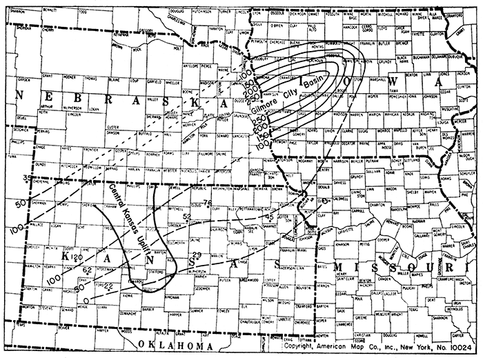
In western Kansas the greatest observed thickness of the Gilmore City beds is in Scott county (Watchorn and McNeeley-Spangler well), where it is 120 feet thick In the Alma No. 1 McNeeley well (sec. 13, T. 15 S., R. 33 W., well No. 2, cross section F-F', pl. 7) in Logan county it is 115 feet thick. From this well northwestward the thickness decreases to 35 feet in Yuma county, Colorado (I. T. I. O. No. 1 Strangways well, sec. 21, T. 2 S., R. 43 W., well No. 1, cross section F-F', pl. 7). The thickness of the Gilmore City decreases southeastward from the Spangler well. In the National Refining Company No. 1 Wells well (sec. 13, T. 23 S., R. 30 W., well No. 4, cross section F-F', pl. 7) of Finney county the thickness is 68 feet and it seems to be only 22 feet in the Swain No. 1 Taylor well (sec. 21, T. 25 S., R. 24 W., well No. 5, cross section F-F', pl. 7), in northern Ford county.
Distribution
In Kansas, east of the central Kansas uplift, the Gilmore City is present as far south as McPherson county (see pl. 8). Its southeastern margin trends approximately northeast through central Lyon county and north of Douglas county. The presence of 74 feet of limestone tentatively correlated with the Gilmore City in the Forest City well turns the 50-foot thickness line eastward from Jackson county, Kansas, where 45 feet is present (Haverbach et al, No. 1 Uhl well, sec. 26, T. 9 S., R. 14 E., well No. 16, cross section B-B', pl. 5) farther south than was indicated by the Iowa data used by Laudon. Some thin outliers of the same limestone formation without oolites may be present even as far south as Harvey county.
The limits of the Gilmore City in southwestern Kansas are less sharply outlined because fewer wells have been drilled in that area. The formation seems to be absent in southeastern Ford county and tD the southeast. It probably is thin from pre-Pennsylvanian erosion on the flank of the central Kansas uplift. If, as seems possible, it was deposited across the uplift it was removed during one of several periods of exposure that occurred during and at the close of Mississippian time.
Stratigraphic relations
At the outcrops in north-central Iowa, the Gilmore City is reported by Laudon (1933) to rest unconformably on the Iowa Falls limestone, the uppermost member of his Hampton formation (see table 2). Near Webster City, Hamilton county, Iowa, the Hampton formation, which in Laudon's (1933, p. 19) report includes correlatives of the Chouteau of Missouri, is 180 feet thick. The Hampton decreases in thickness toward the south and west. At Bedford in Taylor county, in southwestern Iowa, near the Missouri line, the Gilmore City is reported to be in contact with the Chattanooga shale, and at Glenwood, Mills county, Iowa, south of Omaha, Neb., the pre-Gilmore City limestones are reported to be absent. The Hampton therefore is missing in considerable areas in southwestern Iowa and the area of its distribution is bounded by an irregular pattern, which excludes parts of southwestern Iowa and northwestern Missouri.
In northeastern Kansas the oolitic limestones correlated with the Gilmore City are chiefly in contact with the Sedalia, but in McPherson county similar but nonodlitic limestone overlies the Chattanooga. In Cloud county, Kansas (Concordia Oil Company No. 1 Murdock well, sec. 6, T. 6 S., R. 4 W.), oolitic Gilmore City rocks extend beyond the Sedalia and overlie red shale at the top of the Chattanooga similar to that present beneath the Sedalia in many wells in this part of Kansas. In western Kansas the Gilmore City overlies pre-Chattanooga rocks.
The relation of the Gilmore City to the Sedalia presents an appearance of conformity in the Kansas cross sections A-A', plate 5, and D-C', plate 6, but in view of the widespread unconformity at the base of the Gilmore City in Iowa and the absence of rocks of Hampton age younger than the Sedalia in northeastern Kansas, it is probable that there is also an unconformity between the Gilmore City and the Sedalia in Kansas.
The Hampton formation of Laudon may have had originally a much wider distribution and the even surface that the Sedalia (correlative of the basal Hampton) presents to the Gilmore City in northeastern Kansas may be the result of erosion that in this area left only the basal part of the formation.
The St. Louis limestone of Meramec age unconformably overlies the Gilmore City limestone at the type locality and in the subsurface in west-central Iowa. In southwestern Iowa, however, the Gilmore City is reported by Laudon (1933, p. 18) to be overlain by Osage cherty limestones, reported to be 200 feet thick at Council Bluffs and as much as 300 feet thick in Taylor county near the Missouri state line.
In Kansas the Gilmore City strata are in most areas overlain by rocks of Burlington age.· In McPherson county they are overlain by rocks of Fern Glen age. (See cross section A-A' of pl. 5.) The upper surface of the Gilmore City is not so smooth and regular in northeastern Kansas as its lower contact with the underlying Sedalia for small local fluctuations in the thickness of the Gilmore City are noticeable. The most striking of these occurs in Jackson county. The Gilmore City limestone in the Haverbach et al. No. 1 Uhl well (sec. 26, T. 9 S., R. 14 E., well No. 16, cross section B-B', pl. 5) has a thickness of 40 feet, the lower 20 feet of which is oolitic. Eleven miles to the north, in Goens No. 1 Wabaunsee well (sec. 3, T. 8 S., R. 14 E., well No. 17, cross section B-B', pl. 5) the Gilmore City and Sedalia are both absent and the Burlington rocks are in contact with the Chouteau. Six miles northeast of this well the Chouteau in Garvin No. 1 Lutz well (sec. 27, T. 7 S., R. 15 E., well No. 18, cross section B-B', pl. 5) is overlain by 15 feet of Gilmore City, the Sedalia possibly being represented in 15 feet of missing samples. It seems probable, therefore, that, although Gilmore City deposition may have centered in the Kinderhook basin of Iowa, the limestone may once have had a greater thickness and a more widespread distribution than at present and that it was reduced in thickness by erosion before being covered by the overlapping Osage and Meramec rocks. The Gilmore City basin, as outlined, has a trend that does not conform to any of the structural trends of this part of the Mississippi basin. As reported by Laudon the Gilmore City limestones are thick where they overlie the Chattanooga shale and thin where they overlie the Chouteau or Hampton rocks. These relations suggest that the Gilmore City limestone was deposited in an erosional basin.
Prev Page--Mississippian Series || Next Page--Osage
Kansas Geological Survey, Geology
Placed on web Jan. 27, 2013; originally published Sept. 1, 1940.
Comments to webadmin@kgs.ku.edu
The URL for this page is http://www.kgs.ku.edu/Publications/Bulletins/33/04_kind.html