![]()
Prev Page--Subdivisions--Leonardian || Next Page--Inferred History
Major Subdivisions, continued
Guadalupian
Lithostratigraphic Units
This interval is subdivided into three formations, in ascending order, the Whitehorse Formation (figs. 14, 65), Day Creek Dolomite (fig. 66), and Big Basin Formation (fig. 67). From bottom to top the members of the Whitehorse are the Marlow Sandstone, Relay Creek (?) dolomite, an unnamed member, and the Kiger shale (fig. 2). Of these three formations, the Whitehorse is the thickest with the Marlow sandstone and the unnamed member accounting for most of its 82.3-m (270-ft) thickness (Zeller, 1968, p. 52).
Formations
Whitehorse Formation--At the outcrop, the Whitehorse is a very fine grained red sandstone and siltstone with some mudrock and dolomite (Swineford, 1955, p. 92; fig. 65). The two intervals of this formation that contain beds of dolomite are the thin Relay Creek (?) dolomite and Kiger shale members. Maher (1946, p. 2; 1947, p. 3) indicated that the Whitehorse is mostly red mudrock to sandy red mudrock with some red sandstone and thin beds of dolomite in the subsurface. Newell (1940, p. 272, fig. 2) identified marine fossils from the "Whitehorse Springs lens," near the base, and the "Woodward lens," near the top of the Whitehorse Formation from exposures in southern Kansas and northern Oklahoma. In both units the bivalve Dozierella is present, indicating a Guadalupian age (Newell, 1940, p. 280-281).
Figure 65--Exposure of the Whitehorse Formation on the south side of US-160 where it crosses Keiger Creek; near center of north line, sec. 10, T. 33 S., R. 24 W., Clark County, Kansas.
Day Creek Dolomite--Although the Day Creek Dolomite is thin, 0.6-0.9 m (2-3 ft) at the outcrop (Zeller, 1968, p. 53), Swineford (1955, p. 92) reported a thickness of 36.6 m (120 ft) in the subsurface. At the surface this formation is a fine-grained, dense dolomite with some chert nodules associated with red silty mudrocks. In the subsurface, anhydrite and red mudrocks are conspicuous, and where the Day Creek is thickest, it is mostly anhydrite (Mudge, 1967, p. 115; fig. 66).
Figure 66--Day Creek Dolomite in the Red Hills, Clark County, Kansas; from photo files of the Kansas Geological Survey.
Big Basin Formation--The uppermost Permian unit in Kansas is the Big Basin Formation, named for Big Basin, a depression in Clark County. Lithologically, it is similar to the other Permian red-bed units of Kansas-red silty mudrocks and fine-grained red silty sandstones with some anhydrite and dolomite (fig. 67). According to Zeller (1968, p. 53), the thickness is a maximum of 13.7 m (45 ft) at the outcrop, but Merriam (1963, p. 81) reported a thickness of 91.4 m (300 ft) in the subsurface.
Figure 67--Big Basin Formation at Big Basin, looking east-southeast from US-160 and 283 from the NW corner sec. 25, T. 32 S., R. 25 W., toward the center sec. 25, T. 32 S., R. 25 W., Clark County, Kansas.
Upper Boundary of the Guadalupian
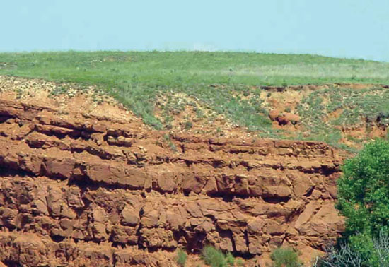
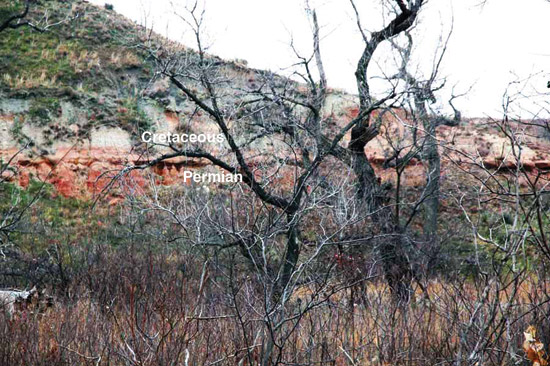
The top of the Permian in Kansas is an erosional unconformity; the Guadalupian Big Basin Formation marks the top of the Permian (Ochoan rocks are probably missing). Zeller (1968) judged the overlying rocks to be Jurassic in age, cropping out at only one locality (Morton County) and occurring in the subsurface in northwestern Kansas (see Zeller, 1968, p. 53, fig. 9). East of the Jurassic pinchout, the Permian is overlain by rocks of Cretaceous (figs. 68, 69) and Neogene age. The outcrop in Morton County was previously classified as Triassic Dockum Group, and a figure in MacLachlan (1972, p. 172, fig. 6) suggested the same.
Figure 68--View looking west at the Cretaceous-Permian contact from the road on the east side of Clark State Fishing Lake; taken from near center of E/2 sec. 36, T. 30 S., R. 23 W., Clark County, Kansas. The dark-reddish rocks in the lower third of the photo are Permian and the lighter-colored rocks above are Cretaceous.
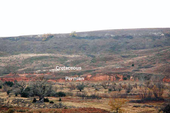
Figure 69--Close-up of the Cretaceous-Permian contact below the dam at Clark State Fishing Lake in the SW sec. 36, T. 30 S., R. 23 W., Clark County, Kansas; red rocks are Permian and lighter-colored rocks are Cretaceous.
Lithofacies and Thickness of the Guadalupian
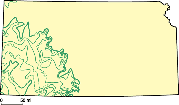
Red siliciclastics with associated evaporites and dolomite are the dominant lithology of the Guadalupian sequence in Kansas. The lithologies are very similar to the underlying Leonardian except that salt, so prominent in the Leonardian, is absent. Present-day thickness of the Guadalupian rocks in Kansas (fig. 70; see Mudge, 1967, p. 108, fig. 36) is the result of post-Permian erosion with rocks of either Jurassic or Cretaceous age directly overlying the Permian in Kansas (Mudge, 1967, p. 121, fig. 42).
Figure 70--Isopach map of Guadalupian rocks in Kansas; contour interval = 100 ft, poor control where dashed (modified from Mudge, 1967, fig. 36, p. 108).
Depositional Environments and Source Areas of the Guadalupian
Subsequent erosion makes it difficult to comment accurately on the source of and environment within which the Guadalupian rocks were deposited. Using lithologic features and the thin fossiliferous beds of the Whitehorse Formation, it is reasonable to suggest that conditions were not very different from those that prevailed during the Leonardian: coastal to continental environments associated with restricted marine basins. In addressing this issue, Swineford (1955, p. 166) stated, "An influx of fine feldspathic sand, perhaps both from the west and south, produced the Whitehorse formation (sic). The supply of medium-grained clastic material gradually diminished during Whitehorse time, montmorillonite (bentonitic?) clays were deposited, as was also a thin persistent dolomite (Day Creek). The poorly sorted sands and silts of the Taloga formation [today's Big Basin Formation] suggest the incidence of slight instability, and perhaps the deposition of poorly reworked flood-plain debris before the Permian seas withdrew entirely from the area."
The Guadalupian sequence in Kansas, like the underlying Leonardian, is also an appropriate interval for detailed studies within the conceptual framework of sequence stratigraphy and other modern techniques. As noted by Miller and West (1998) relative to paleosol sequences in the Wolfcampian, it will be difficult to recognize and document those events that are essential to this approach. However, careful stratigraphic documentation can only improve our understanding of this unique time during Kansas history.
Prev Page--Subdivisions--Leonardian || Next Page--Inferred History
Kansas Geological Survey, Geology
Placed on web April 27, 2010; originally published April 2010.
Comments to webadmin@kgs.ku.edu
The URL for this page is http://www.kgs.ku.edu/Publications/Bulletins/257/05_subd_3.html