![]()
Prev Page--Permian Rocks || Next Page--Subdivisions--Leonardian
Major Subdivisions
Introduction
Currently the Kansas Geological Survey subdivides the Permian into three series, the Wolfcampian, Leonardian, and Guadalupian; the Ochoan Series is probably not present in Kansas (Zeller, 1968; Sawin et al., 2008; see also fig. 2). This subdivision is similar to that used by McKee and Oriel (1967) and Mudge (1967), who designated the Wolfcampian as Interval A, the Leonardian as Interval B, and the Guadalupian as Interval C. The base of the Permian, Wolfcampian (Interval A) in these two 1967 publications, was placed at the base of the Towle Shale Member of the Onaga Formation as it was in Zeller (1968). Today the base of the Permian is placed at the base of the Bennett Shale Member of the Red Eagle Limestone (Sawin et al., 2006). Thus, the interval from the base of the Onaga Formation to the base of the Bennett Shale Member is now considered part of the upper Carboniferous, Pennsylvanian Subsystem. This should be kept in mind when the Wolfcampian in these two 1967 publications is referred to in this document.
Using the accepted stratigraphic terminology of the Kansas Geological Survey (Zeller, 1968; Sawin et al., 2008), the Wolfcampian includes, in ascending order, the upper part of the Council Grove Group and the Chase Group. This is compatible with the internationally accepted Carboniferous-Permian boundary (Boardman et al., 1998, Sawin et al., 2006; Sawin et al., 2008).
The internationally recognized Carboniferous-Permian boundary at the base of the Bennett Shale Member of the Red Eagle Limestone results in the lower part of the Council Grove Group being Carboniferous and the upper part being Permian (Sawin et al., 2008, p. 2). Wahlman (1998, 2007) referred to the upper Carboniferous part of the Council Grove Group as the lower Council Grove Group. Currently the Kansas Geological Survey (Zeller, 1968; Sawin et al., 2008) considers the base of the Americus Limestone Member of the Foraker Limestone as the base of the Council Grove Group.
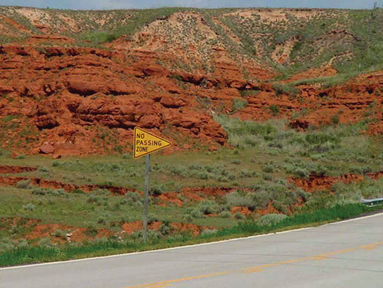
Wolfcampian rocks include the rock sequence from the base of the Bennett Shale Member to the top of the Herington Limestone Member. The Leonardian includes the interval from the base of the Wellington Formation to the top of the Dog Creek Formation. Rocks from the base of the Whitehorse Formation to the unconformity at the top of the Big Basin Formation constitute the Guadalupian. Outcrop exposures of strata from these three intervals are shown in the following figures: Wolfcampian (figs. 10, 11), Leonardian (figs. 12, 13, 14), and Guadalupian (fig. 15).
Figure 10--Rocks of the Council Grove Group (Neva limestone through Speiser Shale) exposed on the east face of Tuttle Creek Lake Spillway; near the center of SW sec. 18, T. 9 S., R. 8 E., Pottawatomie County, Kansas.
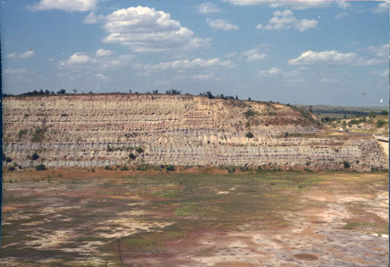
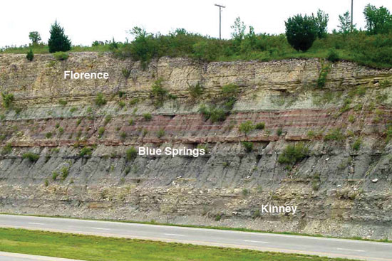
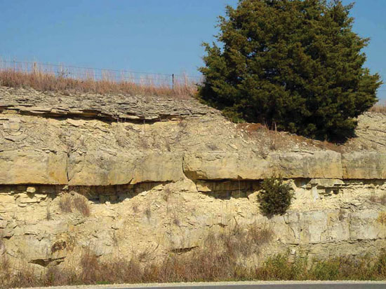
Figure 11--Exposure of the Florence Limestone Member and Blue Springs Shale Member along the east side of K-177 just north of the Riley-Geary county line; just south of the center of the west line, sec. 20, T. 11 S., R. 8 E., Riley County, Kansas.
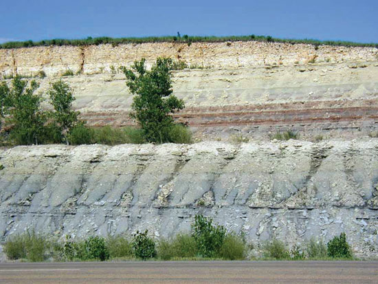
Figure 12--Exposure of the Flower-pot Shale on the south side of US-160; NE NE sec. 12, T. 32 S., R. 14 W., Barber County, Kansas.
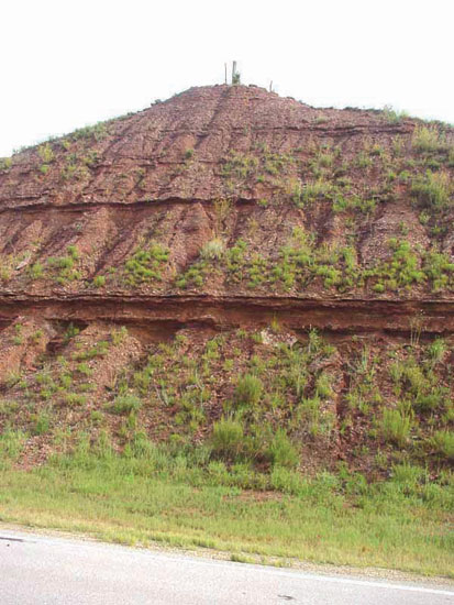
Figure 13--Exposures of the Cedar Hills Sandstone along Gyp Hill Road looking southwest; near center of N/2 sec. 20, T. 32 S., R. 12 W., Barber County, Kansas.
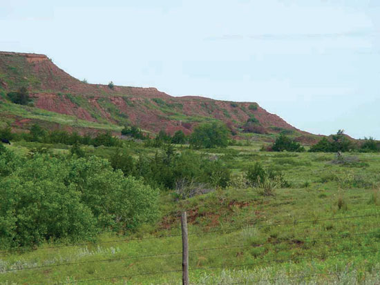
Figure 14--Exposure of the Dog Creek Formation near the type area along north side of US-160; near center of north line sec. 9, T. 32 S., R. 14 W., Barber County, Kansas.
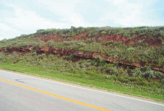
Figure 15--Exposure of the Whitehorse Formation on the north side of US-160 where it crosses Keiger Creek; near center of south line, sec. 3, T. 33 S., R. 24 W., Clark County, Kansas.
Wolfcampian
Lithostratigraphic Units
The lithostratigraphic nomenclature for the lower Permian of Kansas has undergone nearly as much revision and redefinition as the Carboniferous-Permian boundary itself (see Chaplin [1988] for a summary of the evolution of this nomenclature). Prosser (1895, 1902) was the first to establish 2. However, nomenclatural problems in the lower Permian sequence remain as pointed out by Chaplin (1988), who listed the following: 1) lack of designated type sections for over half of the proposed stratigraphic units; 2) lack of adequate geologic descriptions for some type sections; 3) type sections now poorly exposed or inaccessible; 4) type sections difficult if not impossible to locate due to use of ephemeral geographic markers; 5) designation of more than one type section with different facies; and 6) designation of widely separated type localities for groups (formations) and their component formations (members). These problems become especially acute when trying to correlate these units into southern Kansas and Oklahoma.
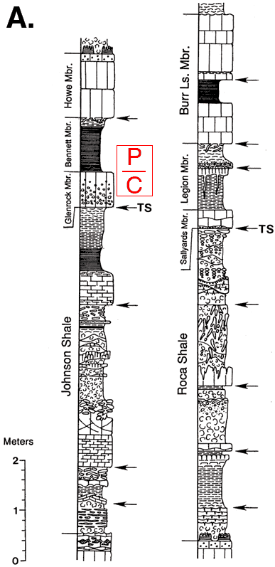
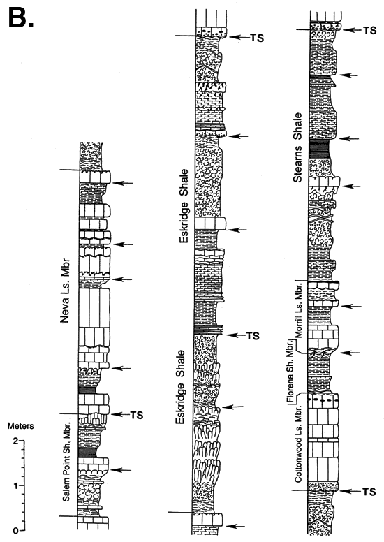
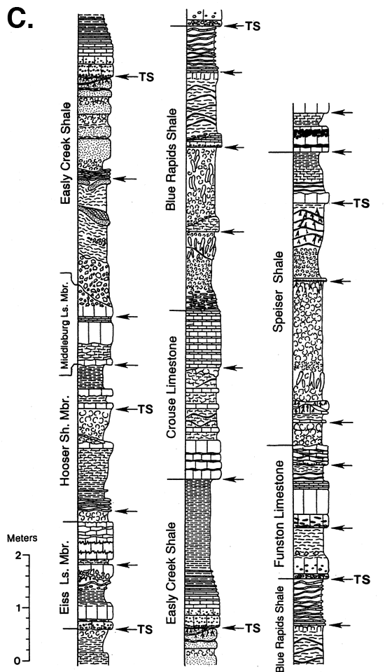
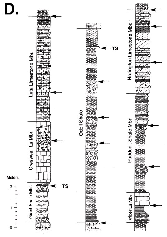
Figures 16A, B, C--Detailed stratigraphic column of the Council Grove Group in north-central Kansas showing flooding and transgressive surfaces. Arrows mark flooding surfaces that bound meter-scale parasequences and TS marks transgressive surfaces that mark cyclothem boundaries. 16A, Johnson Shale through Burr Limestone Member from sec. 18, T. 9 S., R. 8 E., Pottawatomie County, Kansas (modified from Miller, 1994; West, 1994). 16B, Salem Point Shale Member through Neva Limestone Member of Grenola Limestone from sec. 23, T. 10 S., R. 7 E., Riley County Kansas; Eskridge Shale through Stearns Shale from sec. 10, T. 10 S., R. 7 E., Riley County, Kansas. 16C, Eiss Limestone Member of Bader Limestone through Speiser Shale from sec. 21, T. 10 S., R. 7 E., Riley County, Kansas (modified from Miller and West, 1993). See also Archer et al., 1995.
Council Grove Group
Excellent summaries and outcrop descriptions of the stratigraphy of the Council Grove Group are given in Mudge and Yochelson (1962) and Mudge and Burton (1959). We will not repeat this information, but rather will give general descriptions and present new observations made since the publication of these important field studies. A detailed stratigraphic column of the Council Grove Group in northeast Kansas is shown in figs. 16A, B, C. These figures provide a reference for the following unit descriptions. As discussed earlier, the recently established stratigraphic position of the Carboniferous/Permian boundary is at the base of the Bennett Shale Member within the Red Eagle Limestone of the Council Grove Group (figs. 3, 4). It is not only a now well-established biostratigraphic boundary, but also a rather abrupt change in the lithologic character of cyclothemic deposition (West et al., 1997). Although the Council Grove Group, as currently defined, contains Pennsylvanian units (Foraker Limestone, Johnson Shale, and the Glenrock Limestone Member of the Red Eagle Limestone), our discussion will begin with the Red Eagle Limestone, the formation containing the Carboniferous (Virgilian)-Permian (Wolfcampian) boundary. Because of the biostratigraphic importance of this formation, our discussion is rather detailed.
Red Eagle Limestone--Over much of its Kansas outcrop, the Red Eagle Limestone consists of two limestone units separated by a dark-gray to black shale and varies from 3 m (10 ft) to as much as 10.7 m (35 ft) in thickness (O'Conner and Jewett, 1952; Sawin et al., 2006). These members are, in ascending order, the Glenrock limestone, the Bennett shale, and the Howe limestone. O'Conner and Jewett (1952) and McCrone (1963) studied, in detail, the lithology and paleontology of the Red Eagle Limestone from southern Nebraska to Oklahoma.
The Glenrock limestone is a medium- to light-brownish-gray fusulinid-bearing limestone with algal-coated grains common locally. It has a remarkably uniform thickness of 0.3-0.6 m (1-2 ft) in outcrop north of the Bourbon arch in east-central Kansas. Southward the Glenrock thins to less than 0.15 m (0.5 ft) and cannot be recognized in southernmost Kansas and Oklahoma (McCrone, 1963, p. 23), and the Bennett shale becomes a limestone with several thin shale beds at the base and shale partings in the middle and upper part (O'Connor and Jewett, 1952). O'Connor and Jewett (1952) based their recognition of the Bennett on the Orbiculoidea assemblage that is characteristic of the Bennett and can be traced from Oklahoma to Nebraska (McCrone, 1963; Sawin et al., 2006). At Manhattan and Paxico, on either side of the Nemaha anticline, the Glenrock is conglomeratic with abundant granule- to pebble-sized clasts of micrite (McCrone, 1963; Miller, 1994). Between these localities, the Glenrock is missing and the Bennett shale rests on the underlying Johnson Shale formation.
As noted in figs. 16A, B, C, some of the recognized genetic surfaces correspond to the lithostratigraphic contacts between the members of the Red Eagle Limestone. The base of the Glenrock limestone is identified as a transgressive surface and the base of the Howe limestone as a flooding surface. There is some evidence that the top of the Glenrock limestone, the Carboniferous-Permian boundary, is an omission surface (Boardman et al., 1998). This is also true for some of the other lithostratigraphic units in figs. 16A, B, C. Olszewski and Patzkowsky (2003) also indicated the close association between some genetic surfaces and the boundaries of lithostratigraphic units. Thus, the genetic surfaces appear to be much more consistent than the units themselves (Olszewski, personal communication, 2006).
In the northern part of the outcrop belt, the Bennett shale is mainly a calcareous medium-gray laminated shale with a thin dark-gray to black fissile shale at its base (McCrone, 1963). The conodont assemblage in the lowermost mudrocks of the Bennett shale is currently recognized as Permian in age and conodonts from the underlying Glenrock limestone are considered Carboniferous (Boardman et al., 1998). Orbiculoid brachiopods occur throughout the member but are especially abundant in the dark, fissile basal shale. Skeletal remains of fish also occur in the Bennett shale. Part of a eugeneodontid elasmobranch from an exposure of the Bennett shale in the Tuttle Creek Lake Spillway, an exposure that resulted from the 1993 flood, was described by Schultze and West (1996). The Bennett decreases from 2.4 to 1.2 m (8-4 ft) in thickness southward toward Manhattan, and then becomes thicker and increasingly calcareous toward Eskridge. From Eskridge to Council Grove, just north of the Bourbon arch, the facies changes abruptly into a medium-bedded limestone up to 9.1 m (30 ft) thick with brachiopods, crinoids, bryozoans, and fusulinids (McCrone, 1963). It then thins again over the Bourbon arch and becomes shaly. This locally thick facies was identified as a bioherm (O'Connor and Jewett, 1952) and as a biostrome (Mudge and Burton, 1959), but the buildup is not substantially different from other correlative limestone facies in the Bennett (McCrone, 1963). In southern Kansas and into Oklahoma, the Bennett thickens again and changes into a limestone 3-4.6 m (10-15 ft) thick that comprises most of the Red Eagle Limestone. The continued presence of orbiculids at the base has been used in its correlation. However, tracing genetic surfaces (Olszewski and Patzkowsky, 2003) indicates that the limestones are not facies equivalents of the shales.
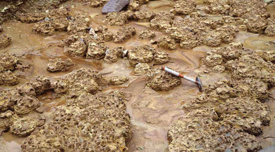
The Howe limestone, a massive limestone 0.6-1.5 m (2-5 ft) thick, is readily recognized throughout the Kansas outcrop belt (fig. 17). In Nebraska and northern Kansas, it is a fine-grained light-gray vesicular limestone, and in central and southern Kansas it is a fossiliferous grainstone characterized by gastropods, ostracodes, fusulinids, arenaceous forams, coated fossil grains, and ooids. McCrone (1963) described the grain coatings as being algal in origin and referred to the grainstones as "osagites," but more recent work indicates that they are ooids with continuous, concentric laminae (Shapiro and West, 1999). O'Connor and Jewett (1952), McCrone (1963), and Elick (1994) described stromatolites capping the Howe in central Kansas (fig. 18). Shapiro and West (1999) described these domical stromatolites, which vary in shape and microstructure between localities, as dominated by cornuspirid gastropods and calcifying filamentous algae.
Figure 17--Exposure of the Howe Limestone Member with the Bennett Shale Member below, looking north from the eroded area below the Tuttle Creek Lake Spillway; near center of N/2 sec. 19, T. 9 S., R. 8 E., Pottawatomie County, Kansas.
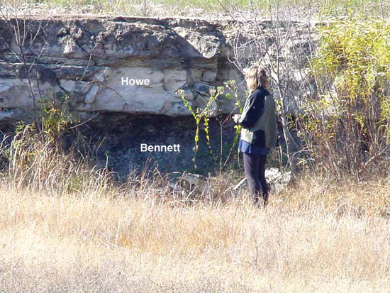
Figure 18--Algal stromatolites at the top of the Howe Limestone Member in the eroded exposure below the Tuttle Creek Lake Spillway; near center N/2 sec. 19, T. 9 S., R. 8 E., Pottawatomie County, Kansas.
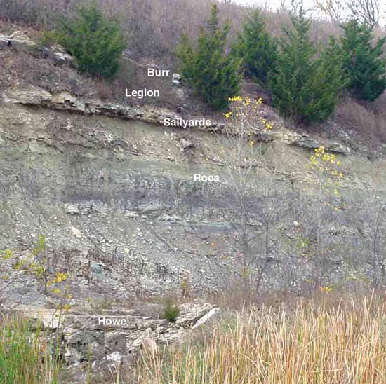
Roca Shale--The Roca Shale is predominantly a reddish-brown to light-greenish-gray calcareous mudrock 4.3-5.5 m (14-18 ft) thick in exposures across Kansas (fig. 19). The Roca consists of several mudrock intervals separated by thin micritic limestones with finely fragmented fossil debris (Miller, 1994).
Figure 19--Exposure of Roca Shale and Grenola Limestone on the west side of the eroded area below Tuttle Creek Lake Spillway; near center N/2 sec. 19, T. 9 S., R. 8 E., Pottawatomie County, Kansas.
All these mudrocks contain evidence of subaerial exposure, and well-developed paleosol profiles occur in most of them. In Riley County, the paleosols show a consistent vertical pattern from salt-influenced natric paleosols at the base, to reddish calcic paleosols, to greenish-gray vertic paleosols at the top (Miller et al., 1996; McCahon and Miller, 1997; Rankey and Farr, 1997). A relatively well preserved fossil-plant assemblage has been described from the upper Roca in Wabaunsee County (Warren, 1969).
Grenola Limestone--Above the Roca are the alternating lithologies of the Grenola Limestone. The five members of this formation are, in ascending order, Sallyards limestone, Legion shale, Burr limestone, Salem Point shale, and Neva limestone (figs. 19, 20).
Figure 20--Exposure of Grenola Limestone, Eskridge Shale, and Cottonwood Limestone Member of the Beattie Limestone along the north side of K-18; near center of north line NW sec. 26, T. 10 S., R. 7 E., Riley County, Kansas.
The Sallyards limestone is a thin 0.15-1.07-m (0.5-3.5-ft) gray limestone with abundant bivalves (particularly pectinids and myalinids) and cornuspirid gastropods. Brachiopods, crinoids, and other fossils are also locally common. Stromatolites are present at many localities (Mudge and Burton, 1959; Mudge and Yochelson, 1962), and algal-coated bivalves are common in the Manhattan area (Miller, 1994). The basal contact of the Sallyards with the underlying paleosols of the upper Roca is sharp, and locally is marked by a lag of bone fragments and intraclasts of up to cobble size (Miller, 1994; Miller and West, 1998). Overlying the Sallyards is the nearly black to gray fissile Legion shale that varies from less than 0.61 m (2 ft) up to 3.66 m (12 ft) in thickness. It is poorly fossiliferous with scattered ostracodes, bivalves, and fine plant debris. In the southern part of the outcrop, thin bivalve-bearing limestone beds are present in the middle of the unit (Mudge and Yochelson, 1962). A superb temporary exposure (1993 flood) in the Tuttle Creek Lake Spillway near Manhattan revealed a thin natric paleosol horizon near the top of the Legion that is sharply overlain by a phosphatic lag up to 10 cm (0.33 ft) thick with granule- to pebble-size clasts and bone debris (Miller, 1994). The geographic extent of this horizon has not been determined.
The Burr limestone consists of two limestone beds separated by a thin black to gray calcareous mudrock. It varies in thickness from a minimum of 0.7 m (2.3 ft) in Lyon County, to over 4.6 m (15 ft) in Cowley County (Mudge and Yochelson, 1962).
Above the Burr is a gray to yellowish-gray silty mudrock, the Salem Point, with a sparse assemblage of ostracodes, small bivalves, and plant fragments. Interbedded thin argillaceous limestone beds contain pectinids and myalinids (Lane, 1958). Desiccation cracks and a well-developed natric paleosol horizon (McCahon and Miller, 1997) record important exposure surfaces in the Salem Point in Riley County.
The Neva, an argillaceous limestone with mudrock interbeds, is relatively uniform in thickness, about 6.1 m (20 ft). A diverse assemblage of brachiopods, bryozoans, echinoderms, and fusulinids is preserved, and chert occurs in southern Kansas. In the northern part of the state, black carbonaceous shales in the lower Neva are characterized by orbiculid and lingulid brachiopods (Condra and Busby, 1933). These shales thin and become gray to the south and contain conodonts. Because of its consistent thickness and lateral extent, the Neva limestone is a distinctive marker bed in the subsurface.
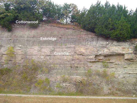
Eskridge Shale--A variegated mudrock, between 6.1 and 12.2 m (20-40 ft) thick, the Eskridge Shale overlies the Neva (fig. 20). It contains two intervals of thin limestone beds and calcareous mudrocks that can be recognized over most of the outcrop belt (Mudge and Yochelson, 1962). Pectinid and myalinid bivalves are abundant in these thin limestones, and the variegated mudrocks consist of stacked well-developed calcic and vertic paleosol profiles (Joeckel, 1991; Miller and West, 1993).
Beattie Limestone--Three members, in ascending order, the Cottonwood limestone, Florena shale, and Morrill limestone, are recognized in the Beattie Limestone, which overlies the Eskridge (fig. 21). Imbrie et al. (1964) provided a comprehensive description of this formation.
Figure 21--Exposure of the Beattie Limestone along the north side of K-18; near center of north line NW sec. 26, T. 10 S., R. 7 E., Riley County, Kansas.
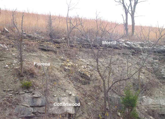
The Cottonwood is a prominent, fusulinid-bearing limestone 0.9-2.7 m (3-9 ft) thick in Kansas. A thin bed with mudrock intraclasts up to 10 cm (4 inches) in diameter, phosphatic grains, and fragments of bone and skeletal debris occurs locally near the base (Miller and West, 1993). Laporte (1962) published a detailed study of the Cottonwood from Nebraska to Oklahoma. In northern and central Kansas, Laporte recognized a lower bioclastic facies with abundant algal-coated grains (osagite) and an upper facies dominated by fusulinids. In Greenwood County, the Cottonwood is dominated by a platy alga with a cup-shaped thallus identified as Calcipatera cottonwoodensis by Torres et al. (1992). Sawin and West (2005) described a bafflestone composed of in situ Calcipatera and a packstone composed of Calcipatera fragments. These two carbonate rock types correspond to what Samankassou and West (2004) referred to, respectively, as constructional and accumulational modes of occurrence in algal mounds. South of Greenwood County the Cottonwood limestone becomes more argillaceous with a diverse brachiopod and mollusk assemblage.
The Florena shale is a 0.9-4.6-m (3-15-ft)-thick mudrock that was studied in detail by Imbrie (1955). The lower beds are typically very fossiliferous gray mudrocks dominated by brachiopods (especially Neochonetes and Derbyia). The upper part is poorly fossiliferous and dolomitic with secondary calcite filling fractures and geodes.
Two or more porous limestones with thin gray calcareous mudrock interbeds compose the Morrill, which contains skeletal fragments of brachiopods, echinoderms, bryozoans, and bivalves; locally it is stromatolitic (Mudge and Yochelson, 1962). Over much of Kansas, the Morrill has a well-developed boxwork structure of calcite-filled fractures, and it is characterized by an algal breccia facies in Greenwood County (Imbrie et al., 1964).
Stearns Shale--The Stearns Shale is a 1.5-8.8-m (5-29-ft)-thick sequence of reddish to greenish-gray stacked paleosols in its lower part, and dark-gray to olive-gray shales and mudrocks and calcareous siltstones in its upper part (Miller and West, 1993; fig. 22). A thin coal bed is locally present in Lyon and Morris counties (Zeller, 1968).
Figure 22--Exposure of the Stearns Shale on the north side of K-13 just after turning northeast off US-24 to go over the dam at Tuttle Creek Lake, SW sec. 23, T. 9 S., R. 7 E., Riley County, Kansas.
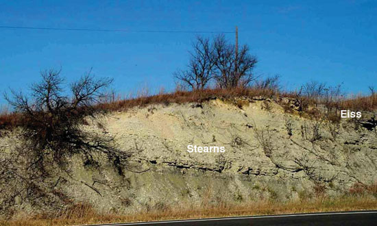
Bader Limestone--The three members of the Bader Limestone are, in ascending order, the Eiss limestone, Hooser shale, and Middleburg limestone (fig. 23). Intraclastic beds occur locally at the base of the Eiss and Middleburg, where they truncate underlying variegated mudrock units (Miller and West, 1993).
Figure 23--Exposure of the Bader Limestone on the southeast side of the access road on the north side of the interchange of I-70 and Deep Creek Road; just north of center of east line, sec. 27, T. 11 S., R. 8 E., Geary County, Kansas.
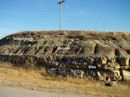
The Eiss, a thin but persistent unit, ranges from 2.1 to 5.5 m (7-18 ft) in thickness. Like most carbonate units in the Wolfcampian, it generally consists of two beds of limestone separated by a thin mudrock bed. The lower limestone bed contains a diverse brachiopod-dominated assemblage, and the upper bed is characterized by abundant pyramidellid gastropods, bivalves, and algal-coated grains (Mudge and Burton, 1959). At the base of the upper limestone, a boxwork structure is locally well developed (Miller and West, 1993). Based on conodonts the base of the Sakmarian Stage/Age is thought to be within the Eiss limestone (Mei et al., 2002; Wardlaw, 2004; Wardlaw et al., 2006; Menning et al., 2006; Sawin et al., 2008; Boardman et al., 2009); however, the International Commission on Stratigraphy has not yet established a GSSP for this boundary. A variegated mudrock unit 0.9-3.3 m (3-11 ft) thick, the Hooser consists of stacked calcic paleosol profiles, including a salt-influenced natric horizon in its upper part (McCahon and Miller, 1997). The gray to light-brown Middleburg limestone, a 0.6-2.4-m (2-8-ft)-thick unit, is characterized by abundant pyramidellid gastropods and algal-coated grains.
Easly Creek Shale--The Easly Creek is 3.05-6.1 m (10-20 ft) of variegated mudrock, the basal part of which, in northeastern Kansas, is marked by a red and green mudrock breccia that corresponds to an approximately 2-m (6.6-ft)-thick bed of gypsum in the subsurface (Miller and West, 1993). This gypsum bed is also reported in outcrop in Marshall County (Zeller, 1968). The lower part of the Easly Creek consists of stacked olive and grayish-red paleosols and beds of siltstone and fine sandstone (fig. 24). Folding and faulting are responsible for some of the local deformation of this variegated interval. This deformation is especially well displayed in K-177 roadcuts south of Manhattan (Miller and McCahon, 1999). Sharply truncating this lower variegated interval is a thin intraclastic limestone containing rounded granule to pebble-size micrite clasts, pyramidellid gastropods, and brachiopod and bivalve fragments. The overlying mudrocks are poorly fossiliferous with scattered bivalves and lingulid brachiopods (Miller and West, 1993).
Figure 24--Exposure of the Easly Creek Shale on the northwest side of the access road on the north side of the interchange of I-70 and Deep Creek Road; near center of SE NE sec. 27, T. 11 S., R. 8 E., Geary County, Kansas.
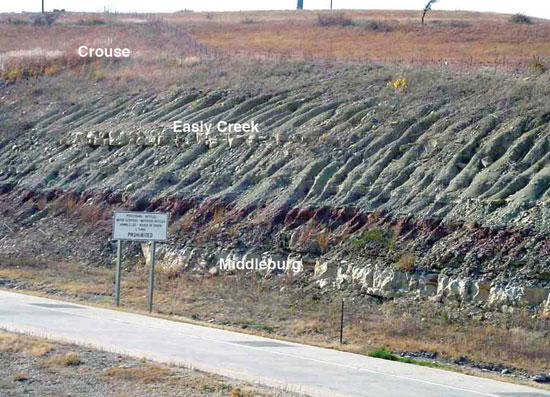
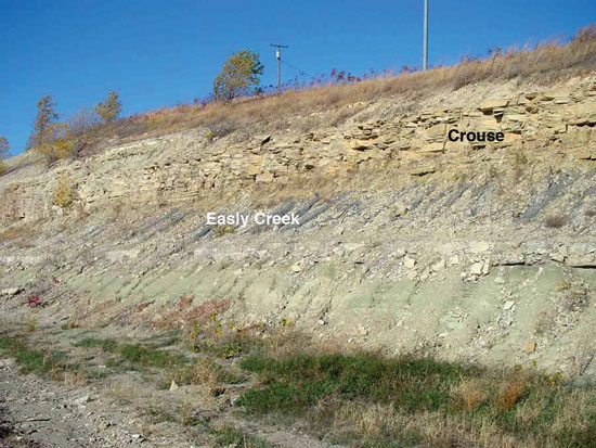
Crouse Limestone--Overlying the Easly Creek are the three widely traceable units of the 1.8-5.5-m (6-18-ft)-thick Crouse Limestone: a lower wackestone to packstone interval with pyramidellid gastropods and bivalves, a middle dolomitic mudrock, and an upper thin-bedded to laminated, dolomitic micrite with pavements of ostracodes (West et al., 1972; West and Twiss, 1988; fig. 25). The lower limestone is locally cherty.
Figure 25--Exposure of the Crouse Limestone and Easly Creek Shale on the east side of K-177 south of Manhattan just north of the Scenic Overlook; near center of east line, sec. 29, T. 10 S., R. 8 E., Riley County, Kansas.
Blue Rapids Shale--Above the Crouse is a 4.6-9.1-m (15-30-ft)-thick variegated mudrock, the Blue Rapids Shale, which consists of a series of well-developed paleosol profiles each truncated by thin calcareous beds containing ostracodes, fish bones, and intraclasts. The familiar pattern of reddish calcic paleosols with caliche nodules, overlain by greenish-gray to olive vertic paleosols (Miller and West, 1993), characterizes the Blue Rapids (fig. 26). Zeller (1968) reported a thin coaly layer within the upper part of the Blue Rapids in Geary County.
Figure 26--Exposure of the Blue Rapids Shale and Funston Limestone on the east side of K-177 south of Manhattan; along west line SW sec. 33, T. 10 S., R. 8 E., Riley County, Kansas.
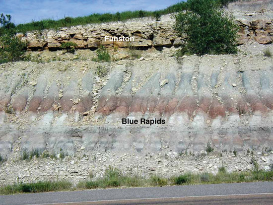
Funston Limestone--The Funston Limestone consists of gray fossiliferous limestones and yellowish-gray mudrocks and ranges from 1.5 to 8.5 m (5-28 ft) in thickness (fig. 26). It is not recognized in northern Oklahoma (Chaplin, 1988). At its base is a bed with mudrock intraclasts and fragmented skeletal debris (Miller and West, 1993). A diverse assemblage of brachiopods, bryozoans, crinoids, and mollusks characterize the lower beds; algal-coated grains and pyramidellid gastropods occur in the upper limestone. A "biostrome" of algal-bound oolitic limestone over 7.6 m (25 ft) thick is developed within the Funston in east-central Kansas (Mudge and Burton, 1959).
Speiser Shale--At the top of the Council Grove Group is 5.5-10.7 m (18-35 ft) of mudrock, the Speiser Shale, which generally thickens to the south. In northern Oklahoma where the Funston is absent, the name Speiser is used to include the interval from the top of the Crouse to the base of the Wreford Limestone (Chaplin, 1988). Like the Blue Rapids, it is composed of a stacked series of paleosols with thin truncating carbonate beds (fig. 27). Reddish and greenish-gray calcic paleosols occur in the lower part. Overlying these paleosols are vertic paleosols and laterally equivalent gray organic-rich shales (Miller and West, 1998). Schultze (1985, p. 12, fig. 9) reported skeletal remains of both marine and euryhaline vertebrates (palaoniscoids, platysomoids, acanthods, elasmobranchids, petalodontids, bradyodonts, cladodonts, xenocanthids, Gnathorhiza [lungfish], and tetrapods) with marine invertebrates in the Speiser Shale in Kansas. Amphibian burrows in the Speiser Shale were associated with ephemeral ponds (Hembree et al., 2004). A very persistent thin limestone occurs near the top of the Speiser, sharply overlying the upper paleosol. This limestone contains a diverse marine assemblage of productid brachiopods, bryozoans, crinoids, and bivalves, and is overlain by a thin, fossiliferous, gray mudrock (Miller and West, 1993).
Figure 27--Exposure of the Speiser Shale on the east side of K-177 south of Manhattan; along west line SW sec. 33, T. 10 S., R. 8 E., Riley County, Kansas.
Composite Sequences in the Council Grove Group--Boardman and Nestell (2000) and Boardman et al. (2009) identified third-, fourth-, and fifth-order depositional sequences in the Council Grove Group. Olszewski and Patzkowsy (2003) recognized two composite sequences in the lower part (from the base of the Glenrock limestone to the upper part of the Eskridge Shale) of the Council Grove Group. They termed these the Red Eagle and Grenola Composite Sequences and correlated them from Cowley County in southern Kansas to Nemaha County in northern Kansas. Correlations of meter-scale cycles within these sequences revealed angular unconformities bounding these composite depositional sequences (Olszewski and Patzkowsky, 2003, p. 28). In addition, Olszewski and Patzkowsky (2003) pointed out the importance of this sequence and smaller-scale framework to understanding the role of eustasy and climate in the rock record of this interval.
Chase Group
The Chase Group begins with the Wreford limestone, the first prominent carbonate interval containing abundant chert. The last prominent limestone of the Permian section, the Herington limestone, is the uppermost unit of the Chase Group, but it only contains chert nodules in southern Kansas (Condra and Upp, 1931; Bayne, 1962). The chert-bearing limestones of the Chase Group, primarily the Wreford (Threemile and Schroyer) and Barneston (Florence) are largely responsible for the topography of the lower Permian outcrop in Kansas, and the reason for the designation of the region as the "Flint Hills." On the basis of sequence stratigraphy, Mazzullo et al. (1997) and Mazzullo (1998) recognized a number of cycles within seven depositional sequences within the Chase Group. A detailed stratigraphic column for the Chase Group in north-central Kansas is shown in figs. 28 A, B, C, D.
Figures 28A, B, C, D--Stratigraphic sections for the Chase Group in north-central Kansas. Arrows mark flooding surfaces that bound meter-scale parasequences, and TS denotes transgressive surfaces that mark cyclothem boundaries. 28A, Threemile Limestone Member through the Schroyer Limestone Member of the Wreford Limestone sequence is from an exposure in sec. 21, T. 10 S., R. 7 E., Riley County, Kansas (modified from Miller and West, 1993); Wymore Shale Member through the Blue Springs Shale Member of the Matfield Shale is from an exposure in sec. 35, T. 9 S., R. 7 E., Riley County, Kansas. 28B, Florence Limestone Member through the Fort Riley Limestone Member of the Barneston Limestone is from an exposure in sec. 29, T. 11 S., R. 5 E., Geary County, Kansas (modified from Miller and Twiss, 1994). 28C, Holmesville Shale Member of the Doyle Shale is from an exposure in sec. 17, T. 7 S., R. 6 E., Riley County, Kansas; Gage Shale Member of the Doyle Shale through the Stovall Limestone Member of the Winfield Limestone is from an exposure in sec. 6, T. 12 S., R. 4 E., Dickinson County, Kansas. 28D, Grant Shale Member of the Winfield Limestone is from an exposure in sec. 3, T. 8 S., R. 6 E., Riley County, Kansas; Cresswell Limestone Member of the Winfield Limestone through the Herington Limestone Member of the Nolans Limestone is based on descriptions in Mazzullo et al., 1995, from south-central Kansas. See also Archer et al., 1995.
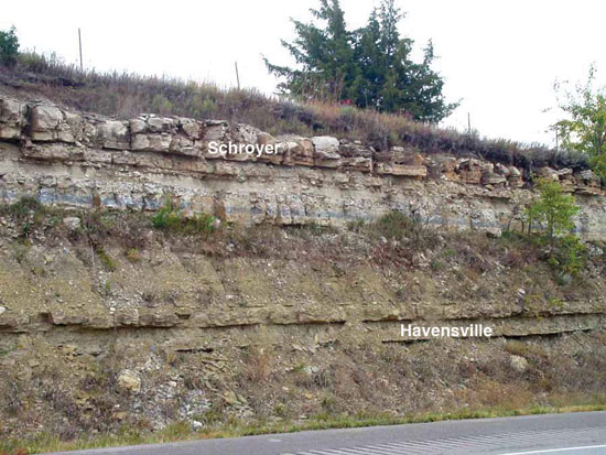
Wreford Limestone--In ascending order the Threemile limestone, Havensville shale, and Schroyer limestone, make up the Wreford Limestone (figs. 29, 30). A detailed study of the Wreford along the entire outcrop belt from Nebraska to Oklahoma was conducted by Hattin (1957). Cuffey (1967) and Lutz-Garihan and Cuffey (1979) published detailed studies of the paleoecology of the Wreford. Schultze (1985, p. 12, fig. 9) reported an assemblage of marine and euryhaline vertebrate skeletal remains from the Wreford Limestone that is similar to what occurs in the underlying Speiser Shale. As in the Speiser Shale, these vertebrate remains were associated with marine invertebrates. A few of these vertebrates also occur in the overlying Wymore shale (Schultze, 1985, p. 12, fig. 9). Abundant chert and a diverse assemblage of brachiopods (especially productids), bryozoans, and crinoids characterize the Threemile limestone.
Figure 29--Exposure of the Threemile Limestone Member of the Wreford Limestone and Speiser Shale along the east side of Scenic Drive in Manhattan, Kansas; just west of center of east line NE NE sec. 21, T. 10 S., R. 7 E., Riley County, Kansas.
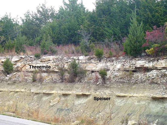
Figure 30--Exposure of the Schroyer Limestone Member and Havensville Shale Member of the Wreford Limestone along the east side of Scenic Drive in Manhattan, Kansas; near center of south line SE SE sec. 16, T. 10 S., R. 7 E., Riley County, Kansas.
The upper limestone bed of the Threemile limestone thickens dramatically to over 7.3 m (24 ft) from southern Wabaunsee to southern Chase counties (Hattin, 1957). This thickened chalky facies is dominated by bryozoans and includes corals. In southern Kansas, algal-coated grains (osagite) become abundant in the upper Threemile and infaunal bivalves (Wilkingia) are prominent.
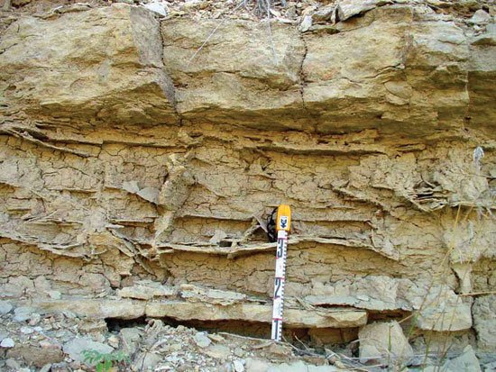
Overlying the Threemile are the gray to yellowish-gray shales and mudrocks of the Havensville shale, which varies in thickness inversely with the underlying Threemile from about 1.5 to 7.6 m (5-25 ft). It contains thin molluscan limestone beds in the north and osagite limestones with infaunal bivalves in the south (Hattin, 1957). At least in Riley County, the middle Havensville is characterized by boxwork structures (fig. 31), calcite- and quartz-replaced evaporite nodules (geodes), and thin olive-gray paleosol horizons (Miller and West, 1993).
Figure 31--Boxwork in the Havensville Shale Member of the Wreford Limestone in a roadcut exposure along the east side of Scenic Drive in Manhattan, Kansas; near center of south line SE SE sec. 16, T. 10 S., R. 7 E., Riley County, Kansas.
The Schroyer is a rather uniform cherty limestone 1.8-4 m (6-13 ft) thick with a diverse brachiopod, bryozoan, crinoid assemblage; a grainstone bed is usually present at the top.
Matfield Shale--The Matfield Shale is divided into three members, in ascending order the Wymore shale, Kinney limestone, and Blue Springs shale (fig. 32). The Wymore Shale Member, 2.7-7.6 m (9-25 ft) thick, is a variegated and silty mudrock with very well developed calcic paleosols in the lower part. These color-mottled paleosols are overlain by greenish-gray vertic paleosols (Miller and West, 1993). Williams (1972) described spiral coprolites from sharks that were collected from a lens of gray-green mudrock in the lower part of the Wymore shale. The coprolites were associated with plant debris and skeletal remains of other vertebrates and invertebrates and the depositional environment was inferred to be a freshwater marsh or swamp. McAllister (1985) provided additional information on these coprolites.
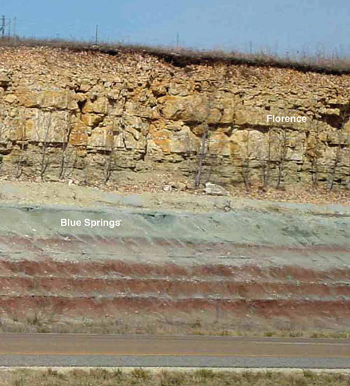
Figure 32--Exposure of the upper Matfield Shale (Kinney and Blue Springs) and lower Barneston Limestone (Florence) along the south side of I-70 just east of exit 299; near NW corner, sec. 8, T. 12 S., R. 6 E., Geary County, Kansas.
In the subsurface, at least in Riley County, the upper bed of the Wymore is 0.9 m (3 ft) of gypsum (Twiss, 1991a). Two limestone beds, between 2 and 7 m (6.5-23 ft) thick, separated by mudrock containing very thin fossiliferous limestones, constitute the Kinney. Brachiopods (particularly Derbyia and Composita) and bryozoans are common throughout the unit. The mudrocks are dark gray, green, or black to the north and yellowish gray to the south (Mazzullo, 1998). Boxwork structures are locally developed at the top of the mudrock interval in Riley County. Overlying the Kinney is 4.6-10.7 m (15-35 ft) of Blue Springs shale consisting of variegated silty mudrock with preserved stacked and truncated red and green silty paleosol profiles (fig. 33). Miller and McCahon (1999) reported several paleosols in the upper part that are capped by massively rooted siltstone beds, and that locally lungfish burrows penetrate these upper paleosols. Yellowish-gray mudrock occurs at the top of this member. Hasiotis et al. (2002) discussed this lungfish-burrowed interval.
Figure 33--Variegated mudrock in Blue Springs Shale Member of Matfield Shale with the Florence Limestone Member of the Barneston Limestone above; along the west side of K-177 at the Riley-Geary County line; near NE corner, sec. 29, T. 11 S., R. 8 E., Geary County, Kansas.
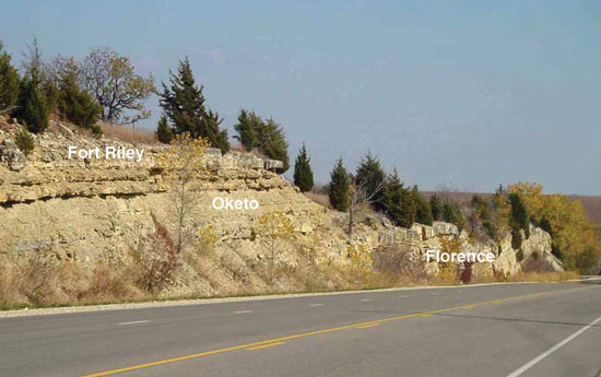
Barneston Limestone--Of all the Permian carbonate units in Kansas, the Barneston is the thickest and most prominent and its 24.4 to 27.4-m (80-90-ft) thickness is responsible for a lot of the conspicuous topographic benches over much of the Flint Hills. This formation includes three members, in ascending order: Florence limestone, Oketo shale, and Fort Riley limestone (fig. 34).
Figure 34--Exposure of the Barneston Limestone along north side of US-24 and K-177; near center of S/2 sec. 22, T. 9 S., R. 7 E., Riley County, Kansas.
The 3.7-13.7-m (12-45-ft)-thick Florence contains abundant chert nodules and beds, some of which have a branching morphology (Miller and Twiss, 1994; Twiss, 1991b, 1994; Miller, 1996). It is a fusulinid-bearing limestone with a diverse assemblage of brachiopods, bryozoans, crinoids, and echinoids. Based on conodonts, the proposed base of the Artinskian Stage/Age is thought to be within the Florence limestone (Mei et al., 2002; Wardlaw, 2004; Wardlaw et al., 2006; Sawin et al., 2008; Boardman et al., 2009), but Menning et al. (2006, p. 348) suggested it was somewhere within the interval between the Schroyer and Florence limestones (Sawin et al., 2008). The International Commission on Stratigraphy has not established a GSSP for this boundary. The Oketo shale is a thin (generally less than 1.5 m [5 ft]), silty, calcareous interval and much less fossiliferous than the Florence. It thins to the south and is not recognized south of Chase County (Mazzullo, 1998). The Fort Riley begins with a massive ledge-forming unit ("rimrock") near its base that has a diverse brachiopod, echinoderm, and bryozoan assemblage and is often bioturbated (burrows and borings; figs 35, 36). To the south this interval becomes oncolitic with algal-coated grains (osagite). The presence of this algal facies marks the base of the Fort Riley equivalent in outcrop and core (Toomey, 1992; Mazzullo, 1998). Above this massive unit, the Fort Riley becomes thin bedded and dominated by an assemblage of pectinids, myalinids, and Permorphorus. The upper Fort Riley becomes increasingly dolomitic upward with voids from dissolved evaporite nodules, algal laminations, and desiccation polygons (Miller and Twiss, 1994). In the subsurface of Riley County, the uppermost Fort Riley contains several thin gypsum beds (Twiss, 1991a).
Figure 35--Fort Riley limestone "rimrock" along the east side of Lyons Creek Road; near the east side of NW sec. 20, T. 13 S., R. 5 E., Geary County, Kansas.
Figure 36--Exposure of the Fort Riley limestone along north side of US-24 and K-177; near center of S/2 sec. 22, T. 9 S., R. 7 E., Riley County, Kansas.
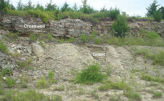
Doyle Shale--Three members are differentiated in the Doyle Shale (figs. 37, 38). These are, in ascending order, the Holmesville shale, Towanda limestone, and Gage shale. The Holmesville is a variegated mudrock 2.1 to 10.1 m (7-33 ft) thick. A very well developed boxwork (see fig. 39) capped by teepee structures occurs in the lower part of this unit in Geary County and is overlain by a red silty paleosol (Miller and Twiss, 1994). A dark-colored mudrock occurs in the upper Holmesville in the central and southern parts of the outcrop belt (Mazzullo, 1998). The Towanda is generally a slabby to platy, yellowish-gray limestone 2 to 4.9 m (6.5-16 ft) thick. It consists of carbonate mudrocks, brecciated carbonate mudrocks, and foraminiferal wackestones and packstones. The former presence of evaporites is indicated by molds of evaporite nodules (Mazzullo, 1998). The Gage consists of variegated mudrocks and siltstones 5.8 to 10.1 m (19-33 ft) thick. A variegated appearance is reflected by the stacked sequence of red and green silty paleosols and rooted siltstones in the Gage. Frequent laminae of calcite and laminar pores suggest dissolution and replacement of former evaporite layers (fig. 40). The upper Gage is a gray, calcareous mudrock with a moderately diverse assemblage of articulate and inarticulate brachiopods, and pectinid and myalinid bivalves. In Dickinson County, the base of the Gage is coarsely brecciated and normal faults cut through the entire interval (Miller and McCahon, 1999).
Figure 37--Exposure of the Doyle Shale [upper Holmesville Shale Member (mostly covered by limestone rubble from Towanda) and Towanda Limestone Member] approximately 1.1 mi (1.8 km) north of the junction of K-24 with US-77 and K-177 along the west side of US-77; near center of east line of NE sec. 33, T. 8 S., R. 6 E., Riley County, Kansas.
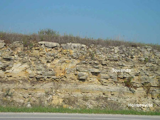
Figure 38--Doyle Shale (Gage Shale Member) approximately 8.7 mi (13.9 km) north of junction of K-24 with US-77 and K-177 along the east side of US-77; near center of north line of sec. 28, T. 7 S., R. 6 E., Riley County, Kansas.
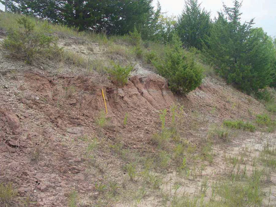
Figure 39--Boxwork in the Gage Shale Member (Doyle Shale) on the north side of the roadcut along old US-40 just west of Chapman, Kansas; near center of south line of N/2 NW sec. 31, T. 12 S, R. 4 E., Dickinson County, Kansas.
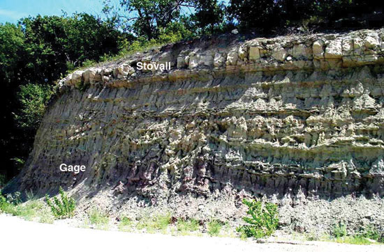
Figure 40--Exposure of the Doyle Shale (Gage Shale Member) and Winfield Limestone (Stovall Limestone Member) in a roadcut on the east side of Trail Road; north of center of west line sec. 3, T. 15 S., R. 4 E., Dickinson County, Kansas.
Winfield Limestone--The 7-13.7-m (23-45-ft)-thick Winfield Limestone is divided into three members, in ascending order, the Stovall limestone, Grant shale, and Cresswell limestone (fig. 41). The Stovall is a very thin limestone nearly everywhere less than 0.9 m (3 ft) thick, typically 0.3-0.5 m (1-1.5) ft thick. Over much of the outcrop belt, it contains abundant chert and a fossil assemblage of brachiopods, bryozoans, and crinoid ossicles. In southern Kansas it becomes a thin shaly calcareous mudrock with bivalves and occasionally oncolites (Mazzullo et al., 1995, 1997; Mazzullo, 1998). Brachiopods, bivalves, bryozoans, and crinoids characterize the 2 to 4-m (6.5-13-ft)-thick gray to yellowish-gray Grant shale. In southern Kansas the Grant is a shaly wackestone to packstone with abundant oncolites (Mazzullo et al., 1995, 1997). The Cresswell is a massive limestone with abundant large concretions and scattered chert nodules (fig. 42). Thin-bedded and shaly limestone beds, previously referred to as the "Luta limestone" (Zeller, 1968, p. 49), occur above this massive limestone. The combined interval ranges in thickness from 3 to 11 m (10-36 ft), with a dramatic thickening in Marion County (Mazzullo, 1998). The lower Cresswell is quite fossiliferous with echinoid spines, bryozoans, and brachiopods being common. To the south, this interval becomes an oncolite grainstone with infaunal bivalves. The upper Cresswell consists of carbonate mudrock with cryptalgal laminations, silicified evaporite nodules, evaporite molds, and desiccation polygons (Mazzullo, 1998).
Figure 41--Exposure of Doyle Shale (Gage Shale Member) and Winfield Limestone (Stovall, Grant, and Cresswell) in a roadcut on the north side of old US-40 just west of Chapman, Kansas; near center of south line of N/2 NW sec. 31, T. 12 S, R. 4 E., Dickinson County, Kansas.
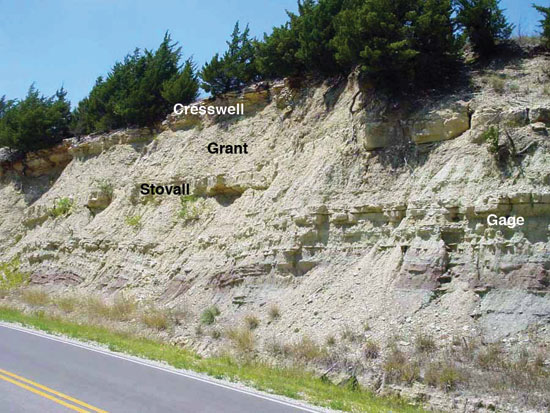
Figure 42--Exposure of the Winfield Limestone (Grant Shale Member and Cresswell Limestone Member) in a roadcut along the south side of I-70 on the west side of Exit 286 at Chapman, Kansas; south and east of center of S/2 sec. 19, T. 12 S., R. 4 E., Dickinson County, Kansas.
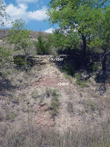
Odell Shale--Overlying the Winfield is the Odell Shale, another variegated mudrock unit that ranges from 6.1 to 12.2 m (20-40 ft) thick. Calcareous shales at the top and bottom are transitional with the over- and underlying carbonates (figs. 43, 44). The base of the Odell Shale has been suggested as the possible base of the Kungurian Stage/Age (Menning et al., 2006), but they noted that this position is questionable (Sawin et al., 2008). The Kungurian Stage/Age is not represented by good marine fossils in Kansas (Wardlaw, 2004).
Figure 43--Exposure of the Odell Shale in a roadcut approximately 1.5 mi (2.4 km) north of the junction of US-36 and K-148 on the west side of K-148; near center of east line, sec. 21, T. 2 S., R. 5 E., Washington County, Kansas.
Figure 44--Exposure of the Odell Shale and Nolans Limestone (Krider Limestone Member) in a roadcut on the north side of the road; near the center of north line NW sec. 20, T. 12 S., R. 4 E., Dickinson County, Kansas.
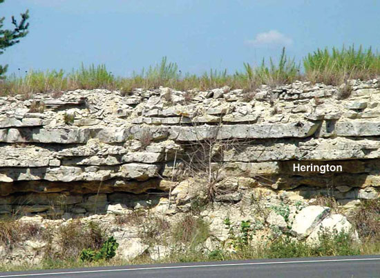
Nolans Limestone--The uppermost formation of the Chase Group in Kansas, the Nolans Limestone, is 7 to 11 m (23-36 ft) thick, and consists of, from bottom to top, the Krider limestone, Paddock shale, and Herington limestone (fig. 45, 46). The Krider is 0.7 to 2.8 m (2.4-9.3 ft) of porous dolomites and mudrocks to the north and relatively fossiliferous limestones and mudrocks to the south (Mazzullo et al., 1995, 1997) with the maximum thickness in southernmost Cowley County (Mazzullo et al., 1997, p. 104). It contains bivalves, pyramidellid gastropods, brachiopods, bryozoans, and crinoids. An olive to yellowish-gray poorly fossiliferous mudrock, 3 to 4.9 m (10-16 ft) thick, is defined as the Paddock. In the south it is composed of yellowish-gray calcareous mudrocks with bivalves and brachiopods. Within the mudrock are cryptalgal laminations, calcite-replaced evaporite nodules, and laminae of "palisade calcite crystals" (Mazzullo et al., 1995, 1997). The upper surface of the Herington, the uppermost carbonate of the Wolfcampian, marks the top of the Chase Group. It is a 2 to 4.9-m (6.5-16-ft)-thick interval of calcitic dolomites and laminated dolomites (fig. 47). Calcite and silica-replaced evaporite nodules (geodes) are typically abundant. At the base, where it is fossiliferous, it contains an assemblage of pectinids, myalinids, and gastropods.
Figure 45--Exposure of the Odell Shale and Nolans Limestone (Krider Limestone Member, grass-covered Paddock Shale Member, and rubble of the Herington Limestone Member) in a roadcut on the east side of Rain Road; near center of west line, sec. 17, T. 12 S., R. 4 E., Dickinson County, Kansas.
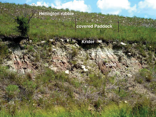
Figure 46--Exposure of the Nolans Limestone (Paddock Shale Member and Herington Limestone Member) on the east side of Rain Road; along the west line, sec. 17, T. 12 S., R. 4 E., Dickinson County, Kansas.
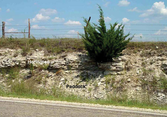
Figure 47--Exposure of the Nolans Limestone (Herington Limestone Member) in a roadcut on the west side of US-77; SW sec. 24, T. 16 S., R. 4 E., Dickinson County, Kansas.
Upper Boundary of the Wolfcampian
The Chase Group was defined by Prosser (1895, 1902) on the basis of chert content, and included the prominent chert-bearing carbonate units of the "Wreford Limestone, Florence Flint, Fort Riley Limestone, and Winfield Limestone." As noted by Condra and Upp (1931), although the formations included were readily identifiable, the definition of the group was not well founded. They stated (p. 30), "... it should not be overlooked that chert occurs, but in less abundance, in all the limestone members of the so-called Council Grove group and that it is found as high as the Herington limestone in the vicinity of Arkansas City, Kansas." The Chase Group was, in fact, later extended into what was then the overlying Sumner Group to incorporate units up to and including the Herington Limestone (Moore, Frye, et al., 1951).
Lithofacies and Thickness of the Wolfcampian
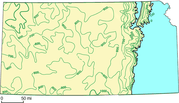
General thickness and lithologic trends of the Wolfcampian in Kansas are well summarized by Mudge (1967) with the greatest thickness in the south-central part of the state, the Kansas Permian basin (fig. 48), thinning toward the Nemaha anticline and the outcrop belt to the east, and to the northwest where its thickness is reduced by about half (Mudge, 1967). McKee and Oriel (1967, p. 7) referred to this area as the Kansas depositional basin that is defined by the Nemaha anticline on the east and by the Las Animas arch on the west (see fig. 49). The structural Anadarko basin lies to the south, but was separated from the deep basins of west Texas by the Amarillo-Wichita and Arbuckle belt of uplifts. Because there was no true shelf edge, the Kansas depositional basin is best described as a ramp. In northeastern Kansas, lower Permian rocks are exposed east of the Nemaha anticline (fig. 48) as an outlier due to post-Permian erosion. To the southeast, the Cherokee basin lies east of the Nemaha and south of the southeast-trending Bourbon arch. The influence of the Bourbon arch is seen in local thickness and facies changes. The presence of the Central Kansas uplift is indicated by a gradual thinning of rocks of this interval in central and northern Kansas. To the west, Wolfcampian rocks thin over the Las Animas arch that extends from southeastern Colorado toward southwestern Nebraska and separates the Hugoton embayment of the Anadarko basin from the Denver basin. Mudge (1967) described several general lithologic trends across what he referred to as the Kansas basin, or Kansas depositional basin. The carbonate percentage increases toward the basin center in south-central Kansas, western Oklahoma, and the Texas Panhandle. The abundance of chert also increases in these carbonates toward the basin center. Mudge (1967, p. 103) stated "In the central parts of the basin, chert is common to abundant in many limestone beds. Toward the northeast margin of the basin, it occurs only in some beds, the Beattie, Wreford, and Barneston Limestones. At the edge of the platform, in western Kansas, chert is sparse, and on the platform it is absent." Another trend within the carbonate units is a decrease in the dolomite-to-limestone ratio toward the basin center. Moving from the more marginal depositional settings of the west and northwest toward the southeast, the earliest occurrence of dolomite beds moves progressively upsection. In northwestern Nebraska and north-central Colorado, the equivalents of the Council Grove and Chase Groups are dominantly dolomite and anhydrite. Along with an increase in dolomite toward the basin margins to the west and northwest is an increase in the proportion of red clastics. Extensive core data from the Hugoton embayment in the southwest reveals other broad lithofacies trends. The marine units of the Hugoton not only include limestones and dolomites, which may be sandy or argillaceous, but also marine siltstones and sandstones. Within the carbonates, anhydrite is locally common and chert is largely absent. These marine units alternate with red siltstones and fine sandstones (Caldwell, 1991; Olson et al., 1997). This increased clastic content reflects the paleogeographic position of the Hugoton on the northwestern margin of the Anadarko basin on a shallow eastward-dipping ramp where siliciclastics were being shed into the basin from the Ancestral Rockies and Sierra Grande uplifts to the west (Rascoe, 1988). Several lithologic trends can be observed from north to south along the eastern outcrop belt. Substantial lithologic changes are largely confined to southern Kansas and northeastern Oklahoma. Dramatic changes occur within the Council Grove and Chase Groups in Kay County, Oklahoma, just south of the Kansas border (Chaplin, 1988). Although the aggregate thickness of the interval remains relatively constant, the general pattern is one of thinning and loss of carbonate units and the thickening and coarsening of siliciclastic units. As in the Hugoton on the western basin margin, there is a loss of chert and an increase in the silt and sand content of the carbonates. Several of the thinner, shallower-water limestone units, particularly those of the upper Council Grove Group, are lost or locally cut out to the south. Referring to the Council Grove Group, Chaplin (1988, p. 92) stated that these units are "the most variable in lithology, thickness, and lateral extent of the entire Lower (sic) Permian section, not only in Oklahoma but also in Kansas and Nebraska." For this reason Chaplin (1988, p. 92) provisionally reintroduced the Garrison Formation of Prosser (1902) for the interval from the top of the Cottonwood limestone to the base of the Threemile limestone. This leaves the Cottonwood limestone as the only member of the Beattie Limestone (Chaplin, 1988, p. 95, fig. 10). In neither text nor figures does Chaplin indicate that he would now consider the Cottonwood as a formation and the Florena, Morrill, Stearns, Eiss, Hooser, Middleburg, Easly Creek, Crouse, Blue Rapids, Funston, and Speiser as members of the Garrison Formation. Another trend is the loss of the tripartite subdivision of the limestone formations typical from Nebraska to central Kansas. The central shaly intervals either pinch out or pass laterally into carbonates to the south. The member subdivisions of most limestone formations (e.g., Red Eagle, Beattie, Wreford, Barneston, Winfield, Nolans) are thus difficult, if not impossible, to recognize (McCrone, 1963; Chaplin, 1988; Mazzullo et al., 1995, 1997; Mazzullo, 1998).
Figure 48--Isopach map of Wolfcampian rocks in Kansas; isopach interval = 100 ft; rocks older than Permian exposed in blue area (modified from Mudge, 1967, p. 102, fig. 34).
Several important temporal lithofacies trends occur within the latest Carboniferous and earliest Permian sequence, which reflect changes in clastic source areas, as well as changes in sea level and climate. An important study in this regard is that of Olszewski and Patzkowsky (2003). In contrast with the Virgilian, the lower Wolfcampian (Council Grove Group) has little coarse clastic input and virtually no alluvial or channel sandstones (Mudge, 1967). Coarse clastics from the south appear to have been trapped in the subsiding Anadarko basin, and the only sandstones occur near source areas to the southwest. By the upper Wolfcampian (Chase Group), the major source areas lay to the west (Mudge, 1967). This input was from the positive elements of the Ancestral Rockies, including the Sangre de Cristo, Ancestral Front Range, and Wet Mountains uplifts. According to Rascoe (1988), the Amarillo and Wichita uplifts were partially buried by Wolfcampian arkosic sediments and covered by carbonates stratigraphically equivalent to the Chase Group, suggesting diminished tectonism and basin filling. In turn, these processes probably contributed to the rather abrupt onset of evaporites in the Wellington Formation because marine circulation in the Kansas depositional basin was restricted.
In addition to the evidence of changing patterns of clastic influx, several lithologic trends suggest a long-term shallowing trend from the upper Carboniferous (Pennsylvanian) through the Permian (West et al., 1997) and the occurrence of angular unconformities (Olszewski and Patzkowsky, 2003). Conodont-rich phosphatic black shales, interpreted as representing relatively deep anoxic waters (Heckel and Baesemann, 1975; Heckel, 1977), are rare by the early Wolfcampian and absent thereafter. Marine limestones and fossiliferous mudrocks are prominent through the Wolfcampian but decline rapidly in the Leonardian, and variegated mudrocks with well-developed paleosols increase, as do evaporites, ranging from marine deposits (bedded halite with elevated bromine in the early Leonardian Wellington Formation) to nonmarine (chaotic red-bed halite in the Leonardian Blaine Formation) (Holdaway, 1978; Watney et al., 1988). Although progressive shallowing as seen in the midcontinent is also apparent on a global scale, it was not a smooth, continuous trend, with some reversals as noted by Olszewski and Patzkowsky (2001, 2003). The increasing emergence of continents through the Carboniferous and Permian is reflected in the global sea-level curves of Vail et al. (1977) and in the estimates of continental area-elevation distributions of Algeo and Wilkinson (1991). The global shallowing trend of the late Paleozoic may be a consequence of changes in elevation of the continent due to thermal uplift and changes in the volume of the mid-ocean ridges. According to Veevers (1994), assembly of the Pangean supercontinent trapped mantle heat beneath the thickened continental crust. The resulting thermal uplift of Pangea is estimated by Veevers to have reached a maximum in the early Permian. Also, Fischer (1984) argued that by the early Permian the mid-ocean ridge within the single Panthalassan ocean was both slow-spreading and greatly reduced in length, and would have displaced less water, thus lowering global sea level.
In addition to the regional thickness and lithofacies trends within the Kansas depositional basin as defined by Mudge (1967), there are significant local lateral facies changes. Many of these facies changes appear to be spatially related to basement structural controls (fig. 49). In several cases, thickened carbonate deposits are developed on or near known structural highs (Mudge, 1967; Burchett et al., 1985). The Bennett shale changes facies and thickens into a brachiopod, bryozoan, and crinoid limestone up to 9.1 m (30 ft) thick just north of the southeast-trending Bourbon arch in east-central Kansas (McCrone, 1963). Higher in the section, the Funston Limestone thickens to over 7.9 m (26 ft) of algae-bound oolite over the faulted eastern flank of the Nemaha anticline just to the west (Mudge and Burton, 1959). Similarly, the Threemile limestone thickens to 7.6 m (25 ft) of chalky limestone with bryozoans, brachiopods, and crinoids over the Nemaha anticline from southern Wabaunsee to southern Chase counties (Hattin, 1957). A bedded packstone, 3 m (10 ft) thick, containing a diverse brachiopod and molluscan assemblage and wood and fossil leaves, is developed within the overlying Havensville shale on the crest of the Nemaha anticline farther to the north (Miller et al., 1992; Mazzullo, 1998). The internal inclined truncation surfaces suggest that it may represent a shallow nearshore bank of transported bioclastic debris. Several stratigraphic intervals are observed to thin where they cross structural highs. McCrone (1963) described the absence of the Glenrock limestone and the truncation of the underlying Johnson Shale over the Nemaha anticline in southeastern Riley and northern Wabaunsee counties, with conglomeratic facies developed on the flanks of the high. The Beattie Limestone shows an overall thinning and a marked facies transition in southeastern Chase and western Greenwood counties. Laporte (1962) and Imbrie et al. (1964) attribute these trends to a topographic high they named the "Greenwood Shoal" that may be equivalent to the Otto-Beaumont anticline, which parallels the Nemaha to the east (McCrone, 1963). Higher in the Council Grove section, the Crouse Limestone thins toward the faulted eastern side of the Nemaha with the loss of the middle shaly interval (West, 1972; West and Twiss, 1988). Another interesting trend is developed within the paleosol-dominated Speiser Shale in northern Geary and southern Riley counties. Associated with an overall thinning of the Speiser Shale onto the Nemaha anticline is a transition from a series of stacked paleosol profiles to a single well-developed profile (Miller and West, 1998). This pattern suggests a more stable, continuously exposed, soil-forming environment on the crest of the anticline. Not all variegated mudrock units show this pattern, and indeed the stratigraphically older Blue Rapids Shale shows no thinning. This may suggest episodic tectonic activity along the Nemaha during Council Grove time.
Figure 49--Tectonic features of Kansas and adjacent areas (modified from Chaplin, 1988, p. 82, fig. 3) overlain on the Permian outcrop in eastern Kansas (modified from Chaplin, 1988, p. 80, fig. 1).
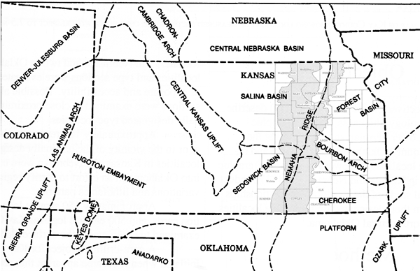
Structural control of facies in the Chase Group is not seen as clearly as in the Council Grove Group. This may be due, in part, to the more western position of most of the outcrop belt farther from the crest of the Nemaha anticline. However, thickening and thinning trends are observed (Mazzullo, 1998) and are probably related to the structure of the underlying basement rocks (fig. 49). The upper Kinney limestone thickens in Chase County, suggesting more accommodation space where it overlies a graben in the Nemaha anticline. The peritidal facies of the upper Cresswell limestone similarly thickens in Marion County on the western side of the Nemaha at the margin of the Sedgwick basin. Within both the Fort Riley and Towanda limestones, the development of peritidal facies and crossbedded sandstones seems to be controlled by proximity to the Nemaha anticline (Mazzullo, 1998). Basement reactivation seems to have affected thickness and lithofacies of the lower Leonardian Wellington Formation along km-scale, deep-seated structural lineaments (Watney et al., 2003).
Depositional Environments and Source Areas of the Wolfcampian
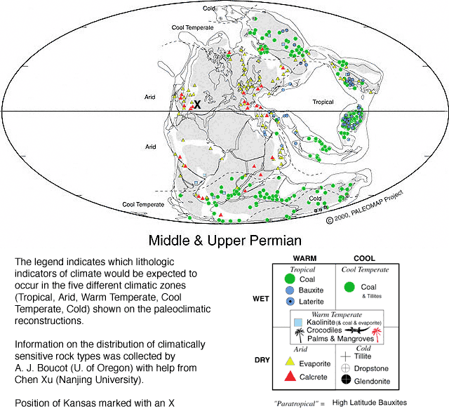
The Permian rocks of Kansas record sedimentation in a shallow shelf/ramp setting far from the shelf edge and equally far from potential clastic source areas (McKee and Oriel, 1967; Mudge, 1967; Heckel, 1980; Rascoe and Adler, 1983; Rascoe, 1988). The midcontinent epeiric sea was relatively restricted with limited connections to the open ocean to the southwest between the Amarillo-Wichita and Apishapa uplifts, and to the west through breaks in the Ancestral Rockies (McKee and Oriel, 1967). A paleogeographic reconstruction for Kansas during the Wolfcampian is shown in fig. 50. Figures 51 and 52 are global paleogeographic maps for the Permian with the position of Kansas marked with an X.
Figure 50--Paleogeography of Kansas during the late Wolfcampian; modified from Rascoe (1988).
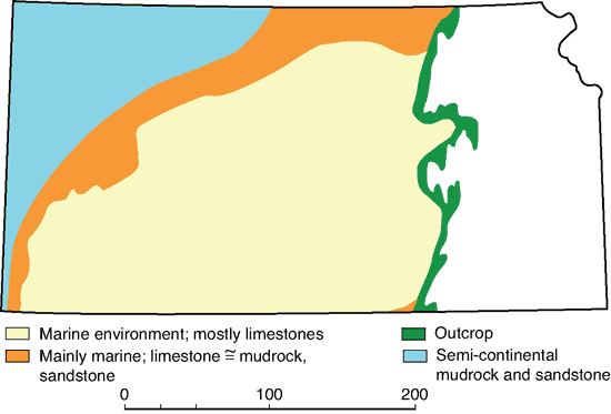
Figure 51--Global paleogeographic map and the inferred climate of the lower Permian (280 Ma); modified from Scotese, 2001, online at http://www.scotese.com/epermcli.htm.
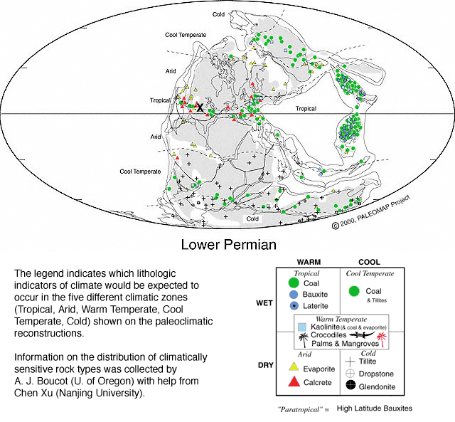
Figure 52--Global paleogeographic map and the inferred climate of the middle and upper Permian (255 Ma); modified from Scotese, 2001, online at http://www.scotese.com/lpermcli.htm.
Assembly of the Pangean supercontinent was in its final stages during the Permian. Virgilian to Wolfcampian rocks record the final collision between Gondwana and Laurasia at the western end of the Ouachita-Marathon-Huastecan orogenic belt (Rowley et al., 1985), a tectonically active area and a southern source area for clastics. To the west, the positive elements of the Ancestral Front Range, Wet Mountains, and Sangre de Cristo uplift shed large volumes of clastic sediment to form the thick Fountain Formation in Colorado (Mudge, 1967; McKee and Oriel, 1967; Soreghan, 1994). Extensive eolian-sand seas developed from the Permian into the Triassic within the U.S. Western Interior (Peterson, 1988; Parrish and Peterson, 1988; Soreghan, 1992). The Apishapa-Sierra Grande uplift of southeastern Colorado was probably a stable low-lying area but was at times a source of arkosic sediment (Mudge, 1967). East of the midcontinent was a broad low-lying landmass extending to the now (Permian) eroding Appalachian orogen. As coarse clastics from the Appalachians accumulated in the small Permian basin of the Allegheny region to form the Dunkard Group, large volumes of sediment also were transported to the west and south, but little, if any, reached Kansas.
Moving gradually northward throughout the Permian, the midcontinent lay in generally tropical to subtropical latitudes. Paleogeographical reconstructions indicate paleolatitudes for Kansas ranging from the equatorial belt to approximately 15 degrees north (see Scotese and McKerrow, 1990, figs. 10-13). Based on paleogeographic reconstructions and lithologic and paleontologic data, Ziegler et al. (1998) have attempted reconstructions for the geographic distribution of water-mass characteristics for the Permian. They concluded there was a rapid transition in the early Permian from brackish conditions in the Permian basin of west Texas, to normal-marine salinities associated with the carbonate buildups of the Texas/New Mexico border region, to increasingly higher salinities toward the Denver and Williston basins to the north. Evaporitic conditions became more dominant later during the Permian in the region.
One of the persistent debates about the depositional environments of the midcontinent Permian concerns the bathymetric interpretation of the marine facies. In his description of lower Paleozoic cyclicity in Kansas, Elias (1937) arranged lithologies and fossil assemblages into an onshore-offshore gradient. Seven "phases" were recognized: 1) red shale phase, 2) green shale phase, 3) Lingula phase, 4) molluscan phase, 5) mixed phase, 6) brachiopod phase, and 7) fusulinid phase. In his model, these phases recorded progressively deeper environments from terrestrial to deep shelf settings, respectively.
Abundant fusulinids occur only within the Glenrock limestone of the Red Eagle Limestone, the Neva limestone of the Grenola Limestone, the Cottonwood limestone of the Beattie Limestone, and the Florence limestone of the Barneston Limestone. Elias (1937, 1964) interpreted fusulinid-bearing limestones and calcareous mudrocks as representing the deepest-water facies with estimated water depths of 60 m (195 ft). Mudge and Yochelson (1962) subsequently questioned this paleoecological interpretation of fusulind occurrences and cited evidence that modern, large benthic foraminifera occupy a wide range of environments from near intertidal to deep marine. Other workers (Laporte, 1962; McCrone, 1963, 1964; Imbrie et al., 1964; Lane, 1964) placed maximum water depths at less than 20 m (65 ft), based primarily on paleoecological interpretations of marine-fossil assemblages, and on the recognition of sedimentary indicators of shallow water. One major factor in this reappraisal was the recognition that fusulinids were commonly associated with algal-coated (osagite) grains and other indicators of current and wave agitation such as finely comminuted skeletal debris and oolites. Lane (1964) also argued that fusulinids may have had algal symbionts and thus required shallow well-lit waters. More recent work (Ross, 1982) has supported the view that most species of fusulinids were benthic and lived in relatively shallow carbonate depositional settings including back-reef lagoonal environments.
Elias estimated the depth range of the brachiopod phase as 30-50 m (97.5-162.5 ft) based on the argument that most modern articulate or calcareous brachiopods live below a depth of 30 m (97.5 ft). Important constituents in the brachiopod-dominated assemblages are bryozoans, crinoids, and echinoids. Fusulinid-rich biofacies commonly grade both vertically and laterally into brachiopod and mixed brachiopod/molluscan biofacies (Lane, 1958; Laporte, 1962; Mazzullo et al., 1995, 1997). Limestones characterized by the brachiopod and mixed assemblages typically occur in the lower beds of carbonate formations and members. Some of these units also contain algal-coated grains (osagite) or, locally, even oncolites. Platy algal facies occur in both the Neva and Cottonwood limestones (Laporte, 1962; Miller and West, 1993; Torres et al., 1992; Sawin and West, 2005). Brachiopod and mixed assemblages also occur within fossiliferous calcareous gray mudrocks located between, or immediately below these marine limestones. Nearly all workers have concluded that the fusulinid, brachiopod, and mixed mollusk-brachiopod phases all represent similarly shallow-marine environments. Mudge and Yochelson (1962) concluded from their paleontological study of the lowermost Permian that depth was not a significant factor in controlling the distribution of these marine-fossil assemblages. Similarly, based on his detailed study of the Cottonwood limestone, Laporte (1962) stated that turbulence, clastic sediment influx, and water circulation, rather than depth, were the critical controls.
Elias (1937) estimated a depth range of 20-30 m (65-97.5 ft) for his molluscan phase. This occupied an intermediate position between what he recognized as the shallowest limit for articulate brachiopods and the deepest occurrence of modern Lingula. Mollusk-dominated biofacies tend to occur in the upper parts of some carbonate units (e.g., Bader, Crouse, Barneston, Winfield, and Nolans) in the Council Grove and lower Chase Groups, and in thin limestone beds within mudrock units (e.g., Legion, Salem Point, Eskridge, and Havensville) (Hattin, 1957; Lane, 1958; Miller and West, 1993; Mazzullo et al., 1995, 1997). The most diagnostic taxa are Aviculopecten, Septimyalina, and Permophorus, with pyramidellid gastropods and ostracodes being common associates. Permophorus occurs in otherwise fossil-poor, thin-bedded to laminated micritic limestones, often in nearly monospecific bedding-plane accumulations. Some mollusk-dominated facies also include algal-coated grains. The Sallyards limestone, for example, has locally abundant algal-coated bivalve shells forming algal biscuits (Lane, 1958; Miller and West, 1993). One common facies is characterized by abundant algal-coated grains (osagite) with a low-diversity assemblage of small pyramidellid gastropods, ostracodes, and, sometimes, arenaceous foraminiferids. Lane (1958) estimated water depths of about 20 m (65.6 ft) for the development of such "osagites" by analogy with the Bahama Banks. Interestingly, facies of the molluscan phase are commonly associated with evidence of evaporitic conditions. The mollusk-dominated limestones of the upper Burr, Crouse, and upper Fort Riley limestones contain molds of evaporite nodules or crystal laths (West, 1972; Miller and West, 1993; Miller and Twiss, 1994; Mazzullo et al., 1995, 1997). Quartz- and calcite-replaced evaporite nodules and boxwork structures are abundant in the Havensville shale (Miller and West, 1993), and gypsum beds overlie the Burr, Middleburg, and Fort Riley limestones in the subsurface (Twiss, 1991a). Furthermore, the thin-bedded to laminated carbonate mudstones of some molluscan facies, combined with a restricted biotic assemblage, indicate peritidal conditions. Both the upper Crouse and the upper Fort Riley, for example, have been interpreted as recording intertidal to supratidal environments (West, 1972; West and Twiss, 1988; Mazzullo, 1998; Mazzullo et al., 1995, 1997). As noted above, the molluscan facies tend to grade into peritidal deposits suggestive of sabkha-like environments. These peritidal limestones and calcitic dolomites dominate the stratigraphic interval above the Barneston Limestone (the upper Chase Group). This facies characterizes the Towanda, Stovall, Cresswell, and Herington limestones. These carbonate mudstones are typically unfossiliferous to very poorly fossiliferous with rare bivalves, arenaceous foraminiferids, and algal laminites or oncolites. Typical features include cryptalgal laminites, laminated dolomites, evaporite molds, calcite- and quartz-replaced evaporite nodules, and desiccation polygons (Mazzullo et al., 1995, 1997).
The Lingula phase is characterized by inarticulate brachiopods, particularly Orbiculoidea, and is represented by dark-gray to black shales. Interestingly, only a few shale beds within the Wolfcampian actually contain abundant inarticulate brachiopods. The two most significant are the Bennett shale and the black shale beds within the lower Neva limestone (Condra and Busby, 1933; McCrone, 1963). These shales also contain conodonts, shark teeth, and locally fusulinids. The Bennett changes facies laterally into a brachiopod, bryozoan, and crinoidal limestone; however, this is not supported by tracing genetic surfaces associated with this unit (Olszewski and Patzkowsky, 2003). To the south inarticulate brachiopods are absent from a mudrock within the Neva, and the assemblage includes fusulinids, ostracodes, conodonts, bryozoans, and productid brachiopods (Lane, 1958). These Lingula-phase shales thus grade into brachiopod- and fusulinid-phase facies. Elias (1937) suggested a depth range for the Lingula phase at 32 to 64 ft (10-20 m), and although Mudge and Yochelson (1962) suggested even shallower depths, no values were given.
Most early workers were unanimous in associating inarticulate brachiopods, the Lingula phase, with very shallow, even freshwater-influenced environments (Lane, 1964). However, the facies relationships and associated microfossils seem at odds with this interpretation. In fact, examination of the sea-level curves of Elias (1937) shows that he did not, in fact, interpret these units as shallow water. Furthermore, recent micropaleontological studies of the Wolfcampian by Boardman (1993) have identified so-called deep-water conodont species in both the Bennett shale and shales within the Neva limestone. Only one other such conodont interval has been recognized in the lower Permian and that is within the lower Florence limestone. Ironically, the facies most confidently assigned to the shallowest environments may actually record a deeper one. However, another possibility pointed out by Olszewski (personal communication, 2006) is that there are two distinct lingulid associations, one shallow and the other deeper water. These shales, however thin, are widespread and generally serve as good subsurface markers.
Other poorly fossiliferous dark-gray to black mudrocks occur within the Council Grove stratigraphic interval, but these lack both deep-water conodonts and abundant inarticulate brachiopods. These units include the Legion, dark-gray mudrocks within the Burr limestone, and the Salem Point. These units are characterized by ostracodes, occasional small bivalves, and carbonized plant fragments (Miller and West, 1993). Lane (1964) identified freshwater ostracode taxa and charophytes from the Salem Point. Interestingly, evidence of subaerial exposure, including natric paleosol horizons, is present in the Legion and Salem Point (McCahon and Miller, 1997). These dark mudrock units appear to record shallow, marginal-marine environments. In contrast to the black phosphatic "core shales" typical of the upper Carboniferous (Pennsylvanian, Missourian) cyclothems of the midcontinent (Heckel and Baesemann, 1975; Heckel, 1977), these organic-rich facies may have been the result of periods of high freshwater runoff into the basin (Olszewski, 1996).
Elias (1937) divided the variegated mudrocks of the lower Permian into green- and red-shale phases. Greenish-gray to yellowish-gray mudrocks typically overlie the reddish intervals within these stratigraphic units (e.g., Roca, Eskridge, Stearns, Blue Rapids, Speiser, Wymore, Blue Springs, Holmesville, Gage, and Grant). Like Elias, most early workers interpreted the red units as recording terrestrial conditions and the green shales as representing shallow subtidal environments. However, this interpretation is probably incorrect based on the recognition that the green mudrocks, like the red, are commonly characterized by paleosol development (Miller and West, 1993; Miller et al., 1996). Paleosols in the greenish-gray intervals of the Council Grove Group display pedogenic features (poor horizonation, pseudoanticlines, slickensides, and low color value) identifying them as vertisols in U.S. Department of Agriculture taxonomy (Soil Survey Staff, 1992), or calcic vertisols (Mack et al., 1993). Modern vertisols develop under wet-dry monsoonal climatic conditions. The vertic paleosols may grade laterally into mudrocks with abundant terrestrial plant debris. The few fossil-plant localities within the Council Grove Group seem to be lateral equivalents of these upper greenish-gray intervals, such as the Mill Creek flora of the Roca Shale (Warren, 1969). The paleosols themselves often contain charcoal fragments suggesting forest fires, an observation consistent with a seasonal wet-dry climate regime. Charophytes and freshwater ostracodes are common microfossils within these green-shale intervals (Lane, 1964).
Within the Council Grove Group, the red mudrocks of the variegated shales invariably display calcic paleosols with clay illuviation and well-developed color horizonation (Miller et al., 1996). These paleosols can be classified as alfisols in U.S. Department of Agriculture taxonomy (Soil Survey Staff, 1992), or as calcic argillisols according to Mack et al. (1993). Soil-carbonate precipitation is especially characteristic and occurs as isolated caliche nodules and rhizocretions. Climatic conditions of soil formation probably ranged from subhumid to semi-arid. Vertebrate burrows and bone occur in association with some of these paleosol horizons (e.g., Eskridge, Speiser, Havensville, and Blue Springs shales). These include primarily the lungfish Gnathorhiza and the burrowing amphibian Lysorophus (Schultze, 1985; Cunningham, 1989; Hasiotis et al., 2002; Hembree et al., 2004). Based on the association of marine invertebrates with both marine and euryhaline vertebrate teeth, bones, and scales in the interval from the upper Speiser Shale to the lower Wymore shale, Schultze (1985) proposed a marine to marginal-marine depositional environment for this interval.
Paleosols within the variegated mudrocks of the Chase Group differ from those lower in the section. Silt and very fine sand, probably eolian, become dominant in these lithologies, and the paleosols are more poorly developed. In addition, there is increasing evidence of evaporitic conditions. The mudrocks in both the Havensville and Holmesville exhibit well-developed boxwork structures and calcite- and quartz-replaced evaporite nodules (Miller and West, 1993; Miller and Twiss, 1994; Mazzullo et al., 1997). Well-developed tepee structures also are associated with the boxworks of the lower Holmesville. The Gage shale has abundant laminae of recrystallized micrite and palisade calcite crystals interpreted by Mazzullo et al. (1997) as resulting from the dissolution and replacement of evaporites.
Prev Page--Permian Rocks || Next Page--Subdivisions--Leonardian
Kansas Geological Survey, Geology
Placed on web April 27, 2010; originally published April 2010.
Comments to webadmin@kgs.ku.edu
The URL for this page is http://www.kgs.ku.edu/Publications/Bulletins/257/05_subd.html