![]()
Prev Page--Introduction and Study Area || Next Page--Results
Previous Research
Numerous studies have been conducted about paleoenvironmental change in the central Great Plains, including the history of eolian sand erosion, transport, and deposition. The following discussion reviews significant research that is particularly germane to this study, beginning with the chronology and nature of paleoenvironmental change in the region. Within that context, the known geomorphic history of dune fields in the central Great Plains is subsequently examined in the Arkansas River valley of Kansas, the southern High Plains of Texas, northeastern Colorado, and the Nebraska Sand Hills.
Late Quaternary Environmental Change in the Central Great Plains
Paleoenvironmental studies in the central Great Plains indicate that climatic conditions have varied dramatically over the chronological subdivisions of the past 25,000 years (fig. 5). Despite the numerous studies that have been conducted, conflicting evidence exists regarding the character of late Wisconsinan environments in the central Great Plains. It is generally agreed that during the Woodfordian temperatures were cooler conditions and there was less seasonality than at present. Climatic models (e.g., CLIMAP Members, 1981; Kutzbach, 1987; COHMAP Members, 1988) depicting atmospheric circulation during the glacial maximum simulate a westerly jet stream that divided into northern and southern branches west of the Laurentide ice sheet. Given this split, the mean position of the southern branch of the polar front, which is presently in southern Canada, was around 34°N about 18,000 yr B.P. (Delcourt , 1979; Delcourt and Delcourt, 1983). As a result, mean annual surface temperatures in the central Great Plains were probably 2° to 4° cooler than today (Kutzbach, 1987). Wells (1983) used the orientation of late-glacial features to argue that prevailing winds were northwesterly. In addition, they were perhaps 20% to 50% stronger than at present (Crowley and North, 1991). Analysis of Pleistocene fauna further imply decreased seasonality, indicating more complex and diverse biological communities (Martin, 1984; Martin and Hoffman, 1987; Martin and Martin, 1987).
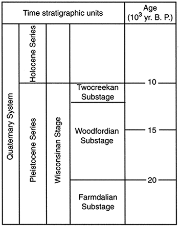
Figure 5--Late Quaternary chronology used in this study. Pleistocene-Holocene boundary after Hopkins (1975). Farmdalian, Woodfordian, and Twocreekan substages after Frye et al. (1965).
Although surface temperatures for the Woodfordian are relatively well understood, there is uncertainty regarding the levels of effective moisture. The majority of evidence suggests that the climate was relatively moist, at least compared to the Holocene. In particular, the floral record implies that levels of effective moisture were comparably high. Grass phytoliths derived from Peoria loess, exposed at the Eustis ash pit in south-central Nebraska, indicates deposition on a well-vegetated surface (Fredlund et al., 1985). According to Fredlund (1995), the pollen record at Cheyenne Bottoms, located in central Kansas, suggests a spruce parkland around 20,000 yr B.P. In the Arkansas River floodplain, near Wichita, remains (e.g., spruce wood and needles, cone fragments) of coniferous species were recovered in peat that dated to about 19,000 yr B.P. (Fredlund and Jaumann, 1987). Data from Harlan County Lake in south-central Nebraska, as well as Sanders's well in northeastern Kansas, indicate that uplands were populated by Populus (aspen) between 24,000 and 12,800 yr B.P. (Fredlund and Jaumann, 1987; Fredlund, 1989). Moreover, Wells and Stewart (1987) reported that Pinus flexilis (limber pine) and Picea cf. glauca (spruce) charcoal-dated to about 14,500 yr B.P. in south-central Nebraska.
Although some evidence indicates relatively high levels of effective moisture during the Woodfordian, other data point to increased aridity. In particular, Holliday (1987) argued that pollen data are misleading because spruce pollen is more resistant to weathering than other pollen taxa. Moreover, Holliday contended that buried soils of Woodfordian age should exhibit evidence of podzolization if conifers truly dominated. According to Feng (1991), no evidence for podzolization (e.g., spodic horizon) exists in the Peoria loess.
In addition to pollen and soils, some sedimentary evidence suggests that the glacial maximum was a period of increased aridity. During the Farmdalian, for example, uplands were very stable, with extended soil development in the Gilman Canyon Formation until around 22,000 yr B.P. (Fredlund et al., 1985; Johnson, 1993; Johnson et al., 1993). Subsequently, sedimentation of Peoria loess began, perhaps due to less effective moisture in the region (e.g., Johnson, 1993; Johnson et al., 1993). According to Johnson (1993), this hypothesis is supported by modelling of environmental conditions at the glacial maximum (e.g., Kutzbach and Wright, 1985, COHMAP Members, 1988; Crowley and North, 1991).
Evidence also points to increased late Wisconsinan aridity in south-central Kansas. Fredlund (1995) noted a major unconformity at Cheyenne Bottoms, one that spans the entire Woodfordian. He hypothesized that Cheyenne Bottoms was primarily a barren playa basin throughout the early Woodfordian, with both eolian deposition and erosion occurring. According to Fredlund, early Woodfordian aridity is not necessarily incompatible with the pollen record, which suggests the expansion of trees because limited taxa may have persisted. In fact, Fredlund argues that the Woodfordian may be subdivided on the basis of climate into an early Woodfordian, which was more xeric, and a more mesic late Woodfordian. The regional data are inconclusive. Wells and Stewart (1987) assign an early Woodfordian age to landsnail assemblages in Peoria loess. Leonard (1951, 1952) in contrast, correlates the same fauna with the late Woodfordian. Unfortunately, the record from Cheyenne Bottoms does not resolve the issue because the unconformity persists until the early Holocene (Fredlund, 1995).
Following the mesic environments of the Woodfordian, the transition to the Holocene was a period of major climatic and vegetational change across the central Great Plains. The driving mechanism behind this change were adjustments in the geometric relationship of the earth to the sun. Perhelion was in July, and this, in conjunction with a decrease in the earth's tilt (obliquity 24.23°), resulted in summer solar radiation at the top of the atmosphere that was about 8% greater than at present (Kutzbach, 1981, 1985, 1987). Given the increased radiation, the Laurentide ice sheet rapidly began to disintegrate (Andrews, 1987), promoting generally drier, zonal atmospheric flow (Knox, 1983). In south-central Kansas, these new atmospheric patterns caused a dramatic increase in Chenopodeaceae-Amarathanceae (Cheno-Am) populations soon after 11,000 yr B.P. in the basin at Cheyenne Bottoms (Fredlund, 1995). According to Fredlund, this increase reflects sharp fluctuations in water levels as the climate became more variable. At Muscotah Marsh in northeastern Kansas, Picea sharply declined around 12,000 yr B.P., concurrent with an increase in populations of Quercus, Ulmus, Fraxinus, and Salix. By the very end of the Woodfordian (~10,500 yr B.P.), Picea had completely been replaced by deciduous forest, which, in turn, was completely displaced by grassland by 9,000 yr B.P. (Gruger, 1973).
As the Laurentide ice sheet continued to waste during the early Holocene, the steep north-south temperature gradient which had been present during the Woodfordian further weakened, promoting further zonal flow (Knox, 1983). As a result, seasonal temperature extremes began to increase (COHMAP Members, 1988). Ultimately, these combined factors triggered the generally warm and dry conditions of the Altithermal (Antevs, 1955), which occurred from about 8,000 to 5,000 yr B.P. in central North America (Knox, 1983; Kutzbach, 1985, 1987; COHMAP Members, 1988; Crowley and North, 1991). By approximately 6,000 yr B.P., mean summer temperatures in the region were probably 2° to 4° higher than at present (COHMAP Members, 1988; Crowley and North, 1991), and annual precipitation was perhaps 25% less (Bartlein et al., 1984; Kutzbach, 1987). In Cheyenne Bottoms, Fredlund (1995) reported that water levels stabilized but were probably lower, depressing Cheno-Am populations.
Following the Altithermal, the climate of the central Great Plains was apparently more moist in the early part of the late Holocene. Evidence for this shift was reported at Muscotah Marsh in northeastern Kansas, where deciduous forest (e.g., Quercus, Carya) briefly repopulated portions of the landscape after 5,000 yr B.P. (Gruger, 1973). Since that time, however, the climate has apparently fluctuated between relatively moist and arid. According to Fredlund (1995), for example, high percentages of Cheno-Am pollen in late Holocene sediments in Cheyenne Bottoms indicate that water levels have varied, resulting in periodic drying of the basin in the past few thousand years.
Evolution of Dune Fields in the Central Great Plains
Arkansas River Valley of Kansas
Prior to the 1950's, geomorphic investigations of regional sand sheets were mostly qualitative in nature. In general, the research was speculative with regard to the chronology of events and associated climatic history because reliable age-determination methods (e.g., carbon-14, thermoluminescence) were not available. According to Ahlbrandt et al. (1983, p. 379), inferences were based upon correlations with loess or terrace-fill sequences and upon assumptions concerning strong katabatic winds during glacial periods. Much of the early research was conducted in Kansas, where interest focused on the dune fields along the Arkansas River valley.
In a general reconnaissance of southwestern Kansas, Hay (1893) thought the sand in the sand dunes along the Arkansas River was from a local bedrock source (e.g., the Ogallala Formation). Haworth (1897) conducted a study of the physiography of western Kansas, noting that the dune sand resembled valley sands along the river. In an overview of the geology of Kansas, Moore (1920) argued that the dune sand along the Arkansas River was derived from the floodplain, having been blown out to the south by northwesterly winds.
The most complete, early study of the physiography and geology of south-central Kansas was conducted by Courtier (1934). After observing that the prevailing winds during the early Dust Bowl years were southwesterly, Courtier assumed similar conditions existed when the dunes originally formed. As a result, he concluded that the residual soils from the local Dakota, Ogallala, and Sanborn Formations were the sand sources and not the Arkansas River to the north. Referring to the Great Bend Sand Prairie region specifically, he suggested the name "Great Bend sand plains" for the portion of the area covered by sand.
Additional paleoenvironmental evidence of dune age in Kansas was supplied by Smith (1938) from a small study near Hutchinson, Kansas. He observed three soil zones exposed in a blowout, which suggested at least three periods of "alternating sand movement and stabilization" (p. 115). Also exposed in the section were the fossil remains of Bison alieni, which confirmed a Pleistocene age for a least one of the units. According to Smith, strike and dip in a reddish-brown basal dune sand indicated northeasterly winds prevailed when the dune formed. The dune appeared to have been reworked by winds of varying directions, however, with modern blowouts resulting from southerly winds.
Smith (1939, 1940) argued that vegetation plays an important role in dune morphology on the Great Plains since pervasive dune forms (e.g., parabolic) suggest that true desert conditions have never prevailed. As a result, he concluded that sand dunes on the Great Plains evolve in two phases, eolian and eluvial. According to Smith, dunes grow during the eolian phase, when deflation removes sand from one part of the dune and deposits it nearby where vegetation is thick. In contrast, dune degradation occurs during the eluvial phase, when vegetation is sufficient to stop further erosion. As the eluvial phase progresses, dune contours are rounded by soil formation, creep and slope wash. Smith further argued that the cycle may be interrupted at any time and, in fact, that multiple cycles had probably occurred, giving most dunes in Kansas what he called a chaotic appearance.
Smith (1940) also considered the source of sand dunes in southwestern Kansas and prevailing paleowind directions. Since the dunes are not migratory in nature, he concluded the source for sand must be local, probably a combination of fluvial and outcropping bedrock origins. Interestingly, he thought that fluvial sources contributed to the smaller dune fields in the region, but that the Arkansas River was not the origin of sand for the massive dune field along its length because dunes were not presently moving across the floodplain. He acknowledged that the dune belt along the south side of the Arkansas River valley suggested that northwesterly winds had prevailed (implying a floodplain source) when the dunes formed. According to Smith (1940), however, dominant modern winds are southerly because transverse ridges near Syracuse, Kansas, face north.
The last substantative work of a qualitative nature about sand dunes in Kansas was done by Simonett (1960) in a study of dune development and stratigraphy along the Arkansas River near Garden City and Syracuse. At most localities, Simonett found Peoria loess underlying the dune sand, a relationship that indicated to him a northerly source for the sand because the loess crops out farther south. Moreover, lie recognized northerly dipping, lowangle backset beds in many dunes, further suggesting a northerly sand source. As a result, Simonett concluded that "Wisconsin alluvials from the Arkansas River" were the likely source for the dune sand and that most sand movement occurred during the Wisconsinan when northerly winds prevailed (1960, p. 223).
Simonett (1960) presented evidence, however, that recent dune-forming winds have been southerly. He agreed with Smith's (1940) interpretation that unvegetated transverse dunes and barchan dunes near Syracuse with steep, north-facing, slip faces indicate southerly winds. In addition, he recognized parabolic dunes nearby with arms that open upwind to the south. Simonett (1960) also discovered that the line of interdune depressions near Garden City runs southwest to northeast. Based on this combined evidence, he concluded that recent southerly winds have reworked dunes initially formed by northwesterly winds.
After a hiatus of about 30 years, new information regarding the origin and age of sand dunes in Kansas, specifically from the Great Bend Sand Prairie, has recently emerged. In a general study of late Quaternary stratigraphy of the region, Rosner (1988) concluded that surficial deposits of eolian sand overlie a poorly sorted silt-clay layer. Subsequently, Johnson (1991) referred to the silt-clay layer as the silt layer and determined that it was probably Peoria loess. Johnson obtained five radiocarbon ages, largely late Holocene in age, from the upper part of the silt layer where it was overlain by dune sand. As a result, he concluded that the ages represented intervals when the silt-layer was last exposed. In a review of the early descriptions of the Arkansas River valley by 19th-century explorers, Muhs and Holliday (1995) found evidence for both active and inactive sand in the area of the Great Bend Sand Prairie. At several localities, the presence of naked sand was noted in addition to tracts that were densely populated by sunflowers. In the western part of the region, near Pawnee County, the dunes were apparently more active, with large areas totally void of vegetation. This pattern of active and inactive dunes was described into Colorado, leading the authors to conclude that the degree of eolian sand mobilization along the Arkansas River in western Kansas varied spatially.
Despite the recent interest in the Great Bend Sand Prairie, the focus of research on Great Plains sand sheets in the past 30 years has clearly been in Texas, Colorado, and Nebraska. Moreover, geomorphic histories of dune fields in these areas are much more detailed and quantitatively based than those in Kansas. Palynological evidence, for example, has been used increasingly to determine local paleovegetation. In addition, age-determination techniques, specifically carbon-14, optical simulated luminescence (OSL), and thermoluminescence (TL), have been successfully used to establish chronologies of stability and instability within dunes.
Southern High Plains
Although data have begun to emerge regarding mobilization of eolian sand in Oklahoma (Brady, 1989; Olson et al., 1995), research south of Kansas has centered on the sand sheets and dune fields of the southern High Plains in the Texas panhandle. The earliest extensive work was conducted by Melton (1940), who classified the dune fields north of Lubbock into three series based upon their age. Reeves (1965) studied the lunettes surrounding the playas on the southern High Plains, concluding that they formed as playas deflated during dry interpluvials. Reeves obtained a radiocarbon age of approximately 19,000 yr B.P. for lacustrine strata beneath a dune on the southern margin of a playa, indicating that encroachment occurred during the Wisconsinan by northwesterly winds. He argued that dunes on the playa's northern and eastern margins had formed in the last 5,000 years due to strong, southerly winds.
The most extensive research on dune fields in the region has been conducted in the past 10 years around Lubbock Lake, Texas. Holliday (1985) excavated a lunette associated with Cone Playa and recognized seven stratigraphic units and five buried soils in the dune that yielded ages ranging from about 34,000 yr B.P. to 1,400 yr B.P. A detailed study of Holocene eolian sedimentation on the southern High Plains was reported by Holliday (1989). Using stratigraphic data from a variety of sites (e.g., Blackwater Draw, Yellowhouse Draw, Lubbock Lake), he reached the following conclusions: (1) eolian sedimentation in the region first occurred locally between about 10,000 yr B.P. and 9,000 yr B.P.; (2) eolian sedimentation was episodic but widespread from 9,000 yr B.P. to 5,500 yr B.P., with most areas affected by 6,500 yr B.P.; (3) eolian sedimentation occurred at all localities between 5,500 yr B.P. and 4,500 yr B.P.; and (4) landscapes have been stable for the past 4,500 years. Of particular importance, Holliday (1989) reported that two pulses of eolian sedimentation, separated by a brief period of soil formation, occurred during the middle Holocene: about 6,300 yr B.P. to 5,000 yr B.P. and 5,000 yr B.P. to 4,500 yr B.P. Using previous research (e.g., Wendorf and Hester, 1975; Johnson, 1986, 1987) and data on fossil gastropods collected from the Lubbock Lake site, Pierce (1987) reviewed the history of late Quaternary climate change on the southern High Plains. He argued that mean annual temperature increased from a low of 7.5°C during the late Wisconsinan to an Altithermal high of 20°C. During the late Holocene, increased precipitation, along with a decrease in mean annual temperature to about 175°C, temporarily re-established more mesic conditions in the region. According to Pierce (1987), climate has changed slightly to the present semi-arid conditions in the past 1,000 years.
The latest research from the southern High Plains was reported by Holliday (1995). Radiocarbon ages, soils, and archeological evidence indicate sedimentation in four phases during the past 11,000 years. In the latest Pleistocene, sand sheets accumulated in vegetated valleys and lake basins. The first widespread dune formation occurred between about 10,000 yr B.P. to 8,000 yr B.P. Evidence for middle Holocene eolian deposition exists in valley fills, but upland dunes were probably reworked in the later Holocene. The last phase of dune construction occurred in the past 3,000 years, with multiple episodes of stability characterized by buried soils with A/C or A/Bw profiles.
Northeastern Colorado
Abundant, detailed research has been conducted on the sand sheets and dune fields of northeastern Colorado, specifically the Hudson, Wray, and Fort Morgan dune fields. In a detailed study of these localities, Muhs (1985) classified dune types and determined their relative ages and source. According to Muhs, the pervasive dune type is parabolic with arms that point 30-40° west of north, indicating prevailing northwesterly winds and the South Platte River as a sand source. Muhs estimated the approximate age of the dunes by comparing surface soil development there with localities in Nebraska studied by Ahlbrandt and Fryberger (1980) and Ahlbrandt et al. (1983). He concluded that the soils, which are mostly Typic Ustipsamments with A/AC/C profiles, are similar in development. As a result, he inferred that the Wray and Fort Morgan dune fields formed at the same time as a major period of dune development in Nebraska (3,000- 1,500 yr B.P.), once thought by Ahlbrandt and Fryberger (1980) and Ahlbrandt et al. (1983) to correlate with the interstade between the Triple Lakes and Audubon glacial advances in the Front Range (Benedict, 1973).
Additional studies in northeastern Colorado have been reported by Forman and Maat (1990), Forman et al. (1992), and Madole (1994, 1995). Forman and Maat (1990) used soil morphology and age to conclude that reactivation of the Hudson dune field occurred sometime between 9,000 yr B.P. and 7,000 yr B.P. and that the dunes stabilized only in the past 3,000 years (Forman and Maat, 1990). Subsequently, Forman et al. (1992) analyzed the regional dunes through principal components analyses of Landsat Thematic Mapper (TM) imagery. In addition, the stratigraphic record from a 7-m (23-ft)-thick section of sheet sand near Hudson, Colorado, was described. Radiocarbon ages from four buried soils exposed in the section indicated that the sands at this locality have been reactivated at least four times during the Holocene: 9,500-5,500 yr B.P., 5,500-4,800 yr B.P., 4,800-1,000 yr B.P., and <1,000 yr B.P.
The most recent research from dune fields in northeastern Colorado was conducted by Madole (1994, 1995). Two buried soils were recognized in dunes at five, widely scattered localities along the South Platte River valley. Typically, the lower soil was better developed, with A/Bw/C horizonation, whereas the upper one was an A/C profile. Radiocarbon ages derived from the total humate fraction of the sola indicated that significant activation of eolian sand has occurred in the last 1,000 years, resulting in 3-4 m (10-13 ft) of sand accumulation. From the lower solum, radiocarbon ages of about 1,400, 1,200, and 900 yr B.P. were derived. In contrast, the upper soil yielded ages of approximately 1,000, 900, and 800 yr B.P. Values of δ13C ranged from -18.2‰ to -15.2‰ (parts per thousand), suggesting to Madole that plants with a C4 pathway (warm, dry-adapted) have inhabited the region in the past 1,000 years.
Nebraska Sand Hills
The most extensive, long-term study of sand dunes and sand sheets in the Great Plains has been conducted in the Sand Hills of Nebraska. The Sand Hills cover approximately 50,000 km2 (12,000 mi2), by far the most extensive area of eolian sand in the western hemisphere (Smith, 1965). Dunes are also much larger in the Sand Hills than elsewhere on the Great Plains. Individual barchan-ridge dunes, for example, may be as much as 40 km (130 ft) long and 150 m (490 ft) high. Average parabolic dune length and height is approximately 450 m (1,475 ft) and 20 m (65 ft), respectively (Swinehart, 1990). The Pliocene Ogallala Formation, either as in-situ deposits or reworked alluvial sediments, is thought to be the source of the dune sand (Lugn, 1935; Swinehart, 1990).
The age of the Sand Hills is controversial, with active debate about whether the dunes formed during the late Wisconsinan or Holocene. Early research suggested primary mobilization of sand during the late Wisconsinan in a periglacial environment. Watts and Wright (1966), for example, obtained a radiocarbon age of about 13,000 yr B.P. on organic sediments at the base of the core in an alluviated lowland between two large dunes at the Rosebud site. Palynological evidence from the core indicated that a boreal spruce (Picea cf. glauca) forest existed in the region about 13,000 yr B.P. that was soon replaced first by pine (Pinus ponderosa) and then by grassland. According to Bradbury (1980), the palynological data obtained by Watts and Wright (1966) placed several constraints on the time of eolian deposition in the Sand Hills. Bradbury argued that dunes were probably present before the boreal forest, but that dunes could not have formed during forest occupation of the region. Accordingly, he concluded that the last, major period of dune movement occurred after the forests left, most likely during the middle Holocene.
Ahlbrandt et al. (1983) suggested that ages obtained from interdunes by Watts and Wright (1966) and Bradbury (1980) are unreliable chronostratigraphic markers because their association with dune sand has not been positively established. Instead, Ahlbrandt et al. (1983) argued that the only reliable estimates of dune mobilization are those from material directly underlying eolian sand. They reported several radiocarbon ages, ranging from approximately 10,000 yr B.P. to 900 yr B.P., on organics buried by dune sand. Based on these ages, they recognized two distinct and one possible period of Holocene dune formation in the Sand Hills. Radiocarbon ages of about 7,200 yr B.P. and 5,100 yr B.P. bracket the Altithermal, suggesting the first episode of dune formation in the region. The best-documented phase of eolian activity is the period between approximately 3,000 yr B.P. and 1,500 yr B.P. Another, poorly documented, period of dune formation may have occurred in the latest Holocene, as indicated by a radiocarbon age of about 900 yr B.P. obtained from organic-rich sand underlying 8 m (26 ft) of dune sand.
In the most extensive report regarding the Sand Hills, An Atlas of the Sand Hills, Swinehart (1990) included a detailed map of the region that illustrates the distribution of eight dune types, based on McKee's (1979) classification system. Swinehart also reported a radiocarbon age of 13,160 ± 450 yr B.P. obtained from organics buried beneath 50 m (164 ft) of dune sand and 3 m (10 ft) of alluvial sand. In general, Swinehart (1990) concluded that the Sand Hills most likely formed between 8,000 yr B.P. and 5,000 yr B.P. Following about 2,000 years of stabilization, significant reactivation occurred between 3,500 yr B.P. and 1,500 yr B.P. when linear and parabolic dunes developed in areas previously not covered with sand and on preexisting dune topography.
Since Swinehart's (1990) study, additional data have emerged, confirming substantial, late-Holocene mobilization of the Sand Hills. Based on radiocarbon ages derived from interdune fens, Ponte et al. (1994) hypothesized two episodes of eolian activity in the Nebraska Sand Hills during the late Holocene: from 3,500 yr B.P. to 2,800 yr B.P and after 1,000 yr B.P. In addition, Muhs et al. (1995) reported 17 new radiocarbon ages that showed dune mobilization in the past 1,000 years.
Clearly, much research has been conducted in Great Plains sand sheets and dunes this century. The earliest work (1920's-1960's) focused on the dune fields of Kansas, but was qualitative in nature and lacked absolute age control. Conclusions were based upon loess or terrace-fill sequences and oversimplified glacial chronologies. Generally, dunes along the Arkansas River valley were thought to have formed during the late Wisconsinan, when strong winds theoretically blew off of the Laurentide ice sheet to the north. In fact, the primary evidence of a late Wisconsinan age for the dunes was their position on the southern side of the river which, hypothetically, would have occurred only as a result of persistent northerly winds.
Detailed chronologies and associated climatic histories have been constructed for a variety of sand sheets and dune fields on the Great Plains since the advent of the radiocarbon dating technique in the 1950's. Rather than a late Wisconsinan age for most dunes, results indicate that many dunes may have initially formed during the Holocene Altithermal (9,000-6,000 yr B.P.) but have been destabilized episodically since. Periods of stability have often been brief, resulting in soils with A/AC/C profiles. In addition, instability appears to have varied spatially in dune fields, with some places active and others not. Prevailing winds were northwesterly in the Sand Hills and in Colorado and southwesterly on the southern High Plains.
Significance of Previous Research to this Study
The review of relevant literature revealed several research questions, specifically germaine to the Great Bend Sand Prairie, which were the hypothetical foundation of this study. With regard to the climate history of the region, it was believed that evidence would show a change from cool and moist during the late Wisconsinan to relatively warm and dry in the Holocene. From a stratigraphic perspective, Rosner (1988) recognized a near surface silt-clay layer that, she claimed, underlies most dunes in the study area. Johnson (1991) referred to the unit as a silt layer that, he argued, is probably Peoria loess and therefore late Wisconsinan in age. Given the overall lack of data regarding this relatively fine-textured deposit, one goal of this study was to test the following hypotheses: (1) the deposit is indeed commonly occurring, (2) the unit provides a maximum-limiting age for dune development, and (3) the deposit is Peoria loess.
Several questions also arose that focus on the age of dunes on the Great Bend Sand Prairie, the chronology of eolian activity, and the variables that caused eolian sand to initially mobilize and subsequently remobilize. Numerous studies (e.g., Antevs, 1955; Gile, 1979; Ahlbrandt et al., 1983; Muhs, 1985; COHMAP Members, 1988; Holliday, 1989) indicate that a climate shift from cool conditions with more effective moisture to a warm, semiarid and subhumid climatic regime occurred at the PleistoceneHolocene boundary on the Great Plains. This shift in climate is thought to have favored dune formation in northeastern Colorado (Muhs, 1985), Nebraska (Ahlbrandt et al., 1983), and in the southern High Plains (Holliday, 1985, 1989). Moreover, the data clearly indicate that dunes have episodically mobilized throughout the region. Given these findings, the ultimate goal of this study was to test the following hypotheses: (1) dune fields on the Great Bend Sand Prairie are generally Holocene landforms, (2) mobilization of eolian sand occurred because the climate shifted from cool and relatively moist in the late Wisconsinan to semiarid and subhumid during the Holocene, and (3) Holocene mobilization of sand has been episodic and patchy.
Research Methods
Data Requirements
Given the lack of geomorphic information that previously existed from the Great Bend Sand Prairie, data were collected in this study using standard field and laboratory methods. Several sources of existing data proved to be useful in the early stages of the study, including bulletins and reports of the Kansas Geological Survey and soil surveys published by the U.S. Department of Agriculture Soil Conservation Service (SCS). In addition, landscape data were derived from U.S. Geological Survey 7.5-minute topographic maps and 1:24,000-scale stereographic aerial photography supplied by the Kansas Applied Remote Sensing Program (KARS).
Field and Laboratory Methods
The field investigation began with exploration of the study area. During this phase, sand-sheet landforms were categorized and mapped according to McKee (1979) through a combination of aerial photograph analysis and field survey. A major goal of the reconnaissance was to better understand the spatial distribution of Rosner's (1988) silt-clay layer and Johnson's silt layer (1991). Accordingly, sub-dune stratigraphy was explored at 126 widely scattered and randomly selected sites throughout the region with a Giddings coring machine and hand bucket auger. Test depth varied considerably, ranging from about 2.5 m (8 ft) to around 30 cm (1 ft), depending upon the depth of the deposit. Given the inherent imprecision associated with bucket augering, stratigraphy and texture were only generally described. Basic characteristics (e.g., texture, color, structure) were noted qualitatively, with the primary goals being to determine whether the deposit was present at a given site, to ascertain the thickness of overlying wind-blown deposits, and to select sites for more intensive stratigraphic study.
Based upon the exploratory results, 24 sites were selected and investigated in more detail. Of those, five sites were quarries, roadcuts, or stream cutbanks where radiocarbon ages were derived but no sampling for chemical and physical attributes of sediments occurred. Nineteen sites were selected for detailed stratigraphic investigations where backhoe trenches were subsequently excavated, either to provide a fresh exposure or to accentuate an already existing cutbank, quarry, or drainage trench. At each of these sites, pedostratigraphic units were differentiated according to the North American Stratigraphic Code (The North American Commission on Stratigraphic Nomenclature, 1983) and pedologic horizons were described according to Soil Conservation Service standards (Soil Survey Staff, 1987).
Various laboratory procedures were employed to characterize the physical and chemical composition of pedostratigraphic units. Differences in sediment texture were quantified by the pipette method (Day, 1965). In order to graphically plot textural results, Krumbein's (1934) logarithmic transformation (phi scale) of the Udden-Wentworth (Wentworth, 1922) grade scale was used. Subsequent graphical statistics, including the mean, median, sorting, skewness, and kurtosis (as defined by Folk and Ward, 1957) were calculated with software by Prante (1989). To better characterize the depositional environments in which the silty sand and dune sand accumulated, scatterplot analyses of textural variables (e.g., Folk and Ward, 1957; Friedman, 1967) were conducted on a total of 140 samples that were collected from the twelve sites at which both the silty sand and dune sand were well expressed.
Chemical characterization of late Quaternary sediments focused on calcium carbonate and organic matter analyses. Carbonate content in sand dunes was expected to be minimal, except where buried soils were present, because eolian sands are relatively porous and very well drained. In contrast, carbonate content in the silty deposits was expected to be relatively high, owing to low infiltratibility and the accumulation of illuvial calcium at an unknown depth in a cool, relatively moist climate. Accordingly, the Chittick method (Dreimanis, 1962) was used to quantify calcium-carbonate concentrations. Similarly, the Walkley-Black method (Allison, 1965) was used to determine the organic-matter content in sediments, to better define soil A horizons, and to test for 14C-dating potential.
The chronology of deposition and stability was reconstructed from radiocarbon ages obtained from the total humate fraction of bulk samples (>4 kg; 9 lb) collected from the upper and lower 5 cm (2 in) of buried A horizons. Radiocarbon ages from the lower parts of buried A horizons provide the closest minimum-limiting ages for the host deposit, whereas those from the upper parts of buried A horizons give the closest maximum-limiting ages for overlying units. Rootlets and other detrital plant material were removed by flotation, the sand fraction was separated by decantation, and carbonates were eliminated by treatment with hydrochloric acid. Samples were subsequently oven dried, pulverized, and sent to the University of Texas (Austin) for age determination. In order to provide conservative radiocarbon estimates, all ages were calculated at 2σ, corrected for isotopic (δ13C) fractionation (Stuiver and Polach, 1977) and calibrated to the tree-ring curve (Stuiver and Reimer, 1993).
In an effort to fully characterize paleoenvironmental conditions in the region, faunal and floral remains were collected at three sites and were subsequently identified in The University of Kansas soil laboratory. Additional paleofloral evidence was provided from δ13C values obtained from buried soils in the silty deposits and dune sand. It has been established that δ13C values can be used to infer vegetation and associated paleoclimate (e.g., Krishnamurthy et al., 1982; Delaune, 1986) at the time of soil formation or deposition because many warm-climate (C4) prairie grasses (e.g., Andropogon gerardii, Panicum virgatum) typically have mean δ13C values of -12‰ whereas cool-climate (C3) prairie grasses (e.g., Elymus canadensis, Agropyron smithii) have average δ13C values of -27‰ (Deines, 1980; Krishnamurthy et al., 1982; Cerling and Quade, 1993; Nordt et al., 1994). Buried soils in silty deposits, for example, were expected to have more negative δ13C values than those obtained from buried soils in dune sand, reflecting a climate shift from cool and relatively moist to warmer and semiarid to subhumid.
Prev Page--Introduction and Study Area || Next Page--Results
Kansas Geological Survey, Geology
Placed on web March 16, 2016; originally published 1998.
Comments to webadmin@kgs.ku.edu
The URL for this page is http://www.kgs.ku.edu/Publications/Bulletins/242/03_resear.html