Previous--Damme Field, Finney County || Next--Coats South Area, Barber County
1Canyon Energy, Inc., 2Geographix, and 3Consulting Geologist
This article available as an Acrobat PDF file (10 Mb).
Stockholm SW field was the first Morrow oil field discovered in what is referred to as the Stateline trend. This 30-mi (48-km) trend is located along the border between Kansas and Colorado and includes western Wallace and Greeley counties, Kansas, and eastern Cheyenne and Kiowa counties, Colorado. Oil is produced out of Lower Pennsylvanian Morrow valley-fill sandstones from more than 250 producing wells comprising 10 fields.
While not utilized in the original discovery of Stockholm SW field, geophysics has played a significant role in the exploration for and development of all subsequent fields in the trend. The incisement of valleys into the underlying carbonates has created a thick Morrow sequence directly mappable with modem seismic techniques. Hundreds of miles of seismic data have been acquired along the Stateline trend in the exploration for Morrow reservoirs, and 3D seismic has proved valuable in field development. Aeromagnetic data provide clues as to the basement influence on Morrow drainage patterns. The use of these data and the key geologic elements of the play are the focus of this paper.
Stockholm Southwest (SW) field is located in T. 15 and 16 S., R. 42 and 43 W. of Greeley and Wallace counties, Kansas, and in T. 16 S., R. 41 W. of Cheyenne County, Colorado. The field is part of a major oil-producing trend which lies on a regionally stable Paleozoic platform which developed in the northern reaches of the Hugoton embayment of the evolving Anadarko basin (fig. 1). This trend lies east of the prominent Las Animas Arch and extends for 30 mi (48.3 km) north and south of Stockholm SW field, straddling the Colorado/Kansas border. It has been informally named the Stateline trend and consists of 10 oil fields, all of which produce from a sequence of Lower Pennsylvanian Morrow fluvial valley-fill sandstones. Stockholm SW was the first oil field discovered in this trend. Other fields in the Stateline trend include Harper Ranch, North Arapahoe, Arapahoe, Arapahoekan, Frontera, Second Wind, Jace, Moore-Johnson, and Sidney.
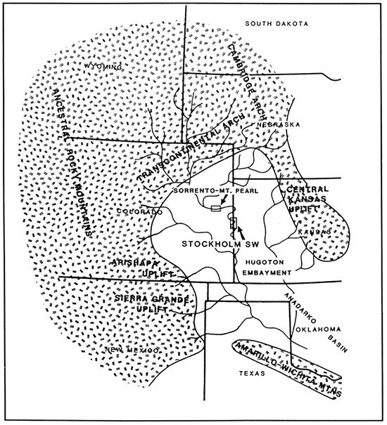
Figure 1--Morrow paleogeography map. This figure shows areas of crystalline basement uplift, hypothetical Morrow drainage systems, the Hugoton embayment, and the Anadarko basin as they are postulated to have appeared during Morrow time. It also serves as a regional index map for this paper (modified after Swanson, 1979).
The primary pay at Stockholm SW field is the Stockholm sandstone, which is stratigraphically the lowest sandstone in the upper Morrow Series at Stockholm SW. The Johannes sandstone, found stratigraphically immediately above the Stockholm sandstone, is a secondary pay at Stockholm SW.
Prior to the 1970's, all of the Morrow production in southeast Colorado, excluding southeast Baca County, was gas with associated condensate. In 1971, Koch Exploration Company completed the first Morrow oil well in the area at Smoky Hill field in Kit Carson County, Colorado. The well proved to be noncommercial and did not attract much industry attention. In the middle to late 1970's, Texas Oil and Gas Production Corp. (TXO) began a detailed examination of petrophysical well logs in southeast Colorado and western Kansas, looking for possible by-passed productive zones. As part of this exploration effort, TXO drilled the Evans No. 1 "E" in December 1978, a twin to the R.G. Smith-Evans No. 1, a dry hole located in the NE NE SE sec. 11, T. 16 S., R. 43 W., of Greeley County, Kansas. The original Evans No. 1 was drilled and abandoned in 1969, and no cores or drill-stem tests were taken. This well penetrated 27 ft (8.2 m) of Stockholm sandstone with no shows of oil reported in the samples. In the twin to the dry hole, the TXO wellsite geologist logged oil shows in the Stockholm sandstone, which was drill-stem tested and recovered 550 ft (167.8 m) of oil and gas, 1,000 ft (305 m) of mud-cut oil, 500 ft (152.5 m) of oil and mud, and 100 ft (30.5 m) of oil and water. In March 1979, the well was completed in the Stockholm sandstone for an IPP of 82 BOPD and 528 MCFGPD.
The TXO-Evans No. 1 "E" became the first commercial Morrow oil well in the entire southeast Colorado and immediate stateline area north of T. 24 S. Previously, Morrow sandstones in the area had only produced low-BTU gas. Soon after the discovery of the Stockholm SW field, oil production was established in the Sorrento field 50 mi (80 km) to the west of Stockholm SW field (fig. 1).
The initial development of the Stockholm SW field proceeded in an east-west direction from the discovery well. The pace of development slowed as dry holes were encountered at the eastern and western margins of the field, which suggested a lack of further sandstone deposition. In July 1985, TXO drilled the Bergquist No. 1 in the SW SW NE sec 6, T. 16 S., R. 42 W., of Greeley County, Kansas, a northeast stepout to Stockholm SW of over 1/2 mi (0.8 km). This well initially flowed 800 BOPD and was significant in that it showed a dramatic northward turn of the Stockholm sandstone trend and suggested that Stockholm SW drained a much larger area than originally thought. The pace of development proceeded quickly after the successful completion of the Bergquist No. 1. The TXO-Wallace No. 1 "R," drilled in March 1987 in the C W/2 sec. 29, T. 15 S., R. 42 W., of Wallace County, Kansas, was another stepout to the north and was significant in that it was drilled solely on the basis of seismic information. Seismic data would prove instrumental in the subsequent development and exploration in the trend.
Three significant wildcats drilled in 1987 would cause activity in the trend to expand dramatically to the north of the Stockholm SW field. The Medallion-Arapahoe No. 27-1 was drilled in the SE NW sec. 27, T. 15 S., R. 42 W., of Cheyenne County, Colorado, and completed as a Stockholm sandstone oil well. It rejuvenated the Arapahoe field originally discovered by TXO in April 1978, a field that was producing low-BTU gas and oil from the Johannes sandstone. The Frontera field was discovered with the drilling of the Mull-Stateline Ranch No. 1 in the NW NW sec. 18, T. 15 S., R. 41 W., of Cheyenne County, Colorado. A short time later, TXO drilled the discovery well of the Arapahoekan field, the Hibbert No. 1 "A" in the NE NW NW sec. 1, T. 15 S., R. 43 W., of Wallace County, Kansas.
Production to the south of the Stockholm SW field was first initiated with the discovery of the Second Wind field in July 1988. The discovery well, the TXO-Kriss No. 1 "A," was drilled in the NE NW sec. 18, T. 16 S., R. 41 W., of Cheyenne County, Colorado, and completed as a Stockholm sandstone oil well. The Stateline trend currently comprises 10 fields over an area extending from T. 12 S., R. 43 W., of Cheyenne County, Colorado, to T. 18 S., R. 43 W., of Greeley County, Kansas.
The sandstones of the Stockholm SW field were deposited during a time of relatively minor structural activity in the immediate area. Major paleogeographic features during Morrowan time were the Transcontinental Arch to the north, the Central Kansas uplift to the east, the Ancestral Rocky Mountains to the west, and the still developing Anadarko basin to the extreme south. This structural setting created the regional northwest to southeast drainage into the Anadarko observed during Morrowan time (fig. 1).
Geophysical data indicate a high degree of faulting and fracturing in the underlying Mississippian carbonates which appear to be basement seated. The pre-Morrowan structural activity developed a conjugate framework of fault and fracture trends oriented northeast and northwest across the Stateline trend. These northeast and northwest trends are evident throughout the Rocky Mountain region and are believed to be related to regional wrench-fault tectonics (Stone, 1968). Although significant structural activity along these trends appears to have ceased during Morrowan time, subtle expressions of these trends seem to have influenced the direction of Morrow drainage in local areas. Specifically, the pronounced westward bend of the Stockholm SW field into T. 16 S., R. 43 W., is postulated to have been the result of the Morrow channel system encountering a low-relief escarpment feature (fig. 2).
Figure 2--Structure map, top Morrow formation.
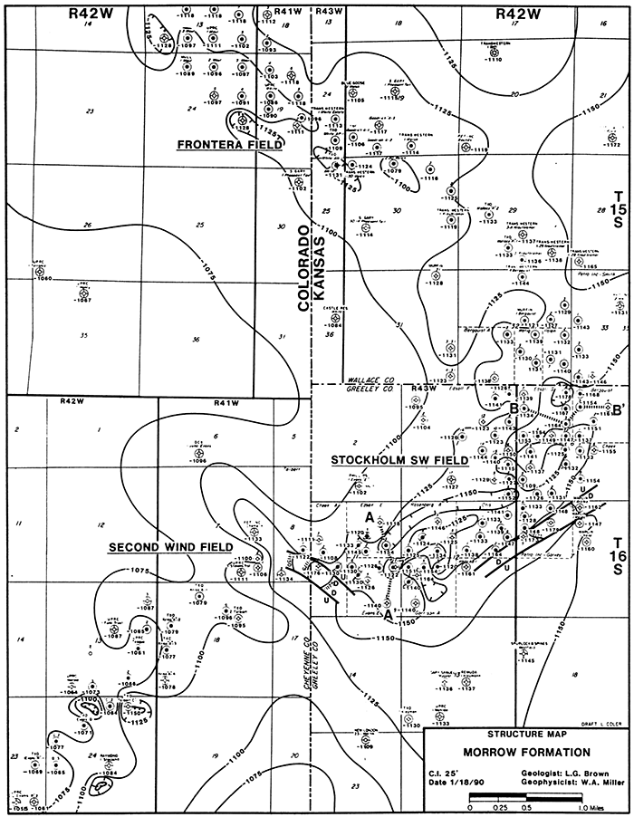
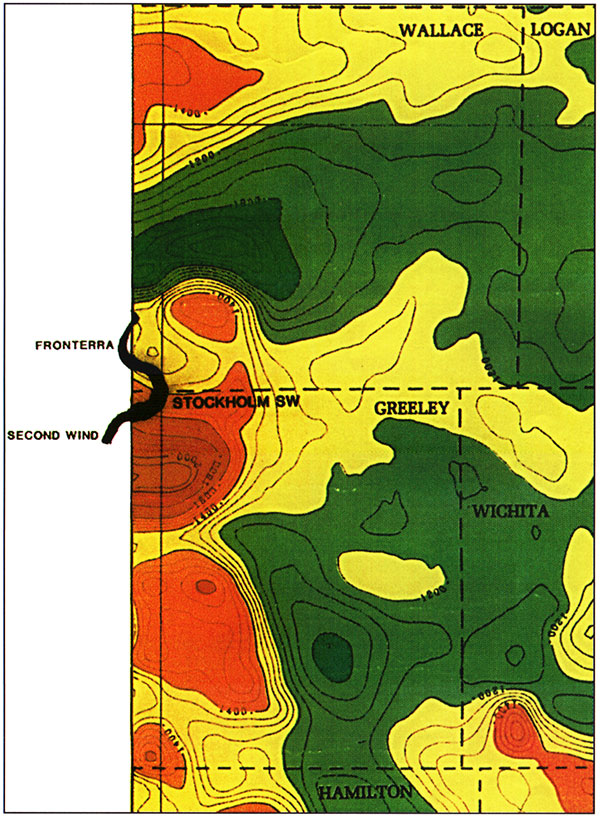
Post-Morrowan structural activity appears to have reactivated some of the pre-existing fault trends. The most significant reactivation appears to have occurred during the Laramide Orogeny. The south side of the Stockholm SW field is bounded by post-Morrowan faults which are parallel to, but not coincident with, the thick Morrow section and suggest rejuvenation of a fault framework that had previously influenced drainage during Morrowan time (fig. 2). The sense of the movement, however, appears to have reversed from pre-Morrowan to post-Morrowan time, perhaps due to a subsequent change in the orientation of the regional stress field. A lack of consistent deep log data has made an accurate reconstruction of this timing difficult. Regional aeromagnetic data indicate that the Stockholm SW field is positioned near a dramatic intrabasement compositional contact, a probable zone of weakness during tectonic activity (fig. 3).
Figure 3--Portion of the Kansas aeromagnetic map in the Stockholm SW field area (after Yarger et al., 1981).
Stockholm SW field is located on a regionally west-to-east tilted surface which developed as a result of movement during the Laramide Orogeny. The regional Stockholm sandstone trend is parallel to structural strike as defined by mapping the structure on the top of the Morrow Formation. A significant aspect of structure in the Stockholm SW field and along the Stateline trend is the occurrence of local structural depressions which often contain wet, nonproductive sandstone. Seismic data have shown these to be fault related. Development 3D seismic to the southwest of Stockholm SW field in the Second Wind field suggests that, in some instances, these faults led to the creation of collapse features in the Mississippian as small as 20 acres (8.1 ha) in areal extent (fig. 2). These features, which are post-Morrowan in occurrence, can display as much as 100 ft (30.5 m) of relief. Recognition and avoidance of these structural features is important in field development.
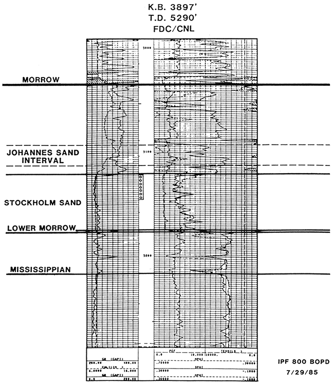
The Morrow Formation in the Stockholm SW field is subdivided into the sandstone, siltstone, and shale of the upper Morrow and the carbonate and shale of the lower Morrow. All of the oil and gas production in the Stockholm SW field is from upper Morrow sandstones. The primary hydrocarbon reservoir is the Stockholm sandstone, with additional hydrocarbon reservoirs occurring in the Johannes and other overlying sandstones (fig. 4). The Morrow is underlain by Mississippian carbonates and overlain by carbonates and shales of the Pennsylvanian Atoka formation.
Figure 4--Type log, TXO-Bergquist No. 1, SW SW NE sec. 6, T. 16 S., R. 42 W., Greeley County, Kansas.
Regionally, the Stockholm SW field is situated on a stable Paleozoic platform which extended north from the Anadarko basin. The older Mississippian formations sequentially subcrop to the north with increasing distance from the Anadarko basin. In the Stockholm SW area, the Ste. Genevieve limestone is the youngest Mississippian formation present. It is a slightly arenaceous, cream to tan, micro-oolitic wackestone. The Ste. Genevieve is very thin at Stockholm SW and near its subcrop limit. Consequently, the St. Louis limestone is more often the Mississippian formation penetrated. The St. Louis is a massive, very dense, tight, dark-gray crinoidal wackestone. The lower Morrow limestone rests unconformably on top of the Mississippian at Stockholm SW field and is deposited on the topography developed on this unconformity. The lower Morrow limestone is a very tight, argillaceous, glauconitic, crinoidal wackestone which is typically interbedded with thin marine shales. Regionally, the lower Morrow section thickens dramatically to the south into southwest Kansas and the Anadarko basin (Swanson, 1979). The top of the lower Morrow is overlain unconformably by the upper Morrow, and this erosional surface can create deep channel incisements into the lower Morrow. At Stockholm SW, the lower Morrow thickness ranges from 0 to 70 ft (0-21.4 m) and varies as a function of both unconformities.
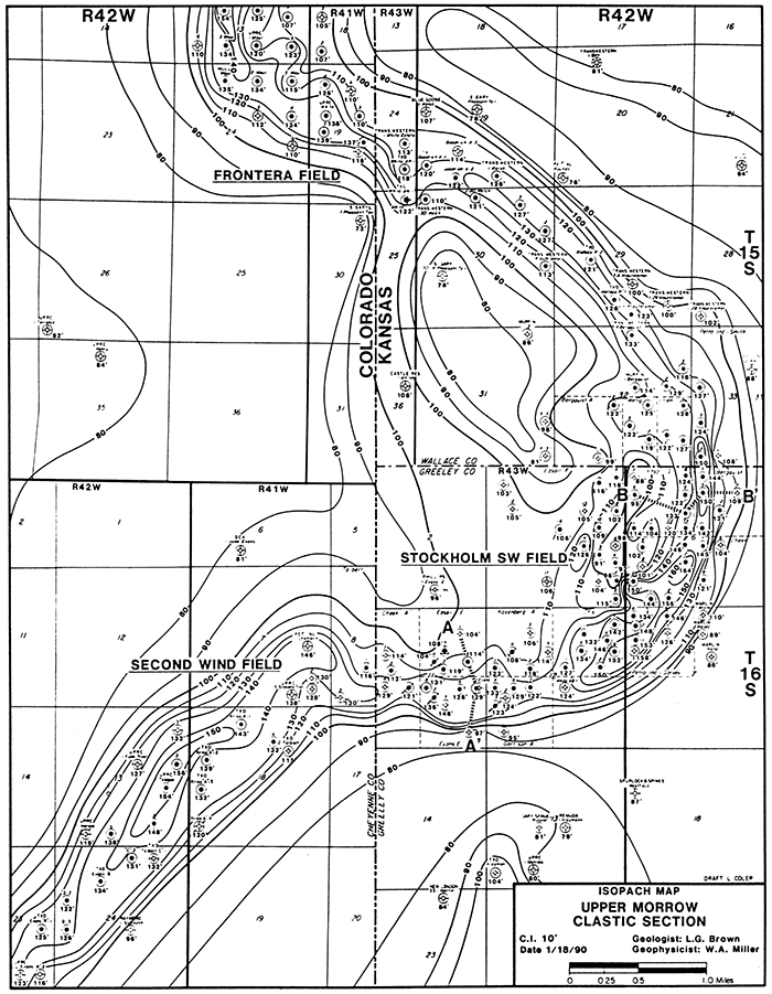
The upper Morrow section in the vicinity of the Stockholm SW field consists predominantly of marine and nonmarine clastic rocks with an occasionally isolated thin, lenticular limestone bed. Average thickness of the upper Morrow is approximately 85 ft (25.9 m) in this area. Paleontological data from the upper Morrow indicate a depositional environment which ranged from shallow, open and restricted marine shelf to estuarine. The late Morrowan Anadarko sea experienced numerous episodic fluctuations in sea level which were related to global glacial events documented in the Pennsylvanian (Vail, 1977). When the Anadarko sea withdrew during a regressive phase, the Morrowan shelf sediments were subaerially exposed. Upper Morrowan fluvial systems subsequently flowed out across these exposed mud flats enroute to the Anadarko basin. The Stockholm fluvial system created a deep incisement, or valley, into the lower Morrow limestone. In portions of the field, the lower Morrow limestone has been completely eroded and the Stockholm sandstone lies unconformably on the Mississippian. The Stockholm SW valley was subsequently back-filled with fluvial and estuarine sediments during a transgression of the Anadarko sea. The upper Morrow is up to 150 ft (45.8 m) thick in the areas of the erosional valleys (fig. 5). The Stockholm SW valley-fill system is approximately 0.5 mi (0.8 km) in width, gently meandering and non-avulving, and it experienced virtually continuous sand sedimentation along its thalweg.
Figure 5--Isopach map, upper Morrow section.
The primary producing sandstone at Stockholm SW occurs at the base of the upper Morrow clastic section approximately 100 ft (30.5 m) below the top of the Morrow and is locally referred to as the Stockholm sandstone (figs. 6 and 7). The Stockholm sandstone is a fine- to coarse-grained quartz arenite and, in part, a gravel-sized conglomerate. It consists of multiple fining-upward sequences but tends to be coarsest at the base. The Stockholm sandstone reservoir consists of stacked sequences of fluvial pointbars and massive sandstones up to 61 ft (18.6 m) thick, which accumulated under estuarine conditions during marine transgressive periods.
Figure 6--Stratigraphic cross section A-A'. Datum is the top of the Morrow Formation. Note channel incisement into underlying lower Morrow carbonates.
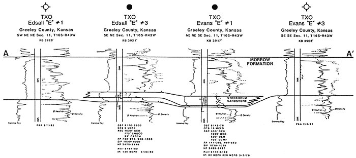
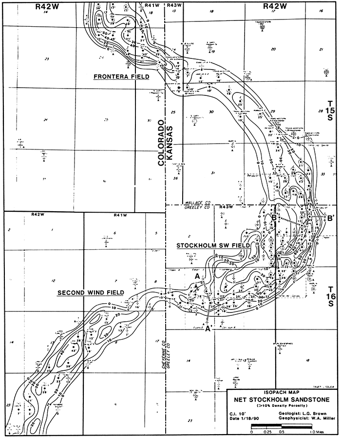
Figure 7--Isopach map, net Stockholm sandstone (density porosity greater than 10%).
Younger fluvial systems, active during post-Stockholm regressive pulses, tend to sub-parallel the pre-established Stockholm valley-fill system. These younger systems deposited the Johannes sandstone and other upper Morrow sandstones. The top of the Johannes sandstone is typically separated from the Stockholm sandstone by approximately 35 ft (10.8 m; fig. 4); however, in some areas of the field the Johannes sandstone lies in contact with the Stockholm sandstone. The Johannes consists predominantly of a series of discrete overlapping point-bars.
The Stockholm SW reservoir was initially interpreted as a marine-bar sandstone. The ubiquitous glauconite present coupled with coarsening-upwards log profiles was misleading to early geologic modeling and exploration. The key to exploration for the Stockholm sandstone was the recognition that it was related to a deeply incised valley-fill system. Various sandstone units in the upper Morrow section must therefore be correlated down from the top of the upper Morrow shale, or any other consistent regional marker in the upper Morrow section, rather than up from the top of the lower Morrow limestone (fig. 6). Employment of this model has greatly enhanced the ability of the explorationist to accurately explore for and develop this trend. After lying virtually dormant for approximately eight years, exploration and development along the Stateline trend greatly accelerated as a depositional model of the Stockholm sandstone integrated with the use of seismic data began to be understood and used effectively. Wildcat drilling extended the trend approximately 30 mi (48.3 km) with the discovery of several major fields both to the north and to the south.
A key element in the exploration for, and the development of, Stockholm sandstone-type reservoirs relates to identifying and staying within the confines of the thick sequence of upper Morrow encountered in the areas of valley-fill sedimentation. An isopach from the top of the Morrow shale to the lower Morrow limestone is a critical map in predicting the occurrence and distribution of the Stockholm sandstone (fig. 5). In the Stockholm SW field, almost all of the Stockholm sandstone development is observed to be within a thick sequence defined by this isopach (fig. 7). The additional standard techniques of structural and isopach mapping also are very important.
The Johannes sandstone deposition, while generally parallel to, or coincident with, the thick sequences of upper Morrow containing Stockholm sandstones, is not as readily predicted by this isopach-mapping technique. The general lack of continuity of the Johannes sandstone reservoirs makes them a more difficult exploration target. The general exploration techniques employed for Johannes exploration involve detailed isopach and structural mapping.
Though not used in the initial discovery of the Stockholm SW field, seismic methods have played an increasingly important role in the exploration for, and development of, the Morrow in the Stateline trend. The primary benefit of the use of seismic has been its ability to map the erosional valleys in which the Stockholm sandstone occurs. To illustrate this seismic signature, a seismic model generated from sonic log traces was constructed. Figure 8 shows an idealized sonic-log input model across the erosional valley system at Stockholm field. This input model was convolved with a zero-phase 10-15-70-80 Hz bandpass wavelet to generate the seismic-traces model response (fig. 9).
Figure 8--Idealized Morrow channel sonic log cross section for input into seismic trace model of fig. 9, flattened on the Morrow shale. Only lower portion of section is shown to focus on the Morrow interval.
Figure 9--Idealized Morrow channel seismic trace model generated from the input log section of fig. 8 by convolving with a 10-15-70-80 Hz zero-phase wavelet.
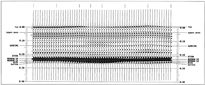
The primary contrasts in acoustic impedance that contribute the most to the seismic event are the change from carbonate to shale at the top of the Morrow, and the change from shale or sandstone to carbonate at the top of the lower Morrow limestone, or base of the upper Morrow. The Morrow shale is observed on the seismic model to be a left-deflecting trough while the top of the lower Morrow limestone is a right-deflecting peak. As the upper Morrow section thickens from less than 100 ft (30.5 m) on the flanks of the erosional valley to almost 150 ft (45.8 m) in the valley, the Morrow shale and limestone seismic reflectors diverge to the point where a "doublet" event forms over the thickest part of the Morrow channel. As the channel event begins to thin gradually on the flanks of the valley, this doublet event converges back to a single event.
The primary emphasis of mapping the valleys with seismic data has been the recognition of the "doublet" anomaly, or the actual time thickening of the Morrow section. The model illustrates one of the pitfalls in this interpretation of the "doublet" which is related to the nature of the lower Morrow limestone section. On the left portion of the model response (fig. 9), the peak at the lower Morrow limestone surface is a single event with little response immediately underneath. As the lower Morrow limestone occurs directly on top of the Mississippian carbonates, the net seismic effect is a massive combined carbonate section with the only reflecting interface being its top. The right-hand portion of the model shows a somewhat different response, and here the peak representing the top of the lower Morrow limestone is immediately followed by another peak event. This "peak-peak" response occurs where significant shale breaks develop either within the lower Morrow limestone section or at the Mississippian unconformity. Thus, the second peak creates a "doublet" appearance which in this case is not related to true thickening of the Morrow clastic section in a valley. One method of discriminating between the two signatures is to pay careful attention to the relative amplitudes of the top and bottom peaks comprising the "doublet." Experience has shown, and the model illustrates, that typically a true valley response will display more amplitude on the lower peak of the "doublet," while a "doublet" anomaly due to shale breaks below the top of the lower Morrow limestone often has more amplitude on the top peak of the "doublet." This analysis requires the data be as close to zero-phase as possible, and that all data used in the interpretation be phase-matched with a great deal of care.
A portion of actual seismic data across a Morrow channel is displayed at approximately the same scale as the model (fig. 10). There is very good agreement between the predicted model response and the actual response observed from the data.
Figure 10--Actual seismic data example over a known Morrow channel, plotted to the same scale as the model in fig. 9 for comparison.
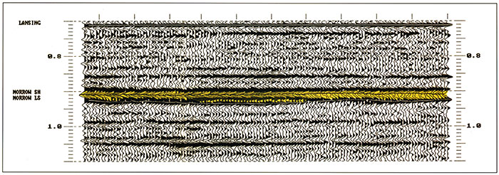
Figure 11 is a portion of an east-west CDP-vibroseis seismic line through the Stockholm SW field in sec. 6, T. 16 S., R. 42 W., Greeley County, Kansas. The approximate location of the data in fig. 11 is indicated by cross section B-B' on the Morrow isopach (fig 5). These 30-fold data were acquired with 120-channel recording using a group interval of 82.5 ft (25 m) and a source interval of 165 ft (50 m).
Figure 11--East-west seismic line across Stockholm SW field through the north half of sec. 6, T. 16 S., R. 42 W. and sec. 1, T. 16 S., R. 43 W. (Exact shotpoint locations not shown at owner's request.)
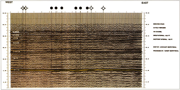
The deep incisement of the Stockholm erosional valley is apparent even at the display scale of these data. The three oil wells at the center of the section penetrated the Stockholm valley and produce from the Stockholm sandstone. The three oil wells just to the west produce from the Johannes sandstone on the flank of the main valley in a thinner upper Morrow clastic section.
A portion of the seismic data of fig. 11 was expanded to show the detailed seismic signature of the Stockholm erosional valley (fig. 12). A cross section of gamma-ray curves from the wells which tie these seismic data is shown to illustrate the change in thickness of the upper Morrow and its impact on the seismic response. As pointed out in the model discussion, the primary contrasts in acoustic impedance that contribute the most to the seismic event are the change from carbonate to shale at the top of the Morrow, and the change from shale or sandstone to carbonate at the top of the lower Morrow limestone, or base of the upper Morrow. The Morrow shale is observed on the seismic data to be a left-deflecting trough while the top of the lower Morrow limestone is a right-deflecting peak. As the upper Morrow section thickens from less than 100 ft (30.5 m) in the Edsall "G" No. 6 well to almost 150 ft (45.8 m) in the Bergquist No. 5 well, the Morrow shale and limestone seismic reflectors diverge to the point where a "doublet" event forms over the thickest part of the Morrow channel. As the channel event begins to thin gradually into the Bergquist No.4 well, the doublet event converges back to a single event.
Figure 12--Composite stratigraphic/seismic cross section B-B'. Note channel incisement and corresponding seismic anomaly.
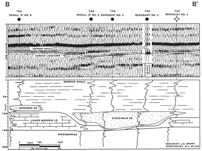
Synthetic seismogram traces generated from sonic and density logs run in the Bergquist No. 2 well are spliced into the seismic data of fig. 12 to show the tie with the subsurface data. Studies utilizing synthetic seismograms have shown that the generation of the "doublet" seismic event is primarily due to a tuning phenomenon as the Morrow shale to lower Morrow limestone interval thickens. As seen by the tie with the Edsall "G" No. 6 well, a Johannes sandstone lying in a thinner upper Morrow interval is, for all practical purposes, seismically transparent with this type of seismic data, which has a dominant frequency of about 65 Hz.
Seismic data have proved very effective in mapping the upper Morrow valleys in which Stockholm sandstones were deposited. The prediction of sandstone within these valleys, however, requires not only a knowledge of valley geometry but also an understanding of depositional environments. Development to the southwest of the Stockholm SW field in the Second Wind field was aided by the use of 3D seismic data, which can predict upper Morrow thickness changes as well as local structural changes with much greater precision than standard 2D seismic data.
Another geophysical tool that can be useful in the exploration for Morrow sandstones is magnetic data. Such data are most effective in mapping basement fault and compositional trends that may have had some indirect influence on later Morrow depositional trends.
The discovery of Stockholm SW rekindled interest in the Morrow play of southeast Colorado and western Kansas. Few would have expected a productive trend with over 250 producing wells spanning greater than 30 mi (48 km) to exist in this previously dormant area. The true extent of the play is still not clear. However, the impact of the play on the oil and gas industry of the region is dramatic, and the potential the play holds has kept operators active in the trend. The development of the Stateline trend has resulted in a better understanding of the valley-fill model of sedimentation, as well as an advancement in the use of seismic stratigraphy and associated modem seismic technology in this area. The lessons learned throughout the course of this activity increase the likelihood that the search for other such plays will be equally as successful.
This paper originally appeared under the Same title and by the same authors in the Rocky Mountain Association of Geologists 1990 Guidebook, Morrow Sandstones of Southeast Colorado and Adjacent Areas. Although the paper has since been modified, many of the figures and much of the text are the same as previously published. The authors would like to express their appreciation to the Rocky Mountain Association of Geologists for allowing much of this paper to be republished.
The authors also would like to acknowledge individuals previously employed by TXO who provided invaluable assistance, particularly Larry Coler for drafting the figures and Larry Webster for coordinating the reduction of final figures. Doug Isern and Rick Olmsted of Transwestern Petroleum, Mark Germanerio and Ross Matthews of UPRC, Inc., and Dallas Donner of Mull Drilling Co., Inc, provided additional well data that made this paper complete. A final acknowledgment is due Loren E. Avis, formerly of TXO, who is responsible for the drilling of the Stockholm SW discovery well.
Hurlbut, C. S., Jr., 1971, Dana's manual of mineralogy: John Wiley and Sons, New York, New York, 18th edition, 579 p.
Pettijohn, F. J., Potter, P. E., and Siever, R., 1972, Sand and sandstone: Springer-Verlag, New York, New York, 618 p.
Rader, K., 1987, Petrographic and subsurface analysis of Pennsylvanian Morrow sandstones of southwest Kansas: M.S. thesis, University of Colorado, Boulder, 106 p.; available from Kansas Geological Survey, Open-file Report 87-31
Stone, D. S., 1968, Wrench faulting and Rocky Mountain tectonics: The Mountain Geologist, v. 6, p.67-79
Swanson, D. C., 1979, Deltaic deposits in the Pennsylvanian Upper Morrow Formation of the Anadarko basin; in, Pennsylvanian Sandstones of the Midcontinent, N. J. Hyne, ed.: Tulsa Geological Society, Tulsa, Oklahoma, p. 115-168
Vail, P. R., Mitchum, R. M., and Thompson, S., 1977, Global cycles of relative changes of sea level; in, Seismic Stratigraphy-Application to Hydrocarbon Exploration, C. E. Payton, ed.: American Association of Petroleum Geologists, Tulsa, Oklahoma, p. 83-98
Yarger, H. L., Robertson, R. R., Martin, J., Ng, K., Sooby, R. L., and Wentland, R. L., 1981, Aeromagnetic map of Kansas: Kansas Geological Survey, Map Series M-16, 1 sheet
Previous--Damme Field, Finney County || Next--Coats South Area, Barber County
Kansas Geological Survey
Comments to webadmin@kgs.ku.edu
Web version placed online Oct. 20, 2015. Original publication date 1995.
URL=http://www.kgs.ku.edu/Publications/Bulletins/237/Miller3/index.html