![]()
Prev Page--Lorton Coal Bed || Next Page--Hugoton and Stevens Members
Lithostratigraphy of the Shore Airport Formation (Chesterian), Southwestern Kansas
by F. E. Abegg
Abstract
The Shore Airport Formation in the Hugoton embayment of the Anadarko basin is a new subsurface stratigraphic unit for peloid packstone and maroon calcareous shale of the previously unnamed strata in the Chesterian Stage. Shore Airport strata in southwestern Kansas are unconformably underlain by the Ste. Genevieve Limestone (Chesterian) and unconformably overlain by the Kearny Formation (Morrowan). Argillaceous Shore Airport strata are distinct from Ste. Genevieve quartzose carbonates that typically contain little shale. Lower Kearny strata generally contain increased percentages of siliciclastic and sandy marine carbonates. The unit is named for the Shore Airport SW 7.5-min quadrangle, Morton County, Kansas. A core from the Amoco #1 Breeding F (sec. 34, T. 31 S., R. 40 W.) contains 40.6 ft (12.4 m) of Shore Airport strata and is designated as the type section.
Two facies are recognized from the type section. Peloid packstone is greenish-gray to maroon in color and is the dominant facies. Paucity of stenohaline marine allochems, fine grain size, and micrite matrix indicate deposition in a low-energy, restricted-shelf environment. Rhizoliths, drab-haloed root traces, and glaebules suggest reddish color in maroon peloid packstone intervals accumulated in a Bs soil horizon (zone of illuvial accumulation of sesquioxides). These paleosols are interpreted as inceptisols (sesquioxide-rich, clay-poor paleosols).
Peloid packstone is intercalated with maroon calcareous shale. Slickensides, glaebules, drab-haloed root traces, rhizocretions, and blocky peds indicate these maroon shale intervals formed in a Bt soil horizon (zone of illuvial accumulation of clay and sesquioxides). The paleosols are interpreted as alfisols (sesquioxide-rich, clay-rich paleosols).
Introduction
Mississippian strata in Kansas are confined to the subsurface, with the exception of outcrops of Burlington-Keokuk Limestone and Warsaw (Osagean) in two townships in Cherokee County, in the extreme southeastern corner of the state (Thompson and Goebel, 1968; Kammer et al., 1990; Maples, this volume). In nearby states, Chesterian strata crop out in southwestern Missouri (Thompson, 1986), northwestern Arkansas (Glick, 1979), and northeastern Oklahoma (Frezon and Jordan, 1979). Outcrops of Chesterian strata are absent from Colorado, with the exception of the extreme northwestern part of the state (DeVoto, 1980).
Little detail is known about the lithology and deposition of the previously unnamed portion of the Chesterian in southwestern Kansas. Amoco #1 Breeding F is proposed as a type section for the Shore Airport Formation (Chesterian, new name), because it contains contacts with the underlying Ste. Genevieve Limestone and the overlying Kearny Formation. In the type section, the Shore Airport Formation consists of peloid packstone and maroon calcareous shale. Argillaceous Shore Airport strata are distinct from underlying Ste. Genevieve quartzose carbonates that typically contain little shale. Overlying lower Kearny strata generally contain increased percentages of siliciclastic and sandy marine carbonates. Core study of the Shore Airport is important in increasing our understanding of sedimentation of Upper Mississippian strata.
Previous Investigations
Most previous authors refer to Chesterian strata in southwestern Kansas as all Mississippian strata above the Ste. Genevieve Limestone. In this report, however, the Ste. Genevieve is also considered to be Chesterian (Maples and Waters, 1987). In discussion of previous works, however, the reference to Chesterian strata excludes the Ste. Genevieve.
Strata of Chesterian age were first recognized, but not described, by Robert Roth (in McClellan, 1930, p. 1,548) from samples of the uppermost 400 ft of the Mississippian from Watchorn Oil and Gas Company #2 Morrison in Clark County (Lee, 1940). Chesterian strata in southwestern Kansas were originally described by McClellan (1930). Dille (1932) identified Chesterian strata from northwestern Oklahoma, southwestern Kansas, and southeastern Colorado. Chesterian strata also have been reported from southeastern Kansas (Lee, 1940; Goebel, 1968). The identification of Chesterian strata in southeastern Kansas, however, was probably erroneous (Maples, this volume).
Clair (1948, 1949) provided details on the lithology of Chesterian strata in southwestern Kansas. Based on cuttings, Clair recognized three lithologic groups in southwestern Meade and southeastern Seward counties (in ascending stratigraphic order): 1) variegated maroon and green shales or sandy limestones; 2) finely crystalline, very finely sandy limestone intercalated with variegated gray, green, and maroon shales; and 3) slightly porous oolitic and fossiliferous limestone. The Shore Airport Formation in the Amoco #1 Breeding F is lithologically similar to the interstratified fine-grained limestones and variegated shales described by Clair (1948, 1949) and Beebe (1959a, 1959b). Although absent in the Amoco #1 Breeding F, sandstones occur locally at the base of the Shore Airport in Haskell, Stevens, and Seward counties (Clair, 1948, 1949; Veroda, 1959; Fugitt and Wilkinson, 1959; Shonfelt, 1988). In addition, Goebel (1968) and Goebel and Stewart (1979) provided generalized descriptions of Chesterian strata.
Oolites at the top of the Shore Airport are petroliferous and comprise the reservoir beds of the Adams Ranch Pool in Meade County, Kansas (Clair, 1948, 1949). Oolitic grainstones are productive from uppermost Chesterian strata in the panhandle of Oklahoma (Asquith, 1984). This facies is absent from the type section of the Shore Airport Formation in Morton County. Oolitic grainstones may have been removed by Late Mississippian-Early Pennsylvanian erosion associated with the sub-Pennsylvanian unconformity.
Regional Geology and Stratigraphy
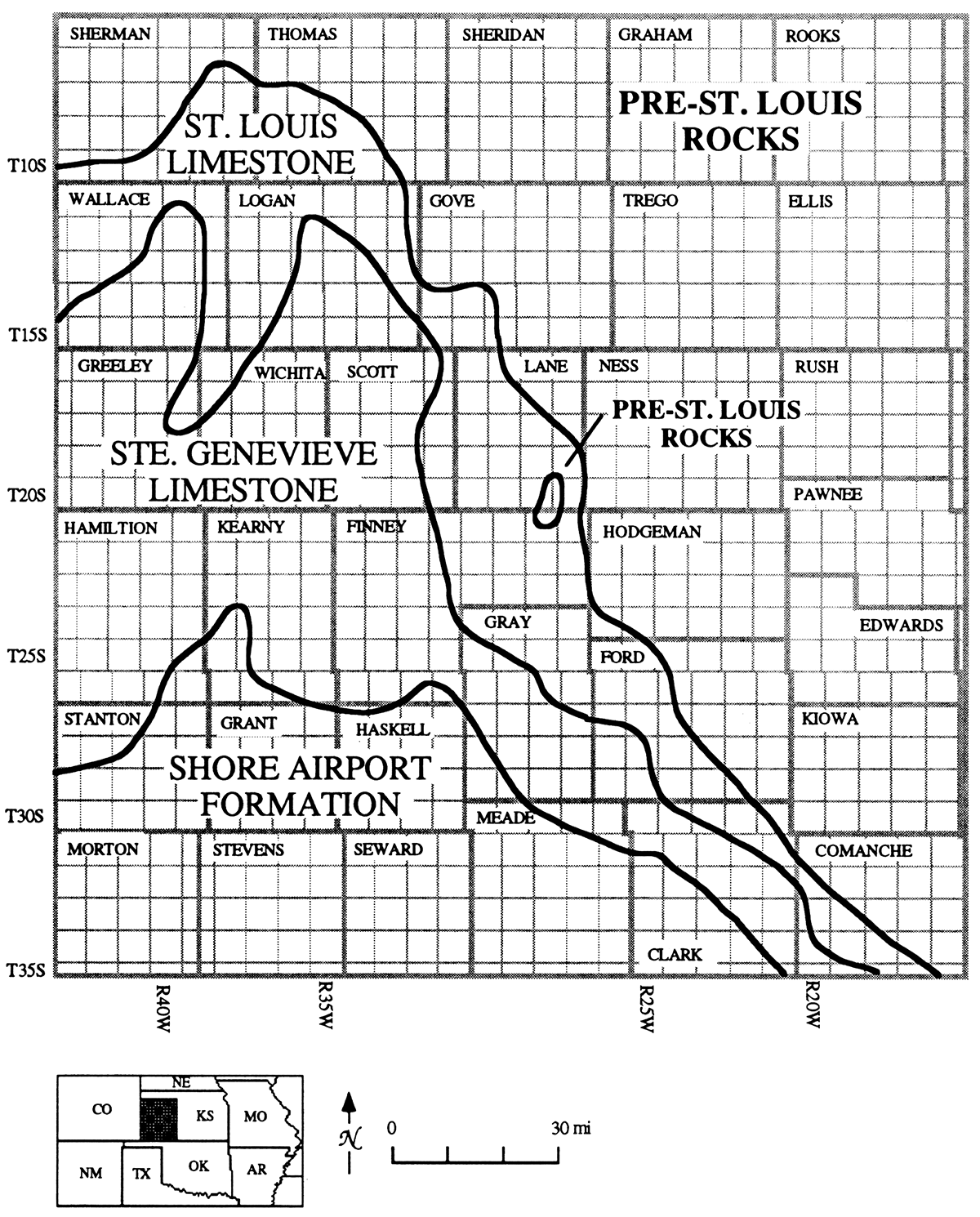
Shore Airport strata in Kansas are presently restricted to the southwestern part of the state (fig. 1). The original extent of Shore Airport strata is unknown due to erosion associated with subaerial exposure during Late Mississippian-Early Pennsylvanian time.
Figure 1—Subcrop map of Mississippian strata beneath the sub-Pennsylvanian unconformity in Kansas (modified from Thompson and Goebel, 1968). St. Louis strata are eroded from southeastern Lane and adjacent Finney counties.
Mississippian carbonates in Kansas were deposited on a shelf that extended southward from the Transcontinental arch. Deposition of argillaceous carbonates and siliciclastics of the Shore Airport marks the termination of dominantly carbonate deposition that continued throughout much of Mississippian time (Lane and De Keyser, 1980).
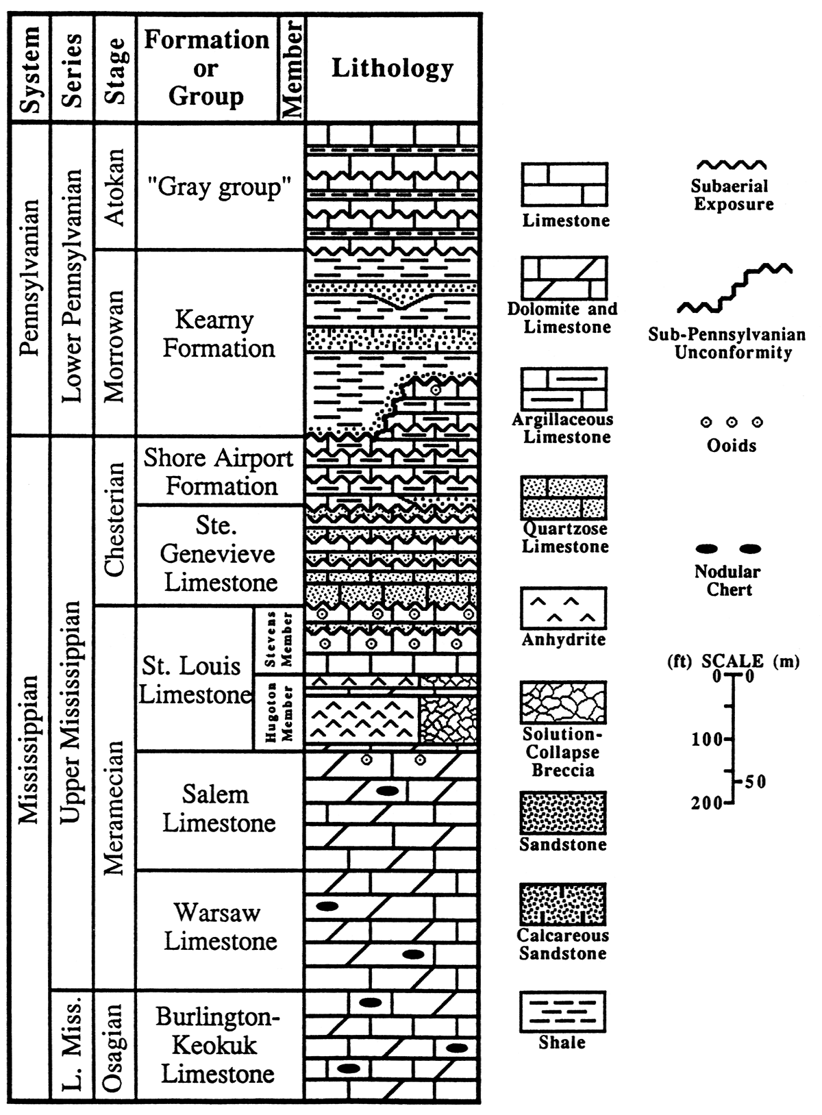
Shore Airport strata are underlain by the Ste. Genevieve Limestone (Chesterian) (fig. 2). Many of the quartzose grainstones in the Ste. Genevieve of southwestern Kansas are eolian in origin (Handford, 1990; Handford and Francka, 1991; Abegg, 1991, this volume). These eolianites are interbedded with subtidal strata (Abegg, 1991, this volume). Shore Airport strata are truncated at the sub-Pennsylvanian unconformity and are overlain by Morrowan strata. In Clark County, the informal "Gray group" (cf. Youle, 1991) and locally the Cherokee Group overlie the Shore Airport Formation (Goebel and Stewart, 1979).
Figure 2—Upper Mississippian lithostratigraphic units in the HUgoton embayment of the Anadarko basin in western Kansas. Shore Airport Formation (Abegg, this paper), Hugoton and Stevens Members of the St. Louis Limestone (Abegg, this volume), and "Gray group" (Youle, 1991) are new names. The sub-Pennsylvanian unconformity erodes the entire Mississippian over the Central Kansas uplift and the Nemaha anticline. Meramecian-Osagean boundary after Kammer et al. (1990). Scale is approximate as thicknesses are variable.
Methods
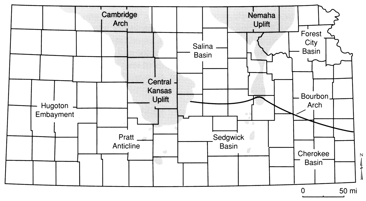
This report stems from a more comprehensive study (Abegg, 1992) that examines Upper Mississippian strata in the Hugoton embayment of the Anadarko basin (fig. 3) in southwestern Kansas. The Amoco #1 Breeding F core was described at a scale of 1:12. Carbonate textures were described using the classification scheme of Dunham (1962). A total of 61 thin sections were examined from the Breeding core. Stratigraphic cross sections of Shore Airport, Ste. Genevieve, St. Louis, and Salem strata will be presented separately (Abegg, 1992).
Figure 3—Late Mississippian-Early Pennsylvanian tectonic features (modified from Merriam, 1963; Ebanks et al., 1979). Shaded areas represent regions where Mississippian strata are absent due to Late Mississippian-Early Pennsylvanian erosion.
Shore Airport Formation (Chesterian, New Name)
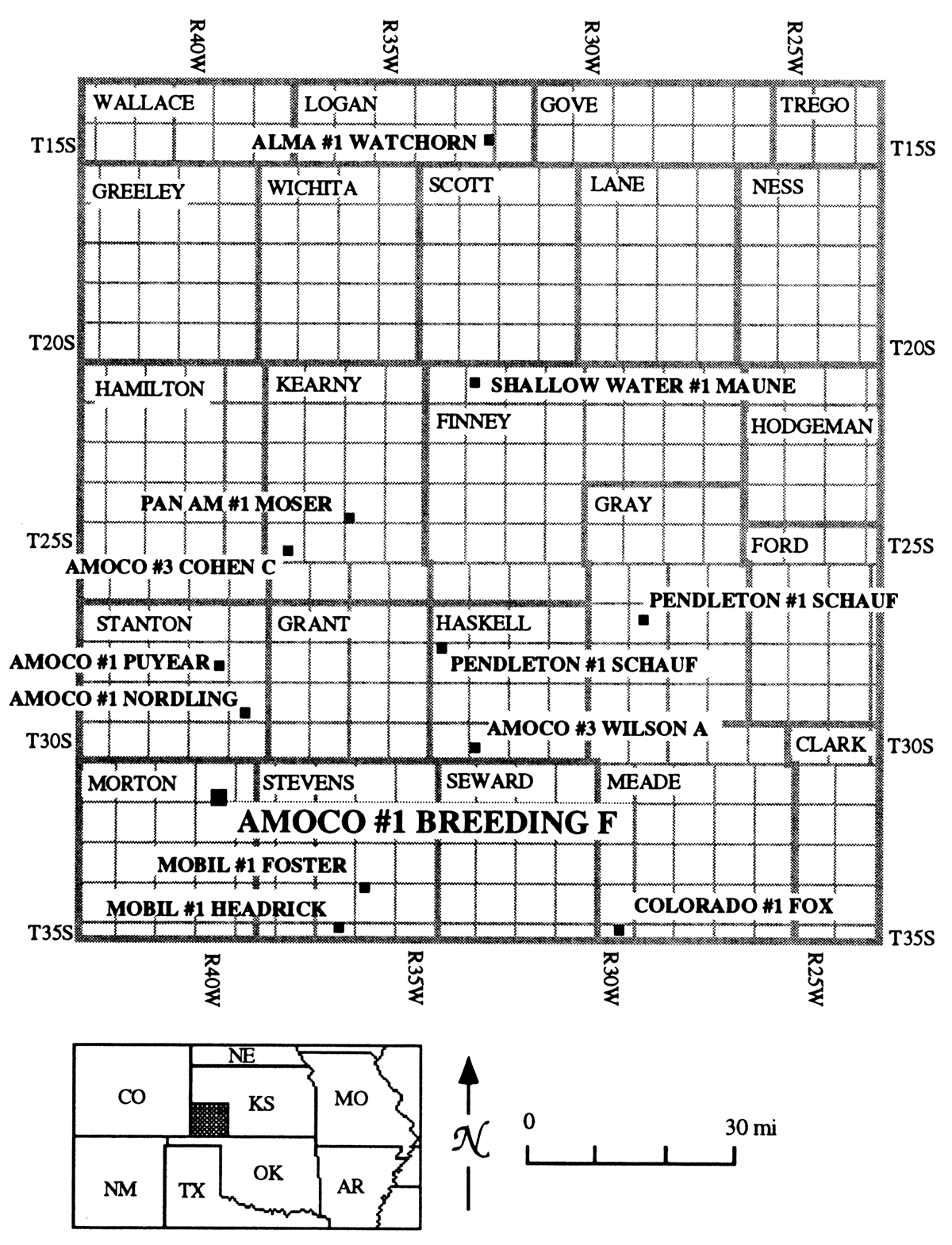
The core proposed for the type section of the Shore Airport Formation is from the Amoco #1 Breeding F, located in SW sec. 34, T. 31 S., R. 40 W., Morton County, Kansas (fig. 4). The type section is located in and named for the Shore Airport SW 7.5-minute quadrangle. The core is currently stored at the Kansas Geological Survey core facility in Lawrence, Kansas. This well was selected as the type section because it is the most complete Shore Airport core available and it contains the contacts with both the underlying Ste. Genevieve Limestone and the overlying Kearny Formation (Morrowan). Stratigraphic names from Chesterian outcrops in nearby regions were not applied because they generally represent different facies than those present in southwestern Kansas.
Figure 4—Map of southwestern Kansas showing location of Upper Mississippian cores logged. Amoco #1 Breeding F is located in northeastern Morton County (sec. 34, T. 31 S., R. 40 W.).
Type Section Facies
The Shore Airport Formation is 40.6 ft (12.4 m) thick in the Amoco #1 Breeding F; it extends from 5,282.05 to 5,322.65 core depth (fig. 5). Comparison of gamma ray peaks and porous intervals in core and logs indicate log depths are approximately 10 ft deeper than corresponding core depths (fig. 6). Peloid packstone and maroon calcareous shale are the two lithofacies recognized in the type section of the Shore Airport Formation.
Figure 5—Description of core from the Amoco #1 Breeding F. Wireline log depths are roughly 10 ft deeper than core depths. Right-hand track shows interpretations of shifts in depositional environments. Dashed lines represent shifts without deposition. Horizontal wavy lines are subaerial exposure surfaces or surfaces bracketing eolian strata. Abbreviations used: SE—subaerial exposure; I—intertidal or tidally influenced; L—restricted lagoon/shelf; SH—oolitic or skeletal shoal; SM—shallow marine with evidence of at least intermittent agitation, above or near wave base (WB); M—marine with little winnowing, below wave base; AD—separates dysaerobic and anaerobic facies from overlying aerobic facies. Depositional textures are also abbreviated: GR—grainstone, PK—packstone, WK—wackestone, LM—lime mudstone. Formations (FMS) are listed in the depth track.
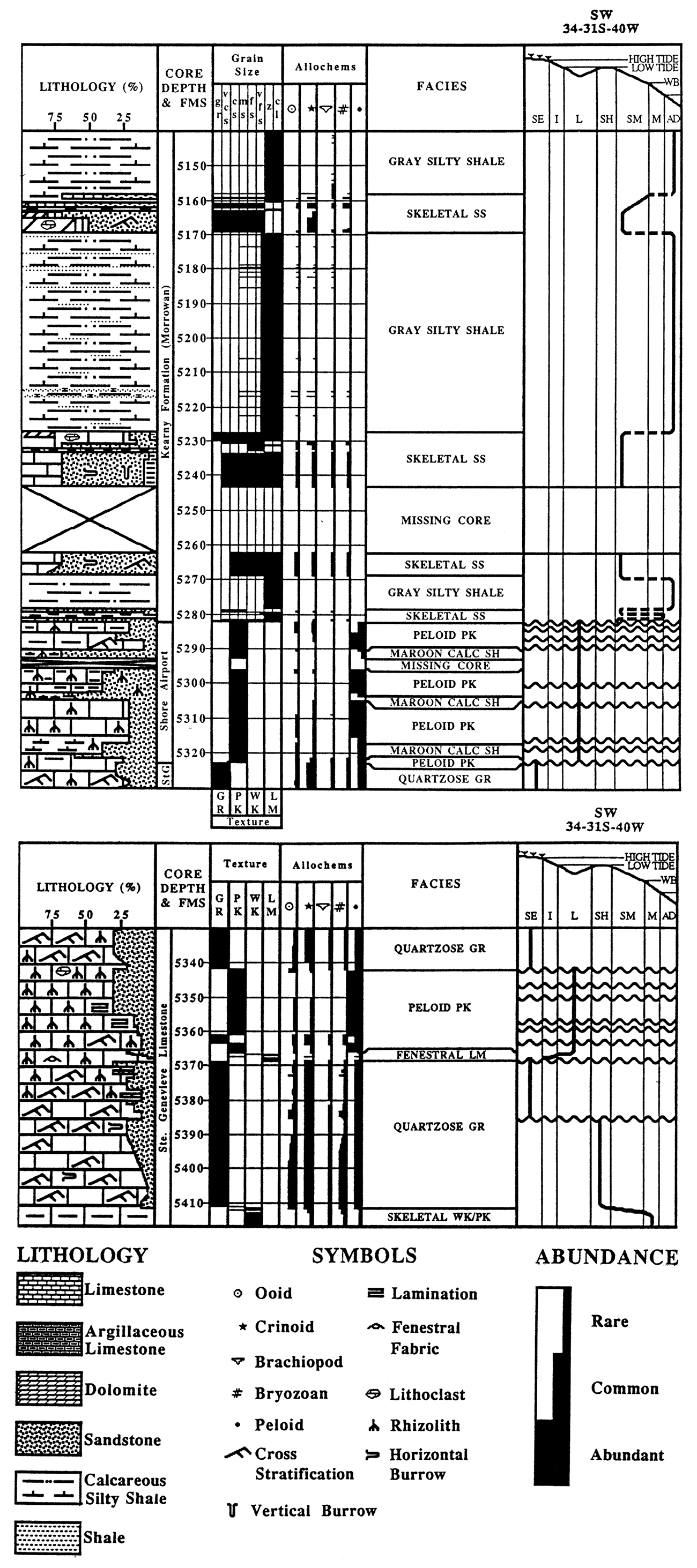
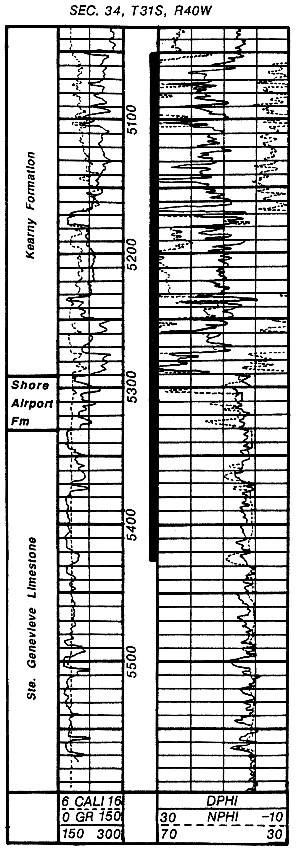
Figure 6—Gamma ray-neutron density log from the Amoco #1 Breeding F, Morton County. Kansas. Tops are picked from a combination of core analysis and cross section correlations. Cored interval is indicated by the thick line in depth track. Depths in feet.
Peloid Packstone Facies
This facies consists of greenish-gray to maroon packstones. Peloids are common to abundant and are the dominant allochem in this facies. Rare to common grains include echinoderms, lithoclasts (intraclasts?), and ooids. Many of the ooids are extensively micritized. Rare allochems include fragments of brachiopods and bryozoans, foraminifera, ostracodes, and sponge-spicule casts. Detrital quartz of silt to very fine sand size comprises approximately 10-40% of the peloid packstone facies. Muscovite, feldspar, zircon, and amphibole are minor constituents. Peloid packstones are typically argillaceous with maximum clay concentrations along microstylolite swarms. Clays exhibit moderate to low birefringence and have refractive indices lower than quartz. This suggests much of the clay is smectite.
Peloid packstone is commonly laminated (fig. 7). Laminae are the result of grain-size and compositional variations; finer laminae contain greater concentrations of silt and detrital quartz. Laminae are partially disrupted locally. Tubes in the shale, some filled with sparry calcite, are commonly rimmed by green haloes with diffuse outer boundaries. Greenish color is generally restricted to such haloes. The upper few centimeters of one maroon peloid packstone (5,287.2-ft [1,586-m] core depth) contained irregular patches of greenish-gray material. Rarely the larger spar-filled tubes are rimmed by vaguely laminated brownish micrite. Downward bifurcations with smaller diameters were not observed in any of the tubes. Well-indurated reddish grains occur locally.
Figure 7—Peloid packstone with laminations and microstylolite swarms (M). 5,315-5,316-ft [1,595-m] core depth, Amoco #1 Breeding F.
![Peloid packstone with laminations and microstylolite swarms (M). 5,315-5,316-ft [1,595-m] core depth, Amoco #1 Breeding F.](gifs/figD7.jpg)
Microstylolite swarms are common in most horizons. Often the limestone surrounding the calcite spar-filled tubes resists compaction, producing a nodular appearance. These nodules grade into stylolitized regions. Few interpenetrating grain contacts and abundant equant calcite cements in the nodules indicate compaction was minor. Calcite-cemented fractures that taper toward the center of nodules are common. Equant and syntaxial overgrowth calcite cements occur in the unstylolitized strata, but are nearly absent from microstylolitized intervals.
This facies is intercalated with the maroon calcareous shale facies of the Shore Airport (fig. 5). Peloid packstone is also interstratified with uppermost Ste. Genevieve quartzose grainstone, indicating an interfingering of Ste. Genevieve and Shore Airport facies.
Interpretation
Mud-poor packstones and rare stenohaline marine biota indicate peloid packstone was deposited in a shallow-water, restricted-shelf environment. Mud-poor packstones and ooids indicate winnowing in an intermittently agitated environment. Stenohaline marine organisms such as crinoids and brachiopods are rare, suggesting that salinities deviated from marine values. The restriction may be the result of poor circulation in shallow shelf waters. Alternatively, ooid shoals to the south (Asquith, 1984) may have provided a barrier to circulation with normal marine waters.
The spar-filled tubes and vaguely laminated brownish micrite are interpreted as root casts surrounded by rhizocretions (cf. Klappa, 1980). Many of the tubes, however, lack rhizocretions and a burrow origin cannot be discounted. Associated with rhizoliths, maroon color in clay-poor peloid packstones probably results from concentration of sesquioxides in the Bs horizon of poorly developed paleosols (see table 1 for definitions of soil terms). Greenish-gray color and rhizoliths above these Bs horizons suggest possible A horizons. Greenish-gray patches near the top of one maroon peloid packstone interval (5,287.2-ft [1,586-m] core depth) occur immediately below a transgressive surface and are interpreted to indicate subtidal reduction of iron. Wellindurated sesquioxide-rich grains are interpreted as glaebules (cf. Brewer, 1976; Retallack, 1990).
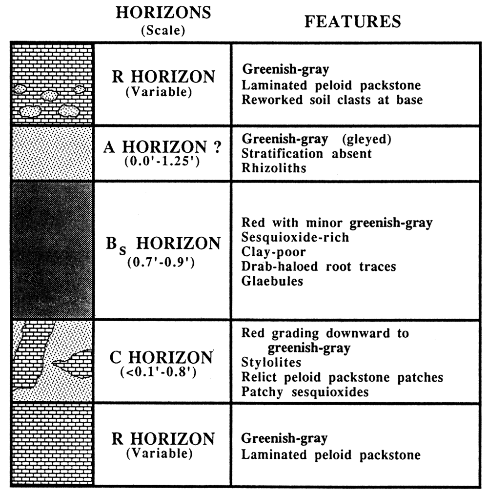
Table 1—Definitions of soil terms used in this report; information modified from Retallack (1988, 1990) and additional sources cited.
| Sesqnioxide | oxides and hydroxides of iron or aluminum. The term indicates that compounds have one-half times as many O2- ions as Fe3+ or Al3+ ions. In general, the most common sesquioxides are hematite, goethite, or gibbsite (Hausenbuiller, 1978). In this report, used for reddish intervals that are probably hematitic. |
| Glaebule | local concentrations of such minerals as sesquioxides (modified from Brewer, 1976). Drab-haloed root trace-root surrounded by a rim of reduced iron. |
| Peds | aggregates of soil material between openings (e.g., cracks, roots, etc.) in the soil. |
| Blocky peds | equant peds with dull interlocking edges. |
| IIluviation cutans | cutans are a modification of soil material along natural surfaces caused by the concentration of a particular constituent. IIIuviation cutans form by material washed down into cracks in the soil. |
| Slickensides | formed by expansion and contraction of soils due to alternating periods of wetting and drying or during compaction. Termed stress cutans in soil terminology. |
| A soil horizon | soil zone that contains roots and a mixture of mineral or organic matter. |
| B soil horizon | soil zone enriched in some material relative to or more weathered than adjacent horizons. |
| Bs soil horizon | B horizon marked by illuvial accumulation of sesquioxides. |
| Bt soil horizon | B horizon marked by accumulation of clay. |
| C soil horizon | slightly more weathered than underlying fresh bedrock. |
| R soil horizon | consolidated and unweathered bedrock. |
| Alfisol | soil with well-developed Bt horizon, often red with sesquioxides. |
| Entisol | very weakly developed soil, typically marked only by roots. |
| Inceptisol | weakly developed soil, typically marked by roots and an incipient clayey and sesquioxidic Bs horizon. |
Maroon Calcareous Shale Facies
Clays in the shale have moderate to low birefringence and refractive indices less than quartz. This suggests much of the clay is smectite. Detrital quartz of very fine sand to silt size comprises up to 40% of this facies. Muscovite is rare and feldspar is extremely rare. Microspar is present locally. Maroon is the dominant color, although greenish-gray occurs locally, producing a variegated appearance. Maroon calcareous shale contains localized patches of slightly weathered limestone that are lithologically similar to interstratified peloid packstone (fig. 8). Borders of these peloid packstone patches are commonly stylolitized.
Figure 8—Maroon calcareous shale (5,316.8-5,319.0 ft [1,595-1,596 m] and 5,319.5-5,320.2 ft ( 1,596 m)) interbedded with peloid packstone. Light patches (just above 5,320 ft [1,596 m]) are interpreted as drab-haloed root traces (D) formed by the reduction of iron during anaerobic decay. 5,315-5,321-ft (1,594-1,596-m) core depth, Amoco #1 Breeding F.
![Maroon calcareous shale (5,316.8-5,319.0 ft [1,595-1,596 m] and 5,319.5-5,320.2 ft ( 1,596 m)) interbedded with peloid packstone.](gifs/figD8.jpg)
Tubes in the shale, some filled with sparry calcite, are often rimmed by a green halo with a diffuse outer boundary (fig. 8). Greenish color is generally restricted to such haloes. Well-indurated dark-maroon grains are rare. Many broken surfaces of the core are glossy and striated. Cores of this facies invariably are rubbly, breaking into roughly equant blocks.
Interpretation
This facies is interpreted as a clay-rich alfisol Bt horizon. Such reddish shaly intervals in limestone successions are commonly termed terra rossa paleosols (e.g., Goldhammer and Elmore, 1984). Clay and sesquioxides are interpreted to have been concentrated during paleosol development. The near absence of feldspar may be the result of weathering and subsequent breakdown to clays. The rubbly nature of the core is due to blocky peds and a high clay content.
The tubes are interpreted as roots (cf. Klappa, 1980). The greenish rims around many of these features are interpreted as drab-haloed root traces (Retallack, 1990). Diffuse outer boundaries indicate that drab-haloed root traces formed by the reduction of iron around roots during anaerobic decay (cf. Retallack, 1990). Glossy and striated surfaces are slickensides, which are common in clay-rich paleosols. Slickensides form by expansion and shrinkage due to alternating wet and dry periods or during compaction (Retallack, 1990). Well-indurated, dark-maroon grains are interpreted as glaebules (cf. Brewer, 1976). Slightly weathered peloid limestone patches are relatively unaltered parent material (Iithorelicts of Brewer, 1976).
Shore Airport Paleosols
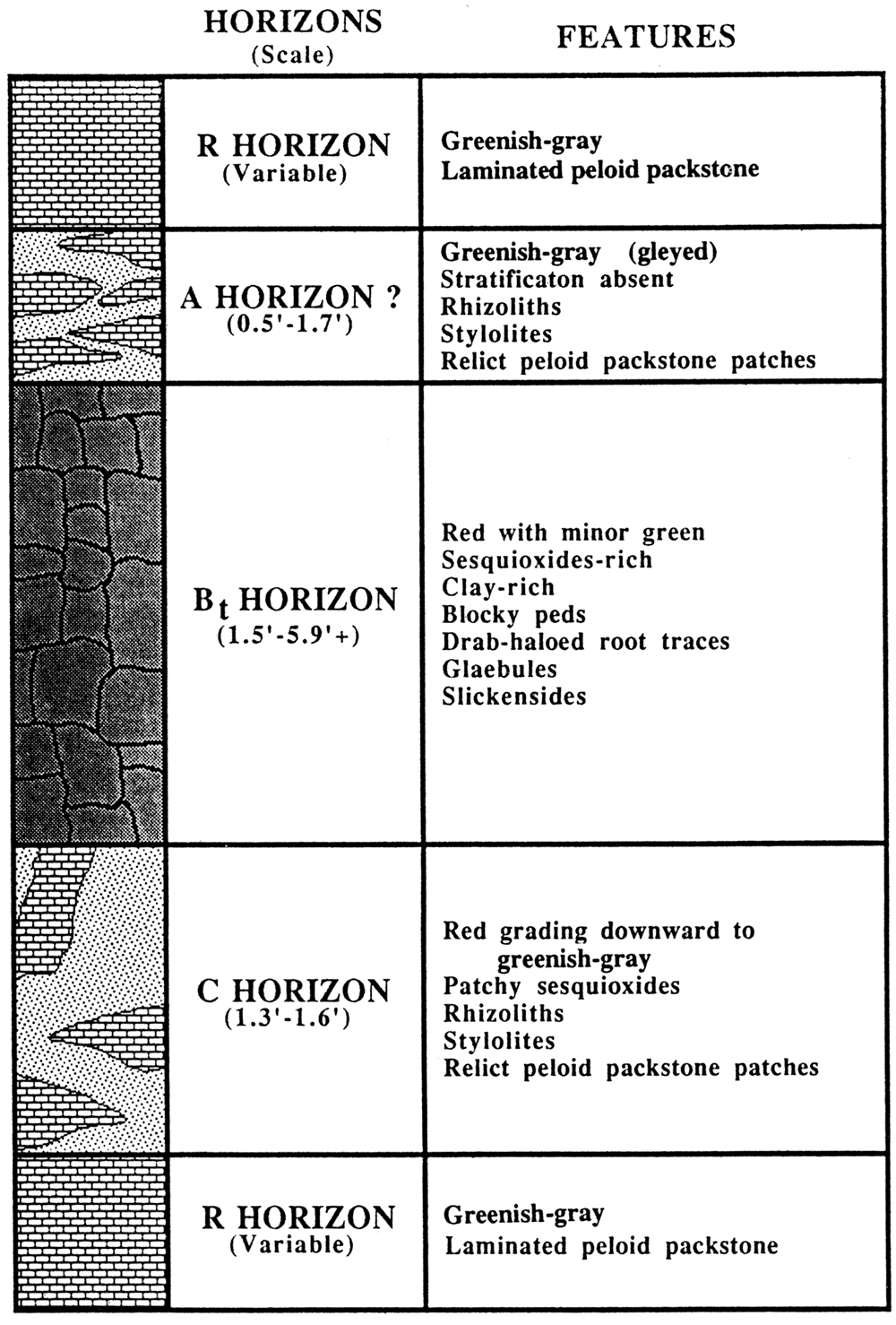
The two types of paleosols recognized in the Shore Airport type section are inceptisols and alfisols. The exact boundaries of A and C horizons within these paleosols are commonly difficult to recognize. Sesquioxide- and/or clay-rich B horizons, however, are easily identified. Figure 9 shows the distribution of horizons in paleosols in the Shore Airport Formation.
Inceptisols
Inceptisols are paleosols with relatively minor soil development (Retallack, 1990). Maroon color in the peloid packstone facies is the Bs horizon of inceptisols (fig. 10). Sesquioxides have accumulated in the Bs horizon, but significant clay illuviation has not occurred. Rhizoliths, drab-haloed root traces, and glaebules also typify inceptisol B, horizons. The maroon color suggests these paleosols were generally well drained and oxidized.
Possible A horizons of inceptisols consist of green, argillaceous peloid packstone. The green color suggests reduction of iron (gleying), possibly the result of near-surface anaerobic decay of organic material. The upper contact of the A horizon marks a transgression over the exposure surface. Reworked clasts from the underlying paleosol occur locally. This transgressive surface is typically difficult to recognize; sometimes it can be approximated by a change from unstratified intervals with roots to laminated peloid packstone. Because of the difficulty in recognizing a transgressive surface, some intervals tentatively interpreted as A horizons (fig. 9) may represent strata deposited following transgression.
The C horizon is a transitional zone from the overlying sesquioxide-rich Bs horizon to the underlying unweathered peloid packstones. Exact boundaries to the C horizon are arbitrary.
Figure 9—Soil horizons in the type section of the Shore Airport Formation. Identification of A horizons is often uncertain and boundaries of C horizons are gradational and thus arbitrary. Sesquioxide-rich and clay-rich Bt horizons along with sesquioxide-rich and clay-poor Bs horizons are easily identifiable.
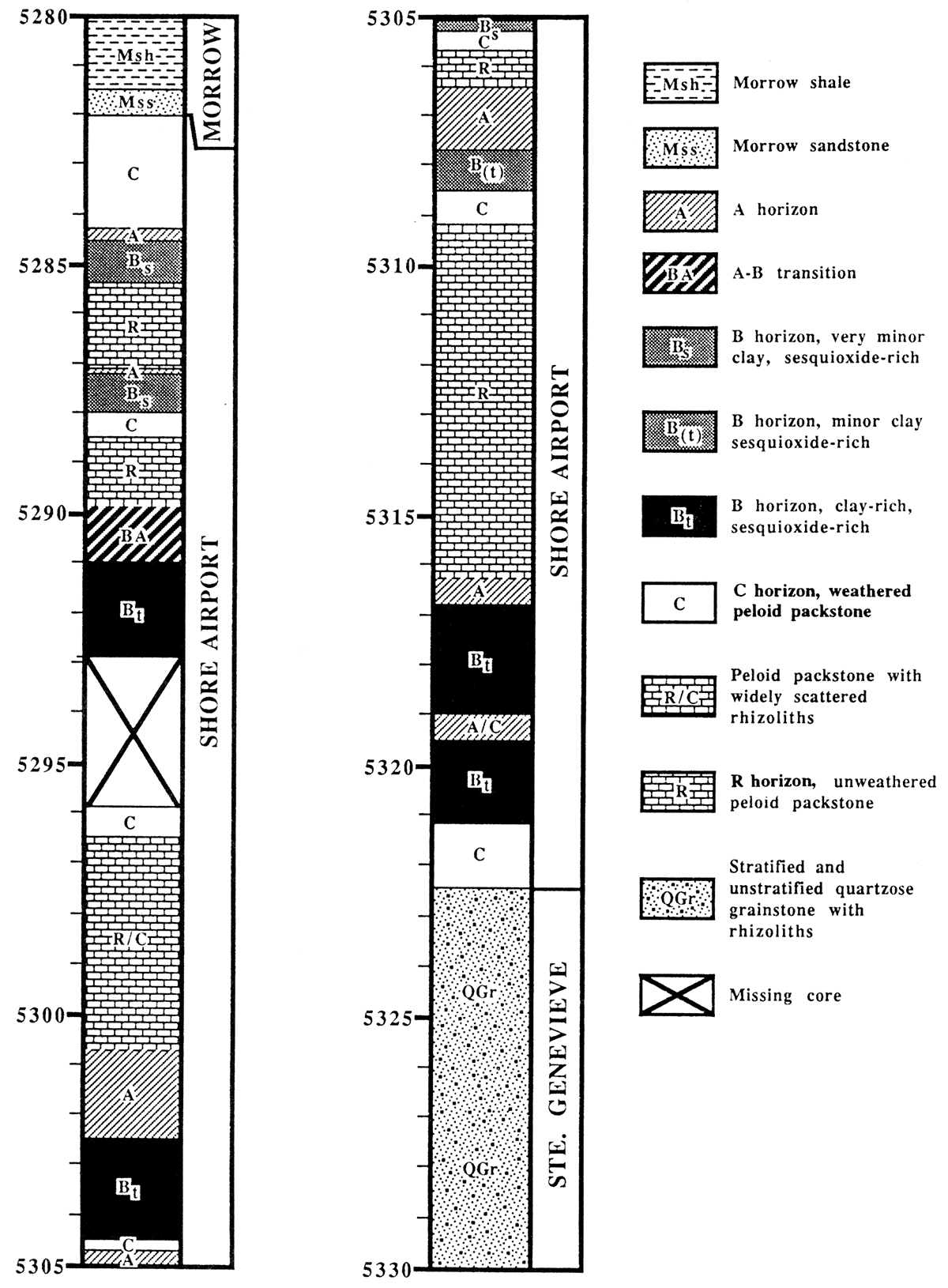
Figure 10—Inceptisols showing horizons and features in the Shore Airport Formation type section.
Alfisols
Alfisols are marked by a light-colored A horizon? underlain by a clay-rich Bt horizon. The red calcareous shale facies of the Shore Airport Formation is interpreted as an alfisol sesquioxide- and clay-rich Bt horizon (figs. 8 and 11). These Bt horizons also contain well-developed blocky peds, slickensides, drab-haloed root traces, and glaebules. Goldhammer and Elmore (1984) interpreted similar lithologies from the Pennsylvanian Black Prince Limestone in Arizona to be terra rossa paleosols resulting from the accumulation of insoluble residues with the dissolution of limestone. Relicts of argillaceous limestone indicate that dissolution may account for much of the silt and shale in the Shore Airport.
The A horizon is typically difficult to identify in the Shore Airport alfisols. The boundary with the B horizon is probably gradational, but this contact is difficult to observe in core because it is usually rubbly. Possible A horizons consist of unstratified gleyed shaly packstone with scattered rhizoliths, locally with well-developed root casts and rhizocretions. Overlying strata are commonly laminated. Similar to inceptisols, the difficulty in recognizing a transgressive surface suggests some intervals tentatively interpreted as A horizons (fig. 9) may represent strata deposited following transgression.
The C horizon is the transition from the overlying Bt horizon to underlying unweathered peloid packstones. Decreasing amounts of clay and sesquioxides occur toward the base of this horizon. The boundaries of the C horizon are gradational and arbitrary.
Figure 11—Alfisols showing horizons and features in the Shore Airport Formation type section.
Ste. Genevieve Facies
The Ste. Genevieve Limestone consists of four facies: 1) skeletal wackestone/packstone, 2) quartzose grainstone, 3) fenestral lime mudstone, and 4) peloid packstone (fig. 5). The peloid packstone in the upper Ste. Genevieve is similar to that in the Shore Airport; it is included in the Ste. Genevieve because it is interstratified between two quartzose grainstone intervals. The upper boundary of the Ste. Genevieve is marked by the top of the uppermost quartzose grainstone. In order to define the lower contact, only the uppermost Ste. Genevieve quartzose grainstone and the peloid packstone facies need to be described below. Details of these and other Ste. Genevieve facies are included in Abegg (1992).
Quartzose Grainstone Facies
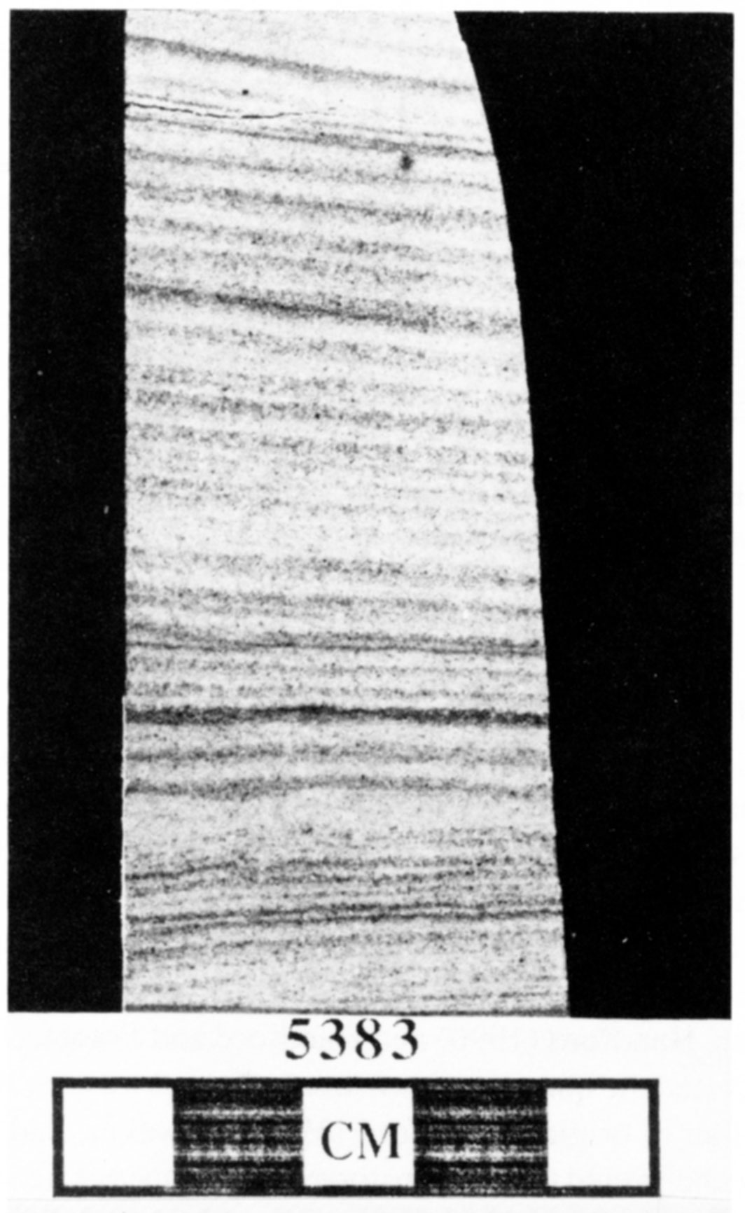
Allochems are almost invariably broken and well rounded, regardless of their original shape. Common grains include peloids and echinoderms. Bryozoans and ooids are common to rare. Brachiopods, trilobites, foraminifera, sponge spicule casts, and lithoclasts are rare. Glauconitic grains and cubic pyrite are scattered throughout. Detrital quartz sand varies between 5% and 30% and is mostly very fine grained, although grain size ranges from very coarse silt to medium sand. Quartzose grainstones often can be recognized on wireline logs by a crossover in the neutron and density curves with higher neutron porosities than density porosities (fig. 6). Other detrital grains are rare, including feldspar, zircon, and amphibole. Muscovite, detrital chert, and phosphatic grains are very rare. Cross stratification is typically less than 15°, but locally as high as 32°. Much of this facies is marked by climbing trans latent stratification (fig. 12).
Figure 12—Climbing translatent strata, typically 2-5 mm thick, formed by the migration of climbing wind ripples from the Ste. Genevieve quartzose grainstone facies. Each climbing translatent stratum consists of a basal dark interval of mostly very fine sand that grades upward to a lighter interval that typically contains medium sand. 5,383-ft (1,615-m) core depth, Amoco #1 Breeding F.
Interpretation
The majority of quartzose grainstone is interpreted as carbonate eolianites. Coarsening-upward grain size and rare ripple-foreset laminae indicate that the climbing translatent stratification (fig. 12) is of eolian origin (cf. Hunter, 1977, 1981; Kocurek and Dott, 1981; Kocurek, 1991). However, discontinuous and disrupted stratification in quartzose grainstone is interpreted as bioturbated subtidal deposits (fig. 5). Hunter (1989) described a quartz-rich limestone facies from the lllinois basin in southern Indiana. He also ascribed an eolian origin. Based on similarities with Hunter's examples, Handford (1990) and Handford and Francka (1991) interpreted the quartzose grainstone of southwestern Kansas as eolian in origin. Handford (1988), however, had previously interpreted these grainstones as subaqueous tidal channels. Eolian quartzose grainstones have been identified over much of the Hugoton embayment (Handford and Francka, 1991; Abegg, 1992).
Peloid Packstone Facies
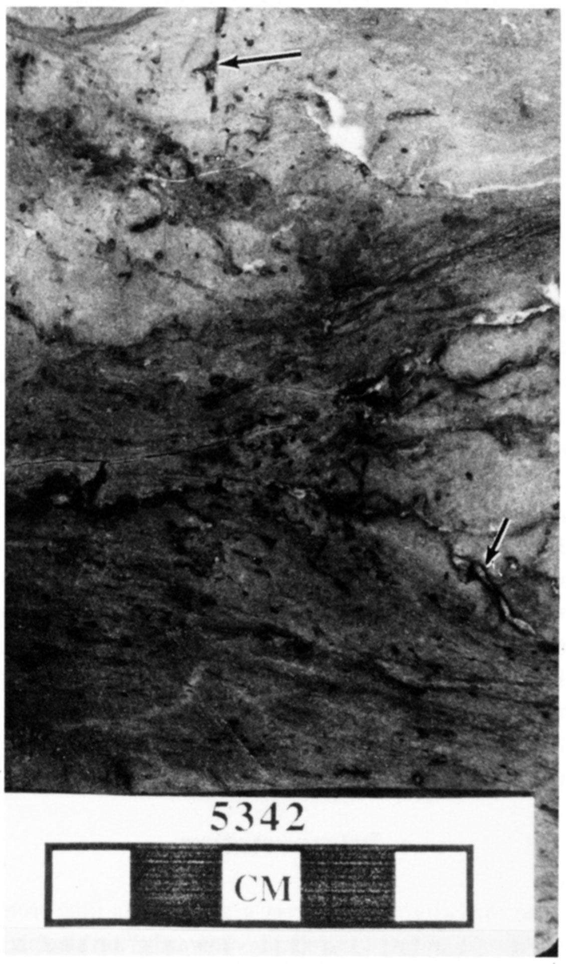
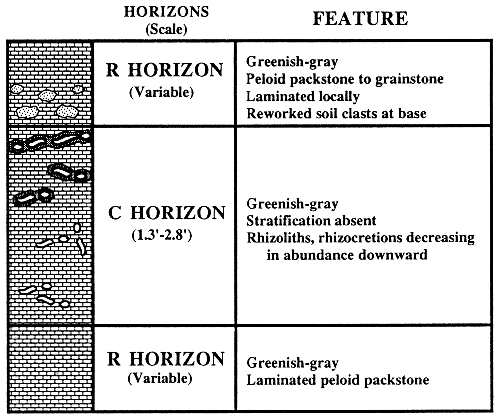
The peloid packstone in the upper Ste. Genevieve Limetone is nearly identical to the same facies in the Shore Airport. The peloid packstone in the Ste. Genevieve include the following features not observed in the peloid packstone in the Shore Airport: 1) very thin grainstone intervals, 2) posible Microcodium that is calcification of mycorrhizae (fungal and root associations) (Klappa, 1978), 3) absence of interbedded sesquioxide- or clay-rich intervals, 4) fewer microstylolite swarms, and 5) more abundant calcite cementfilled tubes, many with dark-brown, vaguely laminated micrite coatings (fig. 13). These tubes are concentrated at particular horizons. Tubes with well-developed micritic coatings typically grade downward to tubes lacking such coatings (fig. 14).
Figure 13—Peloid packstone from the Upper Ste. Genevieve. Tubes (arrows) surrounded by vaguely laminated micrite are interpreted as root casts and rhizocretions respectively, collectively termed rhizoliths. Rhizoliths are the only feature that marks these poorly developed paleosols (entisols). 5,342-ft (1,603-m) core depth, Amoco #1 Breeding F.
Interpretation
Rare stenohaline marine biota indicates peloid packstone was deposited in a restricted-shelf environment. Periodic winnowing and ooids indicate an intermittently agitated shallow-water environment. Stenohaline marine organism such as crinoids and brachiopods are rare, suggesting that salinities deviated from normal-marine values or that environmentally stressed conditions existed. The restriction may result from poor circulation in shallow shelf water. Alternatively, ooid shoals also may have contributed to restricted circulation.
The calcite cement-filled tubes are interpreted as root casts and micritic coatings are rhizocretions (cf. Klappa, 1980). Similar rhizoliths occur much less frequently in the peloid packstone facies of the Shore Airport. Upper Ste. Genevieve rhizoliths in peloid packstone intervals are concentrated near the top of paleosols. Rhizoliths with welldeveloped rhizocretions typically grade downward to root casts lacking rhizocretions; however, a burrow origin for tubes without rhizocretions cannot always be discounted. Because the only indications of paleosols are local concentrations of rhizoliths, these paleosols are interpreted as entisols (fig. 14). Entisols (table 1) characteristically contain parent lithologies that are nearly unaltered by soil processes due to a lack of time or unfavorable conditions for soil development (Retallack, 1990).
Figure 14—Entisols showing horizons and features in the Shore Airport Formation type section. Reworked soil clasts are rare. Root casts without rhizocretions grade upward to rhizoliths with increasingly thicker rhizocretions.
Kearny Formation (Morrowan) Facies
The basal Kearny Formation (Morrowan) in the Amoco #1 Breeding F consists of the skeletal sandstone facies and the gray silty shale facies (fig. 5).
Skeletal Sandstone Facies
Dark-gray silty shales of the Kearny are intercalated with fossiliferous sandstone generally containing greater than 50% detrital quartz plus feldspar and muscovite. Locally grainstones occur where carbonate allochem abundance exceeds quartz abundance. Common allochems include crinoids and limestone lithoclasts, and rare brachiopods, bryozoans, tabulate corals, ooids, foraminifera, bivalve? casts, and trilobite fragments. Phosphatic and glauconitic grains are common to rare. Planar cross stratification sets up to 10 em are present at several horizons. Horizontal and vertical trace fossils occur locally. Grains are very poorly sorted with grain sizes ranging from clay to granule. Intergranular porosity is totally occluded by calcite cement and, less commonly, by saddle dolomite cement.
Interpretation
The coarse grain size, cross stratification, and stenohaline marine biota indicate fossiliferous sandstone accumulated in very shallow, highly agitated, normal-marine water. Vertical trace fossils suggest an abundance of suspension feeders that are typical of high-energy settings (Dodd and Stanton, 1981). The shallow-water setting and abundance of skeletal components, relative to the detrital fraction, suggest deposition in a delta-front setting (cf. Swanson, 1978) removed from areas of high detrital input.Gray Silty Shale Facies
Dark-gray silty shale makes up the largest fraction of the Kearny Formation in the Shore Airport type-section core. Rare pyritized articulate brachiopods (and cephalopods?) are the only megafossils observed in these shales. Thin, typically discontinuous, silty laminae to 3.5 mm thick are common. These laminae fine upward and have sharp and locally irregular bases. Rare laminae with medium sand grains are typically thicker than laminae with fine to very fine sand; they contain ooids, crinoids, and bioclasts.
Interpretation
The high organic content, pyrite, stenohaline marine brachiopods, and low-diversity fauna suggest the dark-gray silty shale of the Kearny was deposited in a dysaerobic marine environment below normal wave base, probably in a prodelta setting (cf. Swanson, 1978).
Formation Boundaries
Lower Boundary
The Shore Airport Formation is underlain by the Chesterian (Maples and Waters, 1987) Ste. Genevieve Limestone (fig. 2). The Shore Airport-Ste. Genevieve boundary is placed at the top of the uppermost quartzose grainstone.
Ste. Genevieve strata in the type section of the Shore Airport also are representative of the formation elsewhere in the Hugoton embayment. Quartzose grainstone is very distinct in both core (fig. 5) and logs (fig. 6) from the argillaceous strata of the Shore Airport. Additionally, Shore Airport strata contain shale interbeds that are recognizable in core and on gamma ray logs. Ste. Genevieve carbonates typically consist of 5% to30% detrital quartz and generally lack shale. The absence of grain sizes less than sand results in a very clean gamma-ray signature. Detrital quartz produces a separation of the neutron to the right of the density curve (matrix calibrated for limestone). Shore Airport carbonates commonly contain detrital quartz with a significant silt and clay fraction. The argillaceous nature of many Shore Airport carbonates corresponds to a significantly higher gamma ray count and a separation of the neutron curve to the left of the density curve, opposite from Ste. Genevieve carbonates (fig. 6).
In the Shore Airport type section, a peloid packstone interval lithologically similar to Shore Airport limestones occurs between quartzose eolianites of the Ste. Genevieve. Similar interstratification of quartzose grainstone and peloid packstone in the uppermost Ste. Genevieve facies occurs locally in the Hugoton embayment. This indicates interfingering of Ste. Genevieve and Shore Airport strata.
Upper Boundary
Morrowan strata of the Kearny Formation in the type section of the Shore Airport consist of interbedded shale and calcareous sandstone. In many cases, the Shore Airport and Kearny Formations can be differentiated by the percentage of terrigenous siliciclastics (figs. 5 and 6). Shale commonly predominates in the Kearny, whereas shale typically occurs as thin interbeds in the Shore Airport. In the type section, the shales of the Shore Airport are maroon to greenish-gray whereas the Kearny shales are dark gray. Dark-gray shales, however, have been previously reported from the Shore Airport (e.g., Clair, 1948, 1949).
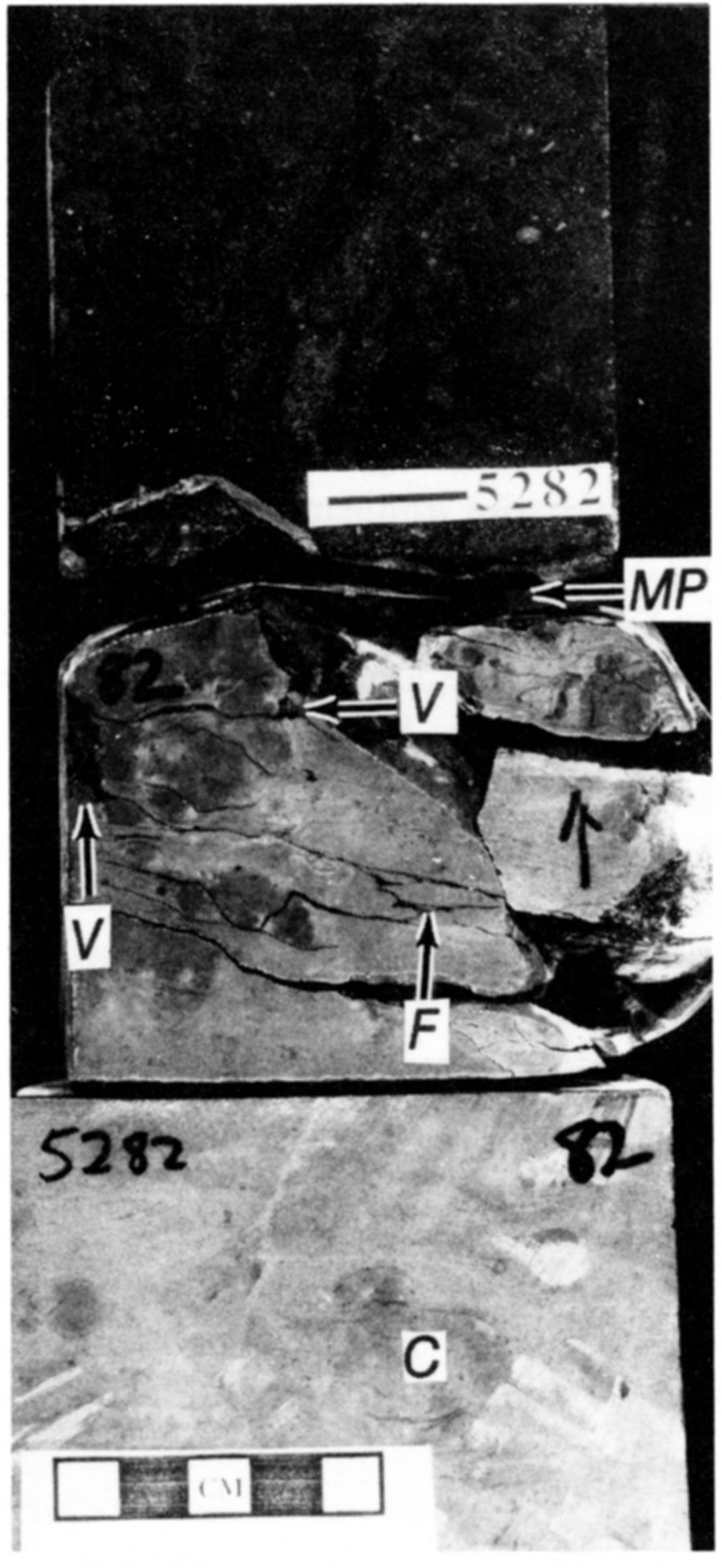
The boundary between the formations is part of a highly erosional unconformity that separates the Mississippian and Pennsylvanian systems over much of North America. The upper beds of the Shore Airport become increasingly eroded northward until erosion associated with the sub-Pennsylvanian unconformity has removed the formation entirely (fig. 1). Rare reworked lithoclasts of the Shore Airport are part of a thin transgressive lag at the base of the Kearny in the type section. Shore Airport strata up to 6 em beneath the subPennsylvanian unconformity contain solution-enlarged fracture and vuggy porosity filled with shaly, skeletal sandstones of Morrowan age (fig. 15). The sediment-filled porosity is interpreted as microkarst formed during Late Mississippian-Early Pennsylvanian subaerial exposure. Light-brown calcareous nodules occur up to 1.2 ft (0.4 m) below the subPennsylvanian unconformity. These nodules show only minor compaction and contain rhizoliths, microspar, and approximately 10% detrital quartz. Greenish clay-filled fractures occur from 5,282.6 ft, 0.5 ft (0.2 m) below the unconformity, down to 5,284.7 ft; they are bordered by greenish halos. These fractures are interpreted as illuviation cutans (table 1) formed by clay that is washed into cracks (cf. Retallack, 1990). The calcareous nodules and illuviation cutans probably formed during Late Mississippian-Early Pennsylvanian subaerial exposure because they are best developed proximal to the sub-Pennsylvanian unconformity and are not well developed in any Shore Airport paleosols.
Where Morrowan strata are absent, the Shore Airport is overlain by the informal "Gray group" (Atokan") (cf. Youle, 1991) and locally by the Cherokee Group (Desmoinesian) (Goebel and Stewart, 1979). Compared to Shore Airport strata, "Gray group" limestones are typically cleaner and are commonly interstratified with more radioactive shales. Log signatures of the Cherokee Group appear similar to strata of the "Gray group" but are typically more thinly bedded (Youle, 1991).
Figure 15—Mississippian-Pennsylvanian Unconformity (MP) at 5,282.05-ft core depth in the Shore Airport type section. Solution-enlarged fractures (F) and vuggy (V) porosity are filled with Morrowan sediment indicating microkarstification. Underlying Shore Airport has calcareous nodules (C) and greenish clay-filled illuviation cutans (not shown) that decrease in abundance from the unconformity and are not present in other Shore Airport paleosols. 5,181-5,182-ft core depth. Amoco #1 Breeding F.
Lateral Variability
Very few cores of the Shore Airport are available for study. The majority of these cores are short, many only targeting the sandstone at the base of the unit in Seward and surrounding counties. Therefore, evidence of lateral variability of the Shore Airport relies heavily on log stratigraphic cross sections.
Maximum observed thickness of the Shore Airport Formation is 446 ft (136 m) in southwestern Meade County. Thickness of the Shore Airport changes dramatically, largely in response to erosion associated with the sub-Pennsylvanian unconformity. In extreme southwestern Seward County, the thickness of the Shore Airport changes by as much as 247 ft (75 m) between two wells approximately 7 mi (11 km) apart. A structural cross section indicates this thickening of the Shore Airport is the result of erosion over a structural high.
Sandstones at the base of the Shore Airport are productive in Stevens, Seward, and Haskell counties (Clair, 1948, 1949; Veroda, 1959; Fugitt and Wilkinson, 1959; Shonfelt, 1988). Basal Shore Airport sandstone, lirnestone-lithoclast conglomerate, and coaly shale are present in Stevens County in cores from the Anadarko #2 Hitch G (sec. 3, T. 33 S., R. 34 W.), Anadarko #2 Etzold B (sec. 22, T. 33 S., R. 34 W.) and Anadarko #3 Cosgrove A (sec. 22, T. 33 S., R. 34 W.). These three basal Shore Airport and Ste. Genevieve cores are currently stored at the Kansas Geological Survey core facility.
Because Shore Airport cores are generally absent, lateral variability relies heavily on the calibration of logs to lithologies in the Amoco #1 Breeding F. These interpretations of log patterns are probably not unique solutions. Cuttings would be effective in calibrating these log patterns to lithologies throughout southwestern Kansas. Fragments of many paleosol features should be recognizable in cuttings, especially if thin sectioned.
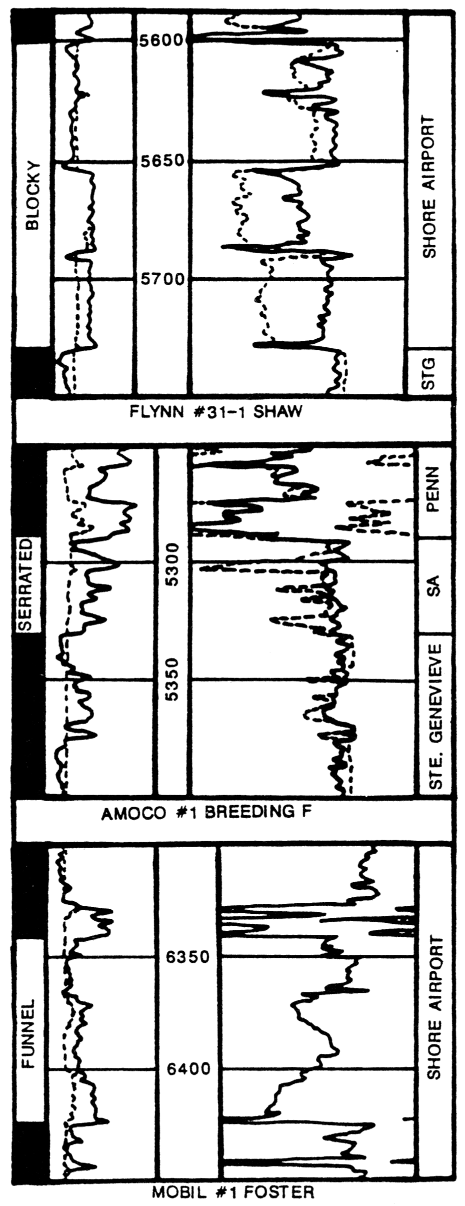
Three log profiles are recognized in Shore Airport carbonates: I) serrated, 2) blocky, and 3) funnel (fig. 16). Some of these names are borrowed from descriptive shapes of spontaneous potential curves (cf. Doveton, 1986). Serrated profiles are common and are well illustrated in the Amoco #1 Breeding F (fig. 6). Serrated profiles are interpreted as argillaceous limestones punctuated by alfisol clay-rich (B,) soil horizons. It is likely, however, that not all the shales in the Shore Airport are paleosols. Thick intervals that lack interbedded shales produce blocky profiles. Blocky profiles are common and are interpreted as successions of argillaceous limestones that lack interbedded clay-rich (B,) soil horizons. Blocky profiles may be punctuated by entisols or inceptisols. Blocky profiles are well illustrated in many well (e.g. Douglas #1-18 Thomas, sec. 18, T. 34 S., R. 35 W.). Funnel profiles are rare in most Shore Airport sections. Mobil #1 Foster (sec. 5, T. 34 S., R. 36 W.) illustrates several funnel profiles. Funnel profiles are difficult to interpret because they have not been calibrated to core lithologies, but they may represent shoaling-upward cycles from argillaceous peloid packs tones to high-energy peloid ooid grainstones.
Blocky and serrated types commonly occur in the same well. Serrated profiles are most abundant in Morton County. To the east, blocky profiles become more abundant. Funnel profiles occur locally. This trend in log patterns may suggest that the Shore Airport in Morton County contain numerous alfisols, and successions that lack paleosols or are punctuated by entisols and inceptisols (clay-poor paleosols) become more abundant eastward. Additional work on Shore Airport lateral variability is needed.
Figure 16—Log profiles observed in the Shore Airport in southwestern Kansas. Serrated profiles are interpreted to result from subtidal peloid packstones punctuated by clay-rich alfisols. Blocky profiles are interpreted to result from subtidal strata, possibly punctuated by clay-poor entisols or inceptisols. Peloid packstones with entisols from the upper Ste. Genevieve result in a log pattern similar to observed blocky profiles. Funnel profiles have not been observed in core, but may represent high-energy shoaling-upward cycles from argillaceous peloid packstone to peloid ooid grainstone.
Sedimentology
Shore Airport strata cap an overall regressive sequence that was deposited during the Late Mississippian. In southwestern Kansas, Meramecian strata generally consist of middle to outer shelf deposits consisting largely of normal-marine limestones. The uppermost Meramecian and Chesterian strata contain increasing influence of eolian depoition and paleosol formation. Subtidal intervals are typically thin and consist largely of oolitic grainstone and peloid packstone. Relative sea-level rises in the Late Mississippian rarely flooded this portion of the shelf completely enough to deposit widespread normal normal-marine limestones.
Asquith (1984) reports crinoid-bryozoan wackestone and packstone and porous oolitic grainstone from the Chesterian of north western Oklahoma. Normal-marine limestone in northwestern Oklahoma may be correlative to restricted peloid packstone in southwestern Kansas. Oolitic shoals may have been barriers to circulation with open-marine waters to the south. Alternatively, restricted conditions may be the result of poor circulation across a shallow shelf. Biostratigraphy and correlation of paleosols (sequence stratigraphy) is needed to help determine facies transitions in the Shore Airport.
Conclusions
- The Shore Airport Formation in the Hugoton embayment of the Anadarko basin is a new stratigraphic unit for previously unnamed Chesterian strata. The Shore Airport-Ste. Genevieve boundary is defined at the top of the uppermost quartzose grainstone. Overlying Pennsylvanian strata typically have an increased siliciclastic fraction relative to Shore Airport strata. The Shore Airport Formation is named for the Shore Airport SW 7.5-minute quadrangle, Morton County, Kansas. The type section is a core from the Amoco #1 Breeding F (sec. 34, T. 31 S., R. 40 W.) that contains 40.6 ft (12.4 m) of Shore Airport strata. Peloid packstone and maroon calcareous shale are the two facies recognized from the type section of the Shore Airport.
- Peloid packstone is greenish-gray to maroon in color and is the dominant facies. Paucity of stenohaline marine allochems, fine grain size, and micrite matrix indicate deposition in a low-energy, restricted shelf environment. Local winnowing and rare ooids suggest waters were periodically agitated. Maroon color formed by illuvial accumulation of sesquioxides in a Bs soil horizon.
- Peloid packstone is intercalated with maroon calcareous shales. Clay and sesquioxides accumulated in the Bt horizon. Slickensides, glaebules, drab-haloed root traces, rhizocretions, and blocky peds indicate these reddish intervals are paleosols.
- Two types of paleosols are present in the Shore Airport Formation in the Amoco #1 Breeding F. Inceptisols are marked by sesquioxide-rich Bs horizons that contain little clay. Alfisols are marked by sesquioxide-rich and clay-rich Bs horizons. Paleosols are spaced 2.8-10.8 ft (0.9-3.3 m) apart and are interstratified with restricted peloid packstone.
Acknowledgments
Amoco Production Company graciously donated the Amoco #1 Breeding F core to the Kansas Geological Survey for use as a type section for the Shore Airport. I would like to thank Amoco Production Company and the Kansas Geological Survey for providing access to numerous Upper Mississippian cores. Thanks are extended to Amoco's Van Leighton for his kind assistance and consideration.
Chris Maples deserves special acknowledgment for suggesting I undertake this project. His editorial remarks improved this report greatly. This study is an extension of a dissertation at the University of Kansas under the direction of Paul Enos. I would like to thank Paul for his guidance and input. His editorial comments and suggestions significantly strengthened this paper. Tom Thompson graciously reviewed this paper. Kevin Evans, John Youle, Greg Retallack, and Thomas Ahlbrandt contributed to discussions that improved ideas used in this report. Michelle Abegg assisted in some of the word processing and computer drafting for this report.
Research on Upper Mississippian strata has been supported by the Geology Associates Program of the University of Kansas Endowment Association, the Kansas Geological Survey, Amoco Production Company, and Phillips Petroleum Company.
References
Abegg, F. E., 1991, Sedimentology and lithostratigraphy of the Upper Mississippian Ste. Genevieve and St. Louis Limestones, southwestern Kansas; in, Integrated Studies of Petroleum Reservoirs in the Midcontinent, W. L. Watney, A. W. Walton, C. D. Caldwell, and M. K. Dubois, organizers: American Association of Petroleum Geologists, Midcontinent Meeting Core Workshop, p. 1-33
Abegg, F. E., 1992, Lithostratigraphy, depositional environments, and sequence stratigraphy of the Ste. Genevieve and St. Louis Limestones (Upper Mississippian), southwestern Kansas: Ph.D. dissertation, The University of Kansas, Lawrence, p.
Asquith, G. B., 1984, Depositional and diagenetic history of the Upper Chester (Mississippian) oolitic reservoirs, north-central Beaver County, Oklahoma; in, Limestones of the Midcontinent, N. J. Hyne, ed.: Tulsa Geological Society, Special Publication No.2, p. 87-92
Beebe, B. W., 1959a, Characteristics of Mississippian production in the northwestern Anadarko basin: Tulsa Geological Society, Digest, v. 27, p. 190-205
Beebe, B. W., 1959b, Characteristics of Mississippian production in the northwestern Anadarko basin; in, Proceedings of the Sixth Biennial Geological Symposium, C. A. Moore, ed.: The University of Oklahoma, Norman, p. 176-196
Brewer, R., 1976, Fabric and mineral analysis of soils: John Wiley & Sons, New York, 470 p.
Clair, J. R., 1948, Preliminary notes on lithologic criteria for identification and subdivision of the Mississippian rocks in western Kansas: Kansas Geological Society, 14 p.
Clair, J. R., 1949, Lithologic criteria of Mississippian rocks in western Kansas: World Oil, p. 61-66 .
DeVoto, R. H., 1980, Mississippian stratigraphy and history of Colorado; in, Colorado Geology, H. C. Kent and K. W. Porter: Rocky Mountain Association of Geologists, Denver, p. 57-70
Dille, G. S., 1932, Symposium on western Oklahoma, summaries and abstracts of technical papers: Tulsa Geological Society, p.
Dodd, J. R., and Stanton, R. J., 1981, Paleoecology, concepts and applications: John Wiley & Sons, New York, 559 p.
Doveton, J. H., 1986, Log analysis of subsurface geology, concepts and computer methods: John Wiley & Sons, New York, 273 p.
Dunham, R. J., 1962, Classification of carbonate rocks according to depositional texture; in, Classification of Carbonate Rocks—A Symposium, W. E. Ham, ed.: American Association of Petroleum Geologists, Memoir 1, p. 108-121
Ebanks, W. J., Brady, L. L., Heckel, P. H., O'Connor, H. G., Sanderson, G. A., West, R. R., Wilson, F. W., 1979, The Mississippian and Pennsylvanian (Carboniferous) Systems in the United States—Kansas: U.S. Geological Survey, Professional Paper 1110-Q, 30 p. [available online]
Frezon, S. E., and Jordan, L., 1979, Oklahoma; in, Part I, Introduction and Regional Analyses of the Mississippian System, L. C. Craig and C. W. Connor, eds.: U.S. Geological Survey, Professional Paper 1010, p. 147-159 [available online]
Fugitt, L. B., and Wilkinson, R. D., 1959, Eubank field; in, Kansas Oil and Gas Fields, v. II, Western Kansas: Kansas Geological Society, p. 13-20
Glick, E. E., 1979, Arkansas; in, Part I, Introduction and Regional Analyses of the Mississippian System, L. C. Craig and C. W. Connor, eds.: U.S. Geological Survey, Professional Paper 1010, p. 124-145 [available online]
Goebel, E. D., 1968, Mississippian rocks of western Kansas: American Association of Petroleum Geologists, Bulletin, v. 52, p. 1,732-1,778
Goebel, E. D., and Stewart, G.F., 1979, Kansas; in, Part I, Introduction and Regional Analyses of the Mississippian System, L. C. Craig and C. W. Connor, eds.: U.S. Geological Survey, Professional Paper 1010, p. 115-123 [available online]
Goldhammer, R. K., and Elmore, R. D., 1984, Paleosols capping regressive carbonate cycles in the Pennsylvanian Black Prince Limestone, Arizona: Journal of Sedimentary Petrology, v. 54, p. 1,124-1,137
Handford, C. R., 1988, Review of carbonate sand-belt deposition of ooid grains tones and application to Mississippian reservoir, Damme field, southwestern Kansas: American Association of Petroleum Geologists, Bulletin, v. 72, p. 1,184-1,199
Handford, C. R., 1990, Mississippian carbonate eolianites in southwestern Kansas (abs.): American Association of Petroleum Geologists, Bulletin, v. 74, p. 669
Handford, C. R., and Francka, B. J., 1991, Mississippian carbonate-siliciclastic eolianites in southwestern Kansas; in, Mixed Carbonate-siliciclastic Sequences, A. J. Lomando and P. M. Harris, eds.: Society of Economic Paleontologists and Mineralogists, Core Workshop No. 15, p. 205-243
Hausenbuiller, R. L., 1978, Soil science: Wm. C. Brown Company Publishers, Dubuque, Iowa, 611 p. .
Hunter, R E., 1977, Basic types of stratification in small eolian dunes: Sedimentology, v. 24, p. 361-387
Hunter, R E., 1981, Stratification styles in eolian sandstones-some Pennsylvanian to Jurassic examples from the Western Interior, U.S.A.; in, Recent and Ancient Nonmarine Depositional Environments-Models for Exploration, F. G. Ethridge and R. M. Flores, eds.: Society of Economic Paleontologists and Mineralogists, Special Publication 31, p. 315-329
Hunter, R E., 1989, Eolianites in the Ste. Genevieve Limestone of southern Indiana: American Association of Petroleum Geologists, Eastern Section Meeting Guidebook, 19 p.
Klappa, C. F., 1978, Biolithogenesis of Microcodium—elucidation: Sedimentology, v. 25, p. 489-522
Klappa, C. F., 1980, Rhizoliths in terrestrial carbonates—classification, recognition, genesis, and significance: Sedimentology, v. 27, p.613-629
Kocurek, G., 1991, Interpretation of ancient eolian sand dunes: Annual Review of Earth and Planetary Sciences, v. 19, p. 43- 75
Kocurek, G., and Dott, R. H., 1981, Distinctions and uses of stratification types in the interpretation of eolian sand: Journal of Sedimentary Petrology, v. 51, p. 579-596
Lane, H. R., and DeKeyser, T. L., 1980, Paleogeography of the late Early Mississippian (Tournaisian 3) in the central and southwestern United States; in, Paleozoic Paleogeography of the West-central United States, T. D. Fouch and E. R. Magathan, eds.: Rocky Mountain Society of Economic Paleontologists and Mineralogists, p. 149-162
Lee, W., 1940, Subsurface Mississippian rocks of Kansas: Kansas Geological Survey, Bulletin 33, 114 p. [available online]
Maples, C. G., and Waters, J. A., 1987, Redefinition of the Meramecian/Chesterian boundary (Mississippian): Geology, v. 15, p. 647-651
McClellan, H. W., 1930, Subsurface distribution of pre-Mississippian rocks of Kansas and Oklahoma: American Association of Petroleum Geologists, Bulletin, v. 14, p. 1,535-1,556
Merriam, D. F., 1963, The geologic history of Kansas: Kansas Geological Survey, Bulletin 162, 317 p. [available online]
Retallack, G. J., 1988, Field recognition of paleosols; in, Paleosols and Weathering through Geological Time-Principles and Applications, J. Reinhardt and W. R. Sigleo, eds.: Geological Society of America, Special Paper 216, p. 1-20
Retallack, G. J., 1990, Soils of the past, an introduction to paleopedology: Unwin Hyman, Boston, 520 p.
Shonfelt, J. P., 1988, Geological heterogeneities of a Chesterian sandstone reservoir, Kinney-lower Chester Field, Stevens and Seward counties, Kansas, and their effect on hydrocarbon production: M.S. thesis, Wichita State University, Kansas, p.
Swanson, D. C., 1978, Deltaic deposits in the Pennsylvanian upper Morrow Formation of the Anadarko basin; in, Pennsylvanian Sandstones of the Midcontinent, N. J. Hyne, ed.: Tulsa Geological Society, Special Publication Number 1, p. 115-168
Thompson, T. L., 1986, Paleozoic succession in Missouri, Part 4, Mississippian System: Missouri Geology and Land Survey, Report of Investigation Number 70, 182 p.
Thompson, T. L., and Goebel, E. D., 1968, Conodonts and stratigraphy of the Meramecian Stage (Upper Mississippian) in Kansas: Kansas Geological Survey, Bulletin 192, 56 p. [available online]
Veroda, V. J., 1959, Mississippian rocks of southwest Kansas; in, Proceedings of the Sixth Biennial Geological Symposium, C. A. Moore, ed.: The University of Oklahoma, Norman, p. 143- 175
Youle, J. C., 1991, Sequence stratigraphy of the lower Middle Pennsylvanian in the eastern Hugoton embayment of southwestern Kansas; in, Integrated Studies of Petroleum Reservoirs in the Midcontinent, W. L. Watney, A. W. Walton, C. D. Caldwell, and M. K. Dubois, organizers: American Association of Petroleum Geologists, Midcontinent Meeting Core Workshop, p. 144-172
Prev Page--Lorton Coal Bed || Next Page--Hugoton and Stevens Members
Kansas Geological Survey, Geology
Placed on web Nov. 29, 2018; originally published April 1994.
Comments to webadmin@kgs.ku.edu
The URL for this page is http://www.kgs.ku.edu/Publications/Bulletins/230/05_shore.html