![]()
Prev Page--Virgilian Series || Next Page--Shore Airport Formation
A Reference Section for the Pennsylvanian Lorton Coal Bed (Root Shale: Wabaunsee Group) in Kansas
by Lawrence L. Brady and Christopher G. Maples
Abstract
The Lorton coal bed (Wabaunsee Group: Virgilian) of Late Pennsylvanian age is formally recognized as a bed-level stratigraphic unit in the Root Shale in Kansas. A stratigraphic reference section in Lyon County, Kansas, is given for the Lorton coal bed.
Introduction
The Wabaunsee Group (Pennsylvanian:Virgilian) in Kansas is notable for its general historical lack of coal-mining activity compared with older, Desmoinesian coals of the Cherokee Group. Over the years, the most consistently mined coal from the Wabaunsee Group in Kansas has been the Nodaway coal bed (Howard Limestone). Whitla (1940) and Schoewe (1946) provided excellent summaries of mining efforts and nomenclatural histories for many of the Wabaunsee Group coal beds.
During work on a stratigraphic lexicon for the state of Kansas, it became apparent that the informally named Lorton coal in the Wabaunsee Group was laterally extensive enough to form a coal horizon of stratigraphic importance and sufficiently easy to recognize to justify formal bed status. It is the purpose of this paper to assign formal bed status to the Lorton coal bed in the upper part of the Root Shale. In addition, a measured reference section of the Lorton coal bed in Kansas is given.
Lorton Coal Bed
The Lorton coal bed has been well known in an informal sense in Kansas for most of this century. Moore (1935 [1936], p. 240) noted that the Lorton coal bed was one of the most persistent and well-known late Paleozoic coal beds in the midcontinent, with exposures from Oklahoma to Nebraska. Schoewe (1946, p. 49) noted that the Lorton coal was one of the few Wabaunsee Group coals that had been mined in more than one county (Greenwood, Pottawatomie, Lyon, and Wabaunsee). In Nebraska, the Lorton Coal, one of only three Wabaunsee Group coals formally recognized (Burchett, 1977, p. 23), occurs in the French Creek Shale Member (Root Shale), immediately below the Nebraska City Limestone Member of the Wood Siding Formation.
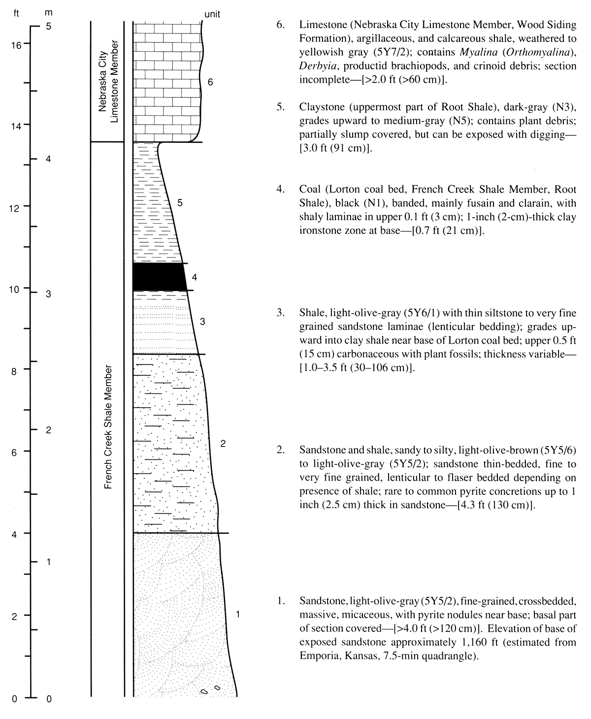
The Lorton coal bed can be observed in Kansas where the upper IO-ft (3-m) interval of the Root Shale (= French Creek Shale Member) is exposed. Overlying the Root Shale is the Nebraska City Limestone Member of the Wood Siding Formation. The Lorton coal bed commonly is at least 1-3 inches (2-8 cm) thick throughout the outcrop belt of the Root Shale in Kansas, however a maximum thickness of 17 inches (43 ern) has been reported for the Lorton coal bed in Lyon County, Kansas (Schoewe, 1946, p. 100-102). Mohler (1891) reported a coal in Greenwood County near the Greenwood-Lyon County line that was 37 inches (94 cm) thick, which was noted by Schoewe (1946, p. 93) as possibly being the Lorton coal. We selected a reference section for the Lorton coal bed in Kansas along the Kansas Turnpike in Lyon County, Kansas (figs. 1 and 2), because of the unusually good quality of this exposure (which generally is poor in the Root Shale), ease of accessibility, and typical thickness for the Lorton coal bed (fig. 3).
Figure 1—Locality of Lorton coal bed reference section near road marker 129, along northwest side of Kansas Turnpike (NE SW sec. 32, T. 18 S., R. II E.), Lyon County, Kansas (Emporia, Kansas, 7.5-min quadrangle).
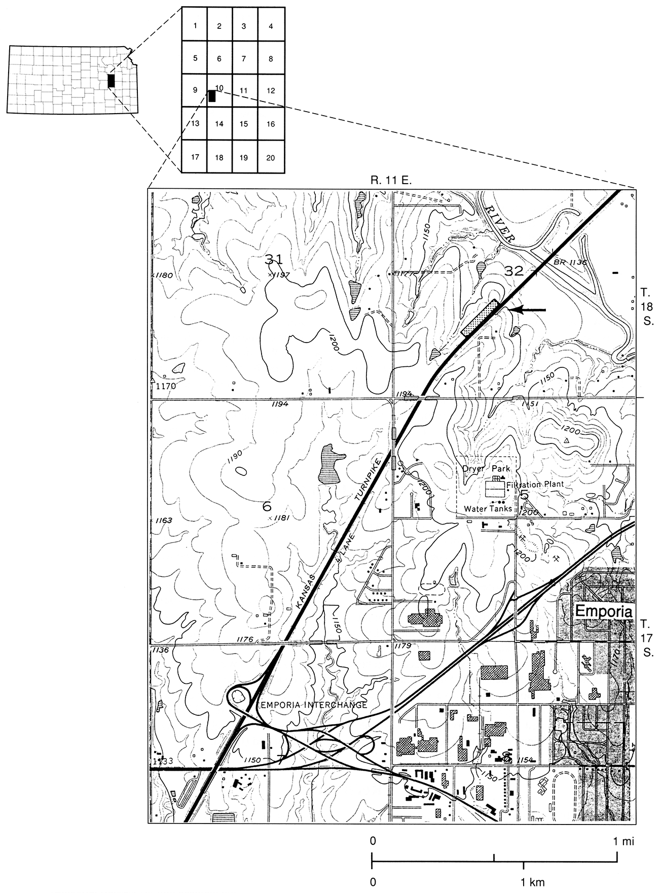
Figure 2—L. L. Brady indicates the base of the Lorton coal bed at its principal reference section in Lyon County. Note the crossbedded sandstone (unit 1 in fig. 3) at the base of the exposure.
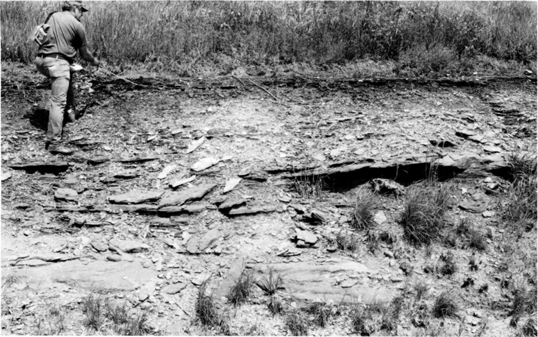
Figure 3—Reference section for the Lorton coal bed in Kansas.
References
Burchett, R. R., 1977, Coal resources of Nebraska: Nebraska Geological Survey, Resource Report No. 8, 183 p.
Mohler, M., 1891, Kansas State Board of Agriculture, 7th Biennial Report: Kansas State Board of Agriculture, part 1, p. 1-282
Moore, R. C., 1935 [1936], Stratigraphic classification of the Pennsylvanian rocks of Kansas: Kansas Geological Survey, Bulletin 22, 256 p. [available online]
Schoewe, W. H., 1946, Coal resources of the Wabaunsee Group in eastern Kansas: Kansas Geological Survey, Bulletin 63, 144 p. [available online]
Whitla, R. E., 1940, Coal resources of Kansas-post-Cherokee deposits: Kansas Geological Survey, Bulletin 32, 64 p. [available online]
Prev Page--Virgilian Series || Next Page--Shore Airport Formation
Kansas Geological Survey, Geology
Placed on web Nov. 29, 2018; originally published April 1994.
Comments to webadmin@kgs.ku.edu
The URL for this page is http://www.kgs.ku.edu/Publications/Bulletins/230/04_lorton.html