![]()
Prev Page--Introduction || Next Page--Geology--Lansing-Kansas City, Permian
Geology
General
The Gorham oil field is localized by a lO-mi (16- km)-long northwest-trending anticline structurally controlled by block faulting in the Precambrian granite basement rocks. Cambrian Reagan Sandstone and Ordovician Arbuckle dolomite, thickness to 400 ft (120 m), are truncated to a thin edge and are absent on the upfaulted Precambrian high. Oil in the Arbuckle dolomite-Reagan Sandstone reservoir, the principal oil reservoir of the Gorham oil field, is associated with the pre-Pennsylvanian unconformity surface, depths near 3,300 ft (990 m). At the more shallow depths of 3,000-3,300 ft (900-990 m), Lansing-Kansas City limestones are draped over the major anticline and over local highs forming separate anticlinal oil reservoirs. The basement block faulting influences all the overlying sedimentary rocks of Pennsylvanian, Permian, and Cretaceous age, in diminishing amounts upward. The near-surface Fence-post limestone has 30 ft (9 m) of anticlinal closure, on which the 1926 discovery well of the Gorham oil field was located.
Cross section A-B-C
The overall relationship of the block-faulted basement rocks to the 3,300-3,700 ft (990-1,110 m) of overlying sedimentary rocks is demonstrated by cross section A-B-C, in two parts, figs. 5 (A-B) and fig. 6 (B-C). The cross section extends 14 mi (22.4 km) from southwest to northeast across the Gorham oil field as shown in fig. 3. The holes providing information used in constructing the cross section numbered consecutively from 1 to 53 are listed in the appendix, table 3, with pertinent information.
Figures 5 and 6--Cross section A-B-C, extending 14 mi (22 km) from southwest to northeast across the Gorham oil field; for location, see fig. 3. Control test holes numbered 1-53 are listed in the appendix, table 3. Solid dots indicate oil or oil-production zones. Open circles indicate water, usually showing the positions of aquifers from which water was recovered in test holes drilled with the now-obsolete cable tools. The vertical exaggeration x13.2 causes dips in the Arbuckle beds to be oversteepened. Actual dips range from 1/4 of 1° to 2°. Descriptive terms below the cross section such as "karst lowland," "solution valley," etc., refer to the now-buried topography of the former prePennsylvanian land surface, depths near and above sub-sea minus 1,500 ft in the cross section. The single fault between miles 3 and 4 is a zone of faulting in the granite basement rocks.
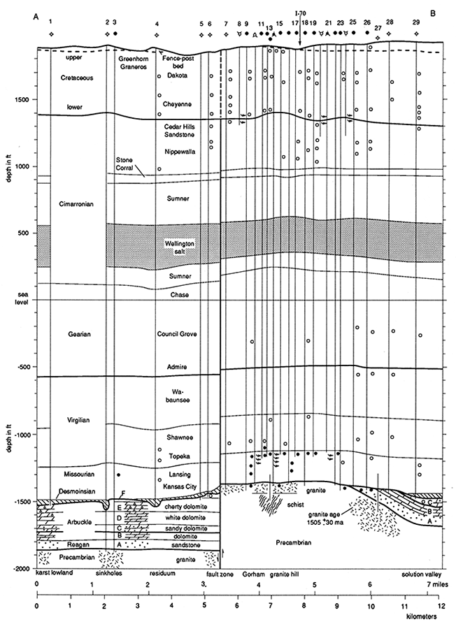
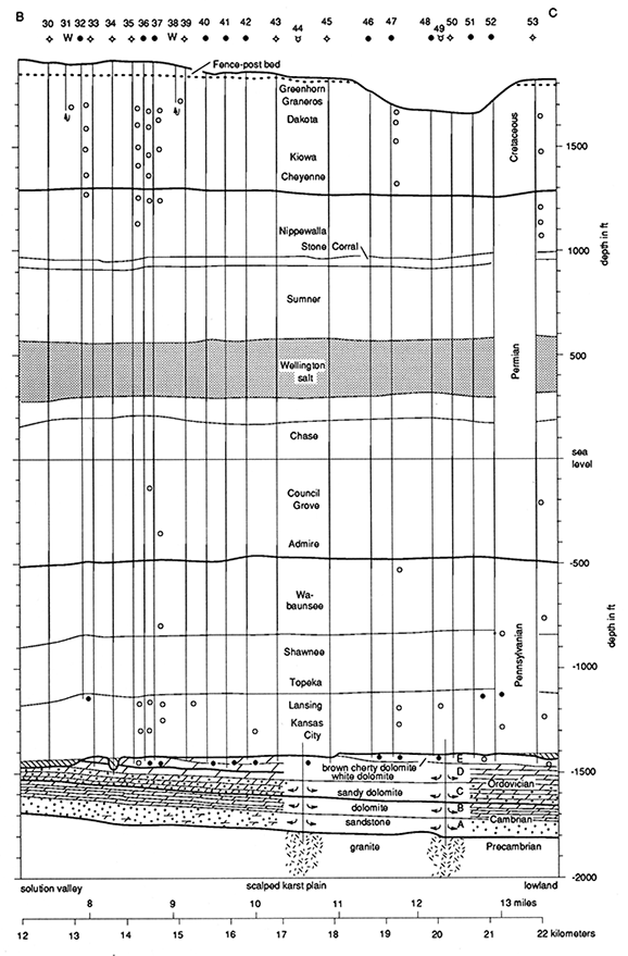
The cross section is based on many holes drilled with cable tools. These provide information on depths at which water was encountered as indicated by open circles within the body of the cross section. Where oil in commercial amounts was produced, solid dots are plotted at depths on the cross section. Arrows indicate water-flow direction. In the freshwater supply wells 31 and 38, the arrows point toward the well bore. In shallow saltwater-disposal wells 8, 20, and 24, the arrows indicate injected waste saltwater flowing outward from the well bores into the porous formations. Lower in the cross section, wells 10, 13, and 21 are saltwater-injection (SWI) wells. In them, the outward-pointing arrows indicate where saltwater under pressure was introduced into the Lansing-Kansas City limestones in formerly oil-productive zones as part of a secondary-recovery project by waterflood. Deep saltwater-disposal wells (SWD) 44 and 49 have arrows depicting outward flows of large amounts of waste oil-field brines that were produced along with the oil and disposed of by gravity flow into porous Arbuckle dolomites, sandy dolomites, and sandstones.
The prominent fault shown between miles 3 and 4 affects all formations from the Precambrian to the outcropping Cretaceous Fence-post limestone in progressively lesser amounts upward. Although shown as a single nearly vertical fault, a zone of faulting almost certainly exists at least within the Precambrian rocks. Southwest (left) of the fault, on the downthrown side, Arbuckle beds 390 ft (117 m) thick are known from wells 2 and 3.
Another structural feature is the sub-Pennsylvanian surface, identified as an unconformity surface by the angular truncation of underlying Arbuckle beds. For an extended time period (denoted by the absence of Middle and Upper Ordovician, Silurian, Devonian, Mississippian, and Lower Pennsylvanian beds), this unconformity surface was a land surface subject to weathering, principally by dissolution of the soluble Arbuckle dolomite. The buried paleokarst features of sinkholes (wells 2, 4, and 34), the scalped sinkhole-free plain (miles 9 through 13), and the low areas with regional regolith of weathered, leached residuum of Arbuckle dolomite at miles 0 to 3, wells 1 to 6, and wells 29, 30, and 53, are all evidence of a buried paleokarst topographic surface. The extensive unconformity-related oil reservoir in the Arbuckle dolomite and Reagan Sandstone is shown in figs. 5 and 6 by the numerous solid dots denoting oil production.
The Lansing-Kansas City beds over the local high, mile 1, and the regional high, miles 4 to 6, are local, anticlinal closures that form separate traps for oil in the porous Lansing-Kansas City limestones. Solid dots within the Lansing-Kansas City interval near mile 1 and miles 4, 5, 6, 8, and 13 indicate commercial oil production.
Higher in the section, the Hutchinson Salt Member of the Wellington Shale thins appreciably over both the regional high, miles 3-6, and the local high, mile 1. At still more shallow depths is the unconformity between the Permian and Cretaceous rocks. It has irregularities, only partly structural, including residual topography controlled by resistant lithology.
The cross sections indicate that the effects of the prominent basement fault are still manifest at the present land surface. Near-surface structural closure directly above the upfaulted granite was mapped at the time of the discovery of the Gorham oil-field anticline and confirmed by shallow core drilling to the Fence-post bed at depths of about 60 ft (18 m).
Cross sections A-B and B-C are drawn with a vertical exaggeration x13.2. One effect of this is to increase the apparent dips on the cross section. For example, the slope on the Precambrian surface between miles 6 and 7 is drawn as 26° and the dip in the bedding of the Arbuckle is drawn as 22°. Actually the Precambrian surface slopes 200 ft (60 m) toward the northeast in 1 mi (1.6 km). This is a slope of a little over 2°. (A dip or slope of 91 ft in 1 mi [27 mi/km] equals 1° angle.) The overlying Arbuckle beds dip 175 ft northeastward in 1 mi (52.5 mi/km) or an actual dip of a little under 2°. Elsewhere, they are nearly flat, dipping only 25 ft per mile (7.5 mi/km) or one-fourth of 1°.
Map series
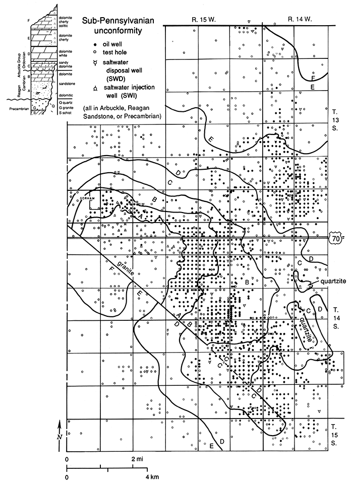
Each map in the series of geological maps shows as control points only those test holes deep enough to reach the subsurface unit mapped, eliminating shallower tests. For example, the map of the Precambrian rocks, depth 3,300-3,700 ft (990-1,110 m; fig. 7), shows only those wells deep enough to penetrate into the Precambrian rocks. All more shallow test holes are eliminated. The 14 solid dots in fig. 7 indicate wells which produced oil from the Precambrian granite or quartzite.
In the series of maps, no distinction is made between oil wells active as of December 31,1986, and oil wells abandoned prior to that date. All test holes drilled to or through the surface, zone, or unit mapped, which are not definitely known to produce oil from that interval, are shown as open circles regardless of whether they mayor may not have produced oil from either shallower or deeper zones. There are no wells producing only gas.
Even with this simplification, it is difficult to present the geologic maps on a single page because of the unusually large area, approximately 100 mi2 (260 km2) depicted on each map, and because of the close spacing of wells that were commonly drilled on 10-acre (4-hectare) locations in the older portion of the oil field. Some areas have been redrilled on 5- acre (2-hectare) spacing or as twin or even triple holes at one location. Many abandoned holes were reentered at a later date, often by a different operator. About 5% of the total reported drilling in the 1980's consisted of such reentry.
Precambrian basement rocks
Structure
The igneous and metamorphic basement rocks underlying the Gorham oil field are Precambrian in age. The basement-rock surface is mapped in fig. 7 with a contour interval of 100 ft (30 m). Only those tests actually penetrating Precambrian rocks are illustrated. Over 300 shallower wells (not shown) penetrating only part way through the Arbuckle Group were used for estimating depths to the Precambrian. The author's own identification of the stratigraphic position within the Arbuckle Group by examination of samples of well cuttings and acid insoluble residues permitted him to estimate the depth to basement. This method was used almost exclusively to map the southwest flank of the Gorham anticline. Only six holes were actually drilled into the Precambrian rocks southwest of the Gorham oil field. Two are shown on cross section AB (fig. 5), as wells 2 and 3.
Figure 7--Precambrian structure; contour interval 100 ft (30 m) below sea level. Only control holes that drilled into Precambrian basement rocks are shown. Solid dots indicate the position of six wells near Gorham that produced oil from fresh Precambrian granite and nine wells that produced small amounts of oil from fractures in Precambrian quartzite on the summit of the Vaughn quartzite hill in T. 14 S., R. 14 W. The closely spaced contours south of the town of Gorham indicate a northwest-trending fault zone with more than 400 ft (120 m) of displacement down to the southwest. Cross faults with a northeast trend are mapped in secs. 21, 22, 27, and 28, near the center of T. 14 S., R. 15 W. Faulting is also established at the east edge of the map in T. 14 S., R. 14 W., and is probably also associated with the adjacent Vaughn quartzite hill.
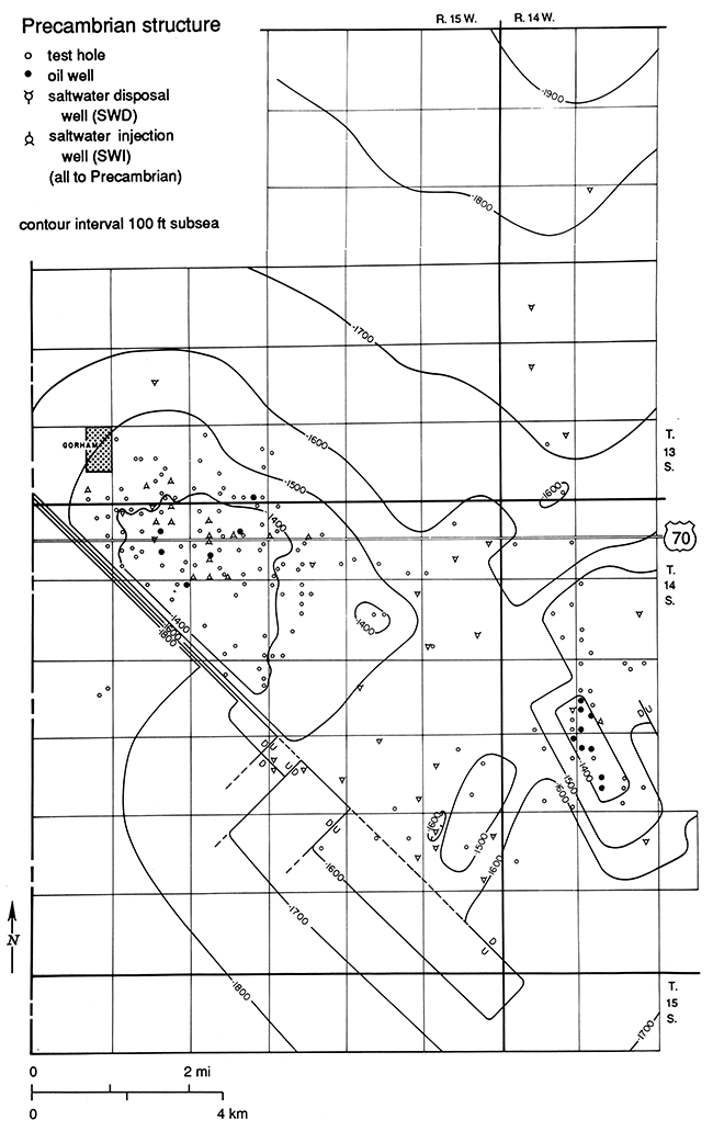
The prominent northwest-trending Gorham anticline has a relief of 400 ft (120 m) on the southwest side as shown by the 100-ft contours in fig. 7. This is interpreted as a fault or fault zone. To the northwest, beyond the area mapped, the fault zone is intersected by a north-trending basement fault zone, which marks the west side of the Fairport anticline (Cole, 1962). Toward the southeast the displacement decreases and the fault zone cannot be mapped beyond sec. 36, T. 14 S., R. 15 W. In sec. 22, T. 14 S., R. 15 W., four deep saltwater-disposal wells were reportedly drilled to the Precambrian. Records are poor and samples were not saved; nevertheless, these wells suggest northeast-trending cross faults. If control were equally abundant elsewhere, it is probable that the Precambrian basement rocks would be recognized as extensively block faulted.
Granite
The Precambrian rock most commonly encountered in the 100 mi2 (260 km2) study area is granite. Coarse quartz grains, salmon pink orthoclase feldspar, and accessory biotite characterize this typical "tombstone granite."
Farquhar (1957), in his petrographic study The Precambrian rocks of Kansas recognized two types of granite: 1) "earlier" granitic gneiss or gneissic granite-metamorphic, foliated, folded, and interbanded with metasediments, quartzite, and schists; age undated, but probably about 1,500 million years (m.y.) old; and 2) "later" intrusive granite-post metamorphic, batholithic; age undated, but younger.
In both types of granite, the principal minerals are
| Quartz | 25-30% |
| Orthoclase and microcline | 40-50% |
| Plagioclase | 20-25% |
| Muscovite | 2-3% |
| Biotite | 1-2% |
| Accessory minerals (magnetite, zircon, sphene, hornblende) | 0.5-1% |
Farquhar states that the two granites differ greatly in origin with the "later" emplaced as an igneous rock mass of batholitic proportions, whereas the "earlier" granites were intrusive into sedimentary rock and were metamorphosed along with them into a series of quartzites, schists, and granite gneisses, banded and folded together. The principal physical distinction between the two granite types is foliation, or gneissic and/ or schistose character. The small size of well cuttings, whether cable tool or rotary, usually makes distinction between the two granite types impossible, and both are here described simply as "granite."
The granite is fresh and unaltered at depth but is weathered on its upper surface due to exposure on one or more ancient land surfaces. Where weathered, the granite drills rapidly and is termed "granite wash," although it has not been transported or "washed" but is weathered in situ. This was verified in a core taken under the author's direction on Heathman Drilling Company's Polcyn #1 well, in the C SE SW SE sec. 31, T. 13 S., R. 15 W., in 1951. Farquhar (1957, p. 100 and plate 9) studied and illustrated the granite in this core, which he placed in the "earlier" granite group. He states:
A core through the Precambrian from a well in Russell County (31-13S-15W) shows weathered granite rather than granite wash. Both of these descriptions are applied frequently, and perhaps interchangeably, to the uppermost Precambrian rocks, but this core shows conclusively the nature of the rock at one particular point. The textural characteristics are retained and weathering has merely taken place in situ. The rock is strongly foliated and contains reddish feldspars in small lenses, typical of gneiss.
The Heathman Polcyn test hole from which the described core was taken is not shown on the cross section A-B (fig. 5), but could be projected into that cross section near mile 4. Note that well 13, also projected into the cross section near mile 4, encountered comparable weathered granite in the top 6 ft (1.8 m) of penetration, then 70 ft (21 m) of fresh pink biotite granite overlying 50 ft (15 m) of schistose dark-red metamorphic rock, for a total penetration of 126 ft (37.8 m) in the Precambrian. The author examined the excellent short cable-tool samples in 1942 from this well, the Stanolind No. 6 W. E. Benso in the C NW NW SW sec. 4, T. 14 S., R. 15 W.
In the years since Farquhar's study of Kansas basement rocks, extensive investigations of the Precambrian in the midcontinent have been made. These include studies by Muehlberger et al. (1966), Bickford et al. (1981), Denison et al. (1984), Berendsen and Blair (1986), Bickford et al. (1986), Van Schmus et al. (1987), and Van Schmus and Bickford (1988). The area of the Gorham oil field is within the 1,550-1,700 m.y.-old Central Plains province (Bickford et al., 1986), the loosely defined south border of which passes through central Kansas in an east-west direction. The younger Western Granite-Rhyolite province, 1,340-1,400 m.y. old, is located in southern Kansas, most of Oklahoma, and in the Texas Panhandle. None of the regional studies cited provides lithologic descriptions or age dates for Precambrian rocks within the 100-mi2 (260-km2) study area. One unpublished date for granite from within the limits of the Gorham oil field was furnished by Bickford (personal communication, 1988, sample KKSRS-573). The date is for granite from the Brougher Oil, Inc. #8 Mills-B in the C NE NE SE sec. 33, T. 13 S., R. 15 W., which penetrated 143 ft (42.9 m) into the Precambrian granite. Hand-picked cuttings from that test were analyzed at the University of Kansas as part of "Project Upper Crust." The #8 Mills-B is shown as well 27, cross section A-B (fig. 5), between miles 6 and 7. The age of the granite was determined as 1,505 ± 30 m.y., by the uranium-lead-zircon method of dating.
Quartzite
Two types of Precambrian quartzite are encountered. The first, consisting of coarse quartz grains tightly cemented by silica, is difficult to drill with rotary tools; penetrations are short. Sometimes it is even considered "impenetrable." When drilled with cable tools, the cuttings of such quartzite show the grains shattered by percussion drilling and the cuttings superficially resemble broken glass. These quartzites are encountered on the highest parts of the buried quartzite hills.
The second type of quartzite has minor amounts of light-colored mica, ferromagnesian minerals, or chlorite-weathering products. Such quartzites drill easily. The twisting action of rotary bits shucks out the quartz grains, sometimes without fracturing them. The rapid drilling rate, often unsupervised, resulted in penetrations of a hundred feet or more. Because such long penetrations sometimes show little change in lithology (Walters, 1953), these metamorphic quartzites may have steep to nearvertical dips. However, Berendsen (personal communication, 1989) notes that the Mount Simon Precambrian sediments look the same for hundreds of feet. An example of the second type of granular, speckled quartzite occurs in the Ohio Oil Company's #5 J. Harbaugh, C SE SW NW sec. 25, T. 14 S., R. 15 W. Granular schistose quartzite was drilled from 3,260 to 3,400 ft (978-1,020 m), a 140-ft (42-m) penetration with cable tools. The quartz grains show sub-parallel orientation and include black specks of magnetite. A dark, shiny, black ferromagnesian mineral is a common accessory. Clear mica fragments to 3 mm in size are present in the cuttings. The speckled granular schistose quartzites characteristically drill relatively rapidly. One mile (1.6 km) west of the J. Harbaugh #5 SWO, the Waudby #3 in the C N SE NW sec. 26, was recompleted as an SWO well in 1983. It was drilled in the Precambrian from 3,432 to 3,526 ft (1,030-1,058 m) TD in schistose quartzite for a 93-ft (28-m) penetration.
Farquhar (1957, p. 68) describes the petrography of the granular quartzites, which he calls "foliated metasediment quartzites": "The chief mineral is quartz, but almost all the samples contain some white mica to 8% by volume. Feldspar, epidote, chloritized biotite, magnetite, and graphite are present in small quantities, the dark minerals giving the rock a slightly speckled appearance."
Both granular quartzite and fractured hard quartzite occasionally serve as commercial oil reservoirs located on the summits of buried Precambrian quartzite hills. There are nine such Precambrian quartzite oil wells on the summit area of the Vaughn hill indicated by solid dots on the Precambrian map (fig. 7). On the Krug quartzite hill, four holes showed oil in the Precambrian quartzite, but no commercial production resulted.
Schist
Schist is not commonly encountered under the Gorham oil field. Schist associated with granite was encountered in the Stanolind No. 6 Benso in sec. 4, T. 15 S., R. 14 W., cross section A-B (fig. 5, well number 13). Schistose dark-red metamorphic rock 40 ft (12 m) thick was encountered under 74 ft (22 m) of fresh pink biotite granite as shown by excellent short samples of cable-tool well cuttings. In the eastern portion of the Gorham oil field, quartz muscovite schist associated with quartzite (Farquhar, 1957, p. 69) was encountered in sec. 17, T. 14 S., R. 14 W. An excellent example of Precambrian schist occurs just east of the area mapped. In sec. 21, T. 14 S., R. 14 W., Hall-Gurney oil field, biotite hornblende schist with well-developed schistosity was drilled as described and illustrated by Farquhar (1957, p. 74 and plate 3-F).
Buried Precambrian hills
As shown on the Precambrian map (fig. 7), tests that penetrated granite, and no other rock type, are abundant southeast of the town of Gorham. There the highest portion of a broad, low-relief area of upfaulted granite is defined by the subsea -l,400-ft contour. When exposed in Early Pennsylvanian time on the sub-Pennsylvanian land surface, this area was a broad flat-topped hill, for convenience named "Gorham granite hill." On this high area or buried flat-top hill, the granite itself rarely serves as a reservoir for commercial amounts of oil produced from fractures in the granite subjacent to the unconformity surface beneath the Pennsylvanian beds (Walters, 1953). Six wells, the only ones known to have produced oil from granite within the Gorham oil field, are indicated on the Precambrian map by solid dots, and three of them are also shown on the cross section (fig. 5) as wells 9, 14, and 23. Ten other holes that drilled into granite on the Gorham granite hill were reported as having noncommercial oil shows in weathered "granite wash."
A second high area on the Precambrian map is also defined by the -1,400-ft contour. It occurs in secs. 17-20, T. 14 S., R. 14 W. Here the Precambrian rocks are resistant metamorphic quartzites consisting almost entirely of coarse quartz grains with accessory black magnetite and light-colored mica. This area of quartzite is a residual hill on the Precambrian surface. Oil is produced from overlying shallower beds, principally in the Lansing-Kansas City, that are draped over the quartzite hill. This is the area of the former Vaughn oil field, now merged into the Gorham oil field. For convenience, the Precambrian hill, rising 200 ft (60 m) or more above the general level of the basement rocks, is called the "Vaughn quartzite hill." It has a steep southwest flank that is probably downfaulted but is mapped as a slope because the known 240 ft (72 m) of relief in 0.75 mi (1.2 km) is a slope of only 3.5°.
A second Precambrian buried-quartzite hill, for convenience called the "Krug hill," is located 1 mi (1.6 km) north of the Vaughn hill. On Krug hill, in sec. 8, T. 14 S., R. 14 W., Pennsylvanian beds directly overlie Precambrian quartzite identified in four test holes at depths of subsea -1,410 to subsea -1,424 ft (-423 to -427 m); hence, Krug hill is not defined on the Precambrian map by the 100-ft contour interval.
Structural control
A fundamental theme of this report is that the structural framework or position of the Precambrian basement directly affected all younger rock layers. This is true of the residual quartzite hills, the upfaulted broad granite area, and the low-lying areas. These Precambrian basement rocks, encountered at drilling depths of 3,300 ft (990 m) in the high areas to 3,700 ft (1,110 m) in the low areas, exert a controlling influence on all shallower structural features. The amount of fault displacement, 400+ ft (120+ m) at the Precambrian level on the southwest flank of the Gorham anticline, diminishes upward but is still present to the extent of 30 ft (9 m) of closure in the near surface or outcropping Fence-post limestone beds.
Cambrian Reagan Sandstone and Cambro-Ordovician Arbuckle Group
Thickness
Overlying the Precambrian basement rocks in the vicinity of the Gorham oil field are basal dolomitic sandstones, thought to be of Cambrian age, with a thickness of as much as 90 ft (27 m). These porous, permeable sandstones, together with dolomites and sandy dolomites of the Arbuckle Group, have a thickness of over 400 ft (120 m) in the Gorham area. All have been gently tilted, then truncated by one or more periods of post-Ordovician erosion as shown on cross sections A-B and B-C (figs. 5 and 6).
Acid insoluble residues
Mapping of units within the Arbuckle Group is based on the author's examination of well cuttings from 261 selected tests in the area that were drilled with cable tools. Acid insoluble residues prepared from cable-tool cuttings of the carbonate rocks were logged on a scale of 10 ft/inch (1.2 m/1 cm). This detailed study permitted recognition of five units within the Arbuckle Group and provided a basis for correlating within the Arbuckle from well to well. The recognition of these units was essential to understanding the geology of the Gorham anticline. These units are difficult or impossible to recognize in cuttings from rotary-drilled wells or from wire line logs with the usual short penetrations of the Arbuckle (under 30 ft [9 m]).
Acid insoluble residues were prepared by dissolving a small, weighed amount of well cuttings in 15% HCl acid, then weighing the dry undissolved residue. Actually, nothing is present in the acid insoluble residues that was not present in the original well cuttings but the insoluble residues of sand grains, chert, loose silicified oolites, and rare shale are more readily seen. In addition, even quite small amounts of some residue are diagnostic of certain beds. For example, near the top of the white dolomite member, which is characterized by its purity and low residue content, as much as 5% by weight of diagnostic fine druzy branching quartz crystals are present in residues, yet the quartz druze cannot be distinguished in the original dolomite cuttings. The residue work was originally undertaken seeking a correlation between recognized beds in the Arbuckle and their oil-reservoir properties. The study was tedious, slow, costly, destructive of a few ounces of samples of cuttings, and was only partly successful. Samples from modem rotary-drilled holes are not suitable material unless hand picked fragment by fragment, which introduces a bias concerning how much chert and which chert should be included. Acid insoluble residue work is no longer undertaken as part of a commercial oil-exploration program.
Correlation
The lithologic terms used to describe the various mapped Cambrian and Ordovician units in the Gorham oil field and their probable correlation with the standard named outcropping units in Missouri are shown in chart form as fig. 8. Regional correlation is hampered because essentially no fossils are preserved in these dolomites and sandstones and no unique lithologic bed, such as a volcanic ash, is present. However, the local correlations shown in fig. 8 of the Gorham oil field for the Reagan and Arbuckle beds A, B, C, 0, E, and F, with the Arbuckle beds in the Bemis oil field to the northwest and the Hall-Gurney, Kraft-Prusa, and Stoltenberg oil fields to the southeast, is consistent for 60 mi (96 km) based on the author's examination of well cuttings and acid insoluble residues (Walters, 1946, 1948, 1956). Fig. 8 is not to scale horizontally but is accurately scaled vertically to show the relative thickness of the named members. It also illustrates the regional disconformity between the Upper Ordovician Simpson shale and the Lower Ordovician Arbuckle Group.
Figure 8--Correlation of Reagan Sandstone, unit a, and Arbuckle units B, C, D, E, and F of this report with beds in other central Kansas oil fields and with formations named from Missouri outcrops. Correlations are based on the author'S acid insoluble residue and lithology studies. Vertical scale as shown, but not to scale horizontally.
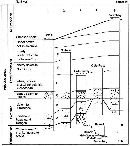
The history of attempts to correlate the subsurface Arbuckle beds of central Kansas with the much-studied outcrops and shallow subsurface in Missouri began with the work of Keroher and Kirby (1948), who made a reconnaissance study of the Arbuckle rocks in Kansas, utilizing acid insoluble residues. They examined only 24 wells in the west ranges of Kansas. None was in Russell County. They recognized that Arbuckle beds of Ordovician age overlapped Precambrian rocks and that the unit termed "sandy dolomite" in this report was deposited directly on Precambrian rocks in central Kansas, but they correlated that unit with the Roubidoux, rather than with the Gunter Formation.
McCracken (1955) correlated the upper Arbuckle beds from Missouri into central Kansas using acid insoluble residue criteria. His published cross section included the Simpson and Noble No. 1 Pulliam in sec. 35, T. 19 S., R. 8 W., in the Chase-Silica oil field, Rice County, Kansas, about 20 mi (32 km) southeast of the Stoltenberg oil field (fig. 8). Beds he designated below the Simpson shale as Cotter, Jefferson City, and Roubidoux, in downward sequence, correlate in position, thickness, and lithology with beds so named in fig. 8, column 5, Stoltenberg oil field. Chenoweth (1967) reconstructed the late Cambrian and early Ordovician history of the southern midcontinent including Kansas. He correlated the lower Ordovician Arbuckle beds in Kansas as Roubidoux, Gasconade, and Gunter, in downward sequence, overlying the Cambrian dolomites which he correlated as Eminence-Potosi. It is, therefore, probable that the central Kansas Arbuckle dolomite and the Reagan Sandstone correlations with the Missouri section are correct in fig. 8, even though correlations for 200 mi (320 km) are based on lithologic similarities and/or progressive changes in lithology unconfirmed by fossil evidence.
Information compiled in fig. 8 is derived from the following wells or composite sections:
| 1. Bemis field, Ellis County |
L. H. Wentz, #2 Fred Bemis |
C SE NE NW sec. 28, T. 11 S., R. 17 W. |
| 2. Gorham field, Russell County |
composite section |
T. 13 S., R. 14 & 15 W. T. 14 S., R. 14 & 15 W. |
| 3. Hall-Gurney, Russell County |
Empire, A-3 Krug |
C NE NW NW sec. 24, T. 15 S., R. 14 W. |
| 4. Kraft-Prusa, Barton County |
composite section |
T. 16 S., R. 11 & 12 W. T. 17 S., R. 11 & 12 W. |
| 5. Stoltenberg, Ellsworth County |
Magnolia, #6 Schroeder |
C E NW SW sec. 26, T. 16 S., R. 10 W. |
The lithologic descriptive names and the letters A-B-C-D-E-F are used in the following descriptions of lithology and reservoir characteristics rather than the names of the presumed equivalent beds in Missouri and Oklahoma.
Lithology
A--Reagan Sandstone
The thickness of this unit varies from a thin edge to as much as 90 ft (27 m). The formation consists of clean quartz sandstone with some recrystallized pointed grains, sometimes doubly terminated. The terms "Reagan Sandstone," "basal sandstone," and "Gorham sandstone" are applied to this sandstone, which is an excellent, persistent, and prolific oil reservoir in its truncated updip edge within the Gorham oil field. Saltwater fills the pore space in the extensive downdip deeper areas providing a strong natural water drive as oil was removed. These sandstones become coarser downward with basal gravels, which include little feldspar or locally derived material from the underlying Precambrian basement rocks. These sandstones, where unleached, have 10-20% dolomite cement. The Reagan Sandstone unit is thought to be of Cambrian age. It is absent in the eastern portion of the area mapped where the Ordovician sandy dolomite member, bed C, overlaps directly on Precambrian quartzite. It also is absent over the considerable upfaulted area 'southeast of the town of Gorham from which it was removed by erosion in pre-Pennsylvanian time.
B--Dolomites
These light-colored dolomites are coarse to finely crystalline, sometimes sandy, and in part have minor chert. They have variable reservoir qualities from poor to excellent. They vary locally in thickness from 60 ft (18 m) to absent by overlap and/ or by truncation. The lithology also varies, becoming sandy in some areas near the quartzite hills, which were islands during the deposition of these dolomites. The dolomites of unit B are thought to be Cambrian in age. They are difficult to distinguish from Arbuckle dolomite described as unit "0" and are impossible to distinguish when short penetrations of white, coarsely crystalline dolomites are drilled.
C--Sandy dolomite
The thickness of this unit is 40-50 ft (12-15 m). It consists of light-colored dolomite with up to 50% included sand grains. It becomes a fair to good oil reservoir where porosity is solution-enhanced. Severe and prolonged weathering on the subPennsylvanian paleo-land surface caused sand grains to weather out by dissolution of the dolomite matrix leaving a residual sand called "Gorham sandstone," which is sometimes confused with the Cambrian Reagan Sandstone by local operators. Sand grains in the sandy dolomite member become finer downward rather than coarser as is the case with the Cambrian sandstones. Red grains are present in sparse amounts. A quartzitic crust of secondary silica commonly forms at the unconformity surface as part of the weathering process. This is sometimes called "quartzite" and is confused by operators who do not distinguish this residual quartzitic sandstone from Precambrian quartzite in test holes with short penetration. The sandy dolomite is basal Ordovician in age. In the eastern portion of the Gorham area on the Vaughn and Krug buried-quartzite hills, the sandy dolomite unit overlaps directly on Precambrian quartzite with beds B and A missing by overlap. In other central Kansas areas, this unit was deposited directly on Precambrian rocks as in the Kraft-Prusa oil field (Walters, 1946).
D--White dolomite
These white, coarsely crystalline dolomites, thickness to 100 ft (30 m), have a low insoluble residue content and are nearly pure dolomite. The lowest 10-15 ft (3-4.5 m) include 5% rounded sand grains. These white dolomites formed an excellent oil reservoir due to enhancement of porosity by partial dissolution due to weathering on the unconformity surfaces. In some areas as shown on the cross section (fig. 5), fractures enlarged by solution then filled with insoluble residual material (popularly called "conglomerate") interrupt the continuity of the Arbuckle oil reservoirs. These are interpreted as former sinkholes developed on the sub-Pennsylvanian land surface as part of a paleokarst terrain.
E--Cherty oolitic dolomite
These brown to white, variably crystalline dolomites have a nearly uniform thickness of 90 ft (27 m). They are characterized by distinctive brown quartzose oolitic cherts, white translucent cherts, and "floating" individual rounded frosted sand grains. This unit is considered Ordovician. It provides an erratic, commonly poor oil reservoir.
F--Cherty dolomite
The buff to brown dolomites of this unit are comparable to those described in "E" but with larger amounts of translucent to milky chert. The subcrop of this unit occurs in the northeast corner of the map in secs. 5 and 6, T. 13 S., R. 14 W. with a control hole in sec. 31, T. 12 S., R. 14 W. and in the downfaulted area south of the town of Gorham.
Sub-Pennsylvanian surface
Bedrock areal geology
The distribution of units A, B, C, D, E, and F is mapped in fig. 9. The Arbuckle beds have a concentric distribution outward from the area of subcrop of Precambrian granite. Their distribution depicts an unconformity surface developed across gently dipping rocks. The distribution pattern dramatically defines the major faulted anticline underlying the Gorham oil field. Faulting on the southwest flank is clearly post-Arbuckle with the increase in amount of fault displacement westward to the west edge of the map indicated by the presence of progressively younger Arbuckle beds in a westward direction adjacent to the fault. Also apparent from the areal geology map of the sub-Pennsylvanian surface is the onlap relationship of Arbuckle beds to the Vaughn and Krug quartzite hills in T. 14 S., R. 14 W., where the Ordovician sandy dolomite unit, bed C, overlaps on Precambrian quartzite ("Q" in fig. 9).
The discrimination of lithologic units within the Arbuckle Group permits determination of bedding planes. Dips within the Arbuckle are commonly 25 ft/mi (7.5 m/km) or 0.25 of 1°. The carbonate rocks that cropped out on the nearly flat sub-Pennsylvanian land surface were subject to erosion by dissolution in Early Pennsylvanian time in the warm, humid climate indicated by the Desmoinesian-age coal beds formed in swamps in what is now eastern Kansas. The topography of the unconformity surface or paleo-land surface developed across the truncated Arbuckle beds, the granite hill, and the two quartzite hills is the subject of the next section.
Surficial rocks
To understand the geology of the sub-Pennsylvanian unconformity-related oil reservoir, the principal reservoir of the Gorham oil field, it was necessary not only to distinguish among the Arbuckle beds mapped in fig. 9 (bedrock areal geology), but also to understand the surficial deposits derived from those beds by weathering on the pre-Pennslvanian unconformity.
Figure 9--Sub-Pennsylvanian bedrock areal geology. The mapped distribution of five units within the Arbuckle (Ordovician and Cambrian), the basal Reagan Sandstone (Cambrian), and the subcrops of granite and quartzite (Precambrian) defines a major faulted anticline underlying the Gorham oil field. Post-Arbuckle downfaulting on the southwest flank involves progressively younger beds westward, indicating an increase in amount of post-Arbuckle fault displacement to over 100 ft (30 m) at the west edge of the mapped area. The total present relief is 150 ft (45 m) on this unconformity surface. The overlap of Ordovician Arbuckle beds on Precambrian also is shown by the areal distribution pattern. The Vaughn and Krug quartzite hills are surrounded by the bed "C" subcrop of Ordovician age. The Arbuckle-Reagan Sandstone oil reservoir associated with this unconformity has produced 63 million bbls of oil, or 67% of the total Gorham oil-field production.
"Gorham sand" in the Gorham oil field
The name "Gorham sand" is much used in oilfield communication and reporting. It is a useful practical term. "Gorham sand" is applied to any sandstone above or below the sub-Pennsylvanian unconformity, near the town of Gorham, Kansas, or in the adjacent oil fields. It is encountered at depths near 3,300 ft (990 m). Many sandstones of widely different age and origin are covered by the term. The name "Gorham sand" is particularly useful because many of the unconformity-related sandstones of Precambrian, Cambrian, Ordovician, and Pennsylvanian age cannot be distinguished in short well penetrations. All may be oil stained, oil saturated, or oil productive, adding further to the confusion and the interest. Five sandstones covered by the local general term "Gorham sand" are next discussed with criteria for distinguishing among them.
Gorham sand 1
The popular name "Gorham sand" was first used in January 1928 (Folger and Hall, 1933, p. 78), but those authors preferred to call the sandstone "Pennsylvanian basal conglomerate" as did Kesler (1928) and Koester (1934). All were describing the Cambrian Reagan Sandstone or basal sandstone, which occurs at the unconformity surface near the town of Gorham. In that vicinity the Reagan Sandstone rests directly on Precambrian basement rocks and underlies either Pennsylvanian beds or the Arbuckle dolomite. Lithology consists of quartz sand grains, quite pure, almost monomineralic. The sand grains, in part rounded and frosted, are fine in the top 20 ft (6 m), increasing in coarseness downward to a basal zone of pebbles 2 mm or more in diameter. Part of the grains are characterized by clear crystalline . quartz overgrowths resulting in a pointed, angular, quartz-crystal shape. This nearly pure quartz sandstone is the result of in situ leaching of the basal dolomitic sandstone member during Early Pennsylvanian time and earlier by downward and lateral movement of fresh meteoric water. Slight vertical compaction occurred with no horizontal movement. The Reagan Sandstone forms a most important and prolific oil reservoir in the Gorham oil field. This reservoir has a strong water drive with excellent oil recoveries. With short penetrations, as is commonly the case when oil is encountered, the basal sandstone cannot be distinguished lithologically from other sandstones next described.
Gorham sand 2
This sandstone consists of pure quartz grains derived directly and locally from the Cambrian basal sandstone described as Gorham sand 1. In Early Pennsylvanian time, the sand grains were eroded, locally transported perhaps only a few hundred feet, and redeposited. If the sands were redeposited on in situ sandstone 1, then sandstone 2 is indistinguishable from 1 and may be a part of the common oil reservoir. If redeposited on Arbuckle dolomite, the sandstone is distinguished from 1 by its position. Commonly such redeposited locally transported sandstones are isolated lenses that are limited oil reservoirs yielding small quantities of oil by dissolved-gas drive. The term "Gorham sand" is appropriate for Gorham sand 2.Gorham sand 3
The quartz sand grains of Gorham sand 3 are the same as in 2 but have been transported a further distance and mixed with other material, commonly red clay and oxidized bright-colored cherts, some oolitic. This is variously called "conglomerate," "sandy conglomerate," or "Gorham sand." Because of the clay content, this member is not a commercial oil reservoir. The term "Pennsylvanian basal conglomerate" or "conglomerate" is used in this report for such mixed transported material. Where untransported and weathered in situ, the term "residuum" is used.Gorham sand 4
The quartz sand grains of Gorham sand 4 are a residual sandstone deposited on the Early Pennsylvanian land surface. They were formed by dissolving the dolomite content of the sandy dolomite unit of the Arbuckle, bed C, which is commonly 50% sand grains and 50% dolomite crystals. The sand grains have not been moved except by compaction. Weathering on the paleo-land surface not only removed the dolomite but also commonly developed a hard siliceous crust by cementation of sand grains with silica into a sedimentary quartzite. Sand grains become finer downward and include rare bright red grains. This member is variably a poor, fair, or good oil reservoir. It is variously known as "Gorham sand" or "quartzite" or even "quartzite sand." It is often confused with quartzite of Precambrian age, particularly where penetrations are short. Gorham sand 4 is termed Arbuckle "residual sandstone" or "residuum" in this and previously published reports (Walters, 1946).
Gorham sand 5
The term "Gorham sand" is often applied to Precambrian quartzite in which the grains have not been moved or transported since Precambrian time. Precambrian quartzites form the summits of the now deeply buried Precambrian quartzite hills but were exposed on the Early Pennsylvanian land surface. In short penetrations, the granular quartzite in situ is indistinguishable from the same material locally transported short distances on the Early Pennsylvanian land surface. Both are called "Gorham sand," especially if oil stained. Quartzite in situ forms a poor oil reservoir. Production commonly is exhausted in a few weeks or months with only a few hundred barrels of oil recovery.
The author identified these various "sands," all locally termed "Gorham sand," while examining samples of well cuttings under a 20x binocular microscope. The recognition of and distinction among the various sandstones is an important part of the author's contribution to the understanding of the petroleum-related geology of the Gorham oil field. Distinguishing among these five sandstones is critical in defining the stratigraphy, structure, and geologic history. In addition, because these sandstones differ greatly as oil reservoirs, distinguishing among them is important and useful economically.
Paleotopography and oil
This understanding of the weathering products formed in Late Mississippian and Early Pennsylvanian time on what was then a land surface and is now the sub-Pennsylvanian unconformity provides background for a discussion of the topography of that buried land surface. Fig. 10 is a map of the present attitude of the nearly flat topography of this buried Early Pennsylvanian land surface, depth near 3,300 ft (990 m). The principal oil reservoir of the Gorham oil field results from the extensive porosity developed subjacent to the sub-Pennsylvanian unconformity in the Arbuckle dolomite beds and the Reagan Sandstone. The development of the oil reservoir itself was much affected by the topography and weathering of this ancient land.
Figure 10--Sub-Pennsylvanian surface, or "top of Arbuckle." Map shows topography, contour interval 25 ft, and physiographic features developed on a paleo-land surface now buried under about 3,300 ft (990 m) of sedimentary rocks. Well control (omitted) is the same as in fig. 9. In Pennsylvanian time, rain water runoff from the Gorham granite hill developed a flanking solution moat by dissolving the 10% carbonate cement in the Reagan Sandstone and contributed to the development of the major solution valley in the southern part of T. 13 S., R. 15 W. Solution weathering of Arbuckle dolomite resulted in accumulation of an insoluble residual mantle now preserved in the lowlands and in the development of karst topography with sinkholes and valley sinks. Pennsylvanian marine erosion removed the residuum from the upfaulted northwest-trending anticlinal axis area, scalping off the surficial dolomite layers and most of the sinkholes, leaving a "scalped karst plain."
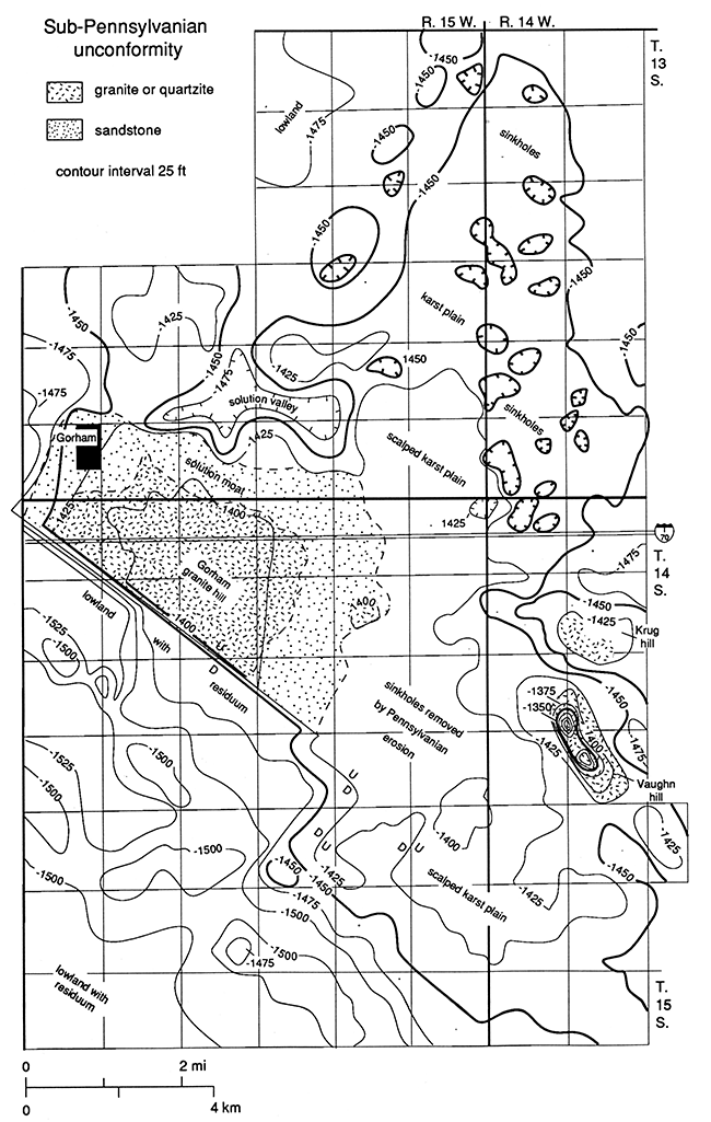
Granite hill
Weathering in Late Mississippian and Early Pennsylvanian time had little effect on the Gorham granite hill other than altering part of the feldspars and ferromagnesium minerals, resulting in a thin regolith of "granite wash." Rain water running off this hill area entered the porous basal sandstone and dissolved the 10-20% carbonate cement. This process enhanced reservoir porosity in the sandstone while forming a solution valley surrounding the Gorham hill. The solution valley or moat was best developed on the east side of the Gorham hill coinciding with the updip edge of the Reagan Sandstone, forming what was to become the most prolific portion of the unconformity reservoir of the Gorham oil field.
Quartzite hills
Rain falling on the Vaughn and Krug quartzite hills in Late Mississippian and Early Pennsylvanian time had little effect on the resistant quartzite. On a much reduced scale, a small topographic solution-moat was developed around each of these hills by concentrated dissolution of the sandy dolomite member onlapping those hills, leaving a residual sand with a silicified crust.
Arbuckle karst plain
Elsewhere over the broad area of outcropping flat-lying Cambro-Ordovician Arbuckle beds, rain water partially dissolved the dolomite rocks in an irregular manner forming sinkholes and leaving a regional mantle of residual clay, chert, and sand. This residuum (called "conglomerate" by operators) is preserved in a few sinkholes as shown on cross sections A-B and B-C (figs. 5 and 6, wells 2, 4, and 34). Residuum is preserved in the low areas south of the oil field shown at mile posts 1 through 3 on the cross section. Residuum also is shown by wells 29, 30, and 53. The resulting weathered lowlands were then a karst plain of low topographic relief covered by a residual mantle of oxidized shale, oolitic chert, and/ or sand.
Time of formation of the karst plain
The time of formation of the karst plain in the Gorham oil field and throughout the extensive Central Kansas uplift can be dated as preDesmoinesian, Pennsylvanian, or earlier. Rocks of the Kansas City Group rest directly on Precambrian crystalline rocks over the summits of the Precambrian quartzite hills. Those areas of resistant quartzite were erosional remnants on Precambrian surface. They were hills in Cambrian and Ordovician time and were islands during the deposition of the Cambrian basal sandstone and the deposition of the Cambrian dolomites. They were not buried until Middle Ordovician time when the sandy dolomite member overlapped the hills and was deposited over them. The history of similar quartzite hills approximately 25 mi (40 km) southeast in Barton County was summarized at length in an earlier publication (Walters, 1946).
In the remainder of the greater Gorham oil field area, the Arbuckle beds on which karst topography was developed were buried under Pennsylvanian, Desmoinesian, and Marmaton Group limestones and shales. This is true even for the summit area of the Gorham granite hill which was not a topographic feature during the deposition of the Cambrian Reagan Sandstone and Cambrian portion of the Arbuckle dolomite. That area was not a topographic high until post-Arbuckle, pre-Pennsylvanian faulting raised the area relative to the remainder of the Gorham area. The time of formation of the karst plain can only be bracketed as post-Arbuckle (Ordovician) and pre- or Early Pennsylvanian (Desmoinesian).
During Desmoinesian time, eastern Kansas was intermittently a coal swamp of low relief. The abundant vegetation, now formed into coal, provides evidence of a warm humid climate. The flat plain area of central Kansas, barely above sea level in Desmoinesian time, was subject to much erosion by the dissolving power of fresh rain water. The existing karst topography was further developed with collapsed caverns, sinkholes, and disappearing surface streams going into "swallow holes" and becoming subsurface drainage. The time available for development of karst topography includes the Early Pennsylvanian, all of the Mississippian, the Devonian, the Silurian, and part of the Ordovician, totaling over 100 m.y.
Evidence from eastern Kansas indicates that solution erosion, cavern formation, and sinkhole collapse began shortly after the deposition of the Arbuckle carbonates in pre-Simpson (Middle Ordovician) time. Merriam and Adkinson (1956) described Simpson-filled sinkholes in eastern Kansas. Gore (1954) mapped sandstones of Simpson age in paleo-caverns within the Cotter dolomite in the Spavinaw Lake area of northeastern Oklahoma. Kerans (1988) described extensive karst-controlled reservoir heterogeneity in the Ellenburger Group carbonates of west Texas. He presents evidence from oil-field cores and well logs that the Arbuckle-equivalent carbonates had extensive pre- or subSimpson development of widespread brecciated (broken) rocks representing collapsed caverns partially filled with Simpson-age sands and clays. These cavern systems were large-sized features, laterally extensive, intermittently for hundred of miles, and vertically for 300 ft (90 m) to even as much as 900 ft (270 m). The breccias are now buried under several hundred feet of Simpson-Viola (Ordovician) and Silurian rocks, providing clear evidence that regionally extensive paleokarst formation occurred in pre-Simpson (Middle Ordovician) time. A similar situation prevails in eastern Tennessee where the Arbuckle-equivalent carbonates are the host rock for commercial zinc and lead deposits of the Mississippi Valley type in brecciated paleokarst as described by Ohle (1985) and by others cited in his writing. In central Kansas the sub- or pre-Simpson unconformity is not obvious locally but is apparent only on a regional scale such as diagrammed in fig. 8. It is concluded that the now-buried paleokarst surface at the top of the Arbuckle in the Gorham oil field commonly considered as Early Pennsylvanian in age had its initial development in Middle Ordovician time.
Scalped karst plain
The Gorham anticline in Early Pennsylvanian time was a positive area formed by intermittent upward vertical movement relative to surrounding lower areas. The faulting of the southwest flank of the Gorham oil field anticline in post-Arbuckle-prePennsylvanian time provides evidence for such differential movement. While the Pennsylvanian seas were transgressing across the shoal area of the future Gorham oil field, much of the weathered, leached residual mantle was removed by wave erosion. As a result, the future oil-producing area of the Gorham oil field became a scalped karst plain. On it, Pennsylvanian marine limestones (incorporating a few sand grains and chert pebbles) were deposited directly on fresh dolomite. Relatively few sinkholes were preserved as the regional regolith was eroded and removed. Only a few Arbuckle test holes in the present Gorham oil field are dry holes because of encountering residuum-filled sinkholes instead of fresh, porous dolomite. This situation is in sharp contrast to the situation in the Kraft-Prusa oil field about 25 mi (40 km) southeast in Barton County (Walters and Price, 1948), where one-fourth of all oil test holes drilled were dry holes because they encountered sinkholes in the Arbuckle regardless of whether the test wells were drilled on 10-acre, 20- acre, or 40-acre (4-, 8-, or 16-hectare) spacing.
For the buried paleokarst topographic surface mapped in fig. 10, it is not feasible to indicate individual sinkholes or even interconnected sinkholes forming valley sinks, because of the scale of the map. Detailed criteria for distinguishing among marine conglomerate, locally transported conglomerate or land wash, and residuum weathered in situ were described in an earlier publication (Waiters, 1946, p. 690-699).
Common oil reservoir
Please refer again to fig. 10 (p. 21), which illustrates the low-relief topography of the sub-Pennsylvanian unconformity surface even after being modified slightly by later uplift, tilting, and arching. Note that the entire oil-producing area of the Gorham oil field is defined by the -1,450-ft contour. There is less than 50 ft (15 m) of relief except over the two areas of the Precambrian buried hills. This contour, 1,450 ft (435 m) below sea level, parallels the original oil-water contact near subsea -1,440 ft (-432 m), which unites the vast sub-Pennsylvanian common oil reservoir of the Reagan Sandstone and the Arbuckle Group dolomites in the greater Gorham oil field. It marks the spill point for oil migrating long distances through the subsurface porosity developed beneath this ancient land surface. The oil, which migrated into, through, and beyond the Gorham anticline, moved in mid-Permian time in response to regional loading and tilting (Walters, 1958 and 1987), until differentially entrapped in the Arbuckle dolomite reservoirs of central Kansas, including the Gorham anticline which was filled to the spill point. This unified, extensive sub-Pennsylvanian unconformity oil reservoir, with its originally uniform oil-water contact, justifies the term "Gorham oil field" for an oil-producing area of 50 mi2 (130 km2),
Long-distance migration of Arbuckle oil
John L. Rich (1931) first discerned that Ordovician oil in Kansas had migrated a long distance (several hundred miles) from Oklahoma to the Kansas oil fields. Gussow (1954) established the principle of differential entrapment of oil and gas during such migration. Walters (1958) applied Gussow's principles to central Kansas oil fields, demonstrating long-distance migration by the evidence of differential entrapment in central Kansas oil reservoirs. Recent investigations by Burrus and Hatch (1987, 1989) of crude-oil geochemistry provide additional confirmation for the long-distance migration of Ordovician crude oil from the Anadarko basin of southern Oklahoma into the central Kansas "shelf" area, including the Gorham oil field. They state that "Oils from the Kansas shelf are similar to the Anadarko oil types except that they have only traces of toluene and no detectable benzene. These compounds are removed by water washing and, hence, could have been lost by contact with formation water during long-distance migration. The lack of mature source rocks in southern and central Kansas and the loss of benzene and toluene is consistent with oil migration from the central Anadarko basin. . ." in southern Oklahoma. Note that Ordovician (Arbuckle and Simpson) crude oil, but not Pennsylvanian (Lansing-Kansas City) crude oil, is described as migrating from Oklahoma into Kansas.
Trapping and accumulation of Arbuckle oil
The Arbuckle dolomite and Reagan Sandstone common oil reservoir is the principal oil reservoir in the Gorham oil field. Although these formations were deposited in Cambrian and Ordovician time and their porosity enhanced by subareal karstforming solution erosion in Early Pennsylvanian and earlier time, oil could not have accumulated until after the truncated trap was sealed by the deposition of mid-Pennsylvanian sealing beds, shale, and limestone. Evidence from elsewhere in central Kansas (Waiters, 1958) established that the principal time of migration and accumulation of oil in the Cambrian-Ordovician oil reservoirs of central Kansas was mid-Permian. Thus, rocks forming the principal reservoir of the Gorham oil field of Cambrian age (Reagan Sandstone) and of Ordovician age (Arbuckle dolomite) were eroded in Pennsylvanian and earlier time with enhancement of porosity, were sealed in mid-Pennsylvanian Missourian time, and were filled in mid-Permian time with oil which migrated from what is now Oklahoma. The reservoir was tilted and the oil shifted in Cretaceous, Tertiary, and Quaternary time, yet the accumulation of about 100 million barrels of recoverable oil was confined until drilled in 1926.
Prev Page--Introduction || Next Page--Geology--Lansing-Kansas City, Permian
Kansas Geological Survey, Geology
Placed on web Jan. 30, 2015; originally published 1991.
Comments to webadmin@kgs.ku.edu
The URL for this page is http://www.kgs.ku.edu/Publications/Bulletins/228/03_geol.html