![]()
Prev Page--Abstract || Next Page--Stratigraphy
Introduction
Purpose and Scope of Investigation
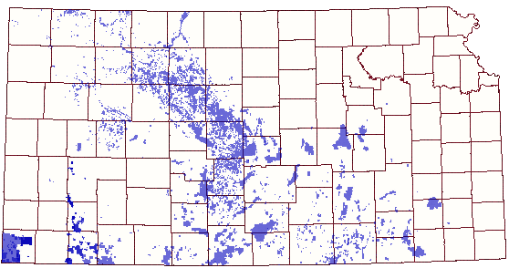
The Upper Pennsylvanian, Missourian, Lansing-Kansas City Groups are of interest to oil explorationists in Kansas, as they are very prolific oil-producing sections of rock, particularly in southern and west central Kansas. Areas of present and past oil and gas production are shown in Figure 1. Recent exploration drilling has focused attention on northwestern Kansas as an area of additional discoveries. Studies of outcrops in eastern Kansas have provided much data on sequences of rock types in these cyclic deposits, but the detailed rock facies relationships in the producing areas of western Kansas are still not clear.
Figure 1--Map illustrating areas of past and present oil and gas production from the Lansing-Kansas City Groups in Kansas. [Updated from older figure--created by new KGS interactive map system that shows producing zones.]
The objective of this study is to describe the stratigraphy and sedimentation of the Lansing-Kansas, City section in a portion of northwestern Kansas and southwestern Nebraska, emphasizing the distribution and predictability of hydrocarbon reservoirs occurring in the carbonate rocks of this interval. To this end, data used here are those available to explorationists working in the area, specifically well logs, drilling samples, and well cores; and the methods, then, should be applicable in company offices and in the field. Cores and cuttings reveal the characteristic cyclicity of rock units. These data assist in choosing the critical parameters of the well logs to be used in mapping. This complementary approach facilitates extrapolation of rock observations to areas between points of sample control.
A regional lithofacies framework is interpreted in terms of the depositional facies of the original sediment. Well-log data and sample descriptions" are integrated for interpretation of these facies and are illustrated through the use of geologic cross sections, maps of log-parameters, isopach maps, and lithofacies maps. It is hoped that this report will augment present oil and gas investigations in the study area and provide a model for exploration in other prospective areas of western Kansas.
area of Investigation
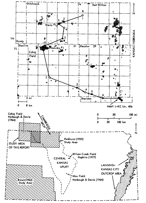
The study area, illustrated in Figure 2, includes parts of northwestern Kansas and southwestern Nebraska. Rawlins County, Kansas, was chosen for detailed evaluation of information from logs, cores, and well cuttings. Cores and related data from wells in Red Willow and Hitchcock counties, Nebraska, and Sheridan and Decatur counties, Kansas, were also examined.
Figure 2--Study area in northwestern Kansas and Southwestern Nebraska. Black area are oil fields. Cahoj Field, in north-central Rawlins County, is labeled. Three cored wells, Core Wertz #1, Skellyt Bartovsky #1, and Conoco Adell L-KC Un. 406, are included along cross section index lines, B-B' and C-C'. Lined division within counties define townships.
Map of Kansas shows relation of study area to Central Kansas Uplift and to Cambridge Arch. (Jewett and Merriam, 1959). The Lansing-Kansas City outcrop belt is identified in eastern Kansas (Kansas Geological Survey, 1964). The study area of Brown (1963), Hopkins (1977), and Parkhurst (1959) and two wells from the study of Harbaugh and Davie (1964) (Bartovsky #1 and Denker #3) are also indicated.
Previous Studies
R. C. Moore made extensive studies of the Pennsylvanian and Permian formations in Kansas both in surface exposures and in the subsurface. He was among the early workers to apply the recognition of cyclical repetitions in this rock sequence in the Midcontinent to understanding their origin and to their stratigraphic classification (Moore, 1929, 1949, 1964). His early work has been the starting point for much of the later work that has been done regarding the timing, extent, and causes of transgression and regression of ancient seas over the continental interior during Pennsylvanian time.
Morgan (1952) established a correlation and informal letter-classification for the Lansing-Kansas City Groups in west-central Kansas using gamma ray neutron logs. These designations have been widely accepted and are used in this study with a minimum of modification.
Wilson (1957) was the first to describe carbonate buildups in the outcrop sequences of the Lansing Group. Harbaugh (1959, 1962) recognized the significance of calcareous phylloid algae in the construction of these buildups.
A correlation network of well logs from the outcrop in eastern Kansas to the subsurface of northwestern Kansas by Parkhurst (1959) allowed him to apply formation names to the subsurface Lansing-Kansas City formations. The correlations and cyclic facies established by the writer in this report indicate differences from Parkhurst's designation of the base of the Stanton Limestone and the top of the Iola Limestone. Several additional carbonate units are also recognized in the southern portion of the study area. The genetic relationship of these new units and the formations cropping out in eastern Kansas is uncertain at present and is the subject of continuing study.
Parkhurst did note that the Lansing-Kansas City Groups become thinner over the Central Kansas Uplift and thicker in the Hugoton Embayment. In examining the oil production from fields over the Cambridge Arch (Fig. 2), he found no relationship between the local thickness of a carbonate formation and its porosity.
Brown (1963) described the Middle and Upper Pennsylvanian carbonate banks in southwestern Kansas. The bank-forming carbonates were described as parts of "shoaling-upward cycles." Facies formed in shallow, high-energy environments capped the cycles. A correlation between carbonate formation thickness and lithology exists in certain zones in Brown's study area, but pre-existing structure appears not to have influenced carbonate facies distribution. Primary intergranular porosity was found to be essential to formation of oil reservoirs.
Harbaugh and Davie (1964) compared two well cores from the Lansing-Kansas City Groups, one in Stafford County on the Central Kansas Uplift and the other in Rawlins County immediately off the flank of the Cambridge Arch. Similarities are recognized in depositional environments and diagenesis of the rocks in these two areas; and, importantly, rocks in these cores have more secondary porosity than was noted in the rocks studied in Brown (1963).
Payton (1966) interpreted regional patterns of facies in the outcropping Swope and Dennis Limestones in Missouri and Iowa. He remarks on the similarity of the types, temporal sequence, and geographic position of facies within the Bethany Falls Limestone and the overlying Winterset Limestone. Change in the depth of water during deposition was concluded to be the factor that most controlled the patterns of facies and facies migration that Payton describes.
Heckel and Cocke (1969) summarized the character and distribution of the Upper Pennsylvanian, Midcontinent, algal-mound complexes in the outcrop belt. Heckel (1975) and Heckel and Baesemann (1975) added details on the stratigraphy and depositional framework of these rock units in southeastern Kansas. Mossler (1973) extended the description of facies in the Swope Limestone into southeastern Kansas and, using data of Payton (1966) and Heckel ( 1968 ), suggested an analogy between these shelf facies and those forming today in the Bahamas.
Frost (1975) described the Winterset Limestone south of the area examined by Payton. Frost recognized an algal-bank complex in southeast Kansas, which is laterally equivalent to shallow-water facies farther north. Banks appear to have developed on local bathymetric highs. Dolomitizing waters apparently flowed downward and laterally through grainstones to dolomitize the underlying mudbank deposits.
General Geology in the Vicinity of the Study Area
Structure-The study area is on the southwest flank of the southeast-northwest trending Cambridge Arch (Fig. 2). This structural feature is a large antiform feature separated from the Central Kansas Uplift to the southeast by only a slight structural depression. Major periods of movement on these structures occurred during pre-Mississippian and Middle Pennsylvanian times. Movement of the Cambridge Arch also occurred during Mesozoic time. In places, Precambrian rocks are directly overlain by beds of Pennsylvanian age (Merriam, 1963).
The Cambridge Arch is flanked by several smaller, parallel anticlinal and synclinal structures. Adell Field, in Sheridan County, where a core described in this study is located, lies along one of these anticlines.
South of the study area is the Hugoton Embayment, a broad, southward-dipping, shelf-like extension of the Anadarko Basin, which occupies the western one-third of Kansas. An isopach map of the interval from the top of the Mississippian to the top of the Lansing in Kansas (Merriam, 1963, p. 214) exhibits a number of southwest-northeast trending areas of thick and thin sections that are particularly evident in the area of the present study. In general, the Pennsylvanian sediments thicken basinward, to the southwest. Minor local structural movements, contemporaneous with deposition, are inferred here to have affected depositional conditions during Missourian time.
The mature, well-developed areas of production of oil and gas from Lansing-Kansas City rocks are located principally on the Central Kansas Uplift (Fig. 1). Production from flanking areas such as Rawlins County are still in the early to middle stages of development. Although the basin area may never be as prolific as that on the Uplift, a fair comparison cannot be made until further exploration is conducted. Graham County, for example, is located on the Central Kansas Uplift and has produced over 136 million barrels of oil from nearly 1400 wells.
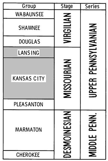
Regional Stratigraphy-The Lansing-Kansas City Groups are part of the Missourian Stage of the Upper Pennsylvanian Series (Fig. 3). The Lansing-Kansas City Groups in Kansas are composed of interbedded carbonates and shales with occasional minor coals and sandstones. In the outcrop belt in eastern Kansas (Fig. 2), the carbonate units display a variety of depositional environments ranging from phylloid algal-bearing, lime-mud banks to oolite shoals (Heckel, 1975; and Mossler, 1973). In northwestern Kansas and southwestern Nebraska, carbonate facies in the Lansing-Kansas City are also highly variable. Interbedded terrigenous clastics range from redbrown, very silty shales to black claystone.
Figure 3--Stratigraphic position of rocks of the Upper Pennsylvanian Series in Kansas (Zeller, 1968).
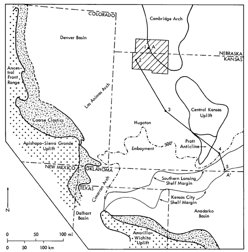
Rascoe (1962) describes the Lansing-Kansas City limestones as thickening, merging, and becoming massive southward toward the Anadarko Basin (Fig. 4). Southward of the carbonate shelf, the Missourian sequence becomes a basin facies consisting of dark gray shales, sands, and dense, thin limestones. The Anadarko Basin was subsiding and expanding northward from Morrowan through Missourian time, after which subsidence decreased, resulting in shoreline regression and basin filling during Virgilian and later time. Rascoe (1962) states, "The Missourian time marked the apex of the marine transgression over the western Midcontinent during Pennsylvanian time."
Figure 4--Missourian (Late Pennsylvanian) paleographic map of western Kansas and adjacent areas. Positive structural elements in southern and western map area: Amarillo-Wichita Uplift to south, Apishapa-Sierra Grange Uplift to the southwest, and Ancestral Front Range in the west. Cross section index line, A-A', ties study area, along upper landward shelf, with basinward shelf-edge location at A'. Southern shelf hinge-line, defining northern of Anadarko Basin, is based on position of abrupt decrease of carbinate thickness to the south. Data for map from Rascoe (1962), Maher (1953), and Martin (1965). The 500 foot Missourian interval isopach is after Rascoe (1962). The hatchured are represents the study area. Numbers on line A-A' represent well locations.
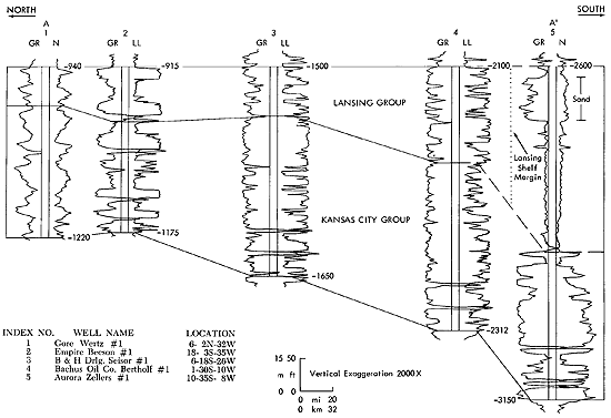
The study area is approximately 200 miles north of the Missourian shelf margin, near the northern limit of deposition of marine sediments at that time. Subsidence was less along this upper shelf than in the basin, as is evident from the northward thinning of the section (Fig. 5). Variations in the rate of subsidence and minor vertical fluctuations across the shelf could have affected the distribution of facies of Missourian sediments. Small changes in sea level could also have had important effects on shoreline positions during Lansing-Kansas City time.
Figure 5--North-south stratigraphic well-log cross section (A-A') of subsurface Missourian formations across western Kansas (see figure 4 for location). Shelf-basin transition illustrated for Lansing Group. Section datum is top of Lansing Group. Correlation lines from upper to lower are top of Lansing Group, top of Kansas City Group, and base of Kansas City Group. Subsea elevations of the top of Lansing and base of Kansas City groups are included in the figure. A larger version of this figure is available.
Prev Page--Abstract || Next Page--Stratigraphy
Kansas Geological Survey, Cyclic Sedimentation
Comments to webadmin@kgs.ku.edu
Web version Oct. 2004. Original publication date Oct. 1980.
URL=http://www.kgs.ku.edu/Publications/Bulletins/220/03_intro.html