Kansas Geological Survey, Bulletin 194, part 2, originally published in 1969
Originally published in 1959 as Kansas Geological Survey Bulletin 194, part 2. This is, in general, the original text as published. The information has not been updated.
Cross-bedding directions in limestones of the Kansas City Group have a bimodal distribution on both a local and regional scale. In each unit the primary mode to the southwest, whereas the secondary mode is in the opposite direction. The strike of megaripples In these deposits is normal to these trends. Cross bedding in associated sandstones, in contrast, is unimodal, with the average direction trending to the southwest in Kansas, west and northwest near the Oklahoma-Kansas state line, and northward in south-central Oklahoma. These data indicate that marine paleocurrent systems during deposition of limestones of the Kansas City Group moved back and forth perpendicular to the shore and were probably the result of ebb and flow of tides.
Directions of cross bedding have been studied extensively in many sandstones throughout the geologic column, but few attempts have been made to measure and interpret their significance in limestones. This is due, at least in part, to the fact that paleogeographic significance of marine cross bedding is poorly understood. Klein (1967) concluded from his analysis of modern sediment dispersal patterns that marine environments are characterized by diverse directions of current flow that may be independent of source and slope. Selley (1968) considered six models of shoreline current systems in which net sediment transport was onshore, offshore, and longshore. In his models, half the shoreline currents were bimodal. Theoretically, marine cross bedding could be produced by any current system operating at the depositional interface. Cross bedding in limestones, therefore, could be the product of longshore currents, tidal currents, density currents, etc., some of which are not obviously related to paleogeography.
A unique opportunity to study directions of cross bedding in selected limestones and to relate them to paleogeography is afforded by Pennsylvanian sediments of the Midcontinent Region. Within this stratigraphic sequence, cross-bedded oölitic and skeletal limestones occur in a number of units and are closely related in time and space to cross-bedded nonmarine sandstones. Both rock types apparently were deposited under essentially the same physiographic and tectonic setting with no major reorientation of structural elements, paleoslope, or change of source area during deposition.
The purpose of this study was to compare the depositional fabric of cross-bedded marine limestones of the Kansas City Group with that of associated nonmarine sandstones in an attempt to determine the degree of preferred orientation of marine paleocurrents during Kansas City time and the relationship of these currents to inferred paleogeography.
The writer wishes to express his appreciation to P. H. Heckel, J. M. Cocke, and D. F. Merriam for critical discussions of the problem, and to D. E. Miller for assistance in the field. P. C. Franks provided the computer program for vector analysis of cross-bedding data. Special thanks are extended to W. L. Chesser for his work in preparing the figures and to G. de Vries Klein and P. E. Potter for reading the manuscript and offering helpful suggestions.
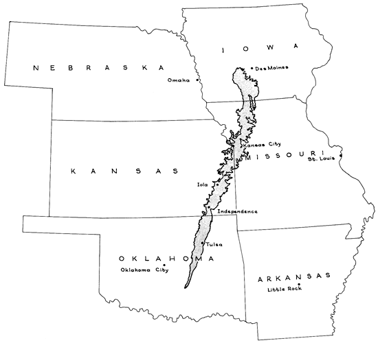
The Kansas City Group is exposed throughout eastern Kansas in an outcrop belt approximately 20 miles wide extending from Kansas City to Independence (Fig. 1). Near Iola, Kansas, the aggregate thickness of these rocks is 350 feet, but northward in Missouri and Iowa, the group thins to approximately 100 feet. Southward in Oklahoma, rocks equivalent to the Kansas City Group are mostly clastic deposits and are not differentiated lithologically or topographically from the overlying or underlying units.
Figure 1--Index map showing outcrop belt of Kansas City Group in Midcontinent Region.
In Kansas, the Kansas City Group consists of six limestone formations interbedded with six formations of shale of variable thickness (Fig. 2). Sandstone is a minor lithology in northern Kansas, but increases in volume southward and is quantitatively as great as limestone near the Oklahoma-Kansas border. Thin, discontinuous layers of coal occur in the middle part of the Kansas City Group.
Figure 2--Upper Pennsylvanian rocks in eastern Kansas investigated in this report. Nomenclature of limestones and sandstones shown on right. Cyclothem type indicated by B, C, and D, and megacyclothems indicated by Q, P, O, and N.
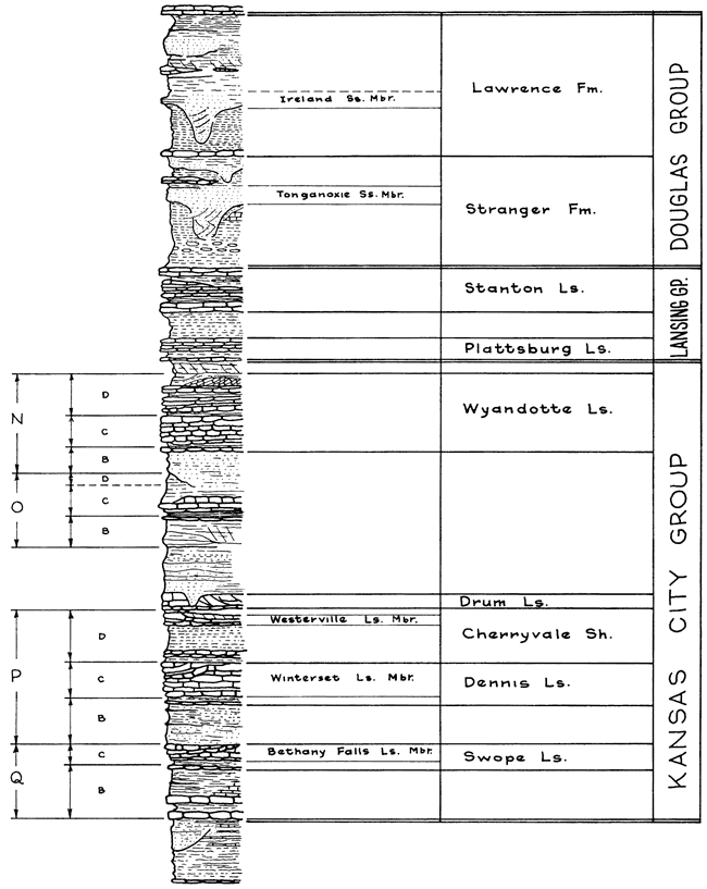
Cyclic patterns in the sequence of rocks of the Kansas City Group have been analyzed by Moore (1936, p. 29). Cyclothems are represented by sequences of sandstone, shale, and limestone, with coal and underclay locally. Three types of cyclothems have been recognized by Moore (1935, p. 29), and are designated B, C, and D at the left of the lithologic column in Figure 2. Megacyclothems are recognized by the sequence of cyclothems B-C-D and are designated Q, P, O, and N in Figure 2. Cross-bedded limestones in this rock sequence include the Bethany Falls Limestone Member of the Swope Limestone (the limestone in cyclothem C of megacyclothem Q), the Winterset Limestone Member of the Dennis Limestone (the limestone in cyclothem C of megacyclothem P), the Westerville Limestone Member of the Cherryvale Shale (limestone in cyclothem D of megacyclothem P), the Drum Limestone (not placed in a megacyclothem), and the Wyandotte Limestone (mostly in the limestone in cyclothem D of megacyclothem N). Cross-bedded limestones in the Kansas City Group, therefore, seem to be restricted to the C and D cyclothems and the Drum Limestone, which separates megacyclothems P and O.
Cross bedding is restricted to oölite and skeletal calcarenite, which typically occur in the upper part of the limestone units. The lower parts of the units are characteristically massive or thick bedded, more fine grained, and commonly somewhat siliceous. Locally the limestones thicken into marine banks and show significant lateral variation in lithologic types. Cross-bedded deposits are typically best developed at or near the top of the banks and are, therefore, restricted in areal extent to a distance of 20 to 30 miles.
The following is a brief description of the limestone units investigated. For a more complete treatment of the stratigraphy of the Kansas City Group the reader is referred to Moore (1949, p. 74-111).
The Bethany Falls Limestone Member contains some of the best expressed cross bedding in the Kansas City Group. The lower part, which ranges up to 20 feet in thickness, is a light-gray, dense, thin-bedded limestone that occurs in uneven, somewhat wavy layers separated by shale partings. Cross bedding is restricted to oö1ite in the upper part of the unit in Linn, Bourbon, and Neosho counties. In places weathering has removed the oöids leaving only interstitial material, and stratification typically is etched in bold relief.
The Winterset Limestone Member contains one of the more spectacular marine-bank developments, consisting of phylloid algal limestone and cross-bedded oölitic limestone. It is light gray and irregularly thick- to thin-bedded and is generally thicker than the older Bethany Falls Limestone Member. The Winterset is cross bedded only in the oölitic phase near the top of the unit.
The Westerville Limestone Member occurs only in northeastern Kansas and Missouri. Its lithologic character is more variable than adjacent limestone units. Commonly the lower part is dense, light gray, siliceous, moderately thin, and somewhat unevenly bedded. The upper part is cross-bedded, fossiliferous oölite commonly referred to as the "Kansas City oölite."
Major outcrops of the Drum Limestone are in the vicinity of Independence, Kansas, where locally the formation is 60 feet thick. Here, the rock is composed mostly of oölite and coarse skeletal debris, and in places it consists of limestone conglomerate. As cross-bedded oölite is predominant throughout most outcrops, the Drum undoubtedly exhibits the most spectacular cross bedding in Kansas.
The Wyandotte Limestone is best developed in Johnson and Wyandotte counties in northeastern Kansas, where it attains a maximum thickness of about 60 feet. Thin, wavy bedding dominates most of the formation, and fossils are abundant. The Wyandotte consists of three limestone members separated by shale, but cross bedding is prominent only in the oölitic Farley Limestone Member at the top of the formation.
Cross bedding is not a prominent feature in limestones of the overlying Lansing Group (Fig. 2), but some directional data was obtained for use in preparing a generalized map summarizing directions of paleocurrents.
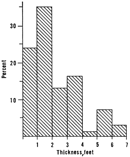
Cross bedding in limestones of the Kansas City Group occurs only in units composed of oöids, pellets, and skeletal debris. It is generally expressed by variation in grain size, degree of cementation, and, more rarely, by color changes. In many outcrops weathering has etched strata in bold relief so that size, shape, and orientation of the layers within the sets are distinct. In vertical section, cross bedding appears to be both planar and tabular with only minor festoons or troughs (Fig. 3; Fig. 4). Although good exposures showing sets of cross-strata in three dimensions are rare, several outcrops in quarries, road cuts and river beds expose large segments of horizontal section through sets of strata, so that a reasonably accurate three-dimensional geometry of the structure can be obtained. In horizontal section, cross-strata form a broad arc concave down-current. Although few complete sets of cross-strata are fully exposed, some are more than 30 feet wide and range from 10 to 50 feet in length. One of the best exposures of a horizontal section through sets of cross-strata is in a creek bed in Allen County, Kansas (Fig. 5). No set is completely exposed, but, judging from the size of the configuration of the arc marking the boundaries between the sets, it is highly probable that many sets could be as much as 100 feet wide. Additional good exposures of horizontal sections through the strata are found on the surface above the cement quarry near Independence (NW sec. 4, T. 33 S., R. 16 E., Montgomery County, Kansas). Data obtained from these exposures indicate that much of the cross bedding in Kansas City limestone units occurs in sets ranging up to 100 feet in width, 30 feet or more in length, and 1 to 7 feet in thickness. Figure 6 shows a histogram of the frequency distribution of thickness of sets of cross-strata in the formations studied. Sets of cross-strata range from less than 3 inches to slightly more than 6 feet in thickness. Most are approximately 1-foot thick. Strata within sets are concave slightly in a down-current direction. Contacts between sets invariably are erosional.
Figure 3--Cross bedding in limestones of Kansas City and Lansing groups in Montgomery County, Kansas. A, Stanton Limestone in Tyro Quarry, SW SE sec. 30, T. 34 S., R. 15 E. B, Drum Limestone in Independence Cement Plant Quarry, sec. 5, T. 33 S., R. 16 E.
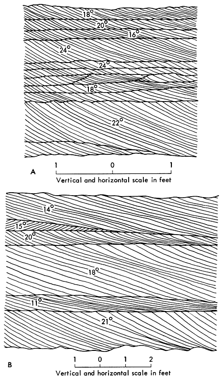
Figure 4--Cross bedding in limestones of Kansas City and Lansing groups. 2 Exposure in small quarry in SW sec. 33, T. 25 S., R. 21 E., Allen County, Kansas, in Winterset Limestone Member of Dennis Limestone. Cross-strata typical of most units of Kansas City Group. Note lower sets dip left, whereas upper sets dip in opposite direction. B, Exposure of Stanton Limestone in Tyro Quarry SW SE sec. 30, T. 34 S., R. 15 E., Montgomery County, Kansas, showing constant dip direction for all sets. Most sets relatively thin, but where boundary between sets is obscure, cross-strata appear large-scale. This stratification type restricted to Stanton and Drum limestones in southern Kansas.
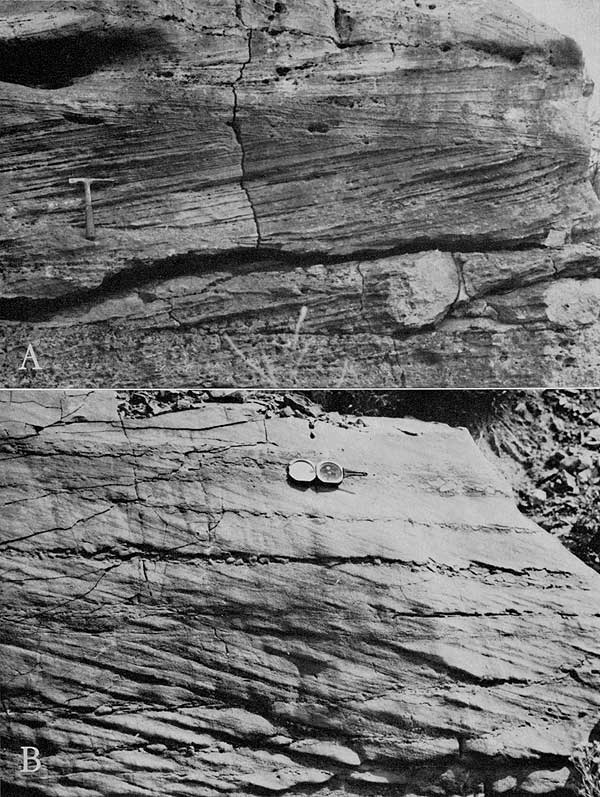
Figure 5--Map of cross-bedding sets in top of Bethany Falls Limestone Member in creek bed, SW SW SW sec. 25, T. 26 S., R. 20 E., southern Allen County, Kansas. Heavy lines mark boundaries between sets; lighter lines show strata within sets; blank areas covered. Rose shows azimuths of dips.
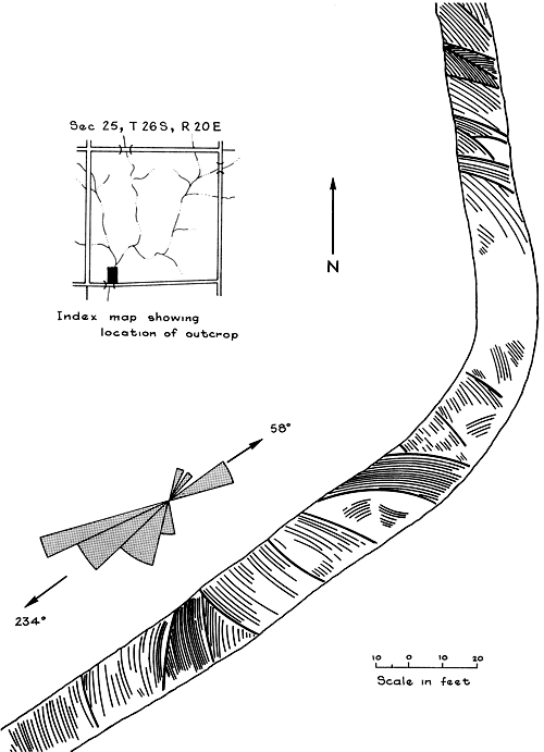
Figure 6--Histogram showing frequency distribution of thickness of sets of cross-strata in limestones of Kansas City Group.
In the Bethany Falls, Winterset, and Wyandotte limestones, cross bedding is restricted to calcarenitic facies, generally in the upper part of the unit, which apparently grades laterally into massive or wavy-bedded facies. Size of the cross strata commonly increases upward, so that the largest sets are near the top. Cross-bedded facies within these units are not distributed evenly throughout the outcrop but are concentrated in local areas where the formations are thickest and rarely extend more than 30 miles along the outcrop belt. In the Bethany Falls and Winterset limestones, cross bedding is best developed in the central part of the outcrop belt in Linn, Bourbon, and Allen counties. In the Wyandotte and Westerville limestones it is best developed to the north in Johnson County and adjacent areas.
Near Independence, Kansas, the Drum is abnormally thick and is cross bedded throughout the entire exposure. Most sets of strata range between 2 and 5 feet in thickness and are generally thicker than those in other limestones of the Kansas City Group. Geometry of the strata is similar to that in the Bethany Falls, but dips commonly are steeper. The Drum in this area consists primarily of approximately equal proportions of oölitic and skeletal calcarenite. Cross strata commonly are expressed by alternating layers of skeletal debris (or coquina) and an oölite. Layers range from 0.5 to 8 inches in thickness, but most are approximately 2 inches thick. The coquina contains many fragments over 0.5 inch in diameter and is much coarser than the oölite. A notable textural feature is the vertical gradation from coarse coquina to coarse oölite to fine oölite within a single stratum. Fossil debris typically is oriented along planes of stratification, producing a definite fabric in the rock. Thus, there is generally a greater textural difference between strata within sets than between sets. This unique feature, together with the remarkably constant direction of dip in cross beds of the Drum, produces the illusion that the cross-strata are extremely large-scale, as the boundary between sets is obscure and the dipping strata from one set appear to connect with those above and below. Local variations are common in the Drum, such as that seen in an outcrop along the Verdigris River 3.5 miles north of Independence, Kansas, where the formation is composed primarily of Myalina shells 2 to 3 inches long, crudely stratified in large-scale cross beds.
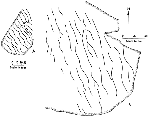
Megaripple marks in the Winterset and Iola limestones are found in large exposures on the floors of several quarries in the central part of the outcrop belt, and constitute the only significant paleocurrent structure other than cross bedding. Ripple crests are symmetrical arcs having amplitudes of 1 to 2 feet. Wave lengths of ripples range from 13 to 15 feet, giving ripple indices between 9 and 15. The regional trend of the ripple marks is relatively constant at each locality, although crests locally are slightly curved and form a sinuous or anastamosing pattern (Fig. 7). In places, crests of the ripples bifurcate or merge with adjacent ripples. Many crests, however, can be traced more than 200 feet across a quarry floor.
Figure 7--Sketches showing form and trend of megaripples in the Winterset Limestone Member exposed on quarry floors in Miami County, Kansas. Quarry A is located in SW NE sec. 12, T. 18 S., R. 23 E., quarry B in NW NW SE Sec. 27, T. 18 S., R. 23 E.
Exposures on a quarry wall in the Iola Limestone (Fig. 8, 9) show that the internal structure of the ripple is not cross bedded, but consists of layers of limestone ranging from 3 inches to more than 1 foot in thickness. Limestone layers generally thin or pinch out over the crests of the ripples and thicken markedly near the troughs. The megaripples have a relatively long wave length compared to the amplitude, and are characterized by flat, shallow troughs separating the crests. Most of the amplitude of the ripple is restricted to within 3 or 4 feet of the crest, so that the troughs are essentially flat.
Figure 8--Cross-section showing internal structure of megaripples exposed on quarry wall in Iola Limestone, SE sec. 18, T. 17 S., R. 23 E., Miami County, Kansas.
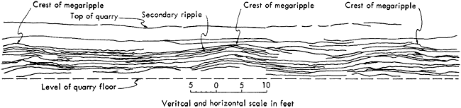
Figure 9--Megaripple marks in limestones of Kansas City Group. A, Exposure showing expression of megaripple in both horizontal (quarry floor) and vertical section. Quarry in Iola Limestone in SE sec. 18, T. 17 S. R. 23 E., Miami County, Kansas. B, View showing internal structure of megaripple; same area shown in right of Figure 8. Arrows point to reference marks 1 foot apart. Note thickening of limestone units over crest of ripple and distribution of small secondary ripples along many bedding planes.
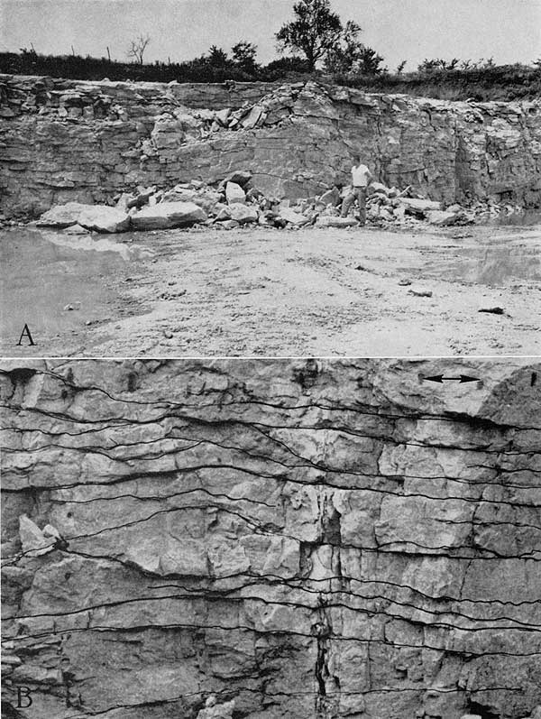
The internal structure of the ripple consists of layers of seemingly homogeneous, massive limestone ranging in thickness from 3 inches to more than 1 foot. Shale partings separate limestone units and form a secondary ripple surface, with wave lengths ranging from 4 inches to 1 foot, and amplitudes of approximately 1 inch. This secondary rippling has caused the wavy bedding typical of much of the lower Winterset limestone beds. Beds overlying the megaripples maintain a constant thickness, and appear to be unaffected by the surface or internal structure of the megaripples below.
Bedding exposed in quarry walls in the megarippled units is relatively distinct and is expressed by thin shale partings. If traced laterally, however, the shale partings pinch out, so that the massive or homogeneous limestone layers appear to merge and bifurcate.
Trends of megaripples are constant within a given area (Fig. 7), and represent one paleocurrent system. Little or no variation in trends of megaripples was observed vertically in exposures.
A total of 351 measurements of cross-stratification were made at 66 stations in road cuts, ravines, creek banks, and streams, and quarries in limestones of the Kansas City Group. Because exposures are limited, no rigid sampling plan was possible, but attempts were made to obtain measurements throughout the entire outcrop belt. An average of six measurements per outcrop was obtained.
In analyzing directional data, measurements first were plotted on a circular histogram to determine general distribution. A pronounced bimodal distribution was apparent at almost every station sampled, with modes nearly 180° apart. For this reason, measurements grouped about each mode were treated separately for additional statistical analysis.
Directional data were analyzed by computer for vector restultants at each locality, plus a measure of central tendency, referred to as the "consistency ratio" by Reiche (1938). All measurements from each formation were grouped, and the vector mean or consistency ratio was determined for grouping around each mode. A summary of all marine cross bedding in limestones of the Kansas City Group was determined subsequently by the same method. Megaripples in the Winterset Limestone Member were measured and plotted on the cross-bedding map.
In addition to the regional study of the Bethany Falls, Winterset, Westerville, Drum, Wyandotte, and Plattsburg and Stanton limestones, a detailed study of the Drum Limestone in the cement quarry at Independence, Kansas, was made, in which 168 measurements were obtained in the quarry face and from horizontal exposures on the shelf above the quarry.
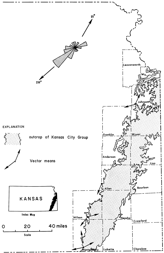
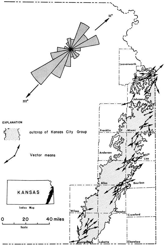
A summary of regional patterns of directions of cross bedding in the Bethany Falls, Winterset, Westerville, Drum, Wyandotte, and Plattsburg and Stanton limestones is shown in Figures 10 to 15. Arrows represent vector resultants for all measurements at a given locality; a circular histogram shows the frequency distribution and modes for all measurements from each unit. Several striking characteristics of directions of cross bedding are evident. In each unit a bimodal distribution is present with principal modes ranging between 219° and 238° and secondary modes between 25° and 62.° The primary and secondary modes are, therefore, nearly 180° degrees apart. The framework of primary sedimentary structures in each limestone is essentially the same, even though the formations are distributed throughout a thickness of 350 feet and represent possibly 12 cycles of sedimentation. In general, cross bedding is symmetrically distributed about the mode, although in the Winterset and Westerville limestones there appears to be considerable scatter. The strongest central tendency seemingly is in the Bethany Falls and Drum limestones where the greatest number of measurements was obtained.
Figure 10--Directions of cross bedding in the Bethany Falls Limestone Member.
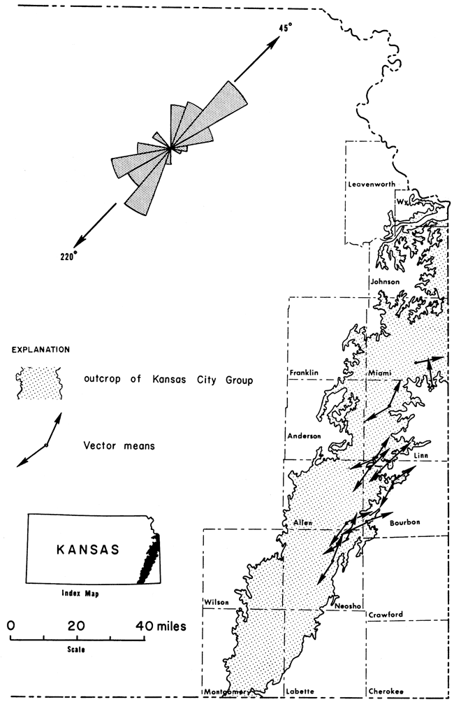
Figure 11--Directions of cross bedding in the Winterset Limestone Member.
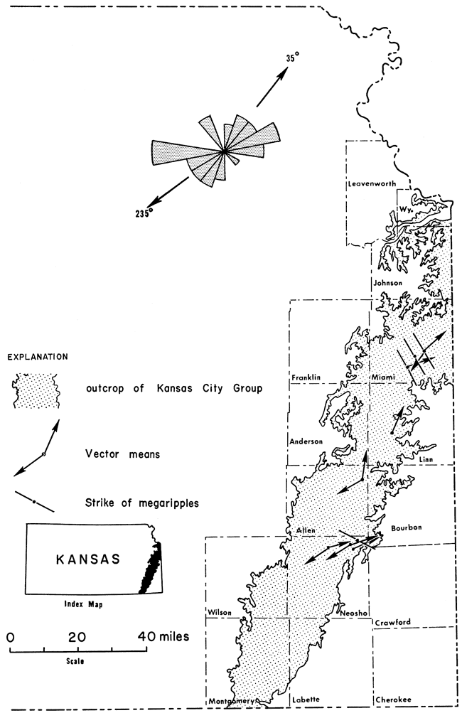
Figure 12--Directions of cross bedding in the Westerville Limestone Member.
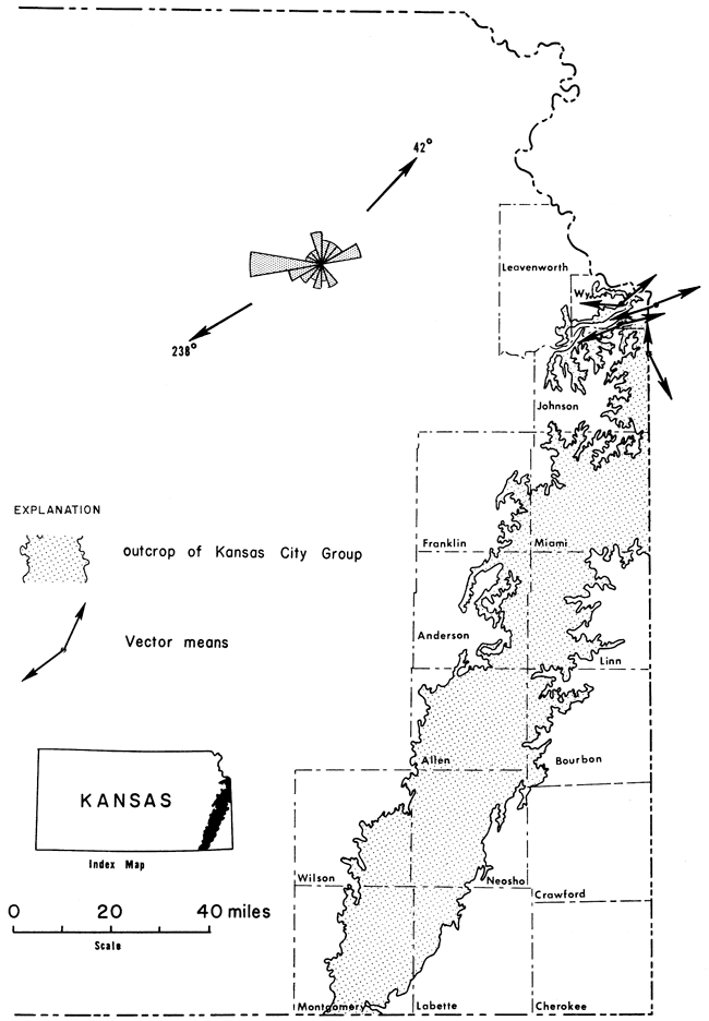
Figure 13--Directions of cross bedding in the Drum Limestone.
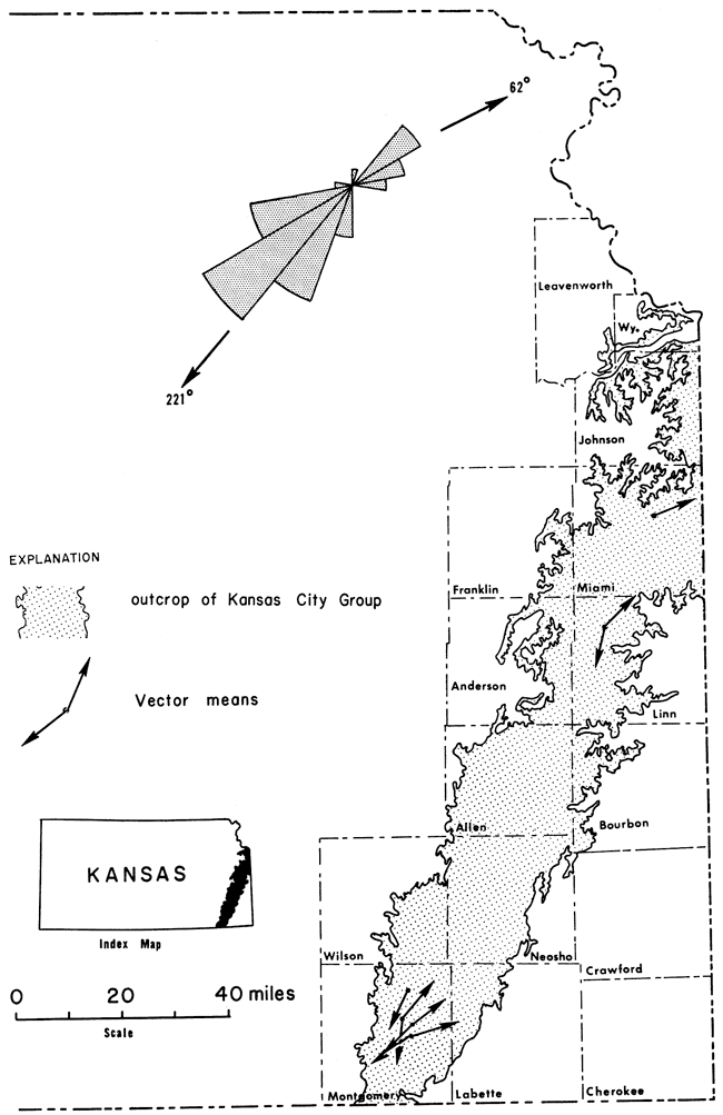
Figure 14--Directions of cross bedding in the Wyandotte Limestone.
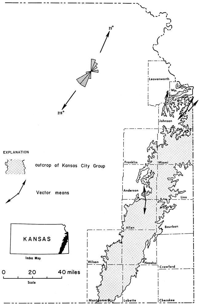
Figure 15--Directions of cross bedding in the Plattsburg and Stanton limestones.
Bimodal distribution of directions of cross bedding is not only well expressed in the regional summaries but also is readily apparent in outcrops. This is especially true where plan view of the structure is exposed in some stream beds and quarries. An excellent example is an exposure in a creek bed in southern Allen County (Fig. 5). Of the 22 sets exposed, seven dip within a 60° arc to the northeast and 16 within a 90° arc to the southwest. The primary mode is S 54° W and the secondary mode is N 58° E. There are slightly more than twice as many sets dipping to the southwest as to the northeast. There is, therefore, a strong preferred orientation and remarkable symmetry in the current structures at this outcrop with no directions to the northwest or southeast.
Although only a few outcrops have horizontal sections through sets of cross strata, enough were found to substantiate the pattern of directions of cross bedding shown in Figure 4. Moreover, at a given locality, the bimodal distribution is clear from the cross bedding direction measured at random throughout the exposure.
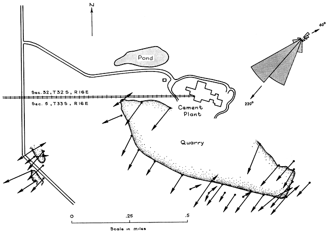
The major exception to the definite bimodal distribution is in the Drum Limestone in the vicinity of Independence, Kansas. In a large cement-plant quarry, a strong unidirectional orientation with only minor reversals was observed (Fig. 16). The strong preferred dip to the southwest is obvious at nearly every locality. This produces an illusion that the cross bedding is extremely large-scale inasmuch as the textural variation between sets of strata is commonly less than that between the individual layers. Elsewhere in the Drum, however, bimodal distribution is present so that the summary frequency diagram for the entire formation is similar to the other limestone units studied.
Figure 16--Map showing directions of cross bedding in the Drum Limestone exposed in cement plant quarries sec. 5, T. 33 S., R. 16 E., near Independence, Kansas. One hundred sixty-eight measurements were taken at 32 wall localities selected at random. Length of arrows proportional to number of measurements. Note strong primary mode to southwest expressed in summary rose diagram.
Megaripples in the Winterset limestone also have a strong preferred orientation in which the crests of the ripples are roughly perpendicular to the two modes of cross-bedding directions. In three localities where numerous megaripples are exposed on the floors of quarries, strike of the crests is N 30° W (Fig. 7, 11).
If measurements of directions of cross bedding in all limestones studied are considered, the bimodal distribution is stronger and the symmetry about the mode is greater (Fig. 17). The depositional framework of each limestone formation is essentially the same, consisting of a primary direction to the southwest and a secondary direction 180° out of phase to the northeast.
Figure 17--Summary map showing cross-bedding directions in all limestones studied. Note bimodal distribution and symmetry of rose diagram.
Cross bedding in sandstone units associated with these deposits is unimodal in contrast to the bimodal distribution of cross bedding in the marine limestones of the Kansas City Group, with the direction of sediment transport to the southwest throughout most of Kansas and to the north and northwest throughout Oklahoma. Figure 18 is a compilation of data obtained from the Douglas Group of Kansas (Bower, 1961), the Vamoosa Formation in Oklahoma (Hicks, 1962) and the Englevale Sandstone Member (Marmaton Group) of Kansas (Howard, 1959), together with the cross-bedding measurements obtained by me from sandstone and siltstone units of the Kansas City Group.
Figure 18--Cross-bedding directions in sandstones associated with limestones studied. Rose diagram summarizes directions in Vamoosa Formation of Oklahoma, and Douglas, Kansas City, and Marmaton groups in Kansas.
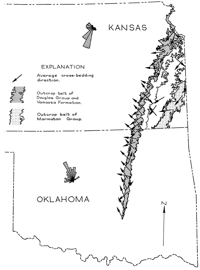
Throughout most of Kansas, cross bedding in sandstones associated with the Kansas City Group trend to the southwest although significant northwest directions occur in southern Kansas. In Oklahoma, Hicks (1962) found that cross-bedding directions in the Vamoosa Formation (equivalent to the Douglas Group and part of the Shawnee Group in Kansas) show significant variations in the dominant southwest directions. Near the Oklahoma-Kansas border west and northwest directions similar to those in the Douglas Group were mapped. Southward, however, the northwest trend becomes stronger and in the southernmost exposures cross-bedding directions are almost due north. In all sandstones considered there is relatively little scatter about the mean at any locality and the central tendency for all measured is high as shown by the frequency distribution diagrams in Figure 18.
Major aspects of depositional environment of the cross-bedded skeletal and oölitic limestones of the Kansas City Group can be interpreted with considerable confidence. Under the tectonic setting in which Pennsylvanian sediments of the Midcontinent were deposited, rocks of this nature could not represent an environment other than shallow marine in which skeletal and oölitic debris was washed back and forth on a shoal. The scale of the cross bedding, together with associated micrite deposits and occasional pebble-sized fossil fragments, indicates that the transporting currents were marine and not eolian.
In contrast, sandstones of the Kansas City, Douglas, and Marmaton groups typically are fine grained and occur in channels in shale units. Thickness ranges from 0 to 100 feet. Large-scale cross bedding dominates in thicker parts of the sandstone bodies, whereas small-scale or micro-crosslamination is characteristic near margins. Sandstone channels trend southward (Sanders, 1959; Howard, 1959). Plant fragments are common, and Bower (1961) reports several specimens of Calamites in a vertical position. Some marine fossils, however, have been found locally within these sandstones (Ball, 1964). These data, together with observations from other Pennsylvanian sandstones in the Midcontinent Region (Potter and Pryor, 1961), indicate that the sandstones are dominantly fluvial, although parts of some units may be associated with a deltaic complex and could be considered marginal marine.
Cross-bedding directions in the sandstones of the Douglas, Kansas City, and Marmaton groups indicate that the paleoslope in Kansas was to the southwest, both before, during, and after deposition of the Kansas City Group. This trend seemingly existed throughout most of the Midcontinent Region (Potter and Pryor, 1961). In Oklahoma there is strong evidence of highlands in the Arbuckle region as indicated by northward paleocurrent directions in the Vamoosa Formation (Fig. 18). Throughout most of Kansas, however, a strong southwestern paleoslope existed, for it is only in northern Oklahoma that significant north-directed current structures have been measured in the Pennsylvanian sandstones.
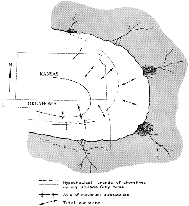
Sediment dispersal was from the northeast in Kansas, from the east and southeast near the Oklahoma-Kansas state line, and from the south in central Oklahoma. These data indicate that the shoreline during Kansas City time probably formed an arc similar to those indicated in Figure 19. Transgression and regression would cause the shoreline to shift, but the basic pattern of paleoslope and regional trends of shorelines would remain constant. Thickness of sediment and convergence of fluvial cross-bedding directions indicate that the axis of maximum subsidence was in central Oklahoma.
Figure 19--Paleogeographic map showing regional slope, hypothetical trend of shorelines, and tidal current systems in the Midcontinent Region during Kansas City time.
Marine paleocurrents in the Kansas City Group, though variable and bimodal, have a definite preferred orientation which is related to the paleoslope. The primary current system moved down the regional slope parallel to dispersal patterns in fluvial sandstones, whereas the secondary current system flowed in exactly the opposite direction. Sand waves of oölitic and skeletal debris in limestones of the Kansas City Group moved back and forth perpendicular to regional trends of ancient shorelines. This pattern, which persisted throughout deposition of all cross bedded limestones of the Kansas City Group, suggests that oscillating tidal currents caused much of the sand wave migration and the bimodal distribution of cross bedding.
Klein (1965) arrived at a similar conclusion in a study of the Great Oölite Series of southern England, as did the members of a Sedimentation Seminar (Univ. Indiana, 1966) in a study of the cross bedding in the Salem Limestone of Indiana. Selley (1967) also arrived at this same conclusion in a study of the rocks in the Sirte Basin of Libya. Bimodal distribution of cross bedding reported from the above-mentioned studies is remarkably similar to that found in limestones of the Kansas City Group both locally and regionally. All have a primary mode down the regional slope with a secondary mode in the opposite direction. Distribution of cross bedding is essentially symmetrical about the mode.
Although little has been published concerning sedimentation in an offshore tidal current environment, there are several pertinent papers which suggest that tidal currents may be a major factor in the dispersal of oölites and skeletal limestones. Off (1963) in a study of bathymetric charts of coastlines of the world characterized by large vertical tides concluded that tidal-shaped sand deposits can be separated into two groups: (1) ridges oriented parallel to the current, and (2) sand waves oriented perpendicular to the current. Jordan (1962) found a similar situation on Georges Banks off the New England coast where sand waves are oriented both parallel and perpendicular to the sea-floor contours. One of the best documentations relating modern tidal currents and directional sedimentary properties is the study made by Reineck (1963) who found that tidal sand waves in the North Sea are composed of numerous sets of cross-strata which oscillate through 180° following the ebb and flood tides. Within these sand bodies most cross bedding dips seaward because the ebb tide is stronger.
Regional slope during Kansas City time, as determined from cross bedding in fluvial sands, was to the southwest throughout most of Kansas and to the north and northwest in Oklahoma. The trends of the ancient shorelines during this time formed a large arc with depositional strike northwest-southeast throughout most of Kansas (Fig. 19).
Cross bedding in limestones of the Kansas City Group is characteristically bimodal with the primary mode off-shore and down the regional slope. The secondary mode is in the opposite direction, indicating a current system moving toward the shore. The most logical explanation for paleomarine currents in limestones of the Kansas City Group is that they are tidal. Orientation, size, and internal structures of modern tidal sand bodies provides a model of sedimentation for the interpretation of modern paleocurrent systems of limestones in the Kansas City Group where cross bedding is prominent.
Ball, S. M., 1964, Stratigraphy of the Douglas Group (Pennsylvanian, Virgillan) in the northern Mid-Continent Region: Unpub. Ph.D. dissertation, Dept. Geol., Univ. Kansas, v. 1, p. 1-335; v. 2, append., p. 337-490.
Bower, R. R., 1961, Dispersal centers of sandstones in the Douglas Group (Pennsylvanian) of Kansas: Unpub. Master's dissertation, Dept. Geol., Univ. Kansas, 19 p.
Howard, L. W., 1959, Englevale Sandstone (Pennsylvanian) of eastern Bourbon and northeastern Crawford counties, Kansas: Unpub. Master's dissertation, Dept. Geol., Univ. Kansas, 96 p.
Hicks, R. V., 1962, Paleocurrent directions in the Vamoosa Formation (Pennsylvanian) of Oklahoma: Unpub. Master's dissertation, Dept. Geol., Univ. Kansas, 28 p.
Jordan, G. F., 1962, Large submarine sand waves: Science, v. 136, p. 839-848.
Klein, G. de Vries, 1965, Dynamic significance of primary structures in the Middle Jurassic Great Oölite Series southern England; in, Primary sedimentary structures and their hydrodynamic interpretations, Middleton, G. V., Ed.,: Soc. Econ. Paleont. & Mineral., Spec. Pub. 12, p. 173-191
Klein, G. de Vries, 1967, Paleocurrent analysis in relation to modern marine sediment dispersal patterns: Am. Assoc. Petroleum Geologists, Bull., v. 51, no. 31 p. 366-382.
Moore, R. C., 1935 [1936], Stratigraphic classification of the Pennsylvanian rocks of Kansas: Kansas Geol. Survey, Bull. 22, 256 p. [available online]
Moore, R. C., 1949, Divisions of the Pennsylvanian System in Kansas: Kansas Geol. Survey, Bull. 83, 203 p. [available online]
Off, Theodore, 1963, Rhythmic linear sand bodies caused by tidal currents: Am. Assoc. Petroleum Geologists, Bull., v. 47, no. 2, p. 324-341.
Potter, P. E., and Pryor, W. A., 1961, Dispersal centers of Paleozoic and later clastics of the upper Mississippi Valley and adjacent areas: Geol. Soc. America, Bull., v. 72, no. 8, p. 1195-1249.
Reiche, Parry, 1938, An analysis of cross-lamination: the Coconino sandstone: Jour. Geol., v. 46, no. 7, p. 905-932.
Reineck, Hans-Erik, 1963, Sedimentgefüge in Bereich der südlichen Nordsee: Senckenberg. Naturforsch. Gesell., Abh. 505, 137 p.
Sanders, D. T., 1959, Sandstones of the Douglas and Pedee Groups in northeastern Kansas: Kansas Geol. Survey, Bull. 134, pt. 3, p. 125-159. [available online]
Indiana University, 1966, Cross-bedding in the Salem Limestone of central Indiana: Sedimentation Seminar, Bloomington, Indiana: Sedimentology, v. 6, no. 2, p. 95-114.
Selley, R. C., 1967, Paleocurrents and sediment transport in nearshore sediments of the Sirte Basin, Libya: Jour. Geol., v. 75, no. 2, p. 215-223.
Selley, R. C., 1968, A classification of paleocurrent models: Jour. Geol., v. 76, no. 1, p. 99-110.
Kansas Geological Survey, Paleocurrent Directions in Limestones of the Kansas City Group, Eastern Kansas
Placed on web Jan. 21, 2009; originally published in May 1969.
Comments to webadmin@kgs.ku.edu
The URL for this page is http://www.kgs.ku.edu/Publications/Bulletins/194_2/index.html