![]()
Prev Page--Introduction || Next Page--Depositional Environment
Stratigraphy
Upper Part of the Dakota Formation
Sandstone beds in the upper part of the Dakota consist mainly of light olive-gray, fine-grained silty sandstone that is composed largely of subangular to subrounded quartz grains. Some of the sandstones are argillaceous, and a few contain thin to very thin layers of silty to finely sandy shale. Nearly all of the sandstones contain carbonized plant fragments. Most of the sandstone beds are poorly cemented and friable, but where extensively weathered they are generally cemented firmly by limonite. High limonite content has colored these weathered rocks dark yellowish-orange, light-brown (5YR 5/6), other shades of brown, and several shades of red and reddish-brown. Although some of the sandstone occurs as thin or very thin beds, most of the units are medium to very thick bedded. Most units are evenly bedded, but some are irregular owing to the presence of clay-ironstone concretions. At some localities sandstone beds are gently cross laminated but ripple marks are very sparse in beds that I have examined.
Shale in the upper part of the Dakota is medium to medium dark-gray, ranges from sandy to only slightly silty, and generally contains thin lenses and laminae of silt or very fine sand. The least silty shales are indistinguishable from shale in the Graneros except for the presence of nodules or layers of clay ironstone as at Locality 3 and near the mouth of Big Creek in southwestern Russell County. Some of these shales contain large, well-formed crystals of selenite. Many shale units in the upper part of the Dakota contain an abundance of carbonaceous matter and some are lignitic.
The most common fossils in uppermost Dakota rocks are carbonized plant remains. Fish scales and bones and worm burrows and castings occur at a few localities and a single Lingula was observed at Locality 20. At several localities in Russell and Lincoln counties, sandstone beds lying as much as 20 feet below the top of the Dakota contain assemblages of marine invertebrates preserved as molds or limonitized shells. This fauna includes gastropods, mussels, clams, and oysters, mostly of species not found in the Graneros (Hattin, 1956, p. 87).
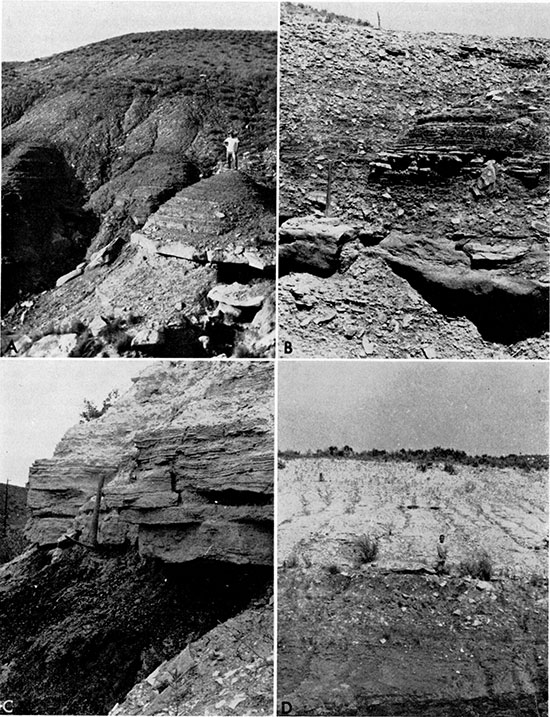
The Dakota-Graneros contact is transitional at many localities and differs greatly in aspect within short distances along the outcrop. The nonuniform position of the contact with respect to marker beds reflects the intertongued nature of the two units. In some exposures the uppermost part of the Dakota consists of thick-bedded, and locally clayey, sandstone and in other places consists of thin, evenly bedded layers of sandstone that lie above clayey to sandy, commonly carbonaceous, or, rarely, lignitic shale. Locally the uppermost Dakota beds consist largely of silty shale similar to that in the overlying Graneros; elsewhere the Graneros succeeds dominantly sandy beds in the upper part of the Dakota through several feet of interbedded sandstone, siltstone, and silty shale (Fig. 3, A, B). In general the upper part of the Dakota can be distinguished from the Graneros by the predominance of sandstone or carbonaceous shale in the former. Furthermore, where units of thick-bedded sandstone sharply underlie a typical Graneros section, as at Localities 1, 3, 10, 12, and 19, the Dakota-Graneros contact can be determined without difficulty. Where the lithology is gradational or consists of an alternating succession of sandstone and shale beds, the following criteria have been found to be useful in establishing the contact. Sandstones in the uppermost part of the Dakota contain an abundance of carbonized wood fragments and/or ferruginous matter, including clay-ironstone nodules. Molds of sideritic? spherulites are common locally in the uppermost Dakota sandstone beds. Silty shale units in this part of the section, although otherwise like shale in the Graneros, as noted above, contain layers or nodules of clay ironstone composed largely of siderite. The Dakota-Graneros contact was selected as the top of a clay-ironstone concretion zone in transitional shale sequences at Localities 7 and 37. and at the top of a thin sandstone unit containing clay-ironstone nodules or lying just above clay-ironstone-bearing shale at several localities.
Figure 3--Contacts with adjacent strata. A, Dakota-Graneros contact (man's feet) in sec. 24, T 22 S, R 22 W, Hodgeman County. Uppermost part of Dakota consists of interbedded sandstone and silty or sandy shale. Note color change at contact. B, Uppermost part of Dakota in sec. 25, T 22 S, R 22 W, Hodgeman County (Loc. 20). Note alternation of sandstone and shale beds above pick head. C, Graneros-Greenhorn contact (pick head) in sec. 35, T 12 S. R 14 W, Russell County (Loc. 1). Skeletal limestone at base of Greenhorn contrasts sharply with shale below. D. Graneros-Greenhorn contact (boy's feet) in sec. 18, T 13 S, R 12 W, Russell County. Note abrupt change of color and bed of skeletal limestone at base of Greenhorn.
The top of the Dakota is commonly marked by a highly limonitic zone according to Plummer and Romary (1942, p. 345). Such a zone marks the top of the Dakota at many exposures that I studied, especially including those at Localities 1, 2, and 20, but at many places this criterion is not applicable as, for example, at Localities 3, 13, and 19 and at several places where the two formations are gradational. The top of the Dakota is marked by a nodular bed of pyrite 0.3 to 0.4 foot thick at Locality 22.
Lower Part of the Greenhorn Limestone
Strata overlying the Graneros Shale are assigned to the Lincoln Limestone Member of the Greenhorn Limestone. At most exposures in the central Kansas outcrop the basal part of the Lincoln includes beds of hard skeletal limestone (termed inoceramite by Hattin, 1962) consisting chiefly of prisms broken from Inoceramus valves. Other common constituents are whole and fragmented shells of oysters and Inoceramus, sharks' teeth, coprolites, grains of quartz sand and silt, and bentonite pebbles. These limestone beds are commonly cross bedded, with as much as 14 degrees of dip locally, and have a petroliferous odor when freshly broken. Beds above the basal limestone unit include alternating layers of olive-gray to olive-black shaly chalk that weathers yellowish-brown, grayish-orange or dark yellowish-orange, and olive-gray chalky limestone that is usually weathered yellowish-gray, grayish-orange or dark yellowish-orange. The Graneros-Greenhorn contact is easily recognized in weathered exposures by marked upward change in color from gray to mostly pale shades of yellow and orange (Fig. 3, D).
The abruptness of contact between mostly noncalcareous shale in the upper part of the Graneros and the limestones in the overlying Lincoln Member is suggestive of a stratigraphic hiatus because the contact at most places separates rocks deposited in a low-energy environment from those of a high-energy environment of deposition (Fig. 3, C). At a few localities near the northern and southern ends of the outcrop skeletal limestone is lacking or inconspicuously developed at the base of the Lincoln. At Locality 38, in Washington County, a bentonite marker bed near the top of the Graneros is overlain by 4 feet of shale, the upper l.8 feet of which is calcareous, olive-black in color, and very much like lower Greenhorn shaly rocks elsewhere. Above these rocks lie l.8 feet of calcareous shaly beds containing a few very thin lenses of fine-grained skeletal limestone that may be equivalent to the basal Lincoln elsewhere in Kansas. The transitional character of these strata and poor development of skeletal limestone in the basal Greenhorn unit suggest that the hiatus between Graneros and Greenhorn, if indeed there is one here, is apparently of less magnitude than farther to the south. At Locality 44, Cloud County, the bentonite marker bed is overlain by l.2 feet of calcareous shale containing a few skeletal limestone lenses. The shale is overlain by a half foot of d irk yellowish-brown unfossiliferous? calcilutite that is taken as the base of the Greenhorn. The calcilutite is overlain by 5.7 feet of olive-black shaly chalk, the lower 3.0 feet of which contains numerous very thin skeletal limestone lenses with Inoceramus pictus, coprolites, and cirriped remains. The shaly chalk is overlain by 4.1 feet of alternating noncalcareous Graneros-like fissile shale and olive-black shaly chalk. The calcareous upper part of the Graneros, lack of a thick skeletal limestone unit in the basal part of the Lincoln, and recurrence in the lower Lincoln beds of Graneros-like shale suggests that the Graneros-Lincoln contact apparently does not represent as great a hiatus as it does farther to the south. From Locality 44 southward to Barton County, Greenhorn carbonates everywhere rest with abrupt stratigraphic contact and marked lithologic contrast upon noncalcareous or locally weakly calcareous and dominantly terrigenous rocks in the upper part of the Graneros, and lie 0.5 to 3.2 feet above the bentonite marker bed. Near the south end of the central Kansas outcrop, skeletal limestone lies at the base of the Lincoln only at Localities 20 arid 39. At Localities 23, 24, and 25 a bentonite bed several inches thick lies at the base of the Greenhorn. This bentonite is not correlated with the bentonite marker bed for reasons explained below. At Locality 41 a fossiliferous sandstone bed lying 3.5 feet below the top of the Graneros can be correlated with a sandstone bed lying 16.8 feet below the top of the formation at Locality 20, just 10 miles to the north. Absence of the bentonite marker bed at the southern end of the outcrop and stratigraphic evidence of erosion of the upper part of the Graneros at Locality 41 is evidence that the hiatus at the Graneros-Greenhorn contact is of greater magnitude than it is farther north.
The basal Lincoln beds generally contain abundant specimens of Inoceramus pictus Sowerby, which ranges into the overlying Hartland Shale Member of the Greenhorn, molds of a large species of Dunveganoceras, Ostrea beloiti Logan, a small species of Exogyra, and rarely, Exogyra columbella Meek, and fragments of a hamitid ammonite. At Locality 41, the lower part of the Lincoln contains specimens of Euomphaloceras aluaradoense Stephensen and Plesiacanthoceras wyomingense (Reagan).Graneros Shale
Name and Definition
The Graneros Shale was named by Gilbert (1896, p. 564) for 200 to 210 feet of argillaceous or clayey shale lying between the top of the Dakota and the base of the overlying Greenhorn Limestone. The type locality is Graneros Creek, a southwestern tributary of Greenhorn Creek, approximately 20 miles north of Walsenburg, Colorado. According to Bass, et al. (1947), Gilbert included in the upper part of the Graneros some calcareous strata more appropriately assignable to the Lincoln a-id Hartland Members of the Greenhorn. Thus, in the Model Anticline southwest of La Junta, Colorado, the Graneros is 153 feet thick by original definition but only 105 feet thick if the upper calcareous beds are included in the Greenhorn (Bass, et al., 1947). The revised, and more logical, definition was accepted by McLaughlin (1954, p. 111) for Baca County, Colorado, but not by Baldwin and Muehlberger (1959, p. 59) or Wood, et al. (1953) for northeastern New Mexico. The difficulty arises because the lower Greenhorn is less limy west and southwest of Kansas, and in southeastern Colorado and northeastern New Mexico it contains only a few widely separated thin limestone beds. In Kansas, the Graneros comprises mostly noncalcareous strata that lie between the Dakota Formation, below, and the limestone and impure shaly chalk of the Lincoln Limestone Member of the Greenhorn, above. Because of transitional beds between the Dakota and Graneros the contact between the two is commonly difficult to ascertain, but the wellcemented skeletal limestone that nearly everywhere marks the base of the Lincoln Member is a generally reliable guide to the top of the Graneros. My definition of the Graneros in Kansas corresponds to the usage of Bass, et al. (1947) and McLaughlin (1954).
Northward from Kansas, the term "Graneros" is applied generally to beds lying between the Dakota and Greenhorn formations but what has been commonly called "Dakota" in the Black Hills and Williston Basin areas is actually the top of the Lower Cretaceous Inyan Kara Group (Gries, 1954). In the Black Hills, Darton (1904, p. 391) included in the Graneros beds that are now called (ascending) Skull Creek Shale, Newcastle Sandstone, Mowry Shale, and Belle Fourche Shale. Some geologists still follow this practice. In the subsurface of eastern Wyoming, western South Dakota, and western North Dakota these formations are included in the Graneros Group by many geologists. However, Hansen (1955) abandoned the term Graneros in the North Dakota subsurface and Haun (1958, p. 86) did not see the necessity for retaining the name Graneros for these strata in the surface and subsurface areas of the southwestern Black Hills. Gries (1954, p. 447) has shown that the Newcastle Sandstone is probably a western tongue of the type Dakota; thus, the homotaxial equivalents of the Graneros in the Black Hills appear to be the Mowry and Belle Fourche shales. The former is siliceous, the latter clayey.
According to Waage (1955, p. 41) the Newcastle Sandstone is the lithologic equivalent of the upper sandstone of the South Platte Formation of the northern Colorado Front Range foothills, and the upper South Platte is the lithologic equivalent of the upper part of the Dakota in the Graneros type area. 'Wherever the Benton has been divided along the Front Range foothills in Colorado, the Graneros, Greenhorn, and Carlile are recognized. Thus in the area embraced by the Black Hills, the eastern South Dakota outcrop, the Kansas outcrop, the south-central Colorado outcrop, and the Front Range foothills, the Graneros might logically be defined as the body of shale that lies between the Dakota below, including major tongues thereof, and the Greenhorn above. However, the Mowry Shale, which is included in this body of shale, is lithologically unlike the Graneros of the type area and no useful purpose would be served by including the Mowry and Belle Fourche in a restricted "Graneros Group" unless it be for emphasis of homotaxial relationships. The lithologic equivalent of the Graneros in the Black Hills and surrounding areas is the Belle Fourche Shale. Considerable similarity exists between these two formations, and, if the name Graneros is to be perpetuated in the Black Hills region, it would be best used to replace the name Belle Fourche over which the fermer has priority.
History of Nomenclature
The earliest complete classification of Cretaceous strata in the Western Interior Region is that by Hall and Meek (1856, p. 405) who divided the Missouri River section of Nebraska into units numbered one through five from the base upward. Geographic names based on places of typical exposure were published subsequently by Meek and Hayden (1861, p. 419) in a comprehensive tabulation that included lithologic and paleontologic descriptions and thicknesses for each of the five units. The name "Fort Benton Group" was introduced for the beds of unit No. 2, now called, in ascending order, Graneros, Greenhorn, and Carlile. Later, Hayden (1876, p. 45) coined the term "Colorado Group" for No. 2 (Fort Benton), No. 3 (Niobrara), and No.4 (Pierre) of Hall and Meek's Nebraska section. The Colorado Group was restricted by White (1878, p. 21) to units No. 2 and No. 3 and has remained thus defined to the present. The name "Benton" has fallen into general disuse in most areas where that part of the section is divided into formations. In Kansas the term "Benton Group" had formal status at least until 1920 (Moore, p. 83). The name "Benton Shale" or "Benton Formation" is used today in parts of central and north-central Colorado, southeastern Wyoming, northwestern Iowa, and southwestern Minnesota where Graneros, Greenhorn, and Carlile subdivisions are not differentiated.
In Kansas the Benton Group remained undivided until 1896 when Cragin (p. 49, 50) proposed the name "Russell Formation" for beds equivalent to the Graneros Shale, the Greenhorn Limestone, and the Fairport Member of the Carlile Shale, and the name "Victoria clays" for strata equivalent to the upper part of the Carlile. In contrast to Cragin's classification is that of Logan (1897, p. 215) who recognized in the Benton a lower limestone group and an upper shale group. Logan's lower limestone group included the Graneros and Greenhorn formations of the modern classification. Shale in the basal 20 to 40 feet of the limestone group was called "Bituminous Shale Horizon" by Logan (1897, p. 216).
The name "Graneros Shale" was proposed by Gilbert (1896, p. 564) for the lowermost of three lithologic subdivisions of the Benton Group along the Arkansas River in eastern Colorado. Logan (1899a, p. 84) recognized that the Graneros was the stratigraphic equivalent of his Bituminous shale, but the name Graneros was not used formally' in Kansas until 1904 (Darton, pl. 36). Since that time the only addition to nomenclature of the Graneros in Kansas is the informal designation "bentonite marker bed" (Merriam, 1957a) for a thick bentonite that lies near the top of the formation in most of central Kansas.
Distribution and Thickness
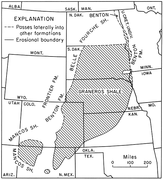
The central Kansas outcrop of the Graneros Shale extends from Washington County in the northeast to northern Ford County in the southwest (Fig. 1). In this area the Graneros ranges in thickness from a minimum of 23.6 feet at Locality 9 to a maximum of 40.4 feet in a composite section based on exposures at Localities 32 and 40, and averages 30.5 feet for 20 measured sections including three that are composite. Additionally, a few exposures are known in Hamilton and Kearny counties, near the western border of the State, where Bass (1926, p. 36) reported a composite thickness of 61 feet. Merriam (1957a) has traced the Graneros throughout the subsurface of western Kansas and gave 100 feet as the approximate maximum thickness of the formation in Kansas. Regional distribution of the Graneros Shale and nomenclature of units into which the formation passes laterally are shown in Figure 4. Unless otherwise noted, thickness figures given in the succeeding paragraphs are for rocks that are lithologically equivalent to the Graneros, insofar as such equivalence could be determined in the cited literature.
Figure 4--Map showing regional distribution of the Graneros Shale and nomenclature of laterally contiguous units.
In southeastern Colorado the Graneros thickens from 86 feet in Baca County (McLaughlin, 1954, p. 112), to 105 feet on the Model Anticline (Bass, et al., 1947), to 136 feet in the Chandler Syncline (Mann, 1958, p. 158). Clair (1955, p. 34) reported 100 to 150 feet of Graneros in the subsurface of the western flank of the Denver Basin, and Scott ( 1963) measured 2 IO feet of Graneros equivalent in the Kassler quadrangle, Colorado. Thicknesses of 200 to 220 feet are cited for exposures of the Graneros throughout the Arkansas River Valley at Colorado Springs and near Walsenburg and Trinidad, Colorado, by Dane, et al. (1937, p. 210), but from their brief lithologic descriptions it is apparent that these figures are for the Graneros as originally defined and thus include some beds that are better referred to the Greenhorn Limestone.
The Graneros Shale crops out extensively in the northeastern part of New Mexico where exposures on the east side of the Sangre de Cristo Mountains extend as far to the south as Las Vegas. The formation thickens southwestward from 86 feet in Baca County, Colorado, to 160 feet in Colfax County, New Mexico (Griggs, 1948, p. 25), and to 215 feet in a well 3.5 miles northwest of Las Vegas, New Mexico (Griggs and Hendrickson, 1951, p. 30). Near Ocate, a few miles north of Las Vegas, Bachman (1953) measured 395 feet of Graneros Shale, but he admits the possibility of error owing to the nonuniform dip of strata. In the area west of the Sangre de Cristo Mountains, Rankin (1944) traced the Graneros Shale into the San Juan Basin and as far to the southwest as Socorro, New Mexico, at a time when the Graneros, Greenhorn, and Carlile equivalents were known only as a part of the Mancos Shale. The term Graneros is now widely used in the San Juan Basin. Beds assigned to the Graneros by Rankin (1944) range in thickness from 60 feet in the northwestern part of New Mexico to a maximum of 350 feet west of Albuquerque, but these thicknesses include some strata assignable to the Greenhorn, according to Cobban (written communication,1964). In most of the sections measured by Rankin, a bentonite bed 0.5 to 0.6 inch thick lies approximately 1.5 feet below the top of the formation.
Northward from Kansas the Graneros is recognized throughout much of Nebraska and South Dakota, in the northwestern part of Iowa, and in western Minnesota. On the east bank of the Big Sioux River in Plymouth County, Iowa, I have measured a section in which the Graneros is 34.7 feet thick. According to Condra and Reed (1959, p. 18) the Graneros is 60 to 70 feet thick in northeastern Nebraska [My own observations lead me to conclude that this figure is nearly double the minimum thickness in this area.]; 40 to 90 feet thick in the Republican River Valley of southcentral Nebraska, and thickens to 550 to 700 feet or more in northwestern Nebraska and 900 feet in exposures around the Black Hills. In the latter two areas the thicknesses are for the combined Mowry and Belle Fourche shales but, as noted above, only the Belle Fourche is lithologically equivalent to the Graneros. In the northern part of the Julesburg Basin in Nebraska, where local facies changes complicate the stratigraphy, a shale unit that is the approximate equivalent of the Belle Fourche is about 300 feet thick as shown by McCrae (1956), and in the eastern and southeastern parts of the Powder River Basin the Belle Fourche Shale ranges in thickness from 270 to 480 feet (Haun, 1958, p. 86). At the type locality in Crook County, Wyoming, the Belle Fourche is 560 feet thick (Collier, 1923, p. 83). Fuenning (1942) noted that the Graneros Shale is missing locally over the Chadron Arch in northwestern Nebraska. Contacts picked by Fuenning apparently do not coincide with those by geologists of the State Geological Survey of Kansas because he reported 299 feet of Graneros in a well in Decatur County, Kansas, in an area where, according to Merriam (1957a, p. 13), the formation has a nearly uniform thickness of 40 feet.
In South Dakota the Graneros thickens generally from east to west. In the southeastern part of the State the formation ranges in thickness from 30 to 200 feet (Barkley, 1952, p. 13) and in the northeastern part from 200 to 300 feet (Erickson, 1954). In western South Dakota, the term "Graneros" is commonly used in the sense of Darton (1904) but, as noted above, only the Belle Fourche Shale may be regarded as the lithologic equivalent of the Graneros in Kansas. The Belle Fourche is 401 feet thick near Rapid City (Condra and Reed, 1959, p. 20), is 490 feet thick locally in the southwestern most part of South Dakota (Baker, 1948, p. 72), and is as much as 510 feet thick in Harding County in the northwesternmost part of South Dakota (Baker, 1952, p. 18).
In North Dakota, where the term "Belle Fourche" is used for the lithologic equivalent of the Graneros of Kansas, Hansen (1955) recorded a thickness ranging from 100 feet in the eastern part of the State to 450 feet on the west side. In the Williston Basin, along the eastern edge of Montana, the Belle Fourche ranges from 80 to 370 feet in thickness (Billings Geol. Soc., 1961).
Silty Shale
[The term "shale" is used throughout this report for fissile, clayey, sedimentary rocks.]
The predominant lithology of the Graneros is noncalcareous shale that ranges from very slightly silty to finely sandy. Most commonly the shale is moderately silty. In a fresh cut in the overflow spillway at Wilson Dam (Loc. 43) the upper 15.6 feet of Graneros shale are only slightly calcareous and partially preserved shell material is abundant in two shale zones. At Locality 15, in a continuously and actively eroding exposure, the upper 5.5 feet of the Graneros are also slightly calcareous. At four other localities (Loc. 1, 6, 26, 44) the upper 0.15 to 1.2 feet of shale is slightly calcareous or even somewhat chalky. Where dug from trenches fresh shale breaks into irregular and rather tough blocks that usually split easily along obscure laminae. During initial stages of weathering the shale breaks into innumerable small flakes that characterize almost every Graneros exposure. At some localities, notably 7, 17, and 18, shale in the upper part of the formation weathers into large papery sheets. The shale is soft and plastic when thoroughly wet, but it is brittle when dry. Fresh shale is most commonly of medium dark-gray color. Less than half as common are dark-gray and medium-gray colors, and only about one-fourth as common are shales of olive-gray (5Y4/1, 5Y3/1) color. At a few exposures other shades of gray, olive-gray, and black were noted. The dominant colors of partially weathered shale flakes are, in order of importance, medium lightgray, olive-gray, medium-gray, light olive-gray (5Y6/1), medium olive-gray, and medium brownish-gray. Highly weathered shale is generally pale, moderate, or dark yellowish-brown, dusky yellow, or dark yellowish-orange with none of these colors predominating. In some exposures, partially weathered shale units are mottled, owing to oxidation of organic constituents.
Most shale units in the Graneros contain numerous layers or lenses of coarse terrigenous silt or fine and very fine sand (Fig. 5, A, B). These bodies range in thickness from thin laminae to thin beds that are commonly thinly laminated. The thinnest lenses and laminae are generally the most fine-grained and serve to enhance the fissile bedding of the shale. Although shale near the top of the Graneros is locally as sandy as shale near the base, the higher shales contain fewer laminae, lenses, and beds of fine sandstone than do those in the lower part of the section (Fig. 5, C).
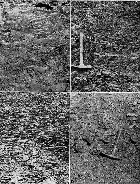
Figure 5--Features of silty shale in the Graneros Shale. A, Silty shale containing numerous lenses and laminae of quartz silt; lower part of formation in sec. 13, T 12 S, R 15 W, Russell County (Loc. 13). B, Lenses of silty sandstone in silty shale in lower part of formation in sec. 29, T 15 S, R 10 W, Ellsworth County (Loc. 18). C, Silty shale in upper part of formation in sec. 29, T 15 S, R 10 W, Ellsworth County (Loc. 18). Note flaky weathering and lack of sandstone or siltstone beds. D, Large mass of selenite in lower part of formation in sec. 25, T 22 S, R 22 W. Hodgeman County (Loc. 20).
Nearly all units of gray shale contain carbonaceous matter that ranges in size from specks less than a millimeter in width to chunks large enough to be identified as carbonized wood, the former being the most common. A majority of shale units contain gypsum either in finely granular, almost powdery form, or as isolated euhedra or platy aggregates of sparry selenite (Fig. 5, D). The gypsum lies along joints and bedding planes, the latter being most usual. Some euhedral crystals are several inches in length and aggregates of crystals are commonly a foot across, but small selenite crystals, a millimeter or two in length, or rosettes of small crystals, are most common. These minute crystals, where lying parallel to the bedding, also serve to enhance bedding fissility. At many exposures weathered slopes of the Graneros are aglitter with sunlight reflected from selenite crystals.
At six localities in the lower few feet of the formation, the shale contains pyrite as small oblate spheroidal nodules nowhere more than an inch in diameter or as minute crystals disseminated throughout the rock. At Locality 28 the basal shale unit is marcasitic. In the lower part of the formation and sparsely in the upper part, melanterite was detected by taste in many shale units. This mineral has probably resulted from the oxidation of marcasite or pyrite and is too fine to be detected with a lens. Seven samples of fresh shale from the lower part of the Graneros, and one sample of weakly calcareous shale from the upper part, were selected for partial chemical analysis in order to determine the relative abundance of pyrite, gypsum, and organic carbon in these rocks. The results, in percentage of the total sample, are tabulated below. The two samples poorest in organic carbon are also poorest in amount of pyrite and gypsum, suggesting a genetic relationship among these three substances. Graneros shale is usually stained along joints and bedding by a yellow-colored substance rich in iron that has been identified as jarosite by X-ray methods. Here and there this mineral also occurs in very thin layers lying parallel to general stratification. Less abundant volumetrically, but nearly as widespread, is limonite, which likewise stains both bedding and joint surfaces. These two minerals are further evidence of the iron sulfide content of the rock before oxidation.
Table 1--Partial chemical analyses of shale samples from the Graneros Shale.
| Locality | Unit | Pyrite* | Gypsum* | Organic carbon |
|---|---|---|---|---|
| KG-1† | H | 0.007 | 0.15 | 0.50 |
| KG-1 | K | 0.77 | 0.97 | 4.66 |
| KG-1 | L | 0.82 | 3.54 | 2.22 |
| KG-23 | F | 0.11 | 0.40 | 1.74 |
| KG-23 | M | 0.36 | 1.34 | 1.34 |
| KG-24 | B | 0.026 | 0.04 | 0.45 |
| KG-30 | F | 1.72 | 6.01 | 1.22 |
| KG-43‡ | J | 7.65 | 1.0 | 6.85 |
| * Calculation based on assumption of no organic sulphur. † Numbers are localities given in Appendix. ‡ Calcareous shale from upper part of formation. |
||||
Oblate spheroidal nodules of pure crystalline alunite lie in shale near the top of the Graneros at Locality 8 and rest just below a thick bed of bentonite that is characteristic of the upper part of the formation. The alunite is nearly white, cryptocrystalline, and brittle. Similar nodules were observed in a shale unit that lies about 15 feet below the top of the Graneros at Locality 32, and also on a weathered shale slope at the top of the section that is exposed at Locality 30.
Shale samples from four key sections were analyzed for major clay mineral constituents. [Some of the clay reported as montmorillonite may be thoroughly degraded three-layered clay minerals (John B. Droste, oral communication, November, 1964).] The results of these analyses are summarized stratigraphically in Table 2. The illite content remains nearly uniform throughout the section, including samples from the Dakota. Through the same stratigraphic interval, kaolinite decreases upward as montmorillonite increases. Despite the clayey nature of the Graneros shale, quartz is the dominant mineral in 17 of 24 units for which the clay-nonclay ratio was determined. Clay and quartz are of approximately equal abundance in two additional samples. Much of the quartz is apparently of the finer silt and perhaps even clay sizes, which cannot be differentiated in the field.
Table 2--Diagrammatic tabulation of kaolinite-illite-montmorillonite (K:I:M) in shale units in four key sections, expressed as parts in ten of total clay content. (Not to scale.)
| Loc. 16 | K:I:M | Loc. 1 | K:I:M | Loc.20 | K:I:M | Loc. 23 | K:I:M | |
|---|---|---|---|---|---|---|---|---|
| Greenhorn Formation | ||||||||
| Upper part of Graneros Shale* | KG-1-T | 2:2:6 | ||||||
| Bentonite marker bed | ||||||||
| KG-16-F | 2:3:5 | KG-1-P | 2:4:4 | |||||
| KG-20-P | 6:2:2 | |||||||
| Lower part of Graneros Shale* | KG-1-N | 3:2:5 | KG-23-R | 3:4:3 | ||||
| KG-16-D | 3:4:3 | KG-I-M | 2:4:4 | KG-20-K | 2:4:4 | KG-23-P | 3:3:4 | |
| KG-23-O | 4:3:3 | |||||||
| KG-1-L | 2:2:6 | KG-20-I | 4:3:3 | KG-23-N | 6:3:1 | |||
| KG-23-M | 4:3:3 | |||||||
| KG-1-J | 2:4:4 | |||||||
| KG-20-H | 4:5:1 | KG-23-K | 5:3:2 | |||||
| KG-23-H | 4:5:1 | |||||||
| KG-1-I | 2:2:6 | |||||||
| KG-23-F | 5:2:3 | |||||||
| KG-20-G | 5:3:2 | |||||||
| KG-1-H | 3:4:3 | KG-23-D | 5:4:1 | |||||
| Dakota Formation | KG-16-A | 5:3:2 | KG-23-C | 6:4:0 | ||||
| KG-20-E | 5:4:1 | |||||||
| KG-1-C | 3:3:4 | |||||||
| KG-20-C | 6:3:1 | |||||||
| KG-1-A | 6:3:1 | |||||||
| KG-20-A | 4:4:2 | |||||||
| *Upper part of Graneros not preserved in southernmost part of outcrop. | ||||||||
Despite a seeming paucity of fossils, ill t.he, formation, more than half of all the shale units, examined in detail yielded macrofossils, and in, many beds fossils are abundant on some bedding planes. Except at Locality 43, where much shelly material remains, most macroinvertebrate specimens are represented by molds both in shales and in silty laminae within shale units. However, at Localities 1,5,8, 18,32,36,43, and. 46, specimens of Ostrea are preserved as shell material, and a single large Inoceramus at Locality 1 is composed of calcite. Many fossils in the upper part of the Graneros at Locality 43 are pyritized, and gypsum-replaced oysters were observed at Localities 1, 36, and 38. Chitinous valves of inarticulate brachiopods are preserved at Localities 3, 13, and 37. Worm?trails were recorded at Locality 24 and a few silt- or very fine sand-filled burrows 1 to 3 mm in diameter are preserved in shale at Localities 6, 7, 25, 28, 32, 36, and 37. The most widely distributed fossils are fish remains, especially scales, which are the only fossils observed in some shale units.
Noncalcareous Sandstone and Siltstone
Noncalcareous sandstone consisting of quartz grains in the fine to very fine sand sizes is conspicuous in nearly all Graneros exposures and siltstone occurs in a few measured sections. In the northern part of the central Kansas outcrop such rocks occur through a widely ranging thickness in the lower part of the formation. Except for Locality 44, where sandstone is lacking, beds of noncalcareous sandstone are restricted to as little as the lower 9.0 feet of the formation at Locality 9 where the Graneros is 23.6 feet thick to as much as 25.7 feet of the formation at Locality 6 where the Graneros is 32.8 feet thick. Noncalcareous sandstone is uncommon in the higher parts of the Graneros section that contain beds of calcareous sandstone and skeletal limestone. In the southern part of the outcrop, where the upper part of the Graneros was eroded before Greenhorn deposition began, sandstone beds distributed unevenly through each of the several measured sections are characteristically noncalcareous.
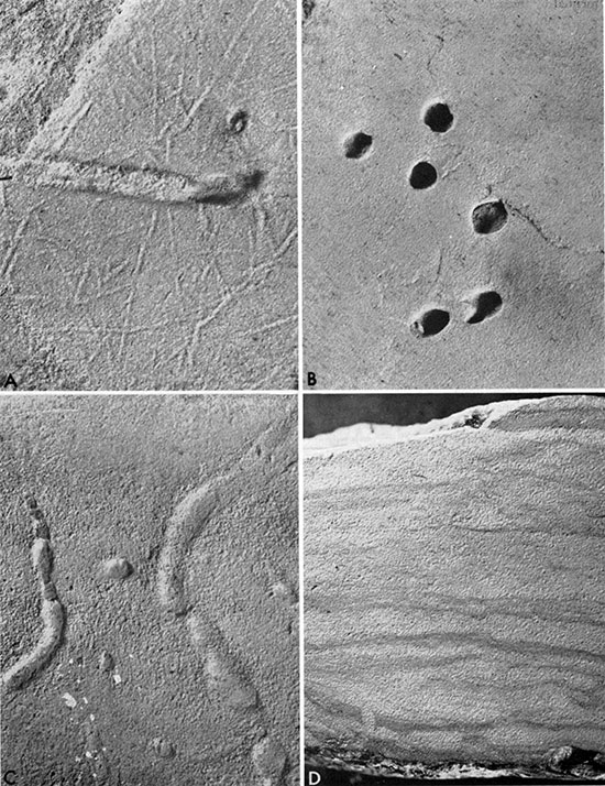
Although much Graneros sand and silt occur as laminae or very thin beds and lenses scattered through shale units (Fig. S, A, B), numerous sandstone and siltstone bodies are sufficiently distinct to be described individually. The range in thickness for such bodies is 0.05 to 8.9 feet, averaging 0.79 foot for 70 measurements. The predominating colors of fresh rock, in order of importance, are light olive-gray, 5Y6/1 being three times as common as 5Y5/2, yellowish-gray (5Y7/2), and various other shades of gray and olive-gray. Weathered rock is most commonly dark yellowish-orange, followed by yellowish-gray (5Y7/2), light brown (5YR5/6), dusky yellow, moderate yellowish-brown and several other colors of minor importance including shades of brown, red, yellow, and orange. Bedding is nearly everywhere thin to very thin, but beds of medium thickness were recorded at 4 localities, and at one place (Loc. 31) a single thick bed was measured. Thin to very thin lenses of sandstone or siltstone are present in 10 sections, nine of which contain lenses composed of a distinctive variety of very fine, silty sandstone or sandy siltstone that is described in some detail below. Laminae and thin laminae of sandstone are of minor importance. Cross lamination is common in noncalcareous sandstone; dips commonly are gentle, but locally are as great as 26 degrees (Fig. 6, A). Very fine silty sandstone of the kind alluded to above occurs here and there in the lower part of the Graneros from Russell County to Ford County, Kansas, and in the upper part of the formation at Locality 17. The sandstone occurs mostly as zones of lenses that project from the slope and commonly weather so as to produce platy float (Fig. 6, B). One zone of such lenses is widely traceable in Russell County. This variety of rock is light olive-gray (5Y6/1) to yellowish-gray (5Y8/1) and is colored yellow by jarosite. The lenses are thinly laminated to gently cross laminated and are interpreted as starved current ripples. Large numbers of long, slender worm castings about one-half millimeter in diameter are peculiar to lenses of this lithology at Localities 5, 14, and 17, and other varieties of ichnofossils are common (Fig. 7, A-D).
Figure 6--Features of noncalcareous sandstone in the Graneros Shale. A, Cross laminations in sandstone from near base of formation in sec. 35, T 12 S, R 14 W, Russell County (Loc. 1), X2. B, Lenses of jarositic silty sandstone near middle of Graneros in sec. 19, T 15 S, R 15 W, Russell County (Loc, 5). These are probably starved current ripples. C, Plastic flow structure in sandstone near middle of formation in sec. 7, T 13 S, R 14 W, Russell County (Loc, 6).
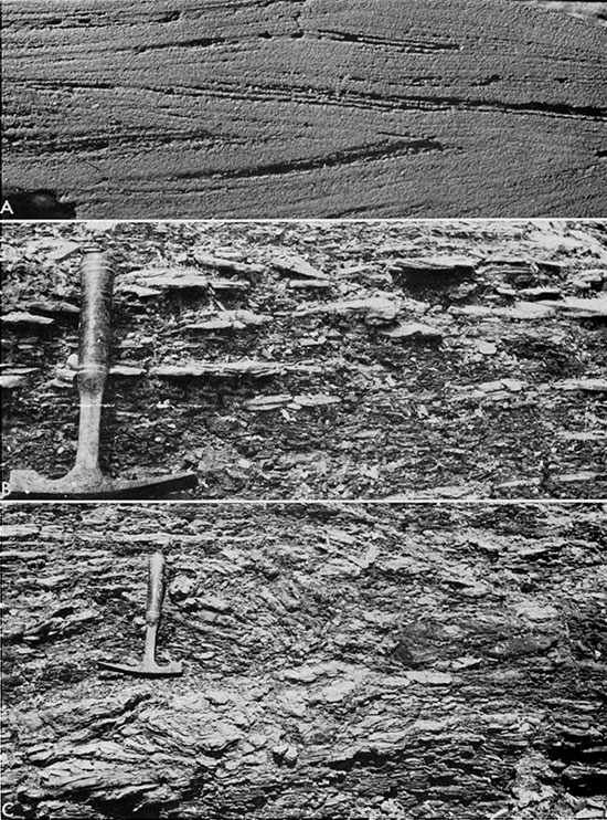
Figure 7--Ichnofossils in noncalcareous sandstone of the Graneros Shale. A, Worm castings in jarositic silty sandstone from near middle of Graneros in sec. 19, T 15 S, R 15 W, Russell County (Loc. 5), X2. B, Worm burrows ( Arenicolites ) in jarositic silty sandstone from ncar top of Graneros section exposed in sec. 11, T 24 S, R 23 W, Hodgeman County (Loc, 25), X2. C, Worm' castings in iarosiric silty sandstone near middle of Graneros in sec. 19, T 15 S, R 15 W, Russell County (Loc. 5), X2. D. Endobenthonically disturbed laminae in argillaceous siltstone from lower part of Graneros in sec. 10, T 25 S, R 23 W, Ford County (Loc. 23), X 1 1/2.
Cementation of sandstone and siltstone bodies is most commonly poor and the rock soft and friable; in a few exposures the rock can be described as noncemented. Only three-fifths as common are exposures of sandstone or siltstone that is fairly well cemented, and some of this is also friable. Well-cemented rock was observed in only one-sixth of the exposures of sandstone or siltstone beds studied. Cement, where present, is mostly limonite or jarosite, but in a few places it consists largely of sparry gypsum. Clayey matrix is the binding agent in some of the sandstone, 18 occurrences of argillaceous sandstone being recorded at 14 localities. Interbeds or laminae of shale are commonly scattered through sandstone and siltstone bodies. Despite the relative softness of noncalcareous sandstones and siltstones in a majority of exposures, most units are sufficiently resistant to erosion to form projecting ledges on weathered slopes. Primary inorganic sedimentary structures other than those mentioned above include 10 occurrences of ripple marks (three oscillation, one interference, two current, four indeterminate), eight occurrences of starved current ripples, all in very fine silty sandstone or sandy siltstone, two occurrences of groove casts, two of load casts, four of subaqueous plastic flow structure (Fig. 6, C), and two of indeterminate sole markings.
In addition to quartz, minerals identified in the field include glauconite, limonite, jarosite, gypsum, and rare muscovite and heavy minerals. Because of its fine grain size, glauconite was identified in only seven exposures of noncalcareous sandstone or siltstone beds, but among 16 thin sections, was recorded in 10 additional places indicating much wider distribution than is apparent in the field. In nearly half of all exposures of sandstone and siltstone beds examined, the rock ranges from more or less stained by to tightly cemented by limonite. In a few exposures, such units, in addition to the silty sandstone already described, are jarosite stained, and here and there limonite and jarosite occur together. In well over half of all studied exposures these rocks are variously stained or cemented by these two iron compounds. Gypsum, mostly in the form of selenite crystals up to a few millimeters in length, was observed in 13 percent of the exposures of sandstone units. Very fine flakes of muscovite were observed at only two localities in the field and a concentration of heavy minerals was noted at only one locality.
Carbonaceous material in the form of minute specks requiring hand-lens identification, larger coarse sand- and granule-sized flakes of carbonized organic matter readily distinguished by the unaided eye, or small pebble-sized plant scraps and chunks of wood were recorded in nearly half of all exposures of noncalcareous sandstone.
Size analysis by sieving was accomplished for six noncalcareous sandstone and two siltstone samples, the selection of which was controlled largely by freshness of the rock and paucity of cement (Table 3). Five additional samples collected at or near the top of the Dakota were sieved for comparison. The results are given in percentages for Wentworth size classes. Except for siltstone samples, all the samples are fine to very fine silty sandstone.
Table 3--Sieve analyses of sandstone and siltstone samples from the Graneros Shale and the Dakota Formation. Fractions are given as percent of total.
| Sample | Coarse sand 1.0-0.5 mm |
Medium sand 0.5-0.25 mm |
Fine sand 0.25-0.125 mm |
Very fine sand 0.125-0.062 mm |
Silt and clay <0.062 mm |
|---|---|---|---|---|---|
| KG-1-E* | 0.22 | 3.49 | 71.65 | 9.03 | 15.61 |
| KG-1-G* | 0.29 | 0.88 | 19.94 | 34.95 | 43.94 |
| KG-1-K | 0.59 | 48.17 | 51.24 | ||
| KG-2-T | 3.27 | 73.25 | 15.50 | 7.98 | |
| KG-2-K | 2.69 | 62.57 | 22.79 | 11.95 | |
| KG-8-G | 0.08 | 0.38 | 65.67 | 33.85 | |
| KG-8-I | 0.20 | 2.23 | 22.19 | 75.38 | |
| KG-12-A* | 0.1 | 0.82 | 31.53 | 36.33 | 21.22 |
| KG-16-E | 0.20 | 1.08 | 28.64 | 43.50 | 26.58 |
| KG-20-B* | 7.75 | 78.28 | 8.8 | 5.17 | |
| KG-20-J | 0.60 | 0.92 | 25.71 | 37.79 | 34.98 |
| KG-23-C* | 0.92 | 22.39 | 32.00 | 44.69 | |
| KG-27-D | 0.36 | 54.10 | 32.06 | 13.48 | |
| *Samples collected at or near the top of the Dakota Formation. | |||||
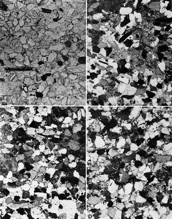
Thin sections were cut from 12 samples of noncalcareous quartzose sandstone and four of sandy quartzose siltstone (Fig. 8). The dominant grain size is very fine sand in eight thin sections and fine sand in four thin sections. No observed quartz grains are larger than medium sand, and silt was sparse in only two sandstone thin sections. Coarse silt dominates the siltstone thin sections (Fig. 8, A), the remaining grains being mostly of very fine sand size. Grain shape in all thin sections shows a wide range from angular to rounded or well rounded, with the modal shape falling generally in the subrounded category.
Figure 8--Photomicrographs of thin sections of noncalcareous sandstone and siltstone. A, Siltstone from upper part of Graneros at Locality 8. Dark areas are limonite. Plane-polarized light, X75. B, Jarosite-cemented silty sandstone from near middle of Graneros at Locality 5. Crossed nicols, X75. C, Gypsum-cemented sandstone from lower part of Graneros at Locality 1. Note bone fragment (gray) in lower right. Plane-polarized light, X75. D, Argillaceous siltstone from lower part of Graneros at Locality 23. Original day laminae disturbed by burrowing organisms. Crossed nicols, X75.
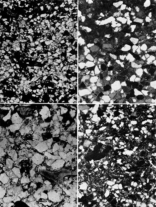
Postdepositional modification of quartz grains commonly renders determination of original grain shape difficult. In most thin sections the rock is well packed; the grain arrangement and relatively large number of contacts per grain are in large measure the result of intrastratal solution. Quartz-grain margins in eight of the 12 sandstone thin sections are notched or pitted owing to the effects of solution and in all but two sandstone and siltstone thin sections, many quartz grains are tightly nestled together because of solution. In several thin sections, pyrite, limonite, or a thin film of highly birefringent material (possibly jarosite) surrounds or appears to invade quartz grains along notched or crenulated contacts that suggest replacement phenomena. Sutured quartz-grain contacts were observed in only two sandstone thin sections.
The dominant constituent in all 16 thin sections is quartz which, together with chert, makes up more than 95 percent of the land-derived detritus in the rocks. In the classification of McBride (1963, p. 667), the sandstones would be called "quartzarenites" and the siltstones, by extension of this classification, "quartzsiltites." Undulatory extinction was observed in a few grains in most of the slides and polycrystalline quartz is common in most of the thin sections. Chert was identified in about half of the slides, and sparingly in each of these. Feldspar was identified in all but one thin section and includes, in one slide or another, orthoclase, microcline, perthite, and plagioclase. Rare grains of heavy minerals, including tourmaline, zircon, and leucoxene, were identified in most slides but, except for leucoxene, each mineral is generally represented by less than a half dozen grains per slide. Muscovite and/or biotite were detected in about half of the thin sections, but these minerals are not common constituents of the rocks. Rock fragments were identified in some sections, but are rare. Glauconite, generally as rounded to well-rounded pellets, but in some slides also as irregular (crushed?) grains, was noted in 13 of the thin sections. Few of these pellets contain evidence of shrinkage cracks. The glauconite is mostly bright green under plane-polarized light. Compatibility of grain size with that of surrounding grains and rarity of desiccation cracks suggest that this may be allocthonous glauconite. Organic grains in the thin sections are nearly all fragmentary remains of fish bones and teeth that are clear to amber colored under plane-polarized light and that are commonly filled or replaced by pyrite or its oxide, reddish-brown limonite. Bits of carbonized plant debris and, in one thin section, possible coprolites are the only other organic remains recognized in thin section.
Cement in these thin sections consists mostly of limonite or jarosite (Fig. 8, B), which coats grains thinly or locally fills interstices in some slides. Some of the cement identified as limonite may be limonitic clay. Sparry gypsum is a cementing agent in two thin sections from Locality 1 and one from Locality 3 (Fig. 8, C). Siliceous cement is scattered sparingly through one dominantly limonite-cemented thin section from Locality 20. Organically disturbed, irregular laminae of clay aid in binding siltstone in two thin sections (Fig. 8, D).
Point-count analyses, based on 200 points per slide, were prepared for 10 sandstone thin sections; these data are listed in Table 4.
Table 4--Analyses of quartzose sandstone thin sections, based on a count of 200 points.
| Sample | Quartz | Polycrystalline quartz |
Chert | Glauconite | Feldspar | Muscovite | Biotite | Tourmaline | Zircon | Leucoxene | Bone | Organic matter |
Limonite | Cement | Other constituents |
||
|---|---|---|---|---|---|---|---|---|---|---|---|---|---|---|---|---|---|
| Limonite | Jarosite | Gypsum | |||||||||||||||
| KG-31-C | 94.0 | 0.5 | P | P | 2.5 | 1.5 | 1.0 | 0.5 | |||||||||
| KG-16-E | 91.5 | 0.5 | P | P | P | P | P | P | 1.0 | P | 0.5 | 0.5 | 6.0 | ||||
| KG-20-N | 71.0 | P | P | 1.0 | P | P | P | P | 1.0 | 2.0 | 1.5 | 23.0 | 0.5 | ||||
| KG-20-N* | 91.5 | 0.5 | 0.5 | 1.5 | 0.5 | P | P | P | 1.0 | 2.0 | 2.0 | 0.5 | |||||
| KG-14-B | 90.0 | 1.0 | P | 0.5 | P | P | P | 2.5 | 1.0 | 0.5 | 4.5 | ||||||
| KG-27-D | 89.0 | 3.0 | 0.5 | 1.5 | P | P | 0.5 | 5.0 | P | ||||||||
| KG-40-M | 82.5 | 2.0 | 1.5 | 6.5 | 0.5 | P | P | P | 2.0 | P | 3.5 | 1.0 | |||||
| KG-5-I | 79.5 | 2.0 | 2.0 | 0.5 | P | 0.5 | 0.5 | 14.0 | 1.0 | ||||||||
| KG-1-M | 79.0 | 1.0 | 0.5 | 4.0 | P | P | P | P | P | 2.5 | 0.5 | 0.5 | 1.5 | 4.5 | 1.5 | 4.5 | |
| KG-1-I | 63.5 | 0.5 | 0.5 | 0.5 | 1.5 | 3.0 | 1.5 | 5.0† | 12.0 | 12.5 | 1.0 | ||||||
| KG-8-G | 61.0 | 4.5 | 1.0 | 10.5 | 1.0 | P | P | 1.5 | 0.5 | 16.5 | 3.0 | 0.5 | |||||
| KG-8-G* | 75.0 | 4.5 | 1.0 | 11.5 | 1.0 | P | P | 1.5 | 05 | 4.0 | 1.0 | ||||||
| *200 points not including limonitic cement. †Includes 2.0% pyrite that has not been oxidized to limonite. P = Present. |
|||||||||||||||||
Animal remains or traces were observed in noncalcareous sandstone and siltstone exposures at approximately three-fourths of the localities containing such rocks. These fossils, listed according to decreasing number of localities at which each was observed, include fish remains, Callistina, Exogyra, worm? castings, Inoceramus and Discinisca, vertical sand- or silt-filled burrows and Ostrea, Lingula, and Parmicorbula?. Except for fish remains, Callistina at Locality 5, Ostrea at Locality 18, and Discinisca at Localities 3 and 20, all these fossils are represented by molds. Discounting fragmentary fish remains, Callistina, occurring at more than half of these localities, is most abundant and characteristic of the fossils. In sandstone beds at six localities scattered across the entire outcrop, molds of this clam are so abundant as to be in contact with one another. Exogyra is generally sparse, but occurs with Callistina in eight of the nine recorded localities. More than 100 brachial valves of Discinisca were collected at Locality 3, but this genus is rare elsewhere. The remaining macroinvertebrate forms are uncommon and of scattered occurrence. Lingula was recorded only at Localities 28 (in sandstone) and 23 (in siltstone); Ostrea was identified in noncalcareous sandstone at Localities 18, 43, and 46, where it occurs sparsely in association with Callistina.
Calcareous Sandstone and Siltstone
[Calcareous rocks containing 50 percent or more sand-sized terrigenous detritus when deposited.]
Beds of calcareous sandstone and siltstone lie in the middle part of the Graneros Shale at many localities, particularly in the Saline and Smoky Hill River areas. At Localities 7, 21, and 37, such beds occur as low in the formation as 4.7, 5.0, and 2.5 feet above the base, respectively. At Locality 9 calcareous sandstone lenses lie within the uppermost foot of the formation but at all but one other locality such rocks lie more than S.6 feet below the top of the Graneros. The fresh rock is most commonly light olive-gray (5Y6/1) or medium-gray, less commonly medium-dark gray or darker shades of olive-gray (5Y5/1-5Y4/1). The color of partly weathered rock is light olive-gray (5Y5/2) and locally dark yellowish-orange, moderate yellowish-brown, or medium yellowish-brown. Well weathered calcareous sandstone is mostly dark yellowish-orange, much less commonly moderate yellowish-brown or light brown (5YR5/6) and locally grayish-orange or yellowish-gray. Individual measured units of calcareous sandstone and siltstone range from 0.1 (Loc. 9) to 3.1 (Loc. 7) feet in thickness, averaging 0.73 foot for 30 measurements. Such beds are relatively resistant, usually projecting prominently from weathered slopes. The rocks range from poorly to tightly cemented, depending in part upon degree of weathering and in part upon degree of original cementation, thus some are. soft and friable, others hard and brittle. The latter condition is more common. Calcareous sandstone and siltstone units are mostly thin to very thin bedded but medium beds were measured at two exposures (Locs. 2 and 5). Among 30 described units, 20 are thinly laminated and 19 of these are gently cross laminated and locally cross bedded with a dip as great as 18 degrees (Fig. 9, A).
Ripple marks were observed in calcareous sandstone at Localities S, 7, 21, 36, and 46 (Fig. 9, B). Subaqueous plastic flow structure was recorded in two units at Locality 5 and in one unit at Locality 39, and sole marks including load casts and casts of tool marks (Fig. 9, C) were recorded at Localities 9, 21, 39, and 43. Other structures in these rocks include worm castings, worm burrows, arthropod trackways (Fig. 9, D; 10, A), concretions and nodules, but none of these are common except for the ichnofossils which occur in calcareous siltstone at Localities 5 and 43.
Figure 9--Features of calcareous sandstone in the Graneros Shale. A, Cross-bedded sandstone from bed near middle of formation in sec. 19, T 15 S, R 15 W, Russell County (Loc. 5). B, Oscillation ripple marks from bed near middle of formation in sec. 20, T 15 S, R 15 W, Russell County (Loc. 5). C, Tool-mark casts on underside of sandstone slab from bed near middle of Graneros in sec. 26, T 15 S, R 16 W, Ellis County (Loc. 21). (Same unit as A and B.) Scale is one-cent coin. D, Worm burrows in sandstone from upper part of Graneros in sec. 20, T 15 S, R IS W, Russell County (Loc. 5), X 1 1/4.
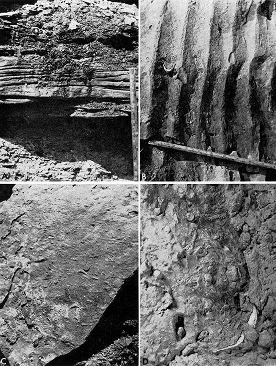
Figure 10--Organic features of calcareous rocks in the Graneros Shale. A, Arthropod trackway (lower) and unidentified ichnofossils in calcareous silty sandstone near middle of formation in sec. 36, T 12 S, R 11 W, Russell County (Loc. 43), X2. B, Arthropod trackways in skeletal limestone from upper part of Graneros in sec. 20, T 15 S, R 15 W, Russell County (Loc. 5), X 1. C, Coquinoidal limestone consisting largely of Callistina, from lower part of Graneros in sec. 20, T 15 S, R 15 W, Russell County (Loc. 5), X2. D, Coquinoidal limestone, consisting largely of Ostreaa beloti, from upper part of Graneros Shale in sec. 4, T 12 S, R 15 W, Russell County (Loc. 15). Scale is one-cent coin.
Fossils were observed in most exposures of calcareous sandstone, the most common remains being fish teeth, bones, and scales. Ostrea, usually preserved as original shell material, was recorded in calcareous sandstone at 13 of the 22 exposures containing this rock. Next, in order of wideness of distribution, are Inoceramus, as shell scraps and/or isolated prisms or prism molds, Callistina, and Exogyra. The last two, preserved as both molds and shell material, have not been observed in association with Ostrea. A single Discinisca was collected at Locality 39 from calcareous sandstone containing Callistina and Exogyra. Small fragments and specks of carbonized plant debris were noted locally in these rocks. Arenicolites is abundant in one bed of calcareous siltstone lying 12.9 feet above the base of the Graneros at Locality 5 (Fig. 9, D).
All of the calcareous sandstones were classed in the field as fine- to very fine-grained sandstone. Some beds are notably silty, a few are argillaceous, and others contain thin laminae of silty shale. Bedded calcareous siltstone occurs at Locality 5, as noted above, and lenses of calcareous siltstone lie 12.6 feet above the base of the Graneros at Locality 43. Fresh calcareous sandstone has a petroliferous odor at a few localities; weathered rock is commonly selenitic.
Ten thin sections were cut from nine representative samples classed as calcareous sandstone (Fig. 11). In all but one of these thin sections the dominant size of quartz grains is very fine; all contain some coarse silt and fine sand. Shape of quartz sand grains ranges from angular to well rounded in all thin sections, with subrounded being the most common shape. Packing ranges widely also, depending in part upon degree of intrastratal solution, which increases the number of contacts per grain. The usual number of contacts per grain in these thin sections is 1 or 2, but in a single section one can observe a range from 0 to 5 contacts per grain. Contacts of quartz against quartz are commonly embayed or nestled so as to suggest solution along mutual surfaces but no suturing is evident.
Figure 11--Photomicrographs of thin sections of calcareous sandstone. A. Sandstone from near middle of Graneros at Locality 5 showing Inoceramus prisms (note grains with conspicuous cleavage in lower part of photo), fish remains (dark parallel-sided grains), and glauconite (dark rounded grains at right). Plane-polarized light, X75. B. Sandstone from upper part of Graneros at Locality 21 showing large areas of optically continuous calcite cement. Note replacement of quartz by calcite directly below fish fragment (black rodlike grain) in left center. Crossed nicols, X75. C, Sandstone from upper pan of Graneros at Locality 5 showing large areas of optically continuous calcite cement. Note calcite replacement of quartz-grain borders in center of photograph. Crossed nicols, X75. D. Sandstone from lower part of Graneros at Locality 23. Note large glauconite grain (dark-gray) just left of center of photograph and lack of optical continuity of cement through large areas of rock. Crossed nicols, X75.
Calcareous cement ranges widely in kind from a scattering of microspar that effects only a weak cementation to sparry calcite that is optically continuous through large areas of rock and that effects a tight and thorough cementation. In sample KG-12-I, nearly one-fifth of the cement consists of coarse silt-sized dolorhombs that probably represent recrystallized sparry calcite. The latter cement nowhere shows fringing growth such as would result from the granular cementation as described by Bathhurst (1958, p. 14), but in three thin sections it is locally in optical continuity with Inoceramus prisms suggesting that the sparry calcite originated by rim cementation (Bathhurst, 1958, p. 21). Quartz grains in all but one thin section commonly have irregularly crenulated borders where the quartz has been replaced by calcite, which deeply invades the margins of some quartz grains.
Invertebrate remains in thin sections consist largely of isolated Inoceramus prisms and shell fragments. Prisms are locally optically continuous with surrounding cement, as mentioned above, and in two thin sections the edges of prisms and shell fragments are highly sutured where partly invaded by interstitial calcite. In one thin section Inoceramus prisms were recrystallized; in another section a few prisms were partly replaced by transverse bands of gypsum. Fish bones and scales are mostly fragmentary, of amber or yellow color under plane-polarized light, and bones are commonly replaced in part by very finely crystalline pyrite, some of which is oxidized to limonite (Fig. 11, A). Each of the thin sections contains glauconite, all of which is green, most of which occurs as well-rounded pellets, and some of which occurs as irregularly shaped or even angular grains. Shrinkage cracks are rare in these pellets. Some of these pellets are replaced by pyrite in sample KG-5-J. Pyrite occurs as spherical blebs in addition to modes of occurrence already described. Limonite occurs in the same modes as pyrite, originating by oxidation of the latter, and also is disseminated through cement of some thin sections as a cloudy reddish-brown stain, and fills foraminifers in two thin sections. Whitish blebs of isotropic material in seven thin sections are probably leucoxene. In two thin sections clay occurs as a rimlike coating around many quartz grains and locally has invaded quartz grains, apparently along replacement contacts. Other minerals identified in these thin sections include polycrystalline quartz, chert, plagioclase, orthoclase, microcline, tourmaline, zircon, leucoxene, muscovite, and biotite. Except for polycrystalline quartz each of these minerals is represented in the slides where present by only 1 to 5 grains, and in no slide did I observe the entire suite.
Table 5--Point-count analyses of calcareous sandstone thin sections, listed in order of decreasing percentage of quartz. Based on a count of 200 points.
| Sample | Quartz | Inoceramus prisms |
Shell fragments |
Bones, scales, teeth |
Glauconite | Chert* | Mica | Leucoxene | Pyrite | Limonite | Sparry calcite cement |
Calcite replacing quartz |
Recrystallized calcite |
Other constituents |
|
|---|---|---|---|---|---|---|---|---|---|---|---|---|---|---|---|
| KG-31-E | 86.5 | 2.5 | 2.0 | 8.0† | 1.0 | ||||||||||
| KG-21-J | 64.0 | 3.0 | 0.5 | 2.0 | 0.5 | 0.5 | 1.0 | 1.0 | 0.5 | 21.5 | 5.0 | 0.5 | |||
| KG-5-L-1 | 63.5 | 2.0 | 1.0 | 0.5 | 1.0 | 1.0 | 2.0 | 24.0 | 3.0 | 2.0 | |||||
| KG-23-L | 56.0 | 0.5 | 1.0 | 6.5 | 1.0 | 1.5 | 0.5 | 1.0 | 29.5 | 2.0 | 0.5 | ||||
| KG-5-J | 45.5 | 5.0 | 2.5 | 0.5 | 2.5 | 1.5 | 40.0 | 2.5 | |||||||
| KG-7-O | 45.5 | 6.0 | 0.5 | 1.5 | 0.5 | 1.5 | 41.0 | 3.5 | |||||||
| KG-12-I‡ | 44.5 | 5.5 | 2.0 | 2.5§ | 34.0 | 1.5 | 9.5|| | 0.5 | |||||||
| KG-7-I | 38.0 | 5.0 | 1.5 | 1.0 | 0.5 | 1.5 | 3.5 | 45.5 | 3.0 | 0.5 | |||||
| KG-17-K | 28.5 | 19.0 | 1.5 | 1.0 | 1.0 | 3.0 | 0.5 | 3.5 | 35.5 | 5.5 | 0.5 | 0.5 | |||
| *Includes polycrystalline quartz. † Microspar. ‡ Count ignores disseminated limonite which masks identity of grains. § Limonite in slide may be partially concentrated in interstitial clay. || Dolorhombs. |
|||||||||||||||
Point-count analysis of calcareous sandstone, based on 200 points per thin section, is tabulated in Table 5. Although technically a limestone, Sample KG-17-K is considered as a calcareous sandstone on the basis of its composition before diagenesis. A marked inverse relationship exists between percentage of quartz grains and amount of cement. A rock with a few percent less quartz grains and correspondingly more Inoceramus prisms than KG-17-K would be classed as a skeletal limestone.
Skeletal Limestone
Limestone lenses or beds consisting largely of Inoceramus prisms and shell fragments, and ranging in thickness from less than 0.1 foot to 0.4 foot, are scattered sparingly through the upper 12.5 feet of the Graneros Shale. Except for Locality 31, such beds were observed only in the Smoky Hill and Saline River drainage basins of Russell, Ellsworth, and Lincoln counties. Although the limestone is composed dominantly of fine- to very fine-grained fossil fragments, most of the beds contain rudaceous organic debris including whole or fragmentary remains of Inoceramus and Ostrea. Remains of the latter are commonly concentrated at the top of the bed. Inoceramite is an informal field designation for such limestone, and the most descriptive term for such rocks is biofragmental calcarenite, but in view of current trends in carbonate rock classification, the term "skeletal limestone" (Leighton and Pendexter, 1962) is used herein. By increase. in proportion of quartz relative to shell fragments and Inoceramus prisms, the skeletal limestone lithology is transitional with that of calcareous quartzose sandstone.
The fresh rock is mostly light olive-gray (5Y5/2) to olive-gray (5Y4/1) and weathers dark yellowish-orange, various shades of yellowish-brown, or grayish-orange. Skeletal limestone units are thin to very thin bedded; individual beds are thinly laminated and locally gently cross laminated at several localities. Such cross laminations may be related to ripple marking, but obvious ripples were noted in skeletal limestone only at Locality 32. Sole marks, including drag marks, load casts, or worm?-trail casts, were observed in skeletal limestone beds at Localities 1, 5, and 15, and arthropod tracks are common in skeletal limestone near the top of the Graneros at Locality 5 (Fig. 10, B). Most of the rock is well cemented where fresh and relatively resistant to erosion; beds of skeletal limestone usually project as ledges from slopes of Graneros exposures. When freshly broken, these rocks commonly emit a petroliferous color.
Inoceramus remains are ubiquitous in skeletal limestone beds, and Ostrea and fish remains are present in most exposures. Fish remains were observed in a majority of exposures and probably occur in all of these rocks. Rare fossils in skeletal limestone include molds of ammonites (Locs. 5 and 8), Callistina (Loc. 1), and a cirriped plate (Loc. 32).
A suite of eight thin sections was cut from skeletal limestone samples collected at five localities (Fig. 12). Seven of these sections were analyzed by point-counting. Point-count data are summarized in Table 6. The dominant primary constituent in each of these sections is isolated Inoceramus prisms which make up 35 to 50.5 percent of the thin sections studied. Scattered fragments of Inoceramus and Ostrea valves constitute from 2.5 to 19 percent of thin-sectioned rock. Maximum diameters of the Inoceramus prisms lie dominantly in the fine and very fine sand ranges but many are of coarse-silt size.
Figure 12--Photomicrographs of thin sections of skeletal limestone. A, Limestone from upper part of Graneros at Locality 21 showing large areas of optically continuous calcite cement. Note fish remains (large elongate grains) and scattered quartz grains. Crossed nicols, X75. B, Limestone from upper part of Graneros at Locality 1 showing partial replacement by pyrite of fish remains and Inoceramus prisms. Crossed nicols, X 75. C, Limestone from near top of Graneros at Locality 1 showing dominance of Inoceramus prisms. Plane-polarized light, X75. D, Concretionary skeletal limestone from upper part of Graneros at Locality 33. Note partially recrystallized borders of Inoceramus prisms. Crossed nicols, X75.
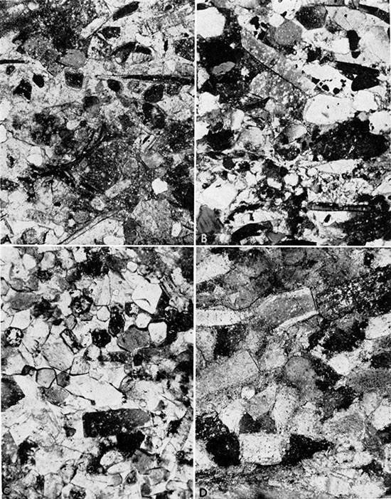
Table 6--Point-count analyses of skeletal limestone thin sections, based on a count of 200 points.
| Unit | Inoceramus prisms |
Shell fragments |
Sparry calcite cement |
Bones, teeth, scales |
Quartz | Pyrite | Limonite | Glauconite | Other constituents |
|---|---|---|---|---|---|---|---|---|---|
| KG-1-O | 43.0 | 9.5 | 34.0 | 2.5 | 8.0 | 1.0 | 1.5 | 0.5 | |
| KG-1-Q | 37.0 | 7.0 | 30.0 | 8.0 | 13.0 | 2.5 | 1.5 | 0.5 | 0.5 |
| KG-1-R | 38.5 | 19.0 | 34.0 | 4.0 | 1.0 | 3.0 | 0.5 | ||
| KG-1-U | 45.0 | 15.5 | 35.0 | 1.0 | 1.0 | 2.5 | |||
| KG-8-M | 50.0 | 3.5 | 33.0 | 8.0 | 4.0 | 1.0 | |||
| KG-15-A | 35.0 | 17.0 | 41.0 | 1.0 | 4.5 | 0.5 | 0.5 | 0.5 | |
| KG-21-O | 37.0 | 2.5 | 41.0 | 7.0 | 9.5 | 3.0 |
Most of the prisms are less than a millimeter in length. Fish remains, including bones, teeth, and scales, constitute from 1 to 8 percent of the thin sections examined. In all thin sections, the Inoceramus prisms and elongated fragments of Inoceramus, Ostrea, and fish remains are mostly arranged parallel to or at only a small angle to the bedding.
Quartz grains, which are present in all skeletal limestone thin sections are chiefly of very fine sand size but the range is from coarse silt to fine sand. These grains constitute from 1 to 13 percent of the sections studied. Quartz grains range from angular to well-rounded but most are subangular. In all of these thin sections some of the quartz grains are partially replaced peripherally by calcium carbonate. Irregular-shaped to well-rounded pellets of glauconite are present in all of the thin sections, ranging in abundance from a small fraction of 1 percent to apparently as much as 1.5 percent of the rock. A few of the pellets contain desiccation cracks, and in a sample from Locality 31, some of the grains are extensively replaced by limonite. Pyrite or limonite or both minerals are common in all of the thin sections, making up from 1 to 4 percent of the grains counted. Pyrite occurs as spheroidal blebs, as a shell-replacement mineral, or as fillings in vesicular parts of bones and teeth. Limonite occurs in the same three forms, pseudomorphous after pyrite, and is disseminated interstitially as a stain in sparry calcite cement in a few sections; locally it has replaced glauconite grains and Inoceramus prisms.
The cement in calcarenite thin sections is wholly of sparry calcite as crystals that are commonly in optical continuity through large areas of the rock (Fig. 12, A). Inoceramus prisms are mostly in sharp contact with the cement in all thin sections save one, in which many of the prism-cement contacts are sutured. In three thin sections a few Inoceramus prisms were observed to lie in optical continuity with the enclosing cement. Sparry calcite cement constitutes from 30 to 41 percent of the thin sections studied.
White spheroidal pellets, seemingly composed of phosphatic material, were observed under reflected light in each of the specimens that were sectioned. Only a dozen measurements were made, owing to paucity of such structures, but a general size range from 0.18 to 1.5 mm was determined. The pellets are concluded to be of fecal origin. Scraps of carbonized wood were observed under reflected light in four of these samples.
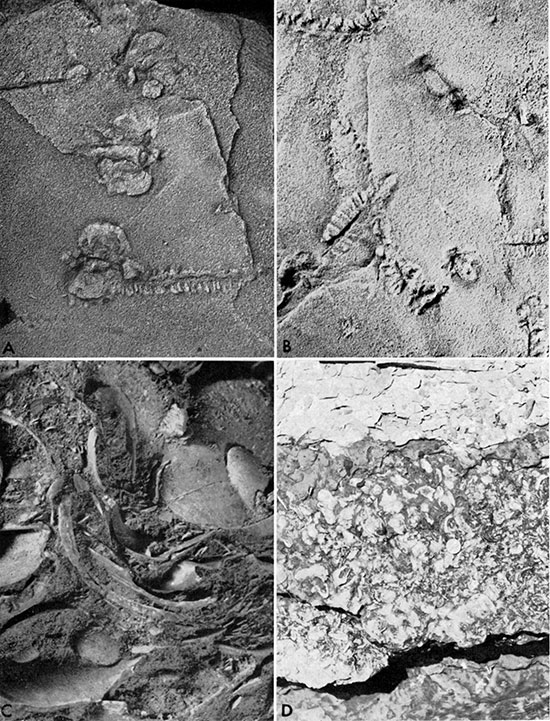
Graneros rocks composed mainly of skeletal debris and also containing large numbers of whole invertebrate shells or conchs are quantitatively unimportant but paleontologically of great significance. These rocks are a coquinoidal variety of skeletal limestone formed very locally under conditions of much greater energy expenditure than the more fine-grained skeletal limestones described above. In the lower part of the Granercs such rock occurs only at Locality 5, in southwestern Russell County, where abundant whole and broken shells of Callistina and Exogyra make up most of a lens that was approximately 0.4-foot thick and 6 feet wide (Fig. 10, C). Many of the shells are standing on edge in imbricate fashion, and some Callistina valves are paired. The shells are set in a calcite-cemented matrix consisting largely of prisms and small shell fragments of Inoceramus; the uppermost and lowermost parts of the lens consist of calcareous quartz silt, some of which exhibits conein-cone structure. This block of limestone has yielded specimens of nearly all the species of macroinvertebrates that occur in the lower part of the Graneros and includes some species not known elsewhere in the formation. My attempts to disaggregate pieces of this block ultrasonically and with a variety of solvents met with limited success.
Coquinoidal limestone in the upper part of the formation is exposed at Localities 32 and 33 in northwestern Ellsworth County. A less fossiliferous exposure of the same bed is at Locality 18. At Locality 32 the unit is represented by a lens 0.8-foot thick, the lower 0.6 foot of which is crowded with fossils including examples of nearly all macro invertebrate species known to me from the upper part of the formation. Except for Ostrea, shell material in most of these fossils has been recrystallized and adheres to enclosing matrix rather than to the internal molds. Many fossils in this limestone were fragmented before burial, breakage being most evident among the large ammonite conchs. The fossils are enclosed in a matrix consisting largely of sparry-calcite-cemented Inoceramus prisms and small shell fragments. The upper 0.2 foot of this limestone lens is very fine grained and bears an outward appearance of concretionary origin but actually consists almost entirely of small Inoceramus prisms which are tightly packed together owing to solution transfer that has left prisms in close contact along interlocking or irregular grain borders. A thin section of similar fine-grained, concretion-like rock from the same unit at Locality 33 (Fig. 12, D) also consists largely of Inoceramus prisms with sutured grain contacts, but individual prisms have suffered less solution and retain more of the original outline than those from Locality 32. Conspicuous lenses of coquinoidal limestone are scattered through approximately 3 feet of shale at Locality 47, directly beneath the thick bentonite marker bed that lies near the top of the Graneros Shale. These lenses consist largely of Ostrea with some Inoceramus shells. A large adult specimen of Plesiacanthoceras was collected from one lens. Similar beds of oyster-rich coquinoidal limestone lie directly beneath the bentonite marker bed at Localities 5 and 15 (Fig. 10, D).
Bone Beds
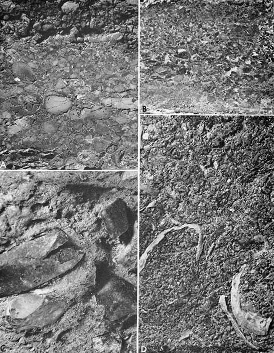
Layers of rock containing conspicuous quantities of bone pebbles are known from Graneros exposures at Localities 3 (Fig. 13, A), 4 (Fig. 13, B), 6, 18 (Fig. 13, C), 28 (Fig. 13, D), 33, 34, 39, and 43. Pebbly units near the middle of the formation at Localities 4, 18, and 34 lie in a similar stratigraphic position and may be related genetically; the same is true for the bone-bearing units at Localities 6 and 28. The bone-pebble bed at Locality 3 (Fig. 13, A) lies near the base of the Graneros and is the same as that at Locality 43. Except for the abundance of fragments or rounded pebbles of bones or teeth, these rocks differ widely from one another. The concentration of vertebrate remains and relatively large size of such constituents suggest similar conditions of origin, so the bone beds are discussed as a group. The bone pebbles, and clay pebbles and coprolites that are associated with them, are commonly pyritized or, by oxidation of pyrite, limonitized (Fig. 13, A). Bone-bed samples all contain coprolites and/or clay pebbles that are difficult to distinguish microscopically excepting those coprolites that contain bone fragments.
Figure 13--Bone-bed samples from the Graneros Shale. A, Weathered gypsum-cemented bone-pebble conglomerate from near base of Graneros in sec. 3, T 13 S, R 11 W, Russell County (Loc. 3), X2. B, Unweathered, gypsum-cemented bone-pebble conglomerate from bed lying near middle of Graneros in sec. 6, T 14 S, R 10 W, Ellsworth County (Loc. 4), X2. C, Bone-pebble conglomerate from lens lying near middle of Graneros in sec. 29, T 15 S, R 10 W, Ellsworth County (Loc. 18), X2. D, Oyster-bearing bone bed in upper part of Graneros in sec. 7, T 13 S, R 9 W, Lincoln County (Loc. 28), x2 1/2.
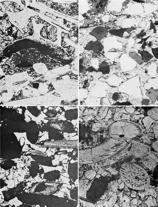
Thin sections of bone-bed samples are illustrated in Figure 14. Vertebrate remains commonly occur as rounded pebbles at all but Locality 28 (Fig. 13, D; 14, A) where more or less elongated fragments are the rule. The gypsum-cemented bone bed at the base of the unit KG-3-L (Fig. 14, B) in the lower part of the Graneros is, like most rocks in that part of the formation, noncalcareous. A similar bone bed lies near the middle of the formation at Locality 4 (Fig. 14, C). Other sectioned bone-bed samples, all from the upper half of the formation, are calcareous and are related mineralogically to calcareous quartzose sandstone or skeletal limestone beds depending upon relative proportions of quartz sand or shell debris, respectively. For example, the bone bed at Locality 34 grades upwards into calcareous quartzose sandstone, but the bone bed at Locality 18 contains 10 percent more shell debris than quartz sand. The bone bed at Locality 6 contains subequal amounts of quartz sand and shell debris (Fig. 14, D).
Cement in bone beds at Localities 3 and 4 is nearly all sparry gypsum that occurs in sharp contact with framework grains. Carbonate cement characterizes the remaining thin sections. In the latter group, sparry calcite occurs as both fine- and coarse-grained cement; in places the cement is optically continuous with Inoceramus prisms and is in optical continuity between several grains. In the thin section from Sample KG-28-H the cement has been largely recrystallized to dolomite. This bed also contains coarse-grained second-generation sparry calcite occurring as veins or lying adjacent to bone fragments. In Sample KG-6-P sparry gypsum surrounding many bone pebbles and coprolites? postdates the sparry calcite cement (Fig. 14, D). In all thin sections. examined the rock is well washed and free of clay. Point counts, based on 200 points per thin section, were made on five samples of bone-bed rock (Table 7).
Figure 14--Photomicrographs of thin sections of bone beds. A, Dolomite-cemented bone bed from upper part of Graneros at Locality 28. Dark areas in cement and large bone fragment (center) are limonite. Plane-polarized light, X50. B, Gypsum-cemented sandstone from bone bed near base of Graneros at Locality 3. Crossed nicols, X75. C, Bone bed near middle of Graneros at Locality 4 showing gypsum cement, quartz grains, rounded bone grains (black), and fish remains (tabular grains, center). Plane-polarized light, X50. D, Calcite-cemented bone bed in upper part of Graneros at Locality 6 showing mixture of fish teeth, quartz grains, and Inoceramus prisms. Note post-calcite gypsum above and below large fish tooth at top left. Plane-polarized light, X75.
Bentonite
The Graneros Shale of central Kansas contains several layers of bentonite, the thickest and most widespread of which lies between 0.5 (Loc. 12) and 3.2 feet (Loc. 18) below the Greenhorn in much of the northern and central parts of the outcrop (Fig. 15, A, B). At Locality 38 in Washington County, shale separating the bentonite from the ill-defined base of the Greenhorn is 4.25 feet thick and is only slightly calcareous in the upper 2.5 feet. At Locality 16, a few miles to the east, beds recognizable as Greenhorn are not exposed but at least 6.0 feet of noncalcareous, Graneros-like shale lie above the bentonite bed. The thick bentonite bed, which has been called the "bentonite marker bed" by Merriam (1957a) ranges in thickness from 0.2 to 1.65 feet, averaging 0.9 foot for 25 measurements. The "fresh" rock is most commonly pale greenish-yellow, yellowish-gray (5Y8/1), or very light-gray, but exhibits a wide range of coloration from bluishgray at one extreme to nearly white at the other. Weathering apparently has not affected the Graneros at Locality 43, as noted above, and part of the exposure at Locality 15 is essentially unweathered. The thick bentonite is light to medium bluish-gray at these localities and is likewise bluish-gray in the subsurface (Merriam, 1957a; Merriam, et al., 1959) where the bed is also unweathered and lies within a calcareous shale sequence. Where long exposed to weathering, the bentonite has been stained by limonite and is usually dark yellowish-orange, but other shades of orange and some of brown have been observed locally. The bentonite is generally very slightly to slightly silty, is commonly speckled with fine flakes of biotite, and locally contains aggregates of finely crystalline pyrite or marcasite less than 1 mm in diameter. Only one fossil, an Inoceramus mold, was observed in the bentonite. The rock is soft and unctuous when wet, is brittle when dry, and breaks with a conchoidal fracture.
Other bentonites in the Graneros range from less than 0.01 to 0.3 foot in thickness, and individual beds show considerable range in thickness at some exposures. None of these layers can be traced with certainty for more than a few miles, probably owing to intermittent scour of the sea floor. Bentonite pinchouts were noted at a few places including Locality 4 where a bentonite near the middle of the formation is truncated by a lenticular bed of bone-pebble conglomerate. A thin bentonite layer that rests on beds or lenses of sandstone lying near the middle of the formation in the Saline and Smoky Hill river areas is a relatively widespread marker bed but its identity would be obscure were it not for association with the subjacent sand unit which was locally deformed as a result of subaqueous plastic flow. Bentonites below the thick marker bed exhibit considerable range in coloration with yellowish-gray (5Y7/2), light olive-gray (5Y6/1), and light-gray being most common, with several other shades of gray next in importance. The dominant weathering color is dark yellowish-orange owing to limonitic staining. Most of these thin bentonite beds are slightly silty, but range from non-silty to finely sandy. Finely divided biotite was observed in a few of these thin bentonite layers and the taste of melanterite was noted in some.
Several samples of bentonite were wetted and examined microscopically. All of the samples contained quartz of detrital, authigenic, or volcanic? origin but no sample contained all three. The authigenic quartz is euhedral; the volcanic? quartz is splintery. Biotite was observed in each of three samples of the bentonite marker bed thus treated, but not in any of the other microscopically studied samples. Two samples contained minute selenite crystals; such crystals are common in weathered bentonite beds. The following minerals were each observed in only one sample of bentonite examined microscopically: pyrite in crystalline aggregates less than 0.5 mm in diameter, feldspar, and glauconite. Relative proportions of major constituents in nine bentonite samples were determined by X-ray diffraction techniques. In four bentonite samples from the upper part of the formation, including two from the bentonite marker bed, the order of mineral abundance is montmorillonite (dominant), kaolinite, and quartz. In all five samples from the lower part of the formation kaolinite is the dominant mineral, montmorillonite and quartz, in either order of abundance, make up most of the remaining rock, and gypsum was detected in two samples. The stratigraphic distribution of kaolinite-dominant versus montmorillonite-dominant bentonites apparently coincides with both paleontologic and lithologic criteria that serve to distinguish the upper and lower parts of the formation.
Table 7--Point-count analyses of bone-bed thin sections, based on a count of 200 points.
| Unit | Bone | Bone* | Other pebbles† |
Quartz | Shell debris‡ |
Sparry gypsum |
Sparry calcite |
Dolomite | Limonite cement |
Pyrite§ | Limonite§ | Other constituents |
|---|---|---|---|---|---|---|---|---|---|---|---|---|
| KG-3-L | 25.0 | 12.0 | 28.5 | 8.0 | 21.0 | 5.0 | 0.5 | |||||
| KG-4-I | 12.5 | 39.5 | 2.0 | 1.0 | 35.5 | 1.0 | 5.5 | 1.5 | 1.5 | |||
| KG-6-P | 20.0 | 9.5 | 11.5 | 15.0 | 7.0 | 4.5 | 31.5 | 0.5 | 0.5 | |||
| KG-18-E | 17.5 | 1.5 | 1.0 | 14.0 | 24.0 | 3.0 | 29.0 | 5.0 | 1.5 | 3.0 | 0.5 | |
| KG-28-H | 33.0 | 9.0 | 2.5 | 4.0 | 3.5 | 0.5 | 15.0 | 29.0 | 3.5 | |||
| * Pyritizcd or limonitized. † Clay pebbles and/or coprolites, many partly or wholly pyritized. ‡Mostly Inoceramus prisms and fragments of Ostrea. § Not obviously replacing bones or other pebbles. |
||||||||||||
Figure 15--Bentonite and concretions in upper part of the Graneros Shale. A, Bentonite marker bed ("X" bentonite) in sec. 4, T 12 S, R 15 W, Russell County (Loc. 15). B, Bentonite marker bed in sec. 35, T 12 S, R 14 W, Russell County (Loc. 1). C, Septarian concretion in upper part of Graneros in sec. 29, T 15 S, R 10 W, Ellsworth County (Loc. 18). D, Clayey carbonate concretions (above pick handle) lying along upper contact of the bentonite marker bed in sec. 36, T 14 S, R 11 W, Russell County (Loc. 34). Note sharp contact of Greenhorn Limestone (top) on Graneros Shale.
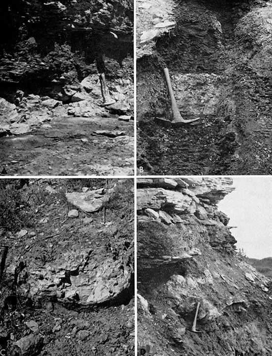
The bentonite marker bed that lies near the top of the Graneros in central Kansas has been traced across the subsurface of western Kansas by Merriam (1957a). This bed, known as the "X" bentonite in Colorado and southeastern Wyoming, has been traced widely in the Denver Basin by Haun (1959, pl. 1 and 2), who noted that this bentonite "can be traced with reasonable certainty to western Colorado." The bentonite is 5 to 16 inches thick in Hamilton County. Kansas, where it lies 10 feet below the top of the Graneros (Bass, 1926, p. 72). In Baca County, southeastern Colorado, the bentonite is 1 foot thick and lies 4.2 feet below the top of the Graneros (McLaughlin, 1954, p. 111). It is 8 to 10 inches thick and lies 13 feet below the top of the formation on the Model Anticline (Bass, et nl., 1947). Scott (1962, p. 12; 1963, p. 95) recognized this bentonite in the Littleton and Kassler auadrangles, near Denver, Colorado, but, on lithologic grounds, concluded that the Graneros-Greenhorn contact lies below the marker bed.
McCrae (1956) traced the "X" bentonite northward from the southeastern corner of Wyoming to the vicinity of Lance Creek, Wyoming, where the bed lies slightly more than 300 feet above the base of the Belle Fourche Shale. About 50 miles to the northeast of Lance Creek a major bentonite lying 325 feet above the base and approximately 15 feet below the top of the Belle Fourche, and which is seemingly correlative with the "X" bentonite, has been reported in a well a few miles southwest of Newcastle, Wyoming, by Mapel and Pillmore (1963, p. 42). They correlate this bed, which in outcrop near Newcastle is 2 feet thick and lies 350 feet above the base and 17 feet below the top of the Belle Fourche, with a northern Black Hills bentonite that has been called "bed F" by Knechtel and Patterson (1962). The latter workers note that in the area east of Alzada, Montana, the base of the Greenhorn is a thin limestone bed that was called the Orman Lake Limestone by Petsch (1949, p. 9). In its type area the Orman Lake consists of shell debris and vertebrate remains and on fresh fracture emits a petroliferous odor (Petsch, 1949, p. 10). This description fits closely that of the basal Lincoln in most areas of central Kansas. Bentonite "bed F" lies 6 feet below the Orman Lake near Belle Fourche, South Dakota, and thus lies in a position comparable to that of the bentonite marker bed of Kansas, but the base of the Greenhorn rises rather abruptly to the west of Belle Fourche, so that in parts of Crook County, Wyoming, "bed F" lies 285 feet below the base of the Greenhorn. Knechtel and Patterson (1962, p. 982) believe that "bed F" may be the same as the Soap Creek bentonite reported by them (Knechtel and Patterson, 1956, p. 18) from near the northeast flank of the Bighorn Mountains, around Hardin, Montana. Plesiacanthoceras amphibolum (Morrow) occurs in beds directly below the Soap Creek bentonite and Acanthoceras? sp. [now known as Plesiacanthoceras wyomingense (Reagan.) 1 occurs in beds directly overlying the Soap Creek bentonite. The same bentcnite is represented in the Frontier Formation in [ohnson County, Wyoming, by 4 feet of bentonite lying between beds containing P. amphibolum and Acanthoceras? sp. (=P. wyomingense), respectively (Hose, 1955, p. 100). In Kansas, P. amphibolum occurs mostly below the bentonite marker bed, but it has been collected above the bentonite at a single exposure (Loc. 8) where specimens lie a maximum distance of 1.8 feet above the marker. Although P. wyomingense has not been recovered from uppermost beds of the Graneros Shale in Kansas, the species does occur in basal beds of the Greenhorn at one locality. Faunal evidence is therefore suggestive, but not conclusive, that the bentonite marker bed and the Soap Creek bentonite are correlative units.
Concretions
Concretionary rock of several kinds was observed in the Graneros Shale at a total of 17 localities in central Kansas. At Locality 7, a nodular layer of light olive-gray (5Y5/2) clay-ironstone concretions 0.25-foot thick lies 4 feet above the base of the formation. The concretions are surficially limonitized. A bed of dark yellowish-orange to moderate reddish-brown clay ironstone 0.5-foot thick lies 2.2 feet above the base of the Graneros at Locality 13. At Locality 23, a hard concretionary layer of olive-gray (5Y6/1) claystone that weathers moderate reddish-brown to dark yellowish-orange lies 0.65 foot above the base of the Graneros. At Locality 40, a 0.4-foot-thick limonitized bed of clay that lies 3.8 feet above the base of the Graneros has a concretionary appearance. The rock is light olive-gray (5Y5/2) and weathers dark yellowish-orange to very dusky red. All other concretions that I saw in the Graneros lie in the upper half of the formation, and most of these are of the calcareous septarian type.
More or less typical septaria, mostly of oblate spheroidal shape, were observed at Localities 18 (Fig. 15, C), 33, 43, and 47. In these concretions the matrix is dark greenish-gray, weathering at Locality 18 to moderate yellowish-brown and moderate red. The veins are grayish-yellow, grayish-brown, or pale yellowish-brown, coarsely crystalline calcite with crystal axes oriented perpendicular to vein margins and crystals tapering toward the concretion margins.
A thin section cut from a concretion lying 11.4 feet below the bentonite marker bed at Locality 43 is composed dominantly of a mosaic of microcrystalline calcite in which the grain borders are mostly indistinct. Scattered through the matrix are grains of subangular to subrounded quartz silt with calcite-replaced borders and a few calcite grains that may be Inoceramus prisms. Original stratification is represented by laminae of calcite-cemented quartz silt and Inoceramus prisms in which calcite grain borders have been made indistinct by solution transfer and in which quartz grain borders are replaced by calcite. A few grains of feldspar occur with the quartz. Concretion enlargement apparently did not disrupt the silty laminae because upper and lower surfaces of the laminae are distinct, and cross lamination is preserved in one, so concretionary expansion, if any took place, apparently was within clayey lavers. The concretion is 2.6 feet in diameter, 0.7-foot thick, and lies in a unit consisting of silty shale which contains lenses of calcareous siltstone. A thin section from a similar concretion lying in an equivalent stratigraphic position at Locality 18 is also composed dominantly of a mosaic of microcrystalline calcite in which grain borders are more distinct than at Locality 43 but in which many grains are elongated and are oriented mostly at a steep angle to original stratification. Scattered streaks of dark-gray clay are oriented parallel to the original stratification. Sparse grains of subangular to subrounded quartz silt, mostly with calcite-replaced borders, are distributed irregularly through the matrix. Silt-sized grains and microcrystalline blebs of pyrite and streaks of limonite are common. A vein of mostly coarse-crystalline calcite occurs in part of the thin section. This concretion lies in a fossiliferous bed of calcareous, argillaceous, fine-grained sandstone.
A 0.48-foot-thick bed of concretionary limestone with marginal cone-in-cone structure lies 11 feet below the top of the Graneros at Locality 44. The rock is medium dark-gray, weathering dusky yellow, and is mottled in part. Thin lamination, representing original structure, is preserved in part of the bed. As seen in thin section the rock consists mostly of a mosaic of microcrystalline calcite grains through which are scattered a few grains of subrounded quartz silt, rounded glauconite, and a small number of Inoceramus prisms and scraps of fish bones. A vein of microcrystalline to coarsely crystalline secondary calcite cuts the thin section obliquely. Blebs of limonite or hematite are distributed irregularly through the rock. This concretionary rock apparently developed along a very thin bed or lens of quartz-bearing skeletal limestone. Marcasitized specimens of Inoceramus and Borissiakoceras were collected by W. A. Cobban in a similar kind of concretionary skeletal limestone lying beneath the bentonite marker bed at Locality 43 and marcasitized Plesiacanthoceras occur in much the same kind of concretionary mass lying 10.3 feet below the bentonite at Locality 18.
At Localities 8, 34 (Fig. 15, D), and 45, septarian concretions of hard, light-colored lithographic limestone lie in the bentonite marker bed. At Locality 34 the concretions are medium light-gray, weather dusky yellow, and contain veins of nearly white calcite, along which are vuglike openings. The concretions at Locality 8 are similar but generally more weathered with grayish-yellow to nearly white matrix and two generations of veins. Shrinkage leading to deposition of the second-generation veins caused extensive fracturing of the concretions. At both localities the concretions grade into or incorporate masses of clayey concretionary rock that has resulted from alteration of the bentonite. Fragments of Inoceramus and Ostrea were observed in these concretions at all three localities. Ostrea is especially abundant in some concretion fragments at Locality 8, and a single specimen each of Plesiacanthoceras amphibolum and Borissiakoceras reesidei were collected in concretions at Locality 34. A thin section of concretionary matrix from Locality 34 is composed almost entirely of cryptocrystalline limestone and silt-sized blebs of microcrystalline pyrite. The homogeneous matrix is interrupted in a few places by areas of sparry calcite as much as 0.1 mm in maximum dimension. I believe that these concretions are fossil-centered.
At Locality 32, a 0.2-foot-thick layer of olive-gray (5Y 4 I I), moderate yellowish-brown-weathering, concretionary limestone that contains vertical veins of coarsely crystalline, nearly white calcite lies 13.9 feet below the top of the Graneros. As seen in thin section the rock has a mosaic texture consisting dominantly of silt- and very fine sand-sized grains of calcite with a scattering, and local concentration, along original stratification, of angular to well rounded quartz silt. The original rock was a quartz-bearing skeletal limestone cemented by sparry calcite and formed the upper part of an ammonite-rich coquinoidal limestone that has been described above. Concretionary enlargement of the original rock apparently took place mostly by calcite addition to areas of calcite cement, accompanied by solution transfer which destroyed the original outlines of many now scarcely recognizable Inoceramus prisms. Calcite has replaced the margins of many grains of quartz in this rock.
At Locality 42, just above the middle of the Graneros Shale, a dark reddish-brown, crumblyweathering, calcareous, clayey septarian concretion with granular texture has formed in or on a 0.2-foot-thick bentonite bed. The concretion is 1.1 foot thick and 3.4 feet across. In thin section the rock appears as a loosely knit mosaic of calcite grains through which are scattered numerous calcitic spherulites with radial structure. Irregular bodies of clay scattered through the concretion are probably bits of bentonite that became separated by enlargement of calcite grains. Silt-sized blebs of reddish-brown limonite or hematite are distributed irregularly throughout the rock and are commonly concentrated around the margins of spherulites. Masses of clayey concretionary rock associated with the limestone septaria in the bentonite marker bed at Localities 8 and 34 are similar to rock in the concretion at Locality 42.
Septarian limonitic claystone concretions 0.1-foot thick and as much as 0.7 foot in diameter lie 12 feet below the top of the Graneros at Locality 12. Such concretions were not observed elsewhere in the formation.
Fossils and Correlation
The Graneros Shale of Kansas contains a far greater diversity and number of invertebrate fossils than is evident from the literature. Rubey and Bass (1925) presented the earliest stratigraphic summary of Graneros macroinvertebrates in Kansas. They recorded approximately 10 species and noted the faunal differences between the lower and upper parts of the formation. Morrow (1934, 1935) described one foraminifer and two ammonites from the upper part of the formation. The most comprehensive work, an unpublished Ph.D. thesis by Morrow (1941), includes descriptions of 16 macroinvertebrate species and one species of foraminifer. This assemblage is considerably revised and greatly expanded herein and most of the macroinvertebrates are illustrated in Plates 2 to 5. Except for Ostrea in the higher parts of the formation and in a few exposures along the Smoky Hill River and Saline River valleys the rnacroinvertebrates are represented largely by molds, which in shale units are commonly much compressed. The more conspicuous occurrences of fossils are in sandstone, calcareous sandstone, and skeletal and coquinoidal limestone beds, but a few bedding planes in shale are literally covered with fossils at some localities, for example, 14 and 43. Distribution of fossils is erratic vertically and laterally even in adjacent localities, for example, Localities 3 and 43, which show opposite extremes in abundance of specimens in equivalent parts of the section. This erratic distribution necessitated systematic search requiring layer-by-layer splitting of shale and sandstone units, such search commonly yielding the only fossils observed at a particular locality.
Fossils from the Graneros Shale may be divided rather conveniently into two assemblages, the strata characterized by each thus constituting an assemblage zone. The dominant species of the lower assemblage zone is Callistina lamarensis (Shumard); the dominant species of the upper assemblage zone is Ostrea beloiti Logan. The two zones are herein so named, respectively. Macroinvertebrate fossils in the two zones are listed separately below. The most characteristic or abundant fossils are preceded by an asterisk (*). Guide fossils are indicated by a dagger (†). Forms observed at only one locality or by no more than one specimen at any locality are followed by an asterisk (*).
| Macroinvertebrates observed in Callistina lamarensis Assemblage Zone: | |
|---|---|
| Brachiopoda | |
| Lingula cf. L. subspatulata Hall & Meek | |
| Discinisca sp. A | |
| Discinisca sp. B | |
| Pelecypoda | |
| Anatimya sp. | |
| †*Callistina lamarensis (Shumard) | |
| *Exogyra columbella Meek | |
| Inoceramus sp. | |
| Inoceramus aff. I. dunveganensis McLearn | |
| Nuculana aff. N. longifrons Stephenson | |
| Parmicorbula? hillensis Stephenson var. | |
| pectenoid pelecypods, molds"* | |
| pelecypod mold, genus A, unidentified* | |
| pelecypod mold, genus B, unidentified* | |
| Yoldia? subacuta Stephenson var. | |
| Gastropoda | |
| Lispodesthes cf. L. patula Stephenson* | |
| Ringicula sp.* | |
| Scaphopoda | |
| Fustiaria (Laevidentalium) sp." | |
| Macroinvertebrates observed in Ostrea beloiti Assemblage Zone: | |
|---|---|
| Pelecypoda | |
| Callistina lamarensis (Shumard) | |
| *Inoceramus rutherfordi Warren | |
| †*Ostrea beloiti Logan | |
| Gastropoda | |
| Capulus sp. | |
| gastropod, high spired mold, unidentified | |
| Cephalopoda | |
| Plesiacanthoceras amphibolum (Morrow) | |
| Borissiakoceras reesidei Morrow | |
| belemnoid?, unidentifiable fragments* | |
| Cirripedia | |
| scalpellid, capitular plates | |
The Callistina lamarensis Assemblage Zone is recognized throughout the central Kansas outcrop and is defined generally as including all Graneros strata up to the lowest occurrences of Ostrea beloiti. At the few localities (1, 5, 9, 18, 43, and 46) where the local ranges of C. lamarensis and O. beloiti overlap, the dominant form is taken as the zonal determinant. As thus defined, the upper assemblage zone in the area of best expression (Russell and Ellsworth counties) occupies the upper 14 to 16 feet of the formation and at Locality 18 the upper 18 feet of the formation.
The Ostrea beloiti Assemblage Zone is recognized in the region from Locality 16 in Washington County to Locality 31 in Barton County. North of Locality 9 the upper part of the formation is poorly fossiliferous, but normal stratigraphically, i.e., the bentonite marker bed is present as well as a foot or more of superjacent shale. The near absence of the O. beloiti assemblage in this area is assumed to be owing to lack of preservation. In the southern part of the central Kansas outcrop, from Locality 20 southward, the Callistina lamarensis assemblage occupies nearly the entire section and the O. beloiti assemblage is missing entirely.
General faunal zonation of the Graneros Shale and its equivalents in the Western Interior Region, as recognized by Cobban (1961, p. 740), is as follows:
Plesiacanthoceras wyomingense (Reagan)
Plesiacanthoceras amphibolum (Morrow)
Borissiakoceras compressum Cobban.
The B. compressum Zone of Colorado and Wyoming was not recognized in Kansas during the present study. Beds containing the Callistina lamarensis assemblage may be equivalent to some pact or all of the B. compressum Zone or may be an environmentally controlled local biofacies within the P. amphibolum Zone. Probably for ecological reasons, ammonites are not represented in the lower part of the Graneros in Kansas. Other species from the lower part of the Graneros are too long ranging or too little known to permit precise westward correlation of the C. lamarensis Assemblage Zone at this time.
Plesiacanthoceras amphibolum and its companion, Borissiakoceras reesidei Morrow, are well represented, at least locally, in the O. beloiti Assemblage Zone of Kansas and the latter zone is equivalent to at least part of the P. amphibolum Zone of Colorado and Wyoming. Both of these ammonites have been collected from a concretion in the bentonite marker bed at Locality 34 but only P. amphibolum has been observed above the bentonite. In Kansas the Zone of Plesiacanthoceras wyomingense may possibly be represented, at least in part, by the uppermost 1 or 2 feet of Graneros Shale, but no identifiable ammonites are yet known from this stratigraphic intervaL The Zone of Dunveganoceras pondi Haas succeeds the Zone of P. wyomingense in the Western Interior Region and lies in beds equivalent to the Lincoln Limestone Member of the Greenhorn Limestone (Cobban and Reeside, 1952a, p. 1017). In the central part of the Graneros outcrop in central Kansas, I have observed molds of a large, horned ammonite at several localities in the basal part of the Lincoln Member of the Greenhorn Limestone. This species appears to be Dunveganoceras pondi. Absence of the P. wyomingense Zone in this part of the State is taken as further evidence of an hiatus at the Graneros-Greenhorn contact.
In the southern part of the central Kansas outcrop fossils of the C. lamarensis Assemblage Zone are well represented at several localities, notably 20, 24, 39, and 41. At Locality 39 this species occurs within 1.8 feet of the top of the Graneros section. None of the southern exposures studied during this investigation contain elements of the O. beloiti assemblage, and the bentonite marker bed is not represented at any of these exposures. These facts support stratigraphic and lithologic evidence for an hiatus between Graneros and Greenhorn strata across much of central Kansas. Large numbers of O. beloiti at the base of the Greenhorn at Locality 39 and whole specimens and fragments of this species in the basal Lincoln beds at several localities is suggestive of reworking of the Graneros, specifically the O. beloiti Assemblage Zone, during a period of sublevation. Occurrence of Plesiacanthoceras wyomingense near the base of the Greenhorn at Locality 41 indicates that Greenhorn deposition in this area began sooner than in the central and northern areas of central Kansas.
Most common of Graneros macroinvertebrates in the lower assemblage zone is Callistina lamarensis, which was observed at 28 localities during the course of this study. The species has been collected near the top of the section, within 2 feet of the top at Locality 39, in the southern part of the outcrop where the upper part of the formation appears to have been removed before Greenhorn deposition began. Specimens are preserved chiefly as molds, most commonly in shale and noncalcareous sandstone units, but locally, as at Localities 1, 2, 5, 37, and 39, in calcareous sandstone. Shells are preserved only in the coquinoidal limestone lens and enclosing beds at Locality 5 and in the equivalent bed at Locality 37. Observed abundance of specimens in various depositional units ranges from as few as one specimen to specimens so numerous as to nearly cover bedding planes on which they occur. The most concentrated occurrences are in the coquinoidal limestone lens at Locality 5 and in sandstone beds cropping out along the Saline and Smoky Hill rivers in Russell County and along Sawlog Creek in Hodgeman County. This species ranges locally into the Ostrea beloiti Assemblage Zone, including Localities 1 and 9. C. lamarensis has been reported outside Kansas only in the Templeton Member of the Woodbine Formation in northeastern Texas. This species occurs also near the top of the Dakota at Locality 30 in association with several molluscan species not known from Graneros strata. Erle G. Kauffman (written communication, 1964) has discovered related forms in the middle and upper parts of the Graneros of northwestern New Mexico and southern Colorado.
Exogyra columbella was observed at 11 Graneros localities ranging geographically from Washington to Hodgeman counties. No specimens were observed higher than 14 Feet above the base of the formation. The species is most common in noncalcareous sandstone. It is represented by molds at all of the localities except Localities 5, 2l, and 37. At the first of these, left valves are common and well preserved in the coquinoidal limestone lens described above and a few shells were also collected from the bed containing the lens. The same bed contains wellpreserved shells at Locality 37, and a sandstone bed lying in approximately the same position at Locality 21 contains a few poorly preserved shells of E. columbella. Specimens from Locality 8 show the wide range in surface sculpture described by Stephenson (1952 [1953], p. 77); some are almost completely costate; others are smooth except for growth rings, as in Exogyra columbella var. levis Stephenson. Because of the complete gradation from extremes of surface sculpture and because the specimens in my collection show no consistent variatton in other morphologic features, I conclude that no valves from Localities 5 or 37 merit varietal assignment. No specimens were observed in the O. beloiti Assemblage Zone, but I have seen the species in the basal Lincoln at three localities in Kansas.
Exogyra columbella ranges geographically from northeastern Texas westward to northeastern Arizona and has been recognized as far north as central Montana. The geologic range is middle through late Cenomanian in most reported occurrences, including the upper Woodbine through basal Eagle Ford of northeastern Texas, uppermost Dakota and lower Mancos of the Four Corners Region, upper Belle Fourche Shale of the northern Black Hills, and the Mosby Sandstone Member of the Colorado Shale in central Montana. Young (1960, p. 186) notes the occurrence of Exogyra columbella in the Zone of Sciponoceras gracile (earliest Turonian) of the Mancos Shale of the Four Corners region and Stephenson (1952 [1953], p. 77) records its presence in Turonian rocks of the Western Interior without further comment. The variety E. columbella levis has been reported from the Woodbine of Texas and the latest Cenomanian Pouce Coupe Sandstone in the foothills of Alberta and British Columbia.
Brachiopods are not common in the Western Interior Cretaceous so the discovery of specimens at 13 exposures of the Graneros is significant. Lingula cf. L. subspatulata was collected from the Graneros and Dakota-Graneros transition beds at eight localities and is most common in the former at Locality 13. The type specimen of L. subspatulata is from the Pierre Shale of South Dakota. The species has been reported, sometimes questionably, from widely distributed Western Interior localities ranging from New Mexico to Minnesota and as far 1.0 the northwest as Alberta and British Columbia, as well as in New Jersey and questionably from the Nacatoch and Woodbine of Texas. The stratigraphic range suggested by these occurrences embraces most of the Late Cretaceous. Stephenson (1952 [1953], p. 54) emphasized the provisional nature of the name L. subspatulata as applied to poorly preserved specimens. The Graneros specimens are, for the most part, largely exfoliated or preserved as molds and for this reason I have not used the name unqualifiedly. Discinid brachiopods have been reported from only a few Upper Cretaceous localities in America, and only one discinid, from the Kiowa Shale (Merriam, et al., 1959, p. 36), has been recorded previously in Kansas. In the Graneros, such brachiopods have been recorded with certainty from eight localities, and questionably from one additional locality, and these may represent two species, both of which are probably assignable to the genus Discinisca. Eight brachiopod occurrences are in shale, two in sandstone, two in siltstone, and one in calcareous sandstone. These brachiopods are presently of no stratigraphic value.
Evidence of Inoceramus was recorded in the lower assemblage zone at 16 localities. The fine-grained matrix of the coquinoidal limestone lens at Locality 5 is composed chiefly of Inoceramus prisms. This genus was observed in noncalcareous quartzose sandstone at six exposures, mostly as shell-fragment and prism molds, but as shell material at Localities 18 and 31. Inoceramus occurs most widely in shale units in which the genus is sparsely represented by molds of prisms and lor whole or fragmentary shells, nearly all of which were discovered only by extensive splitting of shale fragments. Complete or nearly complete valve molds were observed at only five localities, all in shale. These molds represent immature specimens which cannot be identified with certainty but those from the basal part of the Graneros at Locality 3 suggest affinities with either I. dunveganensis McLearn, a Canadian species, or, less likely, I. eulessanus Stephenson, a Woodbine species (Erie G. Kauffman, written communication, 1963). The former has been recorded as far north as the Arctic coastal plain of Alaska, the latter only from northeastern Texas.
Clams assigned tentatively to Parmicorbula? hillensis var. have been collected from the lower assemblage zone at eight or possibly nine localities as molds, mostly in shale, but as well-preserved shell material in the coquinoidal limestone lens at Locality 5. The form is common in the coquina but sparse elsewhere. This species has been reported elsewhere only from the Lewisville Member of the Woodbine Formation of northeastern Texas.
Among the remaining macroinvertebrate fossils from the Callistina lamarensis Assemblage Zone the scaphopod, two gastropods, Nuculana and Yoldia? were identified from shells collected in the coquinoidal limestone at Locality 5. Rare nuculanid molds were collected in shale at Localities 14, 24, and 36, and a mold of Anatimya was collected in shale at Locality 14. An unidentified pelecypod mold was collected at Locality 5 in the unit containing the coquinoidal limestone lens and another unidentified pelecypod mold was collected in shale at Locality 6. Three molds of pectenoids were collected in association with Lingula in the basal part of the Graneros at Locality 13.
In the upper assemblage zone Ostrea beloiti was recorded at 27 localities extending geographically from Barton to Washington counties. The species is especially abundant in Russell, southwestern Lincoln, and northwestern Ellsworth counties where it ranges through the top 9 (Loc. 6) to 15.6 feet (Loc. 43), and at Locality 18 through the upper 21 feet of the Graneros.
Shell fragments, possibly belonging to O. beloiti, were observed in calcareous sandstone lying only 5 feet above the base of the Graneros at Locality 7. The species occurs in the upper part of the Callistina lamarensis Assemblage Zone at Localities IS, 43, and 46. The best preserved and most abundant specimens are in beds of skeletal limestone and calcareous sandstone or in coquinoidal limestone bodies. Specimens in shale are usually crushed, partially decomposed, represented only by molds, or replaced by gypsum as at Localities 1, 34, and 36, but excellent O. beloiti, some pyritized, are preserved in weakly calcareous shale at Locality 43. Oysters were recorded in noncalcareous sandstone at only three localities. O. beloiti was described originally from the Lincoln Limestone Member of the Greenhorn Limestone in Mitchell County, Kansas (Logan, IS99b, p. 214) and according to Erie G. Kauffman (written communication, 1963) ranges from the middle part of the Graneros into the Lincoln Member of the Greenhorn in Colorado. O. beloiti is abundant locally in the basal part of the Lincoln of Kansas, especially at Locality 39 where it forms a coquina.
During the present investigation the ammonite Plesiacanthoceras amphibolum (Morrow) was observed at 13 localities, mostly in Russell and Ellsworth counties and is seemingly restricted to the upper 15 feet of the Graneros Shale. At seven localities this species occurs as impressions of immature specimens in noncalcareous silty shale. Partially flattened molds of mature and immature specimens, many with shell material still preserved, are common in weakly calcareous shale at Locality 43. Well preserved internal molds were collected from calcareous concretions at four localities. At three of these, namely 18, 32, and 33, the ammonites, many of which are fragmentary, are in a concretionary coquinoidal limestone bed that lies about 14.5 feet below the top of the formation. Ammonites from the limestone at Locality 32 are abundant and the shell, exhibiting fine, closely spaced growth lines, is preserved on some specimens at Localities 32 and 33. Strong ribs are preserved in the adult stage of several specimens (Pl. 5) and the circumumbilical row of tubercles does not migrate up the flanks as in the younger P. wyomingense (Reagan). In my opinion, Morrow's species is transitional between P. wyomingense and typical Acanthoceras.
Elsewhere in the Western Interior Region, notably in the Powder River Basin, the upper part of the Belle Fourche Shale contains the Zone of Plesiacanthoceras wyomingense (Reagan) which lies between that of P. amphibolum and the lowermost Greenhorn ammonite zone, that of Dunveganoceras pondi Haas. As discussed above, the basal Greenhorn in parts of central Kansas contains large ammonite molds probably of D. pondi, but at these places the subjacent Zone of P. wyomingense is apparently not represented. This gap in the paleontological record in Kansas is represented in Wyoming and south-central Montana by the upper part of the Belle Fourche Shale and by the Zone of P. wyomingense. Beds in central Kansas that are at least in part chronologically equivalent to the upper part of the Belle Fourche Shale are known only from the southernmost part of the outcrop at Locality 41, where P. wyomingense occurs in a limestone bed lying 0.8 foot above the base of the Greenhorn. As explained above, at this locality the Ostrea beloiti Assemblage Zone, containing P. amphibolum, is absent owing to an hiatus at the Graneros-Greenhorn contact.
Published accounts of Plesiacanthoceras amphibolum indicate a geographic range extending east-west from central Kansas to western Colorado and W. A. Cobban (personal communication, June, 1964) reported a latitudinal range extending from the San Juan Basin to northern Montana. This species is the zonal index for the middle part of the Belle Fourche Shale and its equivalents in the Western Interior (Cobban and Reeside, 1952a, p. 1017). In Kansas the species occurs in the upper part of the Graneros Shale and in western Colorado has been collected near Delta from a horizon that lies 10 feet above the base of the Mancos Shale (Katich, 1959, p. 26). In Wyoming P. amphibolum has been reported from the upper part of the Frontier Formation near Kaycee and Buffalo (Cobban and Reeside, 1952b, p. 1954, 1955) and in the basal part of the Cody Shale near Greybull (Cobban and Reeside, 1952b, p. 1957). In Montana this form has been reported from the middle part of the Belle Fourche Member of the Cody Shale (Knechtel and Patterson, 1956, p. 20).
Borissiakoceras reesidei (Morrow) was described from specimens collected from a limestone concretion near the top of the Graneros Shale, probably at Locality 8. During the present study, specimens of Borissiakoceras were collected at 10 localities, including the presumed type locality for this species, and in all but three occurrences were associated with Plesiacanthoceras, Most of the specimens are flattened impressions in noncalcareous shale and because of the minute size and poor preservation, specific identification of most of these fossils is difficult. At Locality 32, a single conch of B. reesidei was collected in the coquinoidal limestone lens that contains Plesiacanthoceras amphibolum, and, in the same unit at Locality 33, part of an internal mold of Borissiakoceras was collected. A large, poorly preserved specimen was collected from a concretion in the bentonite marker bed at Locality 34, 2.5 feet below the top of the Graneros. Molds are common in weakly calcareous shale at Locality 43 and a well-preserved internal mold composed of calcite and marcasite was collected by W. A. Cobban in a concretionary mass of skeletal limestone lying near the top of the Graneros at the same place. Outside Kansas B. reesidei has been recorded in the upper part of the Graneros Shale near Pueblo, Colorado, in the basal beds of the Cody Shale near Parkman, Wyoming, and in the upper part of the Frontier Formation near Buffalo, Wyoming (Cobban, 1961, p. 750).
Specimens of Inoceramus were observed in the upper assemblage zone at 28 localities ranging from Washington to Barton counties. The greatest abundance of these remains is in skeletal limestone composed largely of isolated prisms and fragmentary shells and occurring as beds and concretionary masses of rock. Prisms and shell fragments, locally making up nearly 20 percent of the grains, are also common in calcareous sandstone, a class of rocks in which Inoceramus remains were recorded as common, though in much smaller quantity than in skeletal limestone. Shell remains occur in calcareous shale in the upper part of the Graneros at three places and are abundant at Locality 43. At 16 localities Inoceramus occurs in noncalcareous silty shale in which the genus is represented sparsely by prisms or by molds of prisms and/or whole or fragmentary shells which were discovered by extensive splitting of shale fragments. Shell material is preserved in noncalcareous shale in the upper assemblage zone in four localities at one of which, Locality 34, the shells are replaced by gypsum.
Identifiable specimens of Inoceramus were collected at Localities 15 and 43 where both shells and molds are rather poorly preserved in calcareous shale, at Localities 8 and 32 in skeletal limestone lying approximately 1 foot below the top of the Graneros, and at Localities 32 and 33 where specimens, some with shell material, are common in concretionary coquinoidal limestone that lies approximately 14.5 feet below the top of the Graneros. At the last two localities the shell is bound firmly to the rock matrix but not to the internal mold, so only fragments of the shells, usually nacreous material, can be extracted with the mold. Two specimens of Inoceramus were collected from the same concretionary unit at Locality 18 but these were not well preserved. W. A. Cobban discovered several well-preserved specimens in a limestone concretion at Locality 43. Dr. Erle Kauffman (written communication, 1963) examined the specimens from Localities 32 and 33 and believes that they are "definitely the same as I. rutherfordi Warren." Dr. Cobban (personal communication, June, 1964) confirmed this identification of Inoceramus specimens from the upper part of the Graneros. I. rutherfordi is known from the Dunvegan Formation of western Canada, and, in a zonal sequence prepared by J. A. Jeletzky (Stott, 1963, table 4), is shown as occurring in the Zone of Plesiacanthoceras wyomingense (Reagan) rather than that of Plesiacanthoceras amphibolum in which most of the Kansas specimens occur. According to Cobban (written communication, 1964), Inoceramus rutherfordi occurs in the zones of both P. amphibolum and P. wyomingense in the Western Interior of the United States and has a known geographic range extending from northern New Mexico to southern Montana. Early forms of I. rutherfordi have been collected by Dr. Kauffman (written communication, 1964) from below the Zone of P. amphibolum in Colorado.
Several molds assigned to the genus Capulus by Sohl (written communication, 1963) were extracted from the concretionary skeletal limestone bed at Localities 32 and 33. A single mold of this genus, and that of an unidentified high-spired gastropod, were collected in slightly calcareous shale at Locality 43. Hollow cylindrical objects consisting of dark-brown radially prismatic calcite were collected from the concretionary skeletal limestone at Locality 32 and are assigned provisionally to the Belemnitida.
Microfossils
Shale samples from each of the key sections, and selected samples from other localities, were washed for examination for microfossils. Foraminifers were recovered in considerable numbers from the upper part of the Dakota Formation and throughout the Graneros Shale. A suite of specimens was sent to Dr. Don L. Eicher, University of Colorado, for identification and these specimens were used as guides in making subsequent identification. The following species, listed alphabetically, are recognized in the Graneros Shale of central Kansas:
| Ammobaculites cf. A. bergquisti Cushman and Applin |
| A. impexus Eicher |
| Ammobaculoides plummerae Loeblich |
| Ammodiscus planus Loeblich |
| Hedbergella amabilis Loeblich and Tappan |
| H. brittonensis Loeblich and Tappan |
| H. delrioensis (Carsey) |
| H. planispira (Tappan) |
| Heterohelix globulosa (Ehrenberg) |
| Reophax minuta Tappan |
| R. pepperensis Loeblich |
| Tolypammina? sp. |
| Trochammina cf. T. depressa Lozo |
| T. rainwateri Cushman and Applin |
| Trochamminoides apricarius Eicher |
| Verneuilinoides perplexus (Loeblich) |
In the following discussion, notation of abundance is based on the number of specimens per sample, according to a uniform picking procedure for each sample, with rare = 1 to 2, sparse = 3 to 10, common = 11 to 50, and abundant = 51+.
Despite the relatively small number of sections examined for microfossils, it is possible to recognize three broadly defined foraminiferal assemblage zones. The first and oldest of these zones is characterized by coiled and uniserial arenaceous species, the second zone is characterized by dominance of Reophax minuta, and contains species from both of the other zones, and the third zone is characterized by planktonic species. The first zone, occupying the lowest 14 to 22 feet of the formation, and corresponding approximately to the Callistina lamarensis Assemblage Zone, includes the following association of species:
| Ammobaculites cf. A. bergquisti (rare to abundant, mostly rare) |
| A. impexus (rare) |
| Ammobaculoides plummerae (rare to common, mostly rare) |
| Reophax minuta (sparse to abundant, mostly common) |
| R. pepperensis (rare to common, mostly rare to sparse) |
| Trochammina rainwateri (rare to abundant, mostly sparse to common) |
| Verneuilinoides perplexus (rare to abundant, mostly sparse to common) |
The following species also occur in this zone:
| Hedbergella brittonensis (one sam pie, common) |
| H. delrioensis (three samples, rare) |
| Heterohelix globulosa (one sample, rare) |
| Tolypammina? sp. (one sample, rare) |
| Trochammina cf. T. depressa (one sample, rare) |
| Trochamminoides apricarius (rare to sparse) |
[In addition to the above-named species, Eicher (1965, p. 892) reported a single Ammodiscus planus from this Assemblage Zone at Locality 1.]
The second assemblage zone embraces strata lying between the top of the first assemblage zone and a horizon ranging from 1 to 4 feet below the top of the Graneros or, at Locality 23, extending to the top of the Graneros section. In this zone, Reophax minuta occurs alone or with a generally rare to sparse representation of species from both underlying and overlying foraminiferal zones. A single specimen of Ammodiscus planus was picked from a sample in this zone from Locality 20, and a single specimen of Ammobaculites impexus, probably from this zone, was recorded at Locality 1 by Eicher (1965, p. 896). At the localities studied the number of species in this assemblage zone is less than the number of species in the lowest assemblage zone.
The Graneros foraminiferal fauna of Colorado is more diverse than that of Kansas and includes most of the species I have found in Kansas. On the basis of foraminifers, Eicher (1965, p. 888) suggested that the entire Graneros section of central Kansas is equivalent to the Trochamminoides apricarius Zonule, which lies in the upper part of the Graneros in Colorado. Species in the Graneros of Kansas that have been recorded also in the Pepper Shale (Cenomanian) of east-central Texas (Loeblich, 1946), include: Ammodiscus planus, Ammobaculoides plummerae, Reophax pepperensis, and Verneuilinoides perplexus. The Pepper Shale is believed by Adkins and Lozo (1951, p. 113) to be the southern extension of the Lewisville Member of the northeastern Texas Woodbine Formation. From the Templeton Member of the Woodbine Formation Cushman and Applin (1947) reported the following species that occur in the Graneros of Kansas: Ammobaculites bergquisti, Ammobaculoides plummerae, and Trochammina rainwateri. Reophax minuta is a long-ranging form that has been recorded in beds as old as the Duck Creek Formation (Albian) by Tappan (1943, P: 480). Hedbergella planispira has been reported from beds above and below the Woodbine but not in that Formation (Loeblich and Tappan, 1961, p. 277). In Texas, H. amabilis and H. brittonensis occur in the lower part of the Eagle Ford Formation, and H. delrioensis in the Grayson Formation and Del Rio Clay (Loeblich and Tappan, 1961). Heterohelix globulosa is a long-ranging species. Additional information on distribution of Graneros foraminifers outside Kansas has been summarized by Eicher (1965).
This preliminary study of foraminifers in the Graneros of Kansas, especially the arenaceous species, tends to support the evidence of the macroinvertebrates that the Graneros Shale is correlative with the upper part of the Woodbine Formation in Texas. Precise time equivalence is difficult to establish because the Kansas micro- and macrofaunas are less diversified than those in the upper part of the Woodbine. Furthermore, much of the similarity probably reflects an ecological control because the lithologic sequence in the Woodbine and lower part of the Eagle Ford is much like that in the Dakota-Graneros-Greenhorn sequence of Kansas.
Ichnofossils
Trace fossils or Lebensspuren of invertebrate organisms occur in the Callistina lamarensis Assemblage Zone, especially near the top, at a number of localities. More or less cylindrical castings of two widely divergent sizes occur in jarosite-stained, fine-grained silty sandstone at three localities (Fig. 7, A). These lie parallel to the bedding surfaces, stand in relief on both upper and lower surfaces of the sandstone layers, and are probably feeding trails of some kind of worm. Solitary burrows, standing perpendicular or at a steep angle to the bedding, occur in jarosite-stained silty sandstone and sparsely in silty shale at several localities. These structures, which are filled with very fine sand or silt, are interpreted as dwelling places, also of some kind of worm. Another variety of dwelling structure consists of paired cylindrical burrows that are demonstrably U-shaped in a few examples and are assigned to the genus Arenicolites. The burrows, the limbs of which are each approximately 3 to 4 mm in diameter, are common in jarosite-stained silty sandstone (Fig. 7, B) and in a slightly older bed of calcareous siltstone at Locality 5 (Fig. 9, D). The ends of the burrow in some jarositic sandstone specimens open into the bottom of a cone-shaped depression. At Locality 43, calcareous silty sandstone near the top of the zone contains numerous peculiar, raised bilobate structures that are either burrows or resting marks of an unknown organism, and trackways of a small arthropod (Fig. 10, A). The same kind of trackway was collected from shale at Locality 14.
Trace fossils that I have observed in the Ostrea beloiti Assemblage Zone consist mostly of somewhat fusiform fecal castings on surfaces of calcareous sandstone and skeletal limestone beds. A skeletal limestone bed lying beneath the bentonite marker bed at Locality 5 contains arthropod trackways and resting marks (Fig. 10, C) and raised bilobate structures, each the same as the respective structures in calcareous silty sandstone at Locality 43.
Prev Page--Introduction || Next Page--Depositional Environment
Kansas Geological Survey, Geology
Placed on web Dec, 15, 2014; originally published December 1965.
Comments to webadmin@kgs.ku.edu
The URL for this page is http://www.kgs.ku.edu/Publications/Bulletins/178/03_strat.html