![]()
Prev Page--Structural Geology || Next Page--References
Economic Geology
Oil and Gas
Although at the present time (June, 1930) there is no oil or gas production in either Mitchell or Osborne County, there has been a good deal of prospecting. Nineteen wells have been drilled to depths ranging from 2,200 feet to 4,860 feet. Thirteen of these were drilled in Osborne County and the remainder in Mitchell. A list of the wells follows:
| Company | Farm and location | Depth in feet |
|---|---|---|
| Mitchell County | ||
| Marland | Beeler 1, NE NE, sec. 10, T. 9 S., R. 8 W. | 3,605 |
| Gurley et al. | Abercrombie 1, center NW NE sec. 32, T. 9 S., R. 7 W. | 4,108 |
| Royal Union | Gurley 1, SE sec. 27, T. 9 S., R. 7 W. | 2,780 |
| Marland | Kyle 1, SW cor. NE sec. 11, T. 7 S., R. 10 W. | 2,588 |
| Marland | Kyle 1A, NE cor. SW NE sec: 11, T. 7 S., R. 10 W. | 3,520 |
| Wilcox Oil & Gas Co. | Gish 1, NW cor. SW NW sec. 23, T. 6 S., R. 9 W. | 3,634 |
| Osborne County | ||
| Benedum-Trees | Paynter 1, NE SE, sec. 22, T. 6 S., R. 15 W. | 3,650 |
| Mid-Kansas | Boyce 1,. SE cor. NW sec. 18, T. 6 S., R. 13 W. | 4,860 |
| Mid-Kansas | Towne 1, NE, NW NE sec. 35, T. 7 S., R. 13 W. | 2,200 |
| Neiswanger et al. | Turner 1, NE cor. NE sec. 10, T. 7 S., R. 12 W. | 2,986 |
| T. C. Johnson | Cooley 1, center NW NE, sec. 15, T. 8 S., R. 15 W. | 3,607 |
| Stearns & Streeter | Carlin 1, SW cor. NE, sec. 19, T. 8 S., R. 13 W. | 3,990 |
| Davis-Druger et al. | Preuter 1, SW SE, sec. 30, T. 9 S., R. 15 W. | 3,703 |
| Empire | Crist 1, SE cor NE, sec. 30, T. 9 S., R. 14 W. | 3,775 |
| Jarvis et al. | Jellison 1, SE cor. SE, sec. 13, T. 10 S., R. 15 W. | 3,576 |
| Liggett et al. | Worley 2, SW SE NW, sec. 34, T. 10 S., R. 15 W. | 3,365 |
| Liggett et al. | Worley 1, NW cor NW, sec. 34, T. 10 S., R. 15 W. | 3,600 |
| Delhi | Dorman 1, SW SW , sec. 20, T. 10 S., R. 11 W. | 3,478 |
| Phillips | Grieve 1, NW SE NE, sec. 6, T. 7 S., R. 12 W. | 4,383 |
Seven of the nineteen wells reported shows of oil or gas. The sole Mitchell County well to give any encouragement was the Beeler No. 1, which reported a show of oil at a depth of 3,335 feet. The Turner No. 1, in northeastern Osborne County, had a show of gas at a depth of 2,777 feet, and the Carlin No. 1, near the center of the county, had an oil show in a thick sand between 2,670 and 2,736 feet. A good show of oil at a depth of 2,840 feet was reported by the Dorman No. 1, in the southeastern corner of Osborne County, but the producing sand was only 3 1/2 feet thick. The Preuter No. 1 and the two Worley wells, in southwestern Osborne County, are the remaining ones to report shows. The Preuter had a show of oil at It depth of 3,515 feet and the Worley No. 1 logged a show of gas at 2,488 feet, oil in limestone between 3,120 and 3,125 feet and good shows of oil and gas between 3,145 and 3,155 feet, and between 3,170 and 3,175 feet. The Worley No. 2 (in the same section) had a gas show in limestone between 2,725 and 2,810 feet, shows of gas and oil between 3,037 and 3,044 feet, and an oil show between 3,058 and 3,068 feet.
The oil-producing areas nearest to Osborne and Mitchell counties are in northwestern Russell County (the Fairport field) and in southeastern Rooks County (Kesler, 1928, p. 44). There is no production to the north and east, and the closest producing fields to the southeast lie in MePherson and Rice counties.
Most of the tests drilled in Osborne County were located on the northeastward-trending bifurcating anticline shown on the surface-structure map (Plate X). The Mitchell tests were drilled on sharp local domes which do not appear on the regional structure map. Unfortunately the structure of the Cretaceous rocks does not in all cases continue downward into the deeper and older sediments, so it is precarious to try to find oil in the Pennsylvanian and pre-Pennsylvanian formations of Mitchell and Osborne counties on the basis of surface structure. The control points are too few and too scattered on the structure contour map of the base of the Pennsylvanian (Plate XIII) to show up any local anticlines that may be present. The only area that appears to be at all favorable for prospecting on the Pennsylvanian map is the anticlinal nose in southern Mitchell County. It is interesting to note that the only well in Mitchell County to record a show of oil was the Beeler well, which was located near the axis of this anticline but well down on the nose. A well drilled farther south would be higher on the Pennsylvanian structure and would have a better chance of striking oil.
The presence of nineteen dry holes in Mitchell and Osborne counties does not necessarily condemn these two counties as potential producers of oil and gas. It is very doubtful if any of the tests were well located in regard to the rock structure of the Pennsylvanian and older formations. Before future wells are drilled it is advisable to map the subsurface structure by means of core-drill holes carried down into the Permian, preferably to a point below the salt series.
Sand and Gravel
Sand and gravel are in constant demand, mainly for use in surfacing roads and in concrete. The expense of road-surfacing and concrete work can be materially decreased if near-by beds of these materials can be found. The deposits of sand and gravel in Mitchell and Osborne counties are divisible geologically into two types, recent stream deposits and prehistoric stream deposits. The former type is found in the present river flood plains and in the low terraces, which are dissected remnants of slightly older flood plains. The older stream deposits are of Pleistocene (?) age and were formed by streams which existed at a higher elevation and followed an entirely different drainage from those of to-day. Erosion by present streams has in most cases completely destroyed those older deposits, but here and there a remnant is left from which sand and gravel can be quarried. Deposits of this type are much more important commercially in Mitchell and Osborne counties than those formed by the present streams.
The supply of material of Recent age is very great, but unfortunately it is too fine in most places to meet modern requirements for road surfacing and concrete. Sand has been produced from a number of bars along the Solomon river in times past. At least two such bars have been exploited in the vicinity of Beloit. One is the Barger pit west of town, and a sample from it is described by Seaton and Taylor (1916, p. 29) as follows:
A sample from the Barger pit at a bend of the Solomon river near Beloit. It was sent by A. E. Home, county engineer, Beloit, Kan., who considered it a fair sample of the run of the pit. Besides the quartz and feldspar, it contained a very small percentage of softer minerals. The gravel consisted of rounded pebbles and flat stones 3 inches to 4 inches across, the whole making up 8 per cent of the total sample. This sand ranked eleventh in the tests, with a strength 5 per cent greater than the standard. It should be noted that this rating is based on the results from two briquettes only, and therefore should not be considered as entirely conclusive.
Another pit south of town was described by the same authors as follows (Seaton and Taylor, 1916, p. 41):
A sample from a bar of the Solomon river near Beloit. It was taken from sand delivered for concrete and was sent by A. E. Home, county engineer, Beloit, Kan. It contained a small percentage of the softer minerals and also a small percentage of small soft shells and 1.4 per cent of silt. The gravel made up 6 per cent of the total sample and contained small shells, hard mud, and sand lumps. It ranked forty-sixth in the tests, with a strength 80 per cent of the standard.
J. P. Boesche, county engineer of Mitchell County, reports the recent exploitation of a sand bar in an abandoned channel of Solomon river south of Beloit and states that the sand was used for plaster and' concrete, but was pretty fine for the latter use (informal communication). A similar sand bar two miles east of Alton, in the northwest corner of sec. 8, T. 7 S., R. 14 W., Osborne County, has been recently worked and the coarse sand used for road surfacing.
The sand and gravel obtained from the older river channels is much coarser and is in demand by road builders. The prehistoric streams evidently moved with more speed than the modern streams, for they could transport fragments of larger size. The sand-and-gravel deposits in northern Mitchell and western Cloud County are so aligned that it is possible to determine roughly the location of one such ancient stream. A sand-and-gravel deposit about two miles northeast of Cawker, in the northeast quarter of sec, 24, T. 6 S., R. 10 W., lies at the upstream end of the known section of this river. The old stream channel can be traced from that point east and southeast roughly parallel to and about two miles north of the present Solomon river through deposits lying in sec. 23, T. 6 S., R. 9 W., sec. 29, T. 6 S., R. 8 W., and a row of closely connected deposits just east of the county line in the southwest corner of T. 7 S., R. 5 W., Cloud County. [For a description of sand and gravel in southwestern Cloud County see Wing (1930). These deposits have been extensively utilized by Mitchell County in road work between Beloit and the Cloud County line.] Unfortunately erosion by the tributaries of Solomon river has removed most of the sand and gravel which at one time occupied this river channel. However, it is undoubtedly true that not all the remnants have been discovered as yet, so favorable results should follow sand-and-gravel prospecting along a line drawn through the known deposits. The most likely places on this line are where it crosses divides between the Solomon tributaries. Furthermore, it is possible that extension of the line to the west would aid in locating new deposits in that direction.
Descriptions of the individual pits follow:
North center of the northeast quarter sec. 24, T. 6 S., R. 10 W. (about 1 1/2 miles north of Waconda Springs). The material quarried here consists. of quartz sand and flat white chalk pebbles. The latter were undoubtedly derived from erosion of the Fort Hays limestone which at one time covered this area. A septarian concretion with a diameter of 2 1/2 to 3 feet and a probable weight of at least 300 pounds was uncovered during the excavation of this pit. As this stone is too heavy to have been transported by the stream which deposited the gravel, it must have rolled down from near-by Blue Hill shale which cropped out along the upper valley slopes at that time, but which has since been entirely removed by erosion. The stream bed lies on a level with the lower Fairport shale, and as the septarian concretions lie at least 200 feet higher the ancient valley must have been relatively deep and steep-sided in this vicinity. The concretion was covered by stream gravel and thus preserved.
Northwest quarter sec. 23, T. 6 S., R. 9 W. (about 1 1/2 miles north of the eastern edge of Glen Elder). A circular pit about 8 feet deep and 150 feet across has been excavated into a gravel bed containing flat fragments of Fort Hays limestone, smaller spherical pebbles of the same material, coarse quartz sand with a few pebbles, and silt. The material is loosely cemented and is covered by a soil overburden ranging in thickness from a few inches to 5 feet.
Northeast quarter of the southeast quarter of sec. 29, T. 6 S., R. 8 W. (about .4 miles due east of Glen Elder). This is a newly opened pit in which is exposed a highly cross-bedded mixture of quartz sand and limestone gravel. As in the other pits, the gravel is composed mostly of Fort Hays fragments, but in addition there are a number of larger limestone slabs, ranging in thickness from 2 to 3 inches and in length from 8 inches to 1% feet. These pieces are too large to have been transported any distance and were undoubtedly derived from locally outcropping lower Fairport limestones, which they resemble in appearance very closely.In addition there are a number of other sand-and-gravel deposits which are so isolated that they cannot be connected up into any ancient drainage system. Perhaps sufficient additional deposits will eventually be _discovered so that it will be possible to plot the courses of other Pleistocene (?) streams, and then the search for new deposits can proceed on a more scientific basis. Descriptions of isolated deposits visited by the writer follow:
Western edge of southwest quarter of sec. 20, T. 9 S., R. 10 W. (about 6 miles south of Tipton). A road cut here exposes a mixture of quartz sand and Fort Hays fragments very similar to the deposits north of Solomon river. This deposit has not as yet been exploited, but it may later be opened up for the purpose of surfacing roads in this section of the county.
Secs. 27 and 28, T. 10 S., R. 14 W. (southwestern Osborne County). This deposit is about 10 feet thick and caps the ridges. It is composed of mixed gravel, sand, and chalk pebbles, and has been used for building.
Southeast corner sec. 6, T. 7 S., R. 13 W. (1 mile northwest of Bloomington). Two pits have been excavated with a maximum depth of about 15 feet. The overburden ranges from: 1 to 3 feet. The gravel is obviously water laid, but it is composed practically entirely of Fort Hays fragments. The size is also remarkably uniform, with a high percentage of the pebbles between 1/2 and 1 inch in diameter. A few larger pieces 8 inches to 1 foot in length are also present.
Center of west edge of sec. 30, T. 6 S., R. 12 W. (4 1/2 miles north of Osborne). This deposit has been opened up by two large adjoining pits. It is very similar to the one described in the preceding paragraph, except that the material is apparently a little finer and contains streaks of very fine calcareous sand a foot or so in thickness. A fringe of hills capped by Fort Hays limestone lies a short distance to the south and west, and the deposit thins in those directions. Material taken from this quarry was used to surface highway U. S. 40 N. between Osborne and the Solomon river crossing west of Downs. The highway in the vicinity of Downs was surfaced by material taken from a quarry in sec. 3, T. 6 S., R. 11 W., which was not visited by the writer. In addition there are a few other sand-and-gravel deposits in Mitchell and Osborne counties which were not visited during the course of the field work, and hence are not described.
Ground Water
Fresh Water Supplies
Water is obtained in Mitchell and Osborne counties from river flood plains, bedrock sandstones, and the thicker alluvial deposits. Wells drilled to a depth of 35 or 40 feet in the flood plain of Solomon river strike the so-called river underflow and produce large supplies of water. This water is hard but potable. To get a large supply of water on the uplands it is necessary to drill to a porous bedrock stratum, such as a sandstone. The Dakota sandstone, reached at an average depth of 140 feet, contains ample water, but with the exception of the region south and east of Beloit and a narrow zone in the northeast corner of Mitchell County, the water is too highly mineralized for domestic use (Data supplied by W. H. Drinkern, well driller, Beloit, Kan.). However, Darton (1905, p. 307-311) believes that the salt water comes from saliferous shale which occurs at the top of the Dakota, and deeper drilling into the lower sandstones might encounter fresh water. Proper casing off of the salt water would be necessary before this lower water could be obtained in unpolluted condition. It is possible in western Osborne County to drill 100 to 200 feet and encounter the Codell sandstone, which usually carries a good supply of potable water. Where the Tertiary mantle is thick good water may be obtained from porous layers in the Ogallala. Shallow wells dug in soil or alluvium are utilized for small and generally unreliable water supplies in the upland areas where salt water only is encountered in depth. Cisterns are also resorted to in these localities.
Waconda Springs (Bailey, 1902)
Three springs of mineralized water occur in the Solomon river valley in Mitchell County about 2 1/2 miles southeast of Cawker City. The largest one, known as Great Spirit spring, is the only one usually visited. It is situated at the northern edge of the river plain and by precipitation of the less soluble compounds which the waters carry in solution has built up a mound 42 feet high with a diameter at the base of 300 feet and at the top 150 feet. The top is nearly flat, with a crater like depression in the center 35 feet deep and about 54 feet across. This depression is filled with water, but overflow is rare, due to escape of the water through openings on the flanks of the mound. The water contains over 1,120 grains of mineral matter per gallon, of which 775 grains are sodium chloride (salt), 206 grains sodium sulphate, 66 grains magnesium sulphate (Epsom salts), 41 grains magnesium carbonate, and 31 grains of calcium carbonate. A second spring lies about 1/2 mile southeast. It is situated on the flood plain adjacent to the river and has not had opportunity to build a mound due to erosion by high waters. The water of this spring has a similar composition to that of Great Spirit spring. The third spring is located a short distance south in the bed of the river and is accessible only in low water.
Contrary to local belief the Waconda springs are in no way volcanic, and neither do they have any connection with the ocean. They are merely artesian springs and the water is mineralized because it comes from the saliferous shale lying at the top of the Dakota. Drilled wells penetrating this formation produce water of the same type. The water in the Dakota formation is under pressure, as shown by the manner in which it rises in wells. The 100 feet or so of shale and limestone lying between the top of the Dakota formation and the surface at Waconda has been penetrated by an unusually persistent fissure which has permitted the water to escape. Natural channel ways are being used by the ascending water instead of holes drilled by man.
Adjacent to Great Spirit spring is a health resort consisting of a hotel and bathhouses. The water has been bottled and shipped for many years.
Building Stone
The most popular building stone in Mitchell and eastern Osborne counties is the topmost limestone of the Greenhorn formation, the well-known "fence post" limestone, or "post rock." Due to its stratigraphic position the areal distribution of this rock can be noted on the geological map by following the contact line between the Greenhorn and Carlile formations. The "post rock" is generally 8 to 9 inches thick, and at or near the middle of the layer a remarkably persistent and characteristic red-colored seam is found. Other limestones above and below the "post rock" may also exhibit an iron-stained seam, but in none of these is the seam as persistent or the rock as hard and thick. The presence of the iron seam gives the "post rock" a pleasing appearance in buildings. The limestone is quarried by stripping off the overburden and then boring rows of holes through the rock, by means of which blocks of desired dimension are wedged off. There are miles of abandoned "post rock" quarries along the south bank of the Solomon river valley and also on the north bank where the slopes are sufficiently steep to prevent deep soil formation. Many of the quarries have been abandoned so many years that they are grass-covered, and the only means of recognition are the dumps of stripped-off overburden. The great linear extent of some of the quarries is due to the fact that it is cheaper to extend the quarry along the outcrop than to strip off a constantly increasing thickness of overburden. Although some of the quarries in Mitchell County are of comparatively recent age, no operations were being carried on in the summer of 1929. The reasons for this are probably that enough of the limestone has been quarried to satisfy the local market for fence posts, that increased labor costs make the rock a rather expensive building stone; and that concrete has come into extensive use for the construction of buildings. Because of the treeless character of the uplands in this section of Kansas stone fence posts are common. A great many dwellings, schoolhouses, business blocks, and public buildings, especially in Mitchell County, have been built with "post rock." It is also used in walls, and large slabs are split along the iron seam and used for sidewalks.
Plate XIV--Mitchell County courthouse, Beloit, constructed of "post rock."
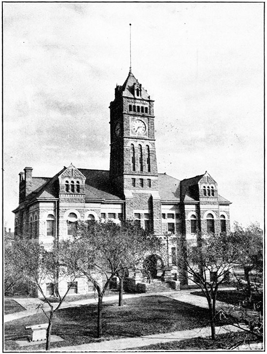
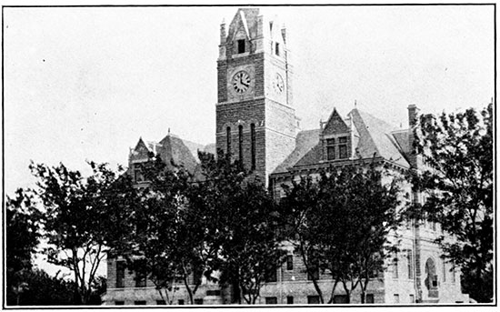
Plate XV--Osborne County courthouse, Osborne, constructed of Fort Hays limestone.
The so-called "shell rock," the uppermost limestone in the Jetmore member of the Greenhorn, is quarried rather extensively along the western border of Mitchell County. A quarry in the "shell" was noted on the north side of the west center of sec. 31, T. 9 S., R. 7 W., from which fence posts have been secured. Similar quarries were observed in the southeastern corner of the county. The "shell rock" in this locality is used entirely for fence posts, but farther east it has been used in buildings.
Hard beds occurring in the Fort Hays member of the Niobrara formation have been utilized for building stone in central and western Osborne County. The stone has a yellowish cream color and a pleasing appearance.
Coal
No coal has been mined in Mitchell County for a number of years, and none has ever been mined in Osborne County. A persistent seam of lignite occurs about 30 feet below the top of the Dakota formation, and its outcrop has been traced through Republic, Jewell, Cloud, Mitchell, Lincoln, Russell, and Ellsworth counties. It has not been consistently reported in wells drilled to the west of the outcrop, so it may disappear in that direction. The thickness ranges from 10 to 36 inches. The only possible areas in Mitchell County where it could outcrop or be sufficiently close to the surface to mine are in the Solomon valley below Beloit and in the Salt and Rock creek bottoms. If present in Osborne County its depth would be 100 to 350 feet below the surface.
The Dakota coal of western Kansas does not constitute an economic resource of any immediate importance. But at one time mines in this area were successfully operated. The fifth report of the state inspector of coal mines, for the year 1891, states concerning Mitchell County:
ANALYSIS. Kind of coal, lignite; average thickness of vein, 14 inches; total output, 1890, 23,700 bushels, or .03 per cent of the total output of the state; 1891, 26,000 bushels, or .03 per cent of the total output of the state; estimated value of output, 1890, $1,777; 1891, $1,950; number of employees, 1891, 20.
But little mining is done in this county, except during the winter months. The openings are all on the drift plan, and the work is performed largely by farmers and their families. The trade is entirely local. Saltville is the postoffice address of the men who run the drifts in this county.
Saltville post office, now abandoned, was located in the northeast corner of the southeast quarter of sec. 9, T. 9 S., R. 7 W. The mines were located on Salt and Rock creeks. One of these was reported to the writer as being located in the northwest corner of sec. 22, T. 9 S., R. 8 W. Mines have also been mentioned in the Solomon river valley (Crane, 1898, p. 143). The Blue Hill Mining Company is reported to have mined coal in the southeast quarter of sec. 32, T. 8 S., R. 9 W. (A. E. Jordan, informal communication). Inasmuch as this area lies in the outcrop of the Blue Hill shale it is believed that this coal must have come from a local carbonaceous phase.
Miscellaneous
Salt
Well records show that salt underlies all but the northern end of Osborne County, and the northern and eastern sides of Mitchell County. The salt occurs in the Permian strata and ranges in thickness from only a few feet to over 150 feet. The depth ranges from 800 feet at the Beeler well, in sec. 10, T. 9 S., R. 8 W., Mitchell County, to 1,625 feet in the Prater well, in sec. 30, T. 9 S., R. 15 W., Osborne County. Salt is obtained commercially from depths lying between 800 and 1,000 feet at several places in Kansas, the nearest plant being at Kanopolis, in Ellsworth county. Present market conditions do not justify the erection of another salt plant in Kansas, but the geological conditions are just as favorable for salt mining in southwestern Mitchell County (for instance at Hunter) as they are at Kanopolis.
Helium
Of considerable scientific interest is the presence of helium in gas obtained from a well drilled about 3 miles southwest of Victor, in Mitchell County, by W. H. Drinkern, of Beloit. The depth from which the gas is secured is 136 feet, which would place it in the Dakota formation. An analysis of the gas Iollows. [Government analyst. Data furnished by W. H. Drinkern.]
| Carbon dioxide | 18.72 |
| Oxygen | 0.31 |
| Methane | 0.95 |
| Nitrogen | 80.02 |
| Helium | 1.08 |
| Total | 101.08 |
Although the percentage of helium is unusually high, the total amount present cannot be very great, as the quantity of gas is small. The helium is probably derived from the disintegration of radioactive minerals contained in the Dakota sandstone.
Prev Page--Structural Geology || Next Page--References
Kansas Geological Survey, Geology
Comments to webadmin@kgs.ku.edu
The URL for this page is http://www.kgs.ku.edu/Publications/Bulletins/16/07_econ.html