![]()
Prev Page--Introduction || Next Page--Stratigraphy
Geography
Location and Culture
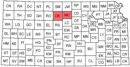
Mitchell and Osborne counties are located in northern Kansas in the second row of counties south of the Nebraska line and slightly west of center (Fig. 1). The former county contains five townships east and west and four north and south, with a total area of nearly 459,000 acres, while Osborne County is likewise five townships wide but has an added row of townships on its southern border, with a total area of approximately 573,000 acres. There are three cities in these two counties with a population greater than 1,000: Beloit, the county seat of Mitchell County, with a population slightly over 3,000; Osborne, the county seat of Osborne County, with a population a little less than 2,000; and Downs, in northeastern Osborne County, with a few hundred less than Osborne. There are a number of smaller towns, mainly in the Solomon river valley.
Figure 1--Index map of Kansas showing location of Osborne and Mitchell counties.
Three railroads serve this area. The Missouri Pacific enters Mitchell County near the northeast corner and follows the valley of the Solomon river from Beloit through Glen Elder and Cawker to Downs, where it divides, one branch going up the north fork of the Solomon through Portis, at the north boundary of Osborne County, to its terminus at Lenora, while the other branch cuts across to the south fork of the Solomon at Osborne and continues up that fork through Bloomington and Alton to its terminus at Stockton in Rooks County. A branch of the Union Pacific extends up the Solomon river valley from the main line at Solomon to Beloit. A branch of the Santa Fe extends from Salina in a northwesterly direction through Hunter and Tipton in southwestern Mitchell County and through east-central Osborne County to its terminus at Osborne.
U. S. Highway 40 North, in large part either paved or graveled, crosses the two counties in a general east-west direction following the course of Solomon river to Downs on the north fork and from there going west and south to Osborne and then out of the county along the valley of the south fork of the Solomon. State highways extend north and south through both county seats and, in addition, a state-maintained road connects Beloit with Concordia. Still another state highway crosses the southwestern corner of Osborne County, passing through the town of Natoma. Mitchell County maintains 167 miles of county roads and Osborne 78 miles. Section-line roads are present except where the topography is too rough.
Topography
Almost all of Mitchell and Osborne counties are drained by Solomon river and its tributaries. Salt and Rock creeks, which drain southern Mitchell County, enter Solomon river beyond the east border of the county. The southwestern corner of Mitchell County and the southern row of townships in Osborne County are drained by tributaries of Saline river, which flows eastward across Russell and Lincoln counties and eventually joins Smoky Hill river in Saline County a few miles west of the point where Solomon river also joins the Smoky Hill. Solomon river forks near the Mitchell-Osborne County line, the south branch coming from the west across Osborne County and the north fork flowing southeastward across the northeast corner of the same county. The valley of the Solomon has had a decided effect upon the culture of the two counties because of the fertility of its flood plain, its availability for water power, and the easy route it affords for railroads and highways. For these reasons the large centers of population are all located adjacent to the river. With the exception of the two major forks the tributaries of the Solomon are small; they have narrow valleys, and in few cases drain more than two townships.
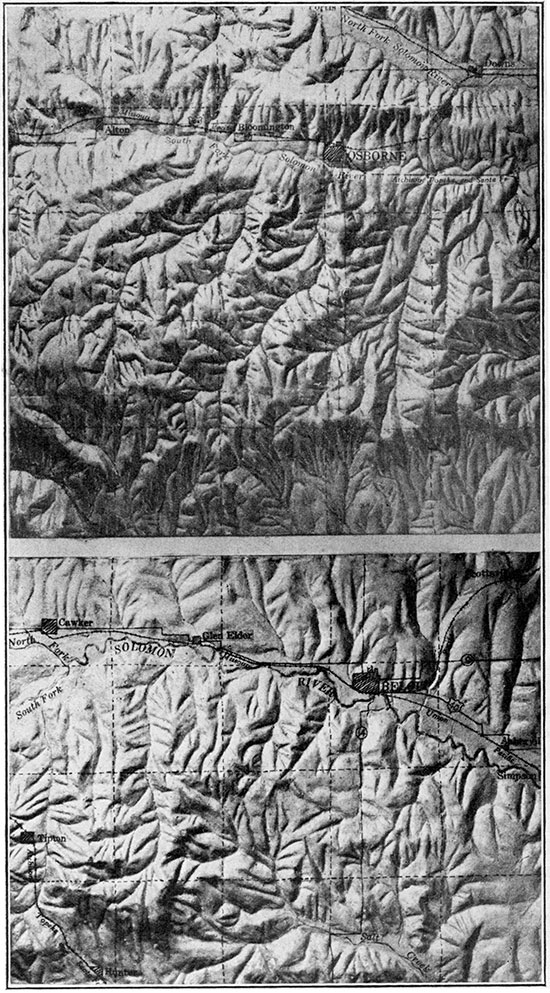
Plate 1--Upper: Relief model of Osborne County. Lower: Relief model of Mitchell County.
Elevations range between 1,300 feet in the Salt creek and Solomon valleys in the eastern part of the area to 2,100 feet on the top of divides in southwestern Osborne County. The Blue Hills in southwestern Mitchell County and similar hills in Osborne County stand considerably higher than the adjacent stream valleys. Relief ranging from 200 to 300 feet in a mile may be noted.
A succession of slopes and benches lies above river level. The lowest physiographic features are the flood plains, which were formed by the deposition of stream-carried material. The flood plain of Solomon river ranges in width from one to four miles and extends across Mitchell County and up both forks. The flood plains of the tributaries are very much narrower. Terraces, which are remnants of older and higher flood plains, may be observed at a number of places along the Solomon and in a few localities are very prominent. They were noted in Mitchell County between Beloit and Asherville and in the western part, where they stand about 12 feet above the present flood plain. Two terraces have been noted in the vicinity of Osborne, one about 7 feet above the present flood plain and the higher one 18 feet above. A terrace occurs between Alton and the western edge of Osborne County which has an average height of about 15 feet above the present flood plain. West of Downs on the north fork of the Solomon are three distinct benches, 2 feet, 5 feet, and 25 feet above the valley floor. Both the present flood plains and the terraces are composed of a silty loam which makes a very fertile soil and on which prosperous farms are located. The upper part of the Salt creek flood plain in southern Mitchell County contains a salt marsh, so conditions there are not favorable for cultivation, but farther down stream the flood plain is very successfully cultivated.
With the exception of a small thickness of Dakota sandstone and Graneros shale in the extreme eastern and southeastern parts of Mitchell County, the first formation encountered above flood-plain level in this county is the Greenhorn limestone. The Greenhorn is composed of alternating beds of hard limestone and shale, and its erosion produces a rocky slope. Consequently the outcrop area of this formation is not tillable except where the slope angle is a very low one, as in places north of the Solomon flood plain. A gentle slope permits deep soil formation. The top member of the Greenhorn is the "fence post" limestone, which is fairly resistant to erosion and which usually makes a shoulder between the valley slopes and the nearly flat upland. The plateau-like upland is a very prominent feature in central Mitchell County. A veneer of Fairport shale, measuring up to about 40 feet in thickness, covers the "fence post" limestone and is eroded to a rolling topography with very slight relief. Because of the limy character of the Fairport shale and the absence within it of any hard rocks it makes a good soil. The major wheat-producing area of Mitchell County is in Fairport shale. Unfortunately the rising surface to the west causes this shale to disappear under younger formations, so Osborne County does not have the agricultural advantage afforded by a "Fairport plateau." As the younger formations yield a less fertile soil, Osborne County produces on an average about a million dollars less wheat annually than does Mitchell County in spite of its greater area. Where the Fairport shale is very thin, as in southeastern Mitchell County, the soil is stony, due to the underlying limestones, and the land is used for grazing.
The Fairport shale forms the lower part of the Carlile formation. The upper part is the Blue Hill shale which is noncalcareous and more easily eroded than the Fairport. The Blue Hill shale is preserved only where a protective capping of Niobrara limestone is present. The generally steeper slopes in this shale and its low fertility due to lack of lime make it of little value for cultivation. A considerable part of the Blue Hill outcrop is given over to stock raising.
The Blue Hill shale is capped by Fort Hays limestone, the basal member of the Niobrara formation. This rock is very resistant to erosion and causes the formation of flat-topped buttes such as the Blue Hills and high plateaus. The upper member of the Niobrara, the Smoky Hill chalk, appears .in the higher parts of central and western Osborne County. It is generally eroded to form rocky slopes, but the presence of hard layers may cause the formation of buttes and small mesas. As a general rule the soil on the Fort Hays plateau and on the Smoky Hill chalk slopes and butte tops is very thin and stony. Large areas underlain by Niobrara rocks are unsuitable for cultivation and are used for grazing.
The Tertiary rocks which cover the Great Plains extend into western Osborne County. These remnants of the high plains form the uppermost bench in the area under discussion. The Tertiary rocks have been eroded to a rolling surface -which is successfully cultivated.
Prev Page--Introduction || Next Page--Stratigraphy
Kansas Geological Survey, Geology
Comments to webadmin@kgs.ku.edu
The URL for this page is http://www.kgs.ku.edu/Publications/Bulletins/16/03_geog.html