![]()
Prev Page--Wellington Formation || Next Page--Uses and Summary
Gypsum in the Easly Creek Shale
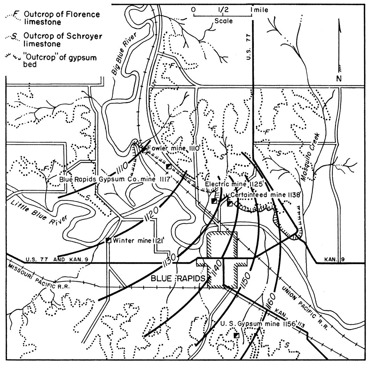
Mining of gypsum in the Easly Creek shale is limited to the area surrounding Blue Rapids, Kansas. The city is situated in the southwestern part of Marshall County, about a mile southeast of the junction of Big Blue and Little Blue Rivers, at an elevation of approximately 1,160 feet. The population in 1950 was 1,430. Blue Rapids is connected to Marysville, 11 miles to the north, by the Union Pacific Railway, and by U. S. Highway 77. The Missouri Pacific Railway and Kansas Highways 9 and 113 also provide transportation facilities in this area (Fig. 10).
Figure 10—Map showing geology, structure, and location of mines in vicinity of Blue Rapids. Structure contours are based on the gypsum bed.
Gypsum Production at Blue Rapids
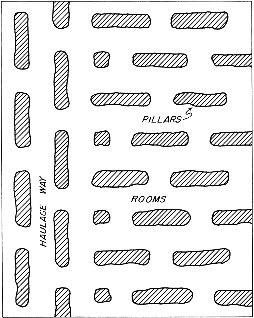
The only operating mine in the Blue Rapids area is the Certainteed Products Corporation Mine. The mine has recently (1954) been mechanized. Since mechanization the gypsum has been mined according to the system shown in Figure 11. Gypsum was formerly mined to the overlying shale bed, but since the mechanization a foot and a half of gypsum is left for a roof.
Figure 11—Diagram showing plan of mining used since mechanization in the Certainteed Products Company mine, Blue Rapids.
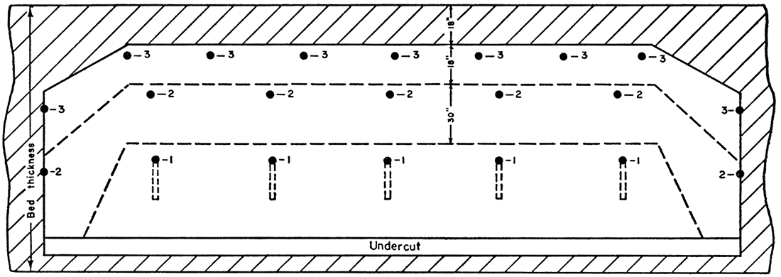
Except for the diesel locomotive, all equipment is electrically operated. The 20-foot rooms are undercut, drilled, and shot in the pattern shown in Figure 12. A mobile twin drill is used. The mine has two undercutting machines, which are carried on cat trucks.
Figure 12—Diagram showing placement of shot holes and undercut at Certainteed Products Company mine. Holes marked (1) are drilled at a downward angle; the rest are horizontal. Holes marked (1) are fired instantaneously and break the gypsum to the lower dotted line; (2) are fired at 50 millisecond delay and break to upper dotted line; (3) are fired with 100 millisecond delay and break to the roof.
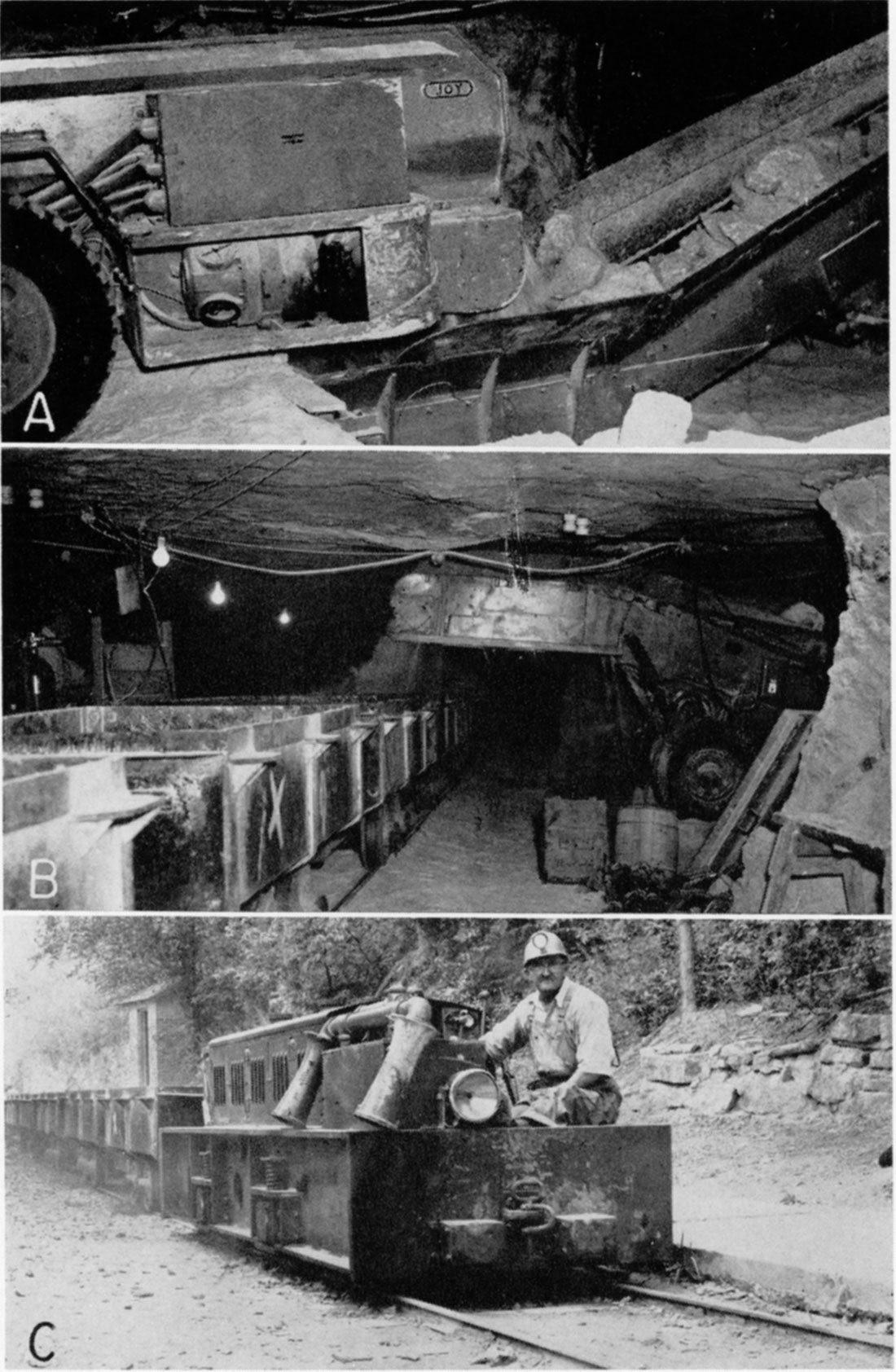
After the gypsum is shot it is loaded into shuttle cars of 10-ton capacity by a loading machine. They carry the gypsum to an elevating conveyor, which loads the trains (Pl. 16A, B). A car puller is used to move the trains at the loading point. A diesel locomotive is used to move the trains out of the mine (Pl. 16C). Each trip has 21 to 23 cars of 3-ton capacity each. The cars each weigh approximately 2,600 pounds empty. A battery locomotive is used to carry men in and out of the mine and as a standby for the diesel locomotive.
Plate 16—Equipment operating in Certainteed Products Company mine near Blue Rapids. A. Electrically operated shuttle car loading into loading machine. B. Loading machine loading mine train. C. Diesel locomotive pulling empty train outside mine.
The Certainteed Products plant is located directly outside the mine. Gypsum is crushed and calcined in kettles. By careful mining, by controlled calcining, and by the addition of certain selected ingredients, high-grade plaster products known to the trade as "specialty gypsums" are produced at the Blue Rapids plant. These products are dental plasters, orthopedic plasters, plate glass stuccos, casting plasters, molding plasters, gaging plasters, and statuary plasters. Gypsum is also sold for use in the manufacture of portland cement.
History
The presence of gypsum in Marshall County was first recorded in the Kansas Annual Register of 1864 (p. 196). Two years later, Mudge (1866, p. 26), described the deposits as being 4 to 10 feet thick.
The first scientific work was undertaken by Grimsley in 1897. He described the early history (Grimsley and Bailey, 1899, p. 51-52) as follows:
"The first gypsum deposits worked within the state of Kansas were in the northern or Blue Rapids area. In November, 1869, the commissioners laid out the site for the town of Blue Rapids. They carefully investigated the natural resources of the region and recognized the value of the gypsum deposits which had been known for some time to exist on the Big Blue, about two miles northwest of the town. On selling their various properties they made a reservation along the Blue of 100 rods, including the known outcrop of the beds and extending back from the river for a distance 320 feet.
"About the year 1871 Mr. J. V. Coon, of Elyria, Ohio, came to the new town, and, as the story goes, he burned some of the gypsum and carried it back to Cleveland, where it was pronounced to be of good quality, and two car-loads were ordered at a good price. He and a brother returned to Blue Rapids in 1872 and built a frame shed on the east bank of the river, below the town. In an iron kettle, which held about five barrels and which was heated by a stove, they commenced the manufacture of plaster of Paris. . . . in 1875 a stone mill was built by Coon & Son on the west side of the river, and the water power of the river was now used for grinding. The town, for purpose of encouragement of the new departure, granted them the north half of their reservation, described as extending from a point at the middle of the outcrop, and thence north. This mill was operated for nearly twelve years, and then the firm unfortunately failed. The mill property and the gypsum grant of fifty rods of outcrop and twenty rods back in the hill came into the hands of Mr. Sweetland, a business man of Blue Rapids. It was leased to several parties, and the mill was run to the year 1889, when the flood of that year caused considerable damage, resulting in the abandonment of the mill."
In 1899 three mills and mines were in operation near Blue Rapids. The largest and oldest of these was that of the Fowler Brothers. Gypsum was mined from the outcrop near the level of Blue River on the town's original grant, and the rock was shipped down the river on barges to a one-kettle mill just south and west of the dam at Blue Rapids. The gypsum was calcined into plaster of paris and shipped east in barrels. In 1912, the Fowler interests were sold to the U. S. Gypsum Company, and the mine was abandoned shortly thereafter.
The second operating mine described by Grimsley and Bailey (1899) was the Great Western Mine, which was opened in 1893 a mile north of Blue Rapids, approximately 50 feet above the valley of Blue River. In 1903, the property was sold to the American Cement Plaster Company. The Great Western Company was liquidated and later reorganized under a new name. As such, it opened the Electric mine on property adjoining the Great Western mine on the west. In 1912, this company again sold its interests to the American Cement Plaster Company. The two mines were subsequently acquired by the Beaver Products Corporation, which operated them until 1937, when the Certainteed Products Corporation assumed control.
In 1905, A. R. Dean of Blue Rapids dug a shaft into the bed of gypsum 1 1/2 miles northwest of the old Great Western mine. The Blue Rapids Gypsum Company was subsequently organized, and built a 3-kettle mill on a railroad spur to the Union Pacific Railway near by. After a few years of operation, the property was purchased by the American Cement Plaster Company, which soon abandoned the mine and dismantled the plant.
The third mine working in 1897 was the Winter mine, which was opened that same year two miles west of Blue Rapids at a point about 15 feet above Little Blue River. A dam was built across the river to provide water power, and a mill was erected adjoining the mine. Initial stripping operation was soon abandoned in favor of a double-entry underground mine. In 1912, the U. S. Gypsum Company, at the same time it purchased the Fowler interests, acquired the Winter mine. A few years later both plants were dismantled and moved to an area a mile south of Blue Rapids on property referred to by Grimsley as the "Yarrick farm". There a new plant was erected in a draw, and a double-entry mine was opened in a hill to the west. In 1929, the mine was closed and the plant was dismantled. Plans to open a new mine on the Lee property south of the Winter mine were abandoned, and the U. S. Gypsum Company ceased production in the Blue Rapids area.
Today, the Certainteed Products Corporation owns and operates the only working mine and mill in the Blue Rapids district, at the site of the old Great Western Company plant. It also holds leases on the Electric mine and the mine of the Blue Rapids Gypsum Company.
The locations of the various mines are shown in Figure 10.
Stratigraphy
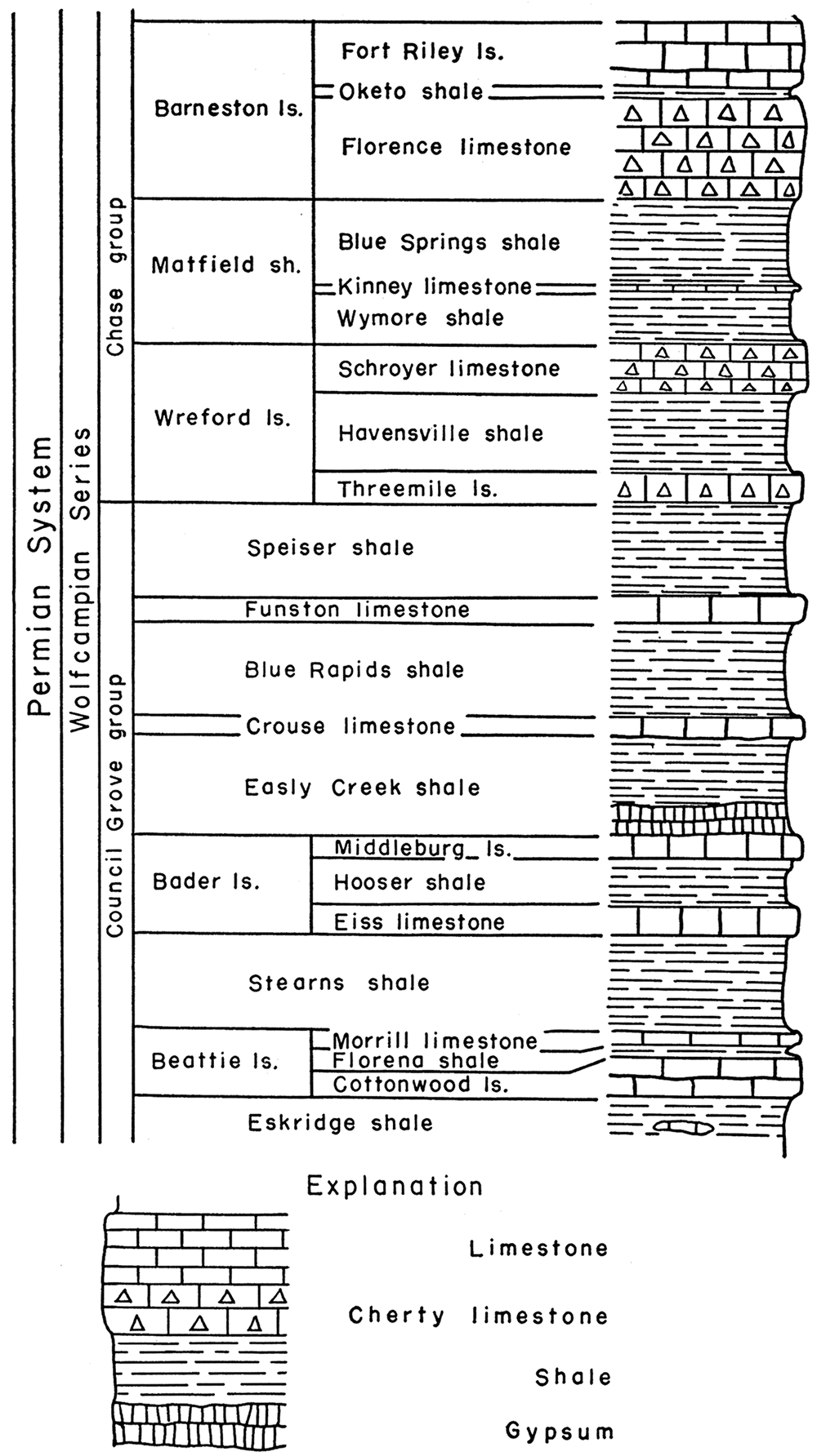
A generalized section of the rocks found in Marshall County is shown in Figure 13, modified from Walters (1954). Rocks exposed in the bluffs at Blue Rapids include formations from the Beattie limestone to the top of the Wreford limestone. The following description of this sequence is taken from Walters (1954).
Figure 13—Stratigraphic section of some lower Permian rocks exposed in the vicinity of Blue Rapids. Modified from Walters (1954).
Eskridge Shale
"Green and gray shale is the predominant material in the upper part of the Eskridge shale. The lower half of the formation is composed chiefly of red and maroon shale. Impure limestone beds less than 1 foot thick occur in all parts of the formation but are most numerous in the upper half. Limestone beds in the upper part of the formation are commonly fossiliferous. The thickness of the Eskridge shale ranges from 24 to 28 feet.
Beattie Limestone
" . . . The members of the Beattie limestone are, in ascending order: the Cottonwood limestone member, the Florena shale member, and the Morrill limestone member.
"The lower 1 to 2 feet of the Cottonwood limestone member consists of soft, fossiliferous, light-gray limestone that weathers rather slabby. The remaining 5 to 6 feet of the member is very massive, hard, gray limestone containing an abundance of fusulinids and scattered chert nodules. The Cottonwood limestone member forms a very conspicuous bench that is usually accentuated by a heavy growth of vegetation. . . .
"The Florena shale member consists of 2 to 3.5 feet of tan to dark-gray, calcareous shale. Fossils are very numerous in the Florena shale; locally thin shell beds within the member are composed almost entirely of Chonetes, Dictyclostus, [sic] and Composita.
"The Morrill limestone member ranges in thickness from 3.5 to 7.5 feet. The member is made up chiefly of massive, soft, light-gray limestone. Fossils of brachiopods, echinoids, and crinoids are common in the lower part. The Morrill limestone member is less resistant to weathering than the Cottonwood limestone member, and is not generally well exposed in Marshall County.
Stearns Shale
"Dark-gray, calcareous shale is the predominant material of the Stearns shale, but red and green shale is present in the upper part. Thin, impure limestone beds occurring near the middle of the formation contain brachiopods and pelecypods. The thickness of the formation in Marshall County ranges from 17 to 20 feet.
Bader Limestone
"The Bader limestone is divided into three members, which in ascending order are: the Eiss limestone member, the Hooser shale member, and the Middleburg limestone member. The thickness of the formation in Marshall County ranges from 17 to 22 feet.
"At the base of the Eiss limestone member is a massive, argillaceous, light-gray limestone about 2.5 feet thick. This bed is nonresistent to weathering and is well exposed in few places. The middle part of the member is composed of fossiliferous gray shale generally about 2.5 feet thick. The upper part of the Eiss limestone member is composed of a very massive limestone about 4 feet thick. In weathered outcrops this upper bed is commonly pitted and has solution channels. A very conspicuous bench is formed by the upper part of the Eiss limestone member.
"The Hooser shale member consists of 8 to 11 feet of sparsely fossiliferous shale. A large part of the shale is green and gray, but bands of pink and maroon are common near the center of the member.
"At the base of the Middleburg limestone member is a limestone bed about 2 feet thick, dark gray at the top and yellowish brown below, and containing many fossils. About 1 foot of dark-gray calcareous shale separates the lower limestone bed and an upper limestone bed just about a foot thick. The upper bed of the Middleburg limestone member is fossiliferous and weathers pitted. The Middleburg limestone member does not form a conspicuous bench.
Easly Creek Shale
"A massive bed of gypsum 8 to 9 feet thick occurs at the base of the Easly Creek shale in the area around Blue Rapids. This gypsum bed is readily leached away when exposed to weathering and is not generally present in natural outcrops, but it is exposed in mine workings and has been penetrated in many wells in the area. The gypsum is overlain by about 10 feet of gray, green and red shale.
Crouse Limestone
"The Crouse limestone, typically a platy, thin-bedded, argillaceous, gray limestone, has a bed of gray calcareous shale about 2.5 feet thick near the middle of the formation. The upper limestone bed is more massive and crystalline than the lower bed. Fossil fragments are common, but well-preserved specimens are rare. The total thickness of the formation is about 7.5 feet.
Blue Rapids Shale
"The Blue Rapids shale consists principally of blocky gray shale, but contains a few feet of black shale at the top and some green and red shale in the lower part. Thin impure limestone beds are present in some exposures.
Funston Limestone
"The Funston limestone is not generally well exposed in Marshall County, and the thickness and lithology of the formation vary considerably from exposure to exposure. In general, the Funston limestone consists of two limestone beds with a bed of shale between. The lower limestone is generally massive, argillaceous and weathers pitted. The limestone bed is usually slightly less than 3 feet thick. The lower limestone bed is overlain by about 2 feet of gray, gray-green, and red shale. The upper limestone bed is about a foot thick, somewhat argillaceous, and massive to platy.
Speiser Shale
"The lower part of the Speiser shale in Marshall County consists of about 15 feet of varicolored shale. Only the upper 2 or 3 feet of this part of the Speiser shale is calcareous. The second unit of the formation is a very persistent limestone bed about a foot thick. This limestone is hard, gray, and massive and contains fragments of fossils. The upper unit of the Speiser shale consists of about 3 feet of dark-gray to black calcareous fossiliferous shale.Wreford Limestone
"The Wreford limestone, which includes two limestone members and a shale member, has an average thickness of about 35 feet in Marshall County. The Wreford limestone is the oldest exposed formation in Marshall County which contains an abundance of chert.
"The Three Mile limestone member, which overlies the Speiser shale, consists of about 7 feet of hard gray limestone in massive beds about a foot thick. The chert occurs in bands or as scattered nodules. . . . The limestone beds near the middle of the member contain less chert than the upper and lower beds. Brachiopods are the most common fossils in the Three Mile limestone member.
"The Havensville shale member ranges from 14 to 20 feet in thickness in Marshall County. The member is typically a gray to gray-green blocky calcareous shale, but locally it is composed almost entirely of soft thin-bedded gray limestone. Small quartz geodes are generally imbedded in the upper few inches of the member.
"The thickness of the Schroyer limestone member ranges from about 10 to 13 feet. The lower 4 or 5 feet of the member is hard, gray, fossiliferous limestone containing only a few thin bands of chert. About 2 feet of buff to brown fossiliferous shale generally separates the relatively noncherty lower beds of limestone from the more cherty upper beds. . . . The upper 4 to 6 feet of the member consists of beds of tan to buff, hard, fossiliferous limestone containing an abundance of chert.
Matfield Shale
"The Matfield shale is divided into three members, which are in ascending order: the Wymore shale member, Kinney limestone member, and the Blue Springs shale member. The average thickness of the formation in Marshall County is about 57 feet.
"The Wymore shale member consists of 20 to 23 feet of gray, gray-green, and red-brown shale. Thin discontinuous limestone beds are locally present in the lower part.
"The Kinney limestone member consists of 2 to 5 feet of massive to platy gray and yellow limestone. The lower part of this member contains many brachiopods and mollusks.
"The Blue Springs shale member consists of about 34 feet of silty varicolored shale. The lower part of the member is generally non-calcareous and contains many gypsum nodules and seams.
Barneston Limestone
"The Barneston limestone, the thickest limestone formation in Marshall County, contains the most massive beds of any formation in the county. The average total thickness of the formation is about 50 feet. It crops out in the bluffs along Big and Little Blue Rivers throughout their courses in the county. The members of the Barneston limestone, in ascending order are: the Florence limestone member, the Oketo shale member, and the Fort Riley limestone member.
"The Florence limestone member is easily recognized because of the abundance of chert or flint imbedded in the limestone. In fact, this member is often referred to as the Florence flint. The member is actually a series of beds of limestone and beds of chert. The noncherty beds are generally only slightly thicker than the cherty beds. Many fossils are present in all parts of the Florence limestone member. A rather persistent shale break about 2 feet thick is present in the upper few feet of the member. The Florence is not resistant to weathering and is dissected into steep-sided, rounded hills. The thickness of the member ranges from 22 to 28 feet.
"The Oketo shale member, which was named from exposures at Oketo in Marshall County, ranges in thickness from a few inches to more than 6 feet. At most exposures in the county the member consists of hard, gray, calcareous shale containing many brachiopods, crinoids, and echinoid remains.
"A hard, gray, very massive bed of limestone about 6 feet thick occurs at or near the base of the Fort Riley limestone member in Marshall County. This is the limestone bed that forms the 'rim rock' or natural rock wall type of outcrop seen near the top of many hills bordering the valleys of Big Blue and Little Blue Rivers. The massive 'rim rock' bed is sometimes underlain by as much as 5 feet of impure, thin-bedded limestone and thin beds of shale. The middle part of the member is composed of alternating thin beds of limestone and shale, the shale beds generally being somewhat thicker than the limestone beds. Beds near the top are generally massive, but are soft and much less resistant than the massive beds in the lower part of the member. Weathered exposures of the upper part of the Fort Riley may have a pitted and cavernous appearance. Massive beds of this limestone have been extensively quarried for use as building stone and road material in Marshall County. The average thickness of the member is about 25 feet".
Figure 10 shows the gypsum outcrop and outcrops of the base of the Florence limestone and the base of the Schroyer limestone in the Blue Rapids area, in part from Walters (1954). The base of the gypsum or its stratigraphic equivalent can be traced from a point where it dips below the alluvium at an elevation of 1,121 feet in the SE sec. 17, T. 4 S., R. 7 E., past the Electric mine (1,125 feet), across old Highway 77 (1,132 feet), past the Certainteed mine entrance (1,139 feet), past the area known as the "Narrows" (1,152 feet), and along the side of the bluff until it passes beneath the alluvium on the west bank of Mosquito Creek in sec. 22, T. 4 S., R. 7 E.
Structural Geology
General Structure
The sedimentary rocks of the Blue Rapids area lie on the western slope of a gentle arch over the buried Nemaha anticline. A few small flexures and minor distortions disturb the general westward dip of the strata.
Similar small structural features are present in Riley County, the northern boundary of which lies 8 miles south of Blue Rapids. Jewett (1941, p. 99-100) has ascribed these structures to differential compaction on the uneven surfaces of the crystalline rocks of the Nemaha anticline. Wells drilled in T. 2 S., R. 9 E., in Marshall County, show the crystalline basement to lie at depths ranging from 1,200 to 1,400 feet.
Local Structure
The elevations of the various mines and, where possible, of the base of the gypsum, were determined in the field by plane table and alidade. From these elevations, from core-drill data, and from known elevations within the Certainteed mine, a structure contour map (Fig. 10) on the base of the gypsum was drawn. From this map it is evident that the dip and strike of the gypsum vary slightly. In the vicinity of the U. S. Gypsum mine, the gypsum strikes northeast, and dips about 13 feet per mile northwest. In the vicinity of the Certainteed mine, however, it strikes north to northwest, and dips 30 to 45 feet per mile west to southwest. At the Fowler mine, it again strikes northeast, and dips about 20 feet per mile northwest.
Occurrences of Gypsum
The gypsum that is mined in the Blue Rapids district is a massive bed averaging 8 or 9 feet in thickness. A layer of satin spar about half an inch thick normally lies along the upper contact and in many places a quarter-inch layer lies along the lower contact. Layers of satin spar also occur in the overlying Easly Creek shale at some places.
The gypsum bed is composed essentially of massive or rock gypsum, ranging from white to gray, tinted somewhat pink. In texture it ranges from saccharoidal to platy, but most of it is granular. Specimens fracture irregularly. Shale is the only impurity visible megascopically.
The gypsum bed has no definite topographic expression. It is naturally exposed only along the banks of Blue River, where the rate of erosion seemingly exceeds the rate of solution of the gypsum.
Certainteed Mine
The plant of the Certainteed Products Corporation (Frontispiece) is situated on the floor of the Blue River valley in T. 4 S., R. 7 E., at an elevation of about 1,115 feet. A northwestward-trending bluff north of the plant averages 140 feet in height. The mine entrance is situated on the face of this bluff at an elevation of 1,140 feet.
Studies within the Certain teed Mine showed that the gypsum has the following general characteristics: ( 1) The gypsum pinches out fairly abruptly near the outcrop. The overlying shale slumps down and, with some residual material, takes the place of the gypsum. These relations can be observed at the south end of a drift 400 feet east of the main entry, where the gypsum pinches out approximately 100 feet from the outcrop. (2) Solution channels are present in the gypsum near the outcrop. This may be observed in the old workings adjacent to the main entry. (3) The lower surface of the gypsum is relatively uniform, except for a few small reversals of dip. (4) The upper surface of the gypsum is very irregular. (5) Generally, in areas where there are depressions in the upper surface of the gypsum, (a) the amount of shale in the upper portion of the gypsum is noticeably greater, (b) the satin spar along the upper contact is more fully developed, (c) satin spar is more abundant in the overlying shale, and (d) pink gypsum is present locally near the upper contact.
Other Occurrences of Gypsum
A reconnaissance of the other gypsum localities in the Blue Rapids area was made. The general characteristics of the gypsum bed were found to be relatively uniform throughout the region, although some minor variations were noted.
U. S. Gypsum mine—The entrances to the workings of the U. S. Gypsum mine are so badly caved that the mine is inaccessible, but the Easly Creek shale is well exposed along the west side of the creek about 200 feet south of the mine entry. Weathered specimens of gypsum were found in this area.
Blue Rapids Gypsum Company mine—The Blue Rapids Gypsum Company mine is also inaccessible. According to the original owner, A. R. Dean (personal communication) the gypsum averages 8 or 9 feet in thickness and satin spar lies along both contacts. The site of the old mill is still visible.
Fowler mine—The entrance to the Fowler mine is blocked by fallen shale and alluvium, but the gypsum crops out in the bed of Big Blue River about 300 feet north of the mine entry. Along the east bank of the river there is a marked flexure in the Easly Creek shale, which overlies the gypsum. The flexure probably was caused by collapse of the gypsum due to solution by the waters of the river. The Crouse limestone, which is more competent than the shale, is undisturbed above the flexure.
Hand specimens from the outcrop have saccharoidal texture and show effects of solution. According to Grimsley and Bailey (1899, p. 53), the gypsum within the mine contained veins of transparent selenite in crystals several inches long.
Winter mine—Remnants of the old Winter mill and of a dam across Little Blue River still exist. The mine entrance lies about 300 feet south of the dam, and about 15 feet above the level of the river. Fallen roof now blocks the entrance, but access to several hundred feet of the workings was possible at the time field studies were made. The gypsum averages 8~ feet in thickness, and a quarter to half inch of satin spar lies along the upper contact. Pink, saccharoidal gypsum occurs about 15 feet within the mine. The full extent of slumping caused by collapse of the mine roof can be seen in fields southeast of the mine. The most distant of these is approximately 2,000 feet from the mine entrance.
Electric mine—Entrance to the Electric mine from the surface is impossible, but the underground workings of the Certainteed mine have joined those of the Electric mine. Samples obtained underground were similar megascopically to gypsum from the Certainteed mine. Most of the Electric workings are now under water.
Other localities—Near Waterville, along Little Blue River, pink nodules of gypsum occur locally in shale members of the Crouse limestone. On the farm of Fred Stocks, about a mile south of the Winter mine, a shaft dug about 1900 revealed a bed of gypsum 9 feet thick at a depth of 30 feet. Numerous water wells on farms in the area have encountered gypsum at various depths.
Petrology of the Gypsum of the Blue Rapids Area
Observations
Megascopically, the gypsum bed is composed principally of white to gray massive gypsum. Satin spar and selenite are present locally. A small amount of shale is interbedded with the gypsum.
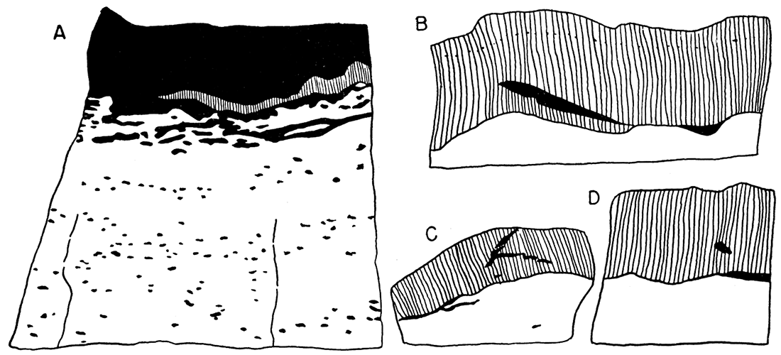
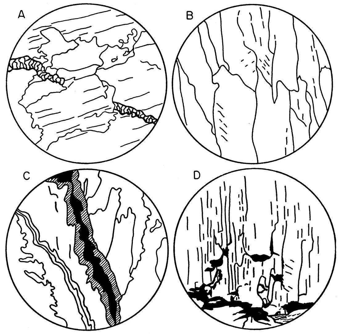
No anhydrite is present. Brown, argillaceous limestone lies beneath the gypsum. A diagram of a portion of the lower contact (Fig. 14a) shows the characteristic gradation of limestone into gypsum. Grayish-green shale overlies the gypsum. Layers of satin spar lie along the upper and lower contacts. The satin spar layers are composed of slightly curved, white prismatic crystals. The layer along the upper contact increases in thickness where there are depressions in the upper surface of the gypsum. Shale separates the upper layer of satin spar from the gypsum in most places, and is present locally within the satin spar (Fig. 14b, c, d).
Figure 14—Sketches showing relation of gypsum to other rocks in the Easly Creek shale. (All are X 0.7 [adjusted for web presentation]). A. Gradation of underlying limestone (light) into gypsum (dark). Note layer of satin spar. B. Satin spar interfingered with shale (dark) along upper contact of gypsum (light). C. Satin spar interfingered with shale (dark) from overlying formation, along upper contact of gypsum (light). D. Satin spar containing inclusion of shale (dark) along upper contact of gypsum (light).
Microscopically, the gypsum bed is composed principally of small anhedral crystals of gypsum, ranging in diameter from 0.01 to 2.0 mm. Buff to gray shale and grains of calcite are present along some crystal boundaries. Selenite crystals having a maximum dimension of about 5 mm are relatively common in the upper and lower parts of the bed. The selenite exhibits undulatory extinction. Veinlets containing satin spar or finer-grained gypsum also are present locally in the upper and lower parts of the bed.
To facilitate field sampling, the gypsum bed was arbitrarily subdivided into three equal parts—lower, middle, and upper—which terms will be used in the following discussion.
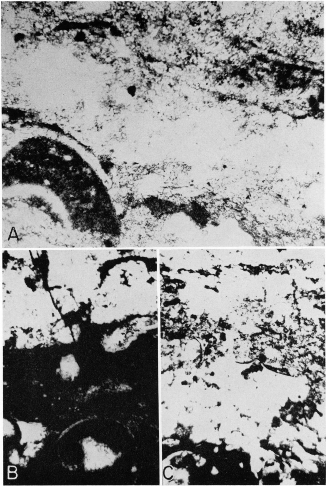
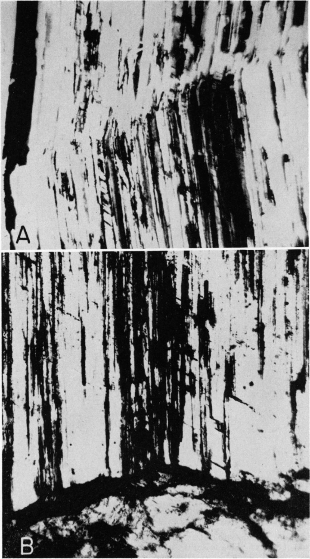
Lower part of the gypsum bed—The limestone that lies beneath the gypsum is brown and fossiliferous. The gradational zone between limestone and gypsum contains many well-developed crystals of gypsum, which have uniform birefringence and sharp extinction. Calcite stringers are included locally within individual gypsum crystals. These stringers contain some marine microfossils, such as gastropods.. ostracodes, foraminifera, and some pelecypods (Pl. 17).
Plate 17—Photomicrographs of gradational contact of underlying limestone with gypsum in Easly Creek Shale. A. Gradational zone between limestone (dark) and gypsum (light). Gastropod in lower left of field is cut approximately normal to its axis of coiling. Note probable replacement by gypsum of portions of gastropod. (Crossed nicols, X 130 [adjusted for web]). B. Lower portion of "C" enlarged. Gastropod in lower center of field is cut approximately parallel to its axis of coiling. (Plane light, X 130 [adjusted for web]). C. Gradation of underlying limestone (dark) into gypsum (light). (Plane light, X 32 [adjusted for web]).
The layer of satin spar along the lower contact is thin and discontinuous. Its position in relation to the gradational zone is variable. Individual crystals are oriented, in most places, with their C axis normal to the walls. In many places crystals from opposite walls interfinger near the center of the layer.
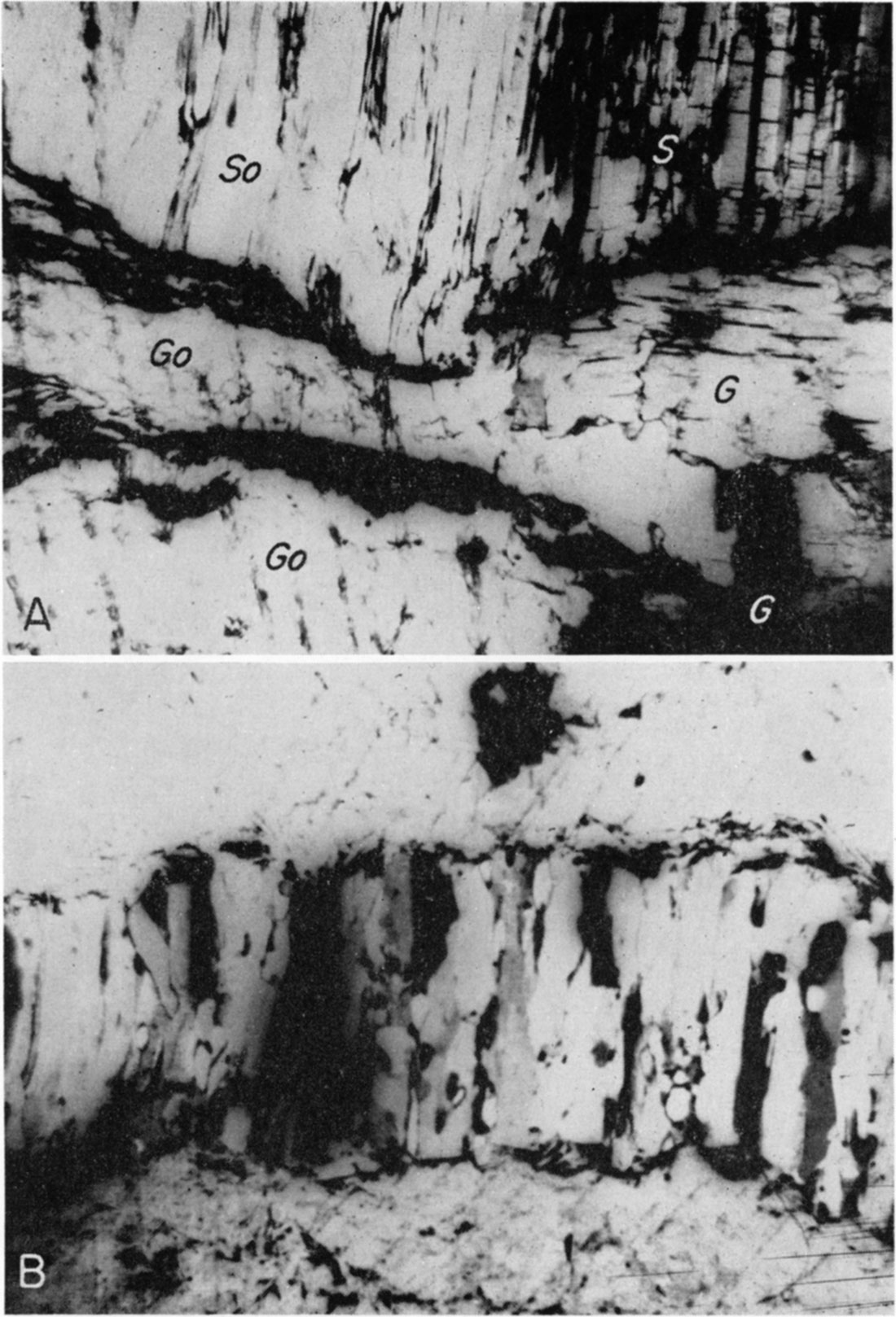
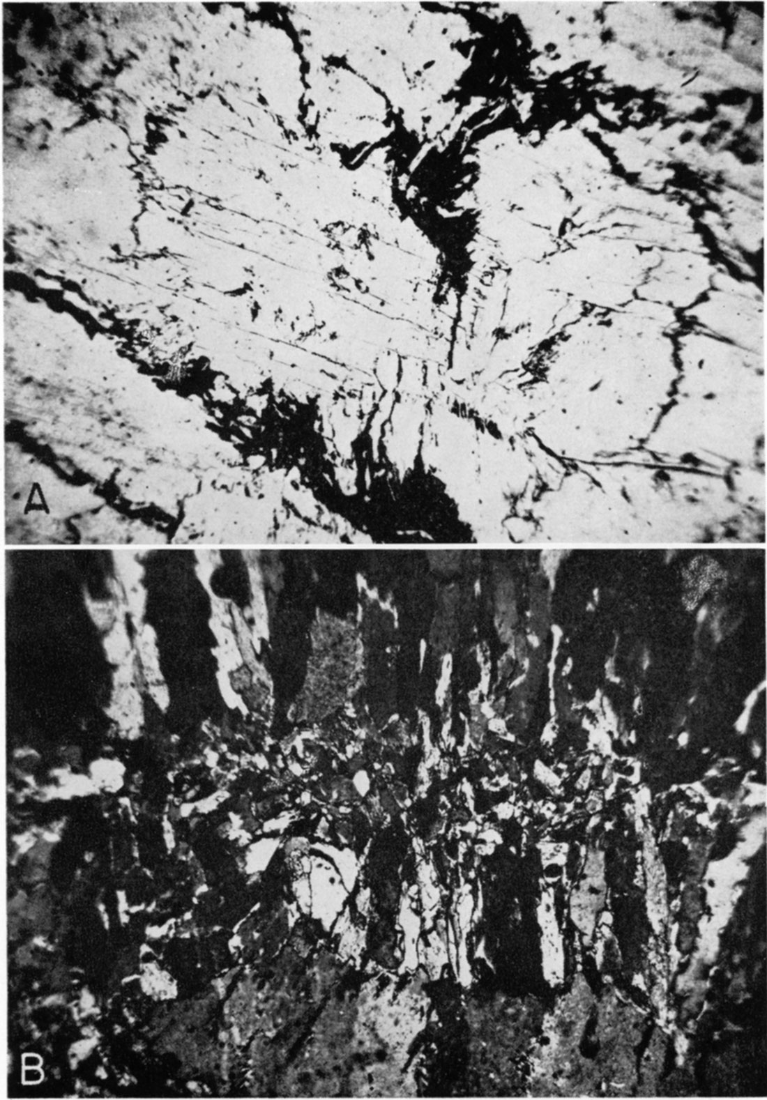
Plate 18—Photomicrographs showing relation of satin spar to selenite. A. Relations near upper contact, showing optical continuity between satin spar (So) and selenite (Go), but not between satin spar (S) and selenite ( G). Selenite maintains optical continuity around shale (dark). (Crossed nicols, X 29 [adjusted for web]). B. Veinlet of satin spar, near lower contact, with sharp, matching walls of selenite. Shale (dark) lies along borders of veinlet. Optical continuity locally between crystals in vein let and in wall. (Crossed nicols, X 29 [adjusted for web]).
The lower portion of the bed contains many crystals of selenite, particularly near the lower contact, and scattered masses of calcite. There are numerous small veinlets of satin spar and finer-grained gypsum. Figure 15a illustrates a veinlet of fine-grained gypsum with comparatively sharp walls, interrupted by a crystal of selenite. Plate 18B illustrates a veinlet of satin spar, with sharp, parallel, matching walls of selenite. Shale selvage lies along both walls of the veinlet. Crystals composing the veinlet are oriented with C axis normal to the walls. Few crystals maintain continuity from wall to wall, Locally, optical continuity exists between crystals in the veinlet and portions of the wall. Many crystal boundaries are obscure. Other vein lets of finer-grained gypsum with less definite walls also are present in the lower part of the bed. Shale lies parallel to the walls of many veinlets. Farther from the lower contact, the lower part of the gypsum is composed principally of small, equigranular crystals of gypsum, showing random orientation. Selenite crystals are few and scattered.
Figure 15—Camera lucida drawings showing details of gypsum rock in gypsum bed in Easly Creek shale. A. Veinlet of fine-grained gypsum, interrupted by crystal of selenite. Near lower contact. (Crossed nicols, X 16 [adjusted for web]). B. Interior of veinlet of satin spar, showing interfingering crystals. Near lower contact. (Crossed nicols, X 32 [adjusted for web]). C. Crustified gypsum (shaded) along the walls of an open fracture. Unfilled portions of fracture are black. Near upper contact. (Crossed nicols, X 16 [adjusted for web]). D. Upper layer of satin spar (light), separated from underlying gypsum by shale (dark). Note the occurrence of shale at the end of some individual crystals of satin spar. (Crossed nicols, X 32 [adjusted for web]).
Middle part of the gypsum bed—The middle part of the bed is composed chiefly of small, equigranular crystals of gypsum, showing random orientation. Shale and some calcite lie along the borders of many crystals. Less calcite is present, however, than in the lower part of the bed. There are only a few scattered crystals of selenite.
Upper part of the gypsum bed—The upper part of the bed, away from the upper contact, resembles the middle. Very little calcite is present. Near the upper contact the gypsum is composed chiefly of selenite crystals, locally interfingering with grayish-green shale that resembles the overlying shale (Pl. 20A). There are many small veinlets of satin spar and finer-grained gypsum near the upper contact. Figure 15b illustrates a noticeable zone of interfingering crystals in a veinlet of satin spar. In some veinlets, however, satin spar crystals are continuous and are orientated normal only to one wall. Figure 15c illustrates crustified gypsum along the walls of an open fracture near the upper contact.
The layer of satin spar along the upper contact is continuous and well developed locally. Crystals are orientated parallel to one another (Pl. 19B) and normal to the stratification of the overlying shale, rather than to the upper surface of the gypsum. Most crystals have sharp boundaries and are continuous. Plate 18A illustrates a portion of the bed near the upper contact; optical continuity is maintained between part of the satin spar above the contact and the selenite below. The optical continuity of the selenite is not disturbed by the presence of interfingering shale. Those crystals of satin spar that maintain optical continuity with selenite have indistinct boundaries and exhibit undulatory extinction. Shale, present locally in the satin spar, lies at the end of individual crystals, as illustrated in Figure 15d. Fractures in the satin spar are relatively few and discontinuous. Curvature of satin spar crystals is independent of fracture (Pl. 19A), some crystals maintaining their optical continuity past the line of curvature. The direction and amount of curvature differ in different parts of the satin spar layer. Some satin spar crystals in the overlying shale are curved in a similar manner.
Plate 19—Photomicrographs of satin spar. A. Curvature in satin spar, near upper contact of gypsum. Note that some crystal maintain optical continuity past line of curvature. (Crossed nicols, X 42 [adjusted for web]). B. Upper layer of satin spar, separated from underlying gypsum by thin shale larer (dark). Note that satin spar crystals are not oriented norma to upper surface of gypsum (Crossed nicols, X 35 [adjusted for web]).
Petrologic Interpretations
Original deposition of the gypsum—The gradational zone between the underlying limestone and the gypsum indicates a gradual approach to sulfate saturation of the sea. Inasmuch as large crystals of gypsum showing uniform birefringence and sharp extinction lie along the lower contact, initial precipitation probably was slow, crystallization being concentrated at relatively few points. Calcite, which was still precipitating, accumulated in stringers, which were incorporated within the slowly growing gypsum crystals. As the sulfate concentration increased, precipitation of gypsum was accelerated, crystallization occurring simultaneously at many places. The mutual interference of crystals (Lindgren, 1933, p. 24) may have been sufficient to prevent the growth of large crystals; thus, most of the bed probably was deposited originally as small, equigranular crystals of gypsum, with random orientation. Calcite and shale, which were deposited at the same time, accumulated along the borders of some of the rapidly precipitating gypsum crystals. The absence of large crystals of gypsum near the upper contact of the bed suggests that precipitation of gypsum may have ceased abruptly.
Evidence of recrystallization—The microscopic characteristics of some selenite crystals suggest their formation by recrystallization. The characteristics that suggest formation of selenite crystals in the bed by recrystallization are: (1) obscurity of boundaries of some adjacent selenite crystals; (2) interfingering of shale and selenite, optical continuity of some selenite being maintained around the shale; (3) optical continuity between satin spar crystals in a veinlet and the selenite of the vein walls; (4) optical continuity between the satin spar layer along the upper contact and crystals of selenite below the contact; and (5) inclusion of small gypsum crystals within the boundaries of some selenite crystals. Some of these characteristics indicate secondary deposition. Solution, insofar as it has effected enlargement of pre-existing crystals, is regarded as a phase of recrystallization, but insofar as it has effected the removal of part of the gypsum, it will be considered later as a separate process.
Microscopically, the selenite crystals exhibit undulatory extinction, a characteristic that has been observed in selenite from other localities. Undulatory extinction in quartz crystals from low temperature veins has been described by Adams (1920, p. 653), who attributes the phenomenon to slight differences in orientation caused by the coalescence of small crystals to produce large ones, and not by internal strains. Application of Adams' data indicates that the undulatory extinction of selenite may be evidence of recrystallization. Photomicrographs of crustified quartz (Adams, 1920, p. 623-664) show features bearing a close resemblance to those of parts of the gypsum bed that may have undergone recrystallization.
Evidence relative to recrystallization during diagenesis—Some selenite may have been formed by recrystallization effected by sea waters during diagenesis-that is, before complete lithification of the gypsum. The presence of scattered selenite crystals away from the contacts lends credence to this possibility. It is improbable that ground water penetrated this area, as no open fractures or veinlets are present. The characteristics of other chemical precipitates, particularly limestones (Grabau, 1932, p. 755-756), have been explained as the result of recrystallization during diagenesis.
Evidence relative to recrystallization by ground water—Most of the selenite in the gypsum bed probably was formed by recrystallization effected by ground water. Recrystallization subsequent to lithification is indicated in two ways. In some specimens of selenite that interfinger with shale near the upper contact there is optical continuity of selenite around the shale, which indicates recrystallization after introduction of the shale. In specimens from the upper part of the bed near the upper contact (Pl. 18A) optical continuity exists between part of the satin spar and the adjacent selenite. The origin of the satin spar and its relation to the gypsum will be considered in detail later.
The action of ground water in effecting recrystallization is indicated also by field observations. Most of the selenite occurs in the parts of the gypsum bed most susceptible to ground-water penetration—that is, near the upper and lower contacts and adjacent to fractures in the gypsum. Only a few crystals of selenite are scattered elsewhere in the gypsum bed. The vertical extent of selenite near the upper contact of the gypsum is greater than near the lower contact, suggesting that the recrystallizing waters moved mainly downward, and thus probably were meteoric.
Evidence relative to secondary solution and redeposition—The effect of secondary, or meteoric, solution on the gypsum bed is indicated in the field by: (1) the absence of outcrops of gypsum, except where the rate of erosion seemingly exceeds the rate of ground-water solution, as along Blue River; (2) pinching out of gypsum in the Certainteed mine as the outcrop is approached; (3) the presence of water channels in gypsum near the outcrop in the Certainteed mine; and (4) the collapse of overlying shale due to solution of gypsum by Big Blue River north of the Fowler mine.
Redeposition of gypsum is indicated by the numerous veinlets of satin spar in the gypsum bed and in the overlying shale. The probable sequence of events to produce a veinlet of satin spar with indefinite walls (Pl. 20B) is: initial deposition of gypsum, lithification, fracture, deposition of satin spar along the fracture, solution to form irregular walls, and solution and redeposition to form a small irregular veinlet of finer-grained gypsum. Several steps may have been contemporaneous. In a veinlet of fine-grained gypsum having roughly parallel, matching walls (Fig. 15a), the sequence may have been: initial deposition of gypsum, lithification, fracture, deposition of fine-grained gypsum along the fracture, solution to form slightly irregular walls, and recrystallization to form selenite, a crystal of which interrupts the veinlet. Recrystallization may have occurred during lithification; if so, two periods of recrystallization are indicated. Some events may have been contemporaneous. For crustified gypsum along an open fracture (Fig. 15c) the sequence of events may have been: initial deposition of gypsum, lithification, fracture, recrystallization of the walls, solution, and redeposition along the open fracture. Recrystallization may have taken place during lithification.
Plate 20—Photomicrographs of gypsum. A. Selenite (light) interfingering with shale (dark). (Plane light, X 64 [adjusted for web]). B. Upper portion of gypsum with elongate crystals resembling satin spar. Note small veinlet of fine-grained gypsum trending left to right. (Crossed nicols, X 31 [adjusted for web]).
Circulating ground water may have introduced mechanically a part of the shale that fills fractures near the upper contact, inasmuch as such shale is identical to that which overlies the gypsum. The shale along veinlets and fractures elsewhere in the gypsum, however, resembles that which lies along the borders of the smaller crystals of gypsum. Residual accumulation of clay may have resulted from ground-water solution of gypsum. The amount of shale present in some veinlets does not exceed the calculated amount contained in the gypsum prior to solution. The sequence of events that may have produced a veinlet of satin spar with shale along both walls (Pl. 18B) is: initial deposition of gypsum, lithification, recrystallization to form selenite, fracture, introduction of shale along the fracture, further fracture along the same plane, deposition of satin spar, and further recrystallization. The first period of recrystallization may have occurred during lithification or after introduction of shale. The second period of recrystallization is indicated by the obscurity of boundaries of adjacent satin spar crystals, and by the local optical continuity between satin spar and the walls.
The exact nature of deposition in veinlets is difficult to determine, as subsequent recrystallization may have obscured some of the original features of veinlets. A zone of interfingering crystals of satin spar in the interior of a veinlet (Fig. 15b) indicates the filling of a fracture by the inward growth of crystals from both walls. Locally, growth may have progressed from one wall, as crystals composing some veinlets are continuous and oriented normal only to one wall. As satin spar is present in larger veinlets, and finer-grained gypsum in smaller veinlets, the size of the fracture seems to have determined the crystal form of the fracture filling. Small fractures seem to have been filled completely before preferred orientation could develop.
The formation of the layer of satin spar along the lower contact by filling of fractures is indicated by microscopic studies. The lower contact is gradational, so probably no natural avenue of ground-water movement existed originally, but stresses may have created fractures along planes of weakness in or near the gradational zone. The discontinuity of the satin spar layer near the lower contact, and its varying position in relation to the gradational zone (Fig. 14a) may be explained as the result of fracturing and subsequent filling. The local failure of the walls to match may be attributed to subsequent solution.
The layer of satin spar along the upper contact probably was formed by deposition along stratification planes at the base of the overlying shale, for the crystals are oriented normal to the stratification of the shale rather than to the irregular upper surface of the gypsum. As vertical growth occurred, the force exerted by growing crystals of satin spar may have displaced the shale and spread the stratification planes. An almost continuous shale layer thus lies between the satin spar and the upper surface of the gypsum. The displacement of shale by the force of growing crystals is indicated by the relation of shale to satin spar illustrated in Figure 15d. Part of the calcium sulfate that was deposited as satin spar along the upper contact may have been derived secondarily from the overlying shale. By chemical analysis, 5.29 percent of the lower part of the Easly Creek shale is gypsum. Elias (1937, p. 426) regarded the lower part of the Easly Creek shale as deposits formed in the littoral zone of a regressing sea. In such an environment, small amounts of gypsum could have been deposited with the shale, either as chemical precipitate or as clastic material derived from the underlying gypsum.
Subsequent local recrystallization of the layer of satin spar along the upper contact is indicated. The probable sequence of events in the area may have been: initial deposition of gypsum, lithification, deposition of satin spar adjacent to the contact, fracturing of the gypsum, introduction of shale along fractures, and recrystallization of part of the gypsum and satin spar to form selenite. Several events may have been contemporaneous.
There is a notable increase in the thickness of the upper satin spar layer where there are depressions in the upper surface of the gypsum. Smith (1918, p. 187), in describing a similar occurrence in the Chellaston gypsum deposits of England, indicates that the increase in thickness may have resulted from the accumulation of ground-water in depressions. Increased thickness of the satin spar layer along the upper contact of the gypsum bed at Blue Rapids probably is to be explained in the same manner. Circulating ground-water would tend to collect and evaporate in the shale above depressions in the upper surface of the gypsum, particularly if the flow of water were diminished. A greater thickness of satin spar thus may have developed in such areas. Field evidence favoring such an origin includes the increase in thickness of the upper layer of satin spar toward depressions in the upper surface of the gypsum, and the decrease in thickness away from such depression; and the increase in the amount of satin spar present in the shale above such depressions.
Local stress may have caused curvature of the satin spar, as the amount and direction of curvature differ greatly in different parts of the deposit. Plate 19A illustrates part of the upper layer of satin spar in which some individual crystals maintain their optical continuity past the line of curvature. Similar curvature can be produced by applying artificial stress to satin spar, as indicated by curvature developed during the grinding of thin sections.
Conclusions Regarding Origin
Original deposition—The Blue Rapids deposits were formed by direct precipitation of gypsum from evaporating marine waters. The following evidence is presented in support of this conclusion.
- The occurrence of the gypsum deposits in a cycle of marine sediments is indicative of an origin from evaporating marine waters. Elias (1937, p. 420), in discussing the causes of cyclic sedimentation, states that "periodic change of sea level was probably the main factor producing the cyclic recurrence of stratigraphic units". It is possible that some slight disturbance could have produced a basin partly cut off from a regressing continental sea. As evaporation progressed, deposition of gypsum would follow that of limestone. Fresh supplies of sea water could have been received from tidal influxes, as suggested by Ochsenius (Grabau, 1920, p. 128-130); or, perhaps, from sea level pulsations similar to those that deposited the rapidly alternating sediments of some of the cyclic beds. If the rate of evaporation were approximately equal to the influx of sea water, the gypsum could have accumulated in such a basin, with a minimum of other sedimentary impurities.
- Calcium carbonate is visible microscopically in many of the samples. Stieglitz (1909, p. 233-264) has shown that after evaporating marine waters become sufficiently concentrated to deposit calcium sulfate, calcium carbonate must continue to be deposited in small amounts, because the carbon dioxide in the atmosphere continues to dissolve in the water and to react with calcium.
- The relationship of the underlying limestone to the gypsum indicates an origin from evaporating marine waters. The presence of a gradational zone shows that evaporation probably began while limestone was still being deposited. The increasing salinity of the water may have caused existing fauna to perish fairly rapidly, as indicated by the absence of microfossils above the gradational zone. Life seems to have ceased immediately prior to the time at which gypsum alone began to precipitate.
- There is no indication of anhydrite in the gypsum. Although parts of the gypsum bed are relatively unaltered, neither anhydrite nor relict structures of anhydrite were observed in any of the more than 100 samples that were examined microscopically, indicating that the original precipitation of calcium sulfate occurred only in the form of gypsum.
Subsequent alterations—Petrographic and field studies indicate that the following alterations of the gypsum have taken place subsequent to deposition.
- Recrystallization of part of the gypsum to selenite during diagenesis. No other process seems adequate to explain the scattered crystals of selenite that show no evidence of ground-water penetration.
- Fracturing of the gypsum, particularly near the contacts. Shrinkage of the gypsum during lithification may have created some fractures, but field evidence indicates that regional stresses were of sufficient magnitude to cause fracturing.
- Mechanical introduction of shale along fractures by circulating ground water. Petrographic and field studies show that at least part of the shale present in the gypsum is similar to, and perhaps derived from, the overlying shale.
- Subsequent recrystallization of part of the gypsum by ground water to form selenite. Inasmuch as most of the selenite occurs in the part of the gypsum bed most susceptible to ground-water penetration, it probably was formed by subsequent recrystallization rather than during diagenesis.
- Solution and redeposition of part of the gypsum by ground water. Locally, solution may have caused residual accumulation of shale originally interbedded with the gypsum. Redeposition seems to have formed veinlets of satin spar or of finer-grained gypsum within the gypsum bed, as well as layers of satin spar along the contacts. Local thickening of the layer of satin spar along the upper contact probably resulted from the accumulation of ground water in depressions in the upper surface of the gypsum. Local stress may have created the sharp curvature exhibited by some satin spar.
Conclusions
Gypsum deposits, averaging 8 1/2 feet in thickness, crop out in the vicinity of Blue Rapids, Marshall County, Kansas. They occur near the base of the Easly Creek shale formation, of early Permian age. Layers of satin spar, which average a quarter to half an inch in thickness, lie along the upper and lower contacts of the gypsum bed. The strata that contain the gypsum lie on the western slope of a gentle arch over the buried Nemaha anticline. Structure contours drawn on the base of the gypsum show local variations in dip and strike, which may have been caused by differential compaction.
Petrographic studies show (1) the gradation of the underlying limestone into the gypsum, (2) the presence of calcite and interbedded shale in the gypsum, (3) the absence of anhydrite, (4) the presence of selenite in part of the gypsum, (5) the interfingering of shale with selenite, (6) the presence of open fractures in the gypsum, (7) the presence of veinlets of satin spar and finer-grained gypsum, and (8) the interfingering of shale with satin spar along the upper contact.
Evidence presented supports the concept of original deposition by direct precipitation of gypsum from evaporating waters of a regressing sea. Petrographic and field studies indicate these subsequent alterations: ( 1) recrystallization of part of the gypsum during diagenesis to form selenite; (2) fracturing of the gypsum; ( 3 ) introduction of shale along fractures by circulating ground water; (4) subsequent recrystallization of part of the gypsum by ground water, to form selenite; and (5) solution and redeposition of part of the gypsum by ground water, to form veinlets of satin spar or of finer-grained gypsum within the gypsum bed, as well as layers of satin spar along the contacts.
Other Gypsum-Anhydrite Strata in Kansas
Day Creek Dolomite
The Day Creek dolomite is high in the Kansas Permian section (Fig. 3). Gypsum is not known to have been exploited from this bed. Moore and others (1951, p. 37) describe it: "Fine-grained dense dolomite cropping out in western Clark County. Thickness in Kansas is about 2 feet". In the subsurface it thickens considerably and consists primarily of anhydrite (D. F. Merriam, personal communication).
The Day Creek dolomite underlies the Taloga formation, the lower 25 feet of which consists of red silty shale. It overlies the White Horse sandstone, which consists of red sandstone, shale, and siltstone having a total thickness of 270 feet. The Day Creek dolomite is thus a thin bed lying between two relatively thick redbed sequences, and its occurrence as anhydrite in the subsurface makes it easily recognized in well samples. Because the Day Creek dolomite is near the top of the Kansas Permian section, it is cut in several places by the unconformity in that stratigraphic position. It is therefore discontinuous.
Stone Corral Dolomite
The Stone Corral dolomite is in the Sumner group, of postWolfcampian age (Fig. 3). Most outcrops show it to be a cellular or vuggy dolomite. The maximum thickness measured on the outcrop is about 6 feet. The area of outcrop includes parts of McPherson, Rice, Reno, and Kingman Counties. In the subsurface the Stone Corral is an extensive anhydrite bed much thicker than the dolomite facies on the outcrop.
The Stone Corral is overlain by the Chikaskia member of the Harper sandstone (Fig. 3). This member consists principally of red sandstone, siltstone, and shale, and contains some gray shale. The thickness of the Chikaskia member ranges from 100 to 160 feet (Moore and others, 1951, p. 40). The Stone Corral is underlain by the Ninnescah shale, which also is predominantly red shale and siltstone, but also contains some gray shale. The average thickness of the Ninnescah shale is 300 feet.
The Stone Corral is easily recognized in the subsurface because its lithology contrasts markedly with that of the rocks directly above and below it. This feature and its widespread occurrence make it a formation on which geologic structure has often been mapped.
Oaks Shale Member, Hamlin Shale
The Oaks shale member of the Hamlin shale is of Wolfcampian age (Fig. 3). Stratigraphically it is the uppermost member of the Admire group. It is overlain by the Americus limestone member of the Foraker limestone. The Americus limestone is described by Moore and others (1951, p. 49): "Commonly two limestone beds separated by shale, the upper bed containing Hint nodules in southern Kansas. The limestone commonly is bluish-gray and the shale is gray to nearly black. Fusulines and brachipods are plentiful. The upper limestone ranges from about 1 to 5 feet in thickness. It is shaly in part. . . . The shale between the two main limestone units, where identifiable, ranges from about 3 to 13 feet in thickness. The lower limestone, commonly with a shale break, ranges from about 2 to 4 feet in thickness. Rhomblc blocks of limestone mark the outcrop of the lower bed across the State". The Oaks shale member is underlain by the Houchen Creek limestone member of the Hamlin shale formation (Fig. 3), which is described by Moore and others (1951, p. 49) as: "Limestone, upper gray, commonly consisting largely of lobate algal deposits, massive; lower part porous, silty, impure, yellow-brown. Thickness ranges from about 1 to 4 feet".
The Oaks shale member commonly comprises gray to almost black shale, but Smith and Anders (1951) show that it contains gypsum in southwestern Wabaunsee County. Their stratigraphic section of the area shows that in the subsurface the Oaks "shale" is a gypsum bed as much as 10 feet thick.
The Oaks shale member is the lowest stratigraphic unit known to contain bedded gypsum in Kansas; consequently, this bed is exposed farther east than any other known gypsum bed, because In general the regional dip of the rocks in Kansas is to the west. Discovery of this isolated deposit suggests the possibility that other similar isolated deposits may be found.
Prev Page--Wellington Formation || Next Page--Uses and Summary
Kansas Geological Survey, Geology
Placed on web Feb. 20, 2018; originally published March 21, 1956.
Comments to webadmin@kgs.ku.edu
The URL for this page is http://www.kgs.ku.edu/Publications/Bulletins/133/06_easly.html